Frozen Lake to Heart Lake, Beartooth Mountains (7-14-13)

Lupe started this hike in the Beartooth Mountains of NW Wyoming from a trailhead located just to the SE of Long Lake and Beartooth Highway No. 212.  This may well be the trailhead for the Beartooth Loop National Recreational Trail, but Lupe didn’t follow that trail.  Instead she crossed to the N of Hwy 212 where her wanderings among many beautiful high country lakes took place.  The trailhead is about 3 miles E of the Top of the World Store & Motel or 2 miles E of the Island Lake Campground.

For a topo map of the area, click this link to Lonesome Mountain on Peakbagger.com and scroll the topo map to the SE.

After the splendid, but long, trek to Two Bits Lake on 7-12-13, Lupe and SPHP had arrived back at camp on the Clark’s Fork of the Yellowstone River after midnight.  SPHP had been simply too tired to get out of the G6 and set things up in the tent, so Lupe and SPHP had spent the night in the G6 once again.

Sorry SPHP, you can forget about any hikes today. I'm snoozing in! 7-13-15.
Sorry SPHP, you can forget about any hikes today. I’m snoozing in!  Let me know when the beef stew is ready.  In fact, just bring it here.  Breakfast in bed sounds good.  7-13-13.

It had been a tough night.  SPHP woke to the sound of Lupe licking her sore paws in the darkness, and then had trouble getting back to sleep.  SPHP’s feet were cold, wet, and still in the hiking boots SPHP hadn’t even bothered to remove.  (Both a miserable situation and a very bad idea!)  Eventually sleep returned.  Later a gorgeous morning arrived.

Pilot Peak (L) and Index Peak (R) from Lupe’s “tiny house” on the Clark’s Fork of the Yellowstone River 7-13-13.
Clark's Fork of the Yellowstone River close to camp.
Clark’s Fork of the Yellowstone River close to camp.

SPHP finally got up somewhere around 8 AM.  The sun was already up and shining on the beautiful river.  SPHP cooked some beef stew for Lupe.  Lupe was so, well, dog-tired that she hadn’t even gotten out of the G6.  SPHP had to feed the beef stew to her.  She really did enjoy it though, once she got going on it.  She ate most of the can.  SPHP polished off the rest.

Pilot & Index Peaks (L to R) from camp.
Pilot (11,699 ft.) & Index (11,240 ft.) Peaks (L to R) from camp.

After 3 days of non-stop activity, SPHP decided this 4th day of Lupe’s 2013 Dingo Vacation would have to be a rest day in camp to recuperate.  SPHP cleaned and organized.  Lupe snoozed fitfully in the G6.  Later on, she wanted to get in the “tiny house” (tent), where she snoozed some more.  SPHP joined her in the tent to snack, look at maps, and take a siesta.  About mid-afternoon there was a trip to Cooke City, MT to charge up the camera battery.  The evening was spent pleasantly at camp, and a much more comfortable night was spent in Lupe’s “tiny house”.

After the big rest day, 7-14-13 was destined to be an action day!  SPHP had decided Lupe should go explore around some of the alpine lakes NE of Island Lake.  Lupe set off about 10:05 AM under beautiful blue skies.  The temperature was an ideal 60°F.  Lupe liked the open ground and ran about sniffing happily.  She crossed Beartooth Hwy No. 212 and made for the N end of Long Lake.

Everything was great until Lupe and SPHP reached a creek coming in from the E down to the N end of Long Lake.  It wasn’t very large and took only a couple of stepping stones to cross it.  However, the first stone SPHP stepped on proved slippery.  SPHP got instantly dumped in the creek.  Sopping wet from the waist down, (sitting in a creek does that to you) SPHP was unharmed.  SPHP scrambled out of the creek and marched on soggily.  The sun would eventually dry SPHP off.

SPHP decided to head for Frozen Lake instead of Lower Sheepherder Lake.  Lupe and SPHP climbed a good bit and were starting to get some good views, when SPHP discovered the next tragedy – SPHP had forgotten to bring the camera.  After a brief debate, SPHP decided not to go all the way back to the G6 to get it.  Lupe continued on up towards Frozen Lake a bit longer when SPHP discovered another problem.  SPHP had lost the tall blue water bottle out of the backpack falling in the creek.

The water bottle was a loss SPHP could not afford.  Running out of water would make for a horrible day.  So back down to the creek Lupe and SPHP went, losing hundreds of feet of precious elevation gain.  When Lupe got back to the creek, SPHP spotted the tall blue water bottle floating in it maybe 15 feet downstream of where SPHP had fallen in. SPHP nearly fell in again trying to reach it to get it out.  After SPHP retrieved the tall blue water bottle, SPHP decided Lupe may as well go all the rest of the way back to the G6 and get the camera, too.

So around 11:30 AM, Lupe and SPHP once again set out from the G6 for Frozen Lake. Arriving back at the creek at the N end of Long Lake, footing once again proved tricky for SPHP.  SPHP narrowly escaped another dunking.  Lupe must have wondered what was going on.  Although she likes to wade in streams, ordinarily SPHP doesn’t splash around like this.  SPHP decided to christen this small stream “Dump Me Creek”.

This time, Lupe and SPHP managed to get all the way up to the S shore of Frozen Lake without further surprises.  Three men were along the W shore.  They must have hiked down from Hwy 212, which was just a short distance E of Frozen Lake, but considerably above it.   From Frozen Lake, Lupe and SPHP climbed and headed NW, avoiding the three men who had by now moved to the N end of Frozen Lake.  They were the only people Lupe and SPHP saw until getting back close to Hwy 212 at the end of the day.

Frozen Lake in the Beartooth Mountains. Photo looks N.

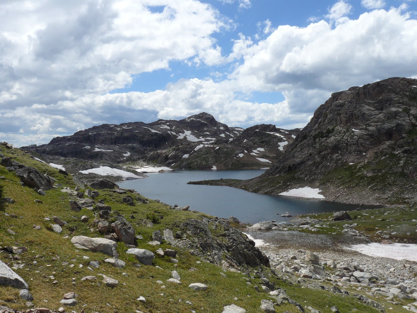
All of this day’s explorations were spent just wandering.  There were no trails.  SPHP navigated by topo map.  There were so many little lakes around, at times it was a bit confusing.  Lupe visited Lower Sheepherder Lake, Upper Sheepherder Lake, Snyder Lake, Z Lake, Lake Promise, Heart Lake and saw quite a few smaller lakes not named on the map.

Unnamed Lakes S of Lower Sheepherder Lake. Photo taken from between Frozen Lake and Lower Sheepherder Lake. Photo looks SSW.
Lupe SE of Upper Sheepherder Lake in the Beartooth Mountains.
Upper Sheepherder Lake. Photo looks NW.
Z Lake. Photo looks SW.
Ack, it's National Mosquito Day! Let's get going!
Ack, it’s National Mosquito Day! Let’s get going!
Snow on ridge NW of Lake Promise.
More snow on ridge NW of Lake Promise.
Lake Promise from the NNW.
Lupe at the overlook above Lake Promise.

The prettiest lake was a small unnamed lake above and NE of Heart Lake.  This lake was tucked in a corner of the bare higher ridge to the N and E.  There was a fair amount of snow still around there.  Lupe’s highest elevation reached was around 10,600 feet in the vicinity of Lake Promise and the little snowy lake, where Lupe and SPHP climbed considerably above both lakes.  That area was well above tree line, and Lupe and SPHP’s favorite part of the journey.

High country NW of Lake Promise on the way to the pretty unnamed lake NE of Heart Lake.
Between Lake Promise and Heart Lake in the Beartooth Mountains. Photo looks WSW.
Lupe approaching the pretty little lake NE of Heart Lake. Photo looks NW.
Unnamed Lake NE of Heart Lake, Beartooth Mountains, 7-14-14
Lupe on the snow coming towards the camera. Lupe loves snow!

SPHP's favorite photo of the pretty little unnamed lake NE of Heart Lake in the Beartooth Mountains 7-14-14
Pretty unnamed lake NE of Heart Lake in the Beartooth Mountains 7-14-13

SPHP had hoped Lupe would get to go to Snow Lake and Wall Lake, both farther NW toward Becker Lake, but too much time had been lost by SPHP getting dumped in Dump Me Creek and losing the water bottle, compounded by forgetting the camera.  Lupe did scramble clear around the N & W sides of Heart Lake over the debris of a collapsed mountainside, before following the outlet stream S down a steep canyon.

Heart Lake from the NE.
The view S before descending from Heart Lake.

Despite the self-inflicted problems early on with Dump Me Creek and the camera, the most vexing problem Lupe and SPHP faced this day was the endless horde of mosquitoes encountered.  The mosquitoes weren’t a problem until after Lupe left Frozen Lake and approached the Sheepherder Lakes.  Lupe escaped them to some degree above Lake Promise and Heart Lake, but elsewhere they forced Lupe and SPHP to stay continually on the move to avoid falling prey to them.  SPHP designated July 14th as National Mosquito Day.  Both Lupe and SPHP sincerely hoped the festivities would be completely over and done with by the next day.

Toward the end of the day, Lupe and SPHP headed back down to the G6 tramping through the forest E of Night Lake, Island Lake and Little Bear Lake to arrive at Hwy 212 just E of Little Bear Lake.  Lupe then followed Hwy 212 E back to the G6.  It was 8:28 PM when she arrived.  The sun was still up, but in the process of setting.  On the way W back to camp, SPHP stopped at a turnout.  There Lupe and SPHP watched the golden glow of the sunset fading away just to the N of Pilot and Index Peaks.

Pilot Peak (L) and Index Peak (R) at sunset, Beartooth Mountains, WY 7-14-14
Pilot Peak (L) and Index Peak (R) at sunset, Beartooth Mountains, WY 7-14-13

Links:

Next Adventure                    Prior Adventure

Want more Lupe adventures?  Choose from Lupe’s 2013 Beartooths & Canadian Rockies Adventure IndexDingo Vacations Adventure Index or Master Adventure Index.  Or subscribe free to new Lupe adventures.

The Journey to Two Bits Lake, Beartooth Mountains (7-12-13)

Lupe and SPHP first came to explore the Absaroka-Beartooth Mountains of NW Wyoming and S Montana in August, 2012 on Lupe’s first ever big summer Dingo Vacation.  Lanis had been along then, too.  Lupe and SPHP were completely enthralled with these beautiful mountains full of alpine lakes, streams and forests, and eager to return in 2013.

This glorious long day hike starts at Island Lake (elevation 9,518 ft.) in NW Wyoming and gains less than 1,000 ft., with a high point of around 10,360 ft. on a ridge reached N of Jasper Lake shortly before arriving at Two Bits Lake.  Lupe and SPHP found no discernable trail the last part of the hike beyond Jasper Lake.  The hike passes just E of Lonesome Mountain, the highest peak Lupe has ever climbed to date (6-23-15), although she didn’t climb it until 2014, about a year after making the hike that is the subject of this post.

Clicking on this blue Lonesome Mountain link will take you to the Peakbagger.com page for Lonesome Mountain which features a topographic map of this area.  Clicking on this red Lonesome Mountain link will take you to Lupe’s blog post on climbing Lonesome Mountain in 2014. 

The Island Lake trailhead is near the Island Lake campground on the N side of Beartooth Highway No. 212 in NW Wyoming.  (Both use the same access road off the highway.)  The Island Lake campground is approximately 2 miles E of the Top of the World Store & Motel or roughly 15-20 miles E of Hwy 212’s junction with the Chief Joseph Scenic Byway, Hwy 296.  Lanis & SPHP purchased topographic maps of the area at the Top of the World Store in 2012.

Lupe woke up early on the 3rd day of her 2013 Dingo Vacation to the Beartooths and Canadian Rockies.  She and SPHP had spent the night in the G6 due to rain, after having claimed their favorite camping spot on the Clark’s Fork of the Yellowstone River the day before.  It was early, but already light out.  The sky was mostly cloudy, but it was no longer raining or even threatening to rain.  Lupe and SPHP got out of the G6 eager to greet the new day in the Beartooths.

Set up on the Clark's Fork of the Yellowstone, July 2013
Set up on the Clark’s Fork of the Yellowstone, July 11, 2013

Swarms of mosquitoes were eager to greet Lupe and SPHP, too.  Lupe and SPHP beat a hasty retreat back into the G6.  Lupe snoozed another 30 minutes while SPHP made journal entries.  Eventually a squirrel woke Lupe up and she just had to get out to bark at it.  She buried the only “Minties” bone SPHP has ever given her under a tree near the tent.  SPHP resolved to retrieve it after checking out the maps for a place to go exploring.

Back in August, 2012, Lupe, SPHP and Lanis had taken a fabulous hike from the Island Lake trailhead to Beauty Lake and then doubling back to a side trail to Becker Lake.  SPHP decided exploring the area above tree line beyond Becker Lake would be great fun for Lupe.  By 10:00 AM, Lupe was setting out on the trail from Island Lake.  Lupe passed by lakes she had first seen with Lanis in 2012 including Island Lake, Night Lake and Flake Lake.  Lupe was making great progress along the trail, partly because mosquitoes became a big problem anytime SPHP stopped for even a few moments.

SPHP was watching for a side trail angling to the right that led to Mutt & Jeff Lakes and then went on to Becker Lake and beyond, and yet somehow missed it.  When the trail started to curve to the left and rapidly lose elevation, SPHP remembered it was about to descend to Beauty Lake.  SPHP realized Lupe had gone too far.  Lupe and SPHP turned around and went back in search of the side trail to Becker Lake and beyond, and this time found it.  Upon reaching Mutt & Jeff Lakes, SPHP knew for certain Lupe was headed in the right direction.

Mutt & Jeff Lakes are very close together.  The trail goes between the two lakes, crossing a broad connecting stream.  There is no bridge, but there are quite a few rocks in the stream and stranded bits of grassy or bushy land.  SPHP managed to hop across from rock to rock without getting non-waterproof boots too wet.  Lupe had no problem leaping from one rock to the next, or just wading through enjoying the cold, clear water.

Once across the stream, the trail turns NE and crosses a boulder field that extends right down to the NW shore of Jeff Lake.  Past Jeff Lake, the trail heads N up a small headwall and then along the E side of a shallow pond (more boulders here) in a saddle.

Jeff Lake in the Beartooth Mountains. The trail crosses the boulders at the base of the hill (L) and then goes up around the right side of the hill.
Jeff Lake in the Beartooth Mountains. The trail crosses the boulders at the base of the hill (L) and then goes up around the right side of the hill.  Mutt Lake is just to the left of this photo.  (Not pictured.)
Mutt Lake.
Mutt Lake.

Soon after passing the saddle, a portion of the S end of Becker Lake came into view.  Lupe followed the trail N through the woods well above the E shore of Becker Lake.  Towards the N end of Becker Lake, the trail was out in the open and closer to the lake.

There were just scattered groups of trees around as Lupe and SPHP left Wyoming N of Becker Lake and entered Montana on the way to Albino Lake.  The trail stayed on the E side of the stream coming down from Albino Lake to Becker Lake.  The last few trees were at Albino Lake (10,000 feet elevation), which is situated just E of Lonesome Mountain.  Lupe loved the open ground of the high country, although without trees there was the drawback of no more squirrels to bark at.

Part of the S end of Becker Lake.
Lupe near the trail E of Becker Lake.
Lupe near the trail E of Becker Lake.  Photo looks N.
Looking S from the trail on the E side of Becker Lake.
The stream coming down from Albino Lake on its way to Becker Lake. Photo looks N.
Lonesome Mountain (L) lies just W of Albino Lake. This photo is taken looking NW from the trail near the stream flowing out of Albino Lake.
Lonesome Mountain (11,399 ft.) (L) lies just W of Albino Lake. This photo is taken looking NW from the trail near the stream flowing out of Albino Lake.
Albino Lake and Lonesome Mountain. Photo looks WNW.
Looking S back at Becker Lake from a hill S of Albino Lake.
Albino Lake from the hill to the S.
Albino Lake from the hill to the S.  Lonesome Mountain at left side of photo.
Lupe happy in the Beartooth Mountains S of Albino Lake 7-12-13
Happy Lupe in the Beartooth Mountains S of Albino Lake 7-12-13
Lupe on the hill S of Albino Lake. Photo looks N.
Lupe on the hill S of Albino Lake.  From here Lupe went around the left (W) side of the lake and climbed over the ridge shown on the far side of the lake at the low point seen at left center.   Photo looks N.

At the SE end of Albino Lake, Lupe crossed over the outlet stream (easy rock hopping) to the W.  Lupe and SPHP went up on a hill just S of Albino Lake for a look back towards Becker Lake.  Then Lupe followed the trail NW above the W shore of Albino Lake up to the next big saddle ridge ahead.  From the saddle was Lupe’s first view of Jasper Lake.  The area around Jasper Lake was completely devoid of forest.  Rock, heather, scattered patches of snow and sky was all there was.  Gorgeous high mountain terrain was everywhere.

Jasper Lake in the Beartooth Mountains.
Jasper Lake in the Beartooth Mountains.  Photo looks N.
Jasper Lake
W side of Jasper Lake.  Photo looks N.
The NW end of Golden Lake visible from the ridge S of Jasper Lake. Photo looks WSW.
The NE end of Golden Lake visible from the ridge S of Jasper Lake. Photo looks WSW.

Lupe and SPHP were not alone, however.  Soon after reaching the saddle with a view of Jasper Lake, a troop of backpackers came traipsing up the trail from the NW.  Lupe ran over to greet them, but they soon passed on by.  The rest of the afternoon, Lupe and SPHP saw no one.  After a break enjoying the view of Jasper Lake, Lupe and SPHP continued NW on the trail, which went down to the outlet stream from Jasper Lake near the SW corner of the lake.  This stream had a lot of flow in it.

Lupe greeted these backpackers, some of the very few people Lupe saw this day. Golden Lake in background.

SPHP didn’t want to get wet feet, so Lupe and SPHP followed the S shore of the stream down all the way to Golden Lake, which wasn’t far off to the WSW.  There was no place to cross and stay dry anywhere along the way.  There was nothing to be done, except take the plunge.  SPHP and Lupe forded the stream at the delta where it enters Golden Lake.   Now on the N side of the stream, Lupe and SPHP headed back up towards the W shore of Jasper Lake.  Nearing the lake again, Lupe turned N heading for a ridge.

Stream flowing down from Jasper Lake.
Lupe near Golden Lake. Photo looks SW.
Lupe near Golden Lake. Photo looks SW.  Lonesome Mountain is on the left.
SPHP's boots got soaked crossing this stream where it enters Golden Lake. Lonesome Mountain on left. Photo looks SW.
SPHP’s boots got soaked crossing this stream where it enters Golden Lake. Lonesome Mountain on left. Photo looks SW.

Lupe and SPHP gained the top of the ridge NNW of Jasper Lake at a broad shallow saddle.  The saddle area and beyond consisted of rolling terrain strewn with a mix of boulder fields, grassy areas and small shallow lakes.  Crossing this ridge, Lupe reached her highest elevation of the day at somewhere between 10,360 and 10,400 feet.  Beyond the ridge was Two Bits Lake.  Lupe spotted a snow drift and ran down to cool off in it not far from the lake.

Looking back at Lonesome Mountain from the N on the way to the ridge NNW of Jasper Lake.
Looking back to the SE at Jasper Lake.
Looking back to the SE at Jasper Lake.  The ridge Lupe came over from Albino Lake is on the right side of the photo.
Largest of the unnamed lakes in the saddle area NNW of Jasper Lake.
Lupe on her snowbank near Two Bits Lake. Photo looks NNW.

Just S of Two Bits Lake, Lupe and SPHP stopped for a break.  Lupe chowed down on some Taste of the Wild.  SPHP celebrated success with a Coke.  After the break, Lupe and SPHP explored among the rocks above the S shore of Two Bits Lake.

Consulting the topo maps, SPHP really wanted to climb another ridge NW of Two Bits Lake and then turn N to find High Pass with the ultimate goal of reaching Sky Pilot Lake.  However, the day was wearing on and it was a long way back to the G6.  It was too late in the day to try it.  If Lupe was ever going to reach Sky Pilot Lake, she would have to come back to Island Lake and start all over again earlier in the day.

Two Bits Lake, Beartooth Mountains 7-12-13. Photo looks NNW.
Lupe takes a break SSE of Two Bits Lake.
Lupe S of Two Bits Lake
W side of Two Bits Lake. Photo looks N.

After suitable time spent admiring pretty Two Bits Lake, Lupe and SPHP followed a rock ridge SW from the lake.  Just to the NW was the outlet stream from Two Bits Lake running down to Triskele Lake.  When Lupe reached Triskele Lake it was time to turn back.  Lupe headed back up to the saddle area on the ridge NNW of Jasper Lake.  The view of Lonesome Mountain and Jasper Lake was just awesome.  Lupe saw a bald eagle fly over Jasper Lake heading E.

SPHP thought about climbing this ridge to look for High Pass and Sky Pilot Lake, but it was too late in the day to be advisable. Photo looks NW and shows SW corner of Two Bits Lake.
Looking SW down the stream from Two Bits Lake on its way to Triskele Lake.
Triskele Lake in the Beartooth Mountains from the NE.
SPHP's favorite photo of Lupe and Lonesome Mountain. Photo was taken looking S from NNW of Jasper Lake. Lonesome Mountain is much more impressive from this angle than from along the trail to the E or S.
SPHP’s favorite photo of Lupe and Lonesome Mountain. Photo was taken looking S from NNW of Jasper Lake. Lonesome Mountain is much more impressive from this angle than from along the trail to the E or S of the mountain.  A portion of Golden Lake is seen at center right.

SPHP wanted to go around the E side of Jasper Lake to avoid having to ford the big outlet stream again.  On the NE side of Jasper Lake, Lupe found a big feather near a little stream.  Perhaps it was from the bald eagle?  That was pretty cool!  There were lots of streams coming into Jasper Lake from the E, but since they were smaller, SPHP managed to stay mostly dry getting across them.   Eventually Lupe and SPHP reached the ridge to the S of Jasper Lake and found the trail again.

The eagle feather is seen just to the left of Lupe. Photo taken NE of Jasper Lake.
Lonesome Mountain across Jasper Lake from near the eagle feather.
Lonesome Mountain across Jasper Lake from “Eagle Feather Creek”.
Jasper Lake & Lonesome Mountain, 7-12-13
A last look back N at Jasper Lake.

The rest of the evening was spent retracing the trail back to the G6.  Lupe and SPHP had seen very few people all day, but on the way back SPHP did stop to talk to a fisherman on the W side of Albino Lake.  He was catching mostly 8-12″ cutthroat trout, but said he had caught a couple of 18-20″ cutthroats up at Golden and Jasper Lakes.  The fisherman was from Pennsylvania.  He claimed to have seen a white wolf.

Lupe reached the G6 again at 11:28 PM.  Lupe had been sniffing and exploring for 13.5 glorious hours!  By now, though, both Lupe and SPHP were about totally played out.  The weary dingo hopped into the G6 and curled up for a snooze.  SPHP drove back to the campsite at the Clark’s Fork of the Yellowstone River.   Arriving well after midnight, SPHP was just too tired to set things up in the tent.  SPHP covered Lupe with a blanket.  Another night was spent in the G6.  The next morning, a bleary-eyed dingo was still curled up, happily snuggled in the blanket.

Carolina Dog catches 40 winks. More adventuring lies ahead!

Although Lupe did not get as far as Sky Pilot Lake this time, 3 days later she returned and did find it.  Click on this Sky Pilot Lake link to see her post on that adventure!

Links:

Next Adventure                   Prior Adventure

Castle Mountain, the Carbon County Montana High Point with Mountaineer Jobe Wymore – Part 1: Island Lake to Two Bits Lake (8-7-20)

Want more Lupe adventures?  Choose from Lupe’s 2013 Beartooths & Canadian Rockies Adventure IndexDingo Vacations Adventure Index or Master Adventure Index.  Or subscribe free to new Lupe adventures.

Camped on the Clarks Fork of the Yellowstone River (7-11-13)

Lupe’s 2013 Dingo Vacation was off to a great start!  On her first day (7-10-13) she had been to the Elysian Fields of Puppy Happiness and spent the night on Bald Mountain in the Bighorn Mountains of Wyoming.

It had been quite a memorable evening for Lupe sleeping under the stars on Bald Mountain.   “Sleeping” is used loosely here.  At first there was some sleeping going on, but a few hours into the night, SPHP woke up suddenly to the sound of Lupe sprinting away to the W in the darkness.  She was after something, but what it might have been SPHP had no clue.  Before long she came back without being called.

Lupe just E of Bald Mountain, Bighorn Mountains, WY
Lupe just E of Bald Mountain (10,042 ft.), Bighorn Mountains, WY on 7-10-11.  The summit is kind of faded out on the left.

SPHP managed to get Lupe in her blankie and sleeping bag again, but from then on Lupe and SPHP slept fitfully.  SPHP awoke many times to hear Lupe wandering off into the night sniffing around.  Sometimes she was gone for 5 minutes or a bit more, but she always came back.  Still, SPHP spent long stretches awake, peering and listening into the darkness for the tinkling sound of the tag on Lupe’s collar.

The Milky Way above was magnificent.  Three shooting stars streaked across the night sky.  A breeze started up and blew all night.  Initially it seemed to be from the E, but as the night wore on, it blew harder and more from the S.

But I'm not sleepy!!!!
But I’m not sleepy!!!!

Sometimes Lupe came around to just sit next to SPHP out of her sleeping bag.  She wanted to be petted while she stared into the blackness listening and watching.  SPHP always did pet her.  Often SPHP managed to persuade Lupe to get back into her sleeping bag and under her blankie again.  That would last for a little while and then she would be off running and sniffing again.  It was the first time Lupe and SPHP ever slept together without a tent under the stars in the wild.  Lupe was just too stimulated and excited to sleep much.

Lupe and SPHP got up when the sun was just getting up.  It was gorgeous out except for the strong S breeze.   SPHP added Lupe’s name to the place of names.  Then Lupe and SPHP went back to the summit of Bald Mountain again before heading down to the G6.  Lupe had a great time racing around through the yellow, purple, and white flowers and what SPHP called “pom pom” plants waving in the breeze.Lupe on Bald Mountain 7-11-13By 8:30 AM SPHP had everything packed up.  Lupe and SPHP headed W down spectacular Hwy 14A out of the Bighorns.  Lupe barked frantically at cows and horses across western Wyoming.   Lupe’s route went through Lovell, Powell and Cody, WY.  She rode in air-conditioned comfort since it was hot outside – almost 90°F.

From Cody, SPHP took Hwy 120 N to the Chief Joseph Scenic Byway, Hwy 296.  When Lupe reached the Beartooth Hwy No. 212, SPHP made a beeline for Lupe and SPHP’s favorite camping site on the Clark’s Fork of the Yellowstone River.  Lupe and SPHP had discovered this prime spot on Lupe’s 2012 Dingo Vacation with Lanis.

View from the big pullout on the W side of the pass on the Chief Joseph Scenic Byway in NW Wyoming.
View of Pilot (L) and Index (R) Peaks from Lupe's favorite camping spot on the Clark's Fork of the Yellowstone River
View of Pilot (11,699 ft.) (L) and Index (11,240 ft.) (R) Peaks from Lupe’s favorite camping spot on the Clark’s Fork of the Yellowstone River

Lupe and SPHP were in luck!  Arriving at 1 PM, the favorite camping site was open.  SPHP had the tent set up within 30 minutes.  As it later turned out, not a moment too soon.  After setting up the tent, SPHP was ready to take Lupe for an afternoon outing.  Nothing really long, just for a few hours.  SPHP chose a nearby trail up Pilot Creek.

As Lupe and SPHP got out of the G6 at the Pilot Creek trailhead, some people in a big white pickup truck pulling a trailer loaded with ATV’s drove up.  They asked if Lupe and SPHP were tenting across the road.  SPHP said yes, and they said they were from Cody, WY.  Lupe and SPHP were in their favorite spot to camp.  (You know you are in a good spot when the locals think it is the best one, too!)  They asked if it would bother Lupe and SPHP, if they camped nearby.  Lupe and SPHP had no problem with that.  It’s still a free country.  They didn’t need Lupe and SPHP’s permission, although it was considerate of them to ask.

Lupe claims her favorite camping site on the Clark's Fork of the Yellowstone.
Lupe claims her favorite camping site on the Clark’s Fork of the Yellowstone.
Set up on the Clark's Fork of the Yellowstone, July 2013
Set up on the Clark’s Fork of the Yellowstone, July 11, 2013

Lupe and SPHP started up the Pilot Creek trail.  At first Pilot Creek was visible below, but the trail climbed steadily so fast Lupe was soon far above the creek.  Before long there were views of the snow-capped Beartooth Mountains to the N.  The trail went uphill so long SPHP decided they should have named it Pilot Peak trail, as the trail seemed destined to climb it.  (That SPHP, what a whiner and exaggerator!  No wonder Lupe has to call her blog The (MOSTLY) True Adventures of Lupe!)

Just about the time SPHP was considering giving up and turning around, the trail leveled out and started a more gentle up and down, so Lupe stuck with it. Lupe and SPHP were in a big valley up on the W side hundreds of feet above the creek.  There was a big mountain a few miles away with a large snow bank on it, and the trail headed for that.

Lupe and SPHP had covered about 1/2 the distance to the big mountain and arrived at a small open hill on the left side of the trail.  Except for one big dead old tree, it was open ground.  Lupe and SPHP climbed the little hill to gain, for the first time, an unobstructed view of the mountain with the big snow bank.  Pilot Creek was now closer than before, not as far below Lupe and SPHP as it had been.  A side creek with good flow was cascading very steeply into Pilot Creek from the E.  It originated from a high rocky ridge with some snow still present way up near the top.

Unfortunately SPHP had forgotten the camera.  Lupe and SPHP had gone a few miles along Pilot Creek trail.  The sky was clouding up like it was going to rain.  With no camera and rain coming, it was time to turn around.  The trip back to the trailhead was pleasant and very easy, since it was nearly all level or downhill.  Lupe had a good time barking at chipmunks.  SPHP enjoyed the view of the Beartooths, which were now directly ahead instead of behind.  It was a great welcome back to the Beartooths.  Lupe and SPHP met absolutely no one on the trail the entire time.

Back at the Clark’s Fork of the Yellowstone River, there was no sign of the people from Cody.  They must decided they weren’t going to be happy camped next to Lupe and SPHP.  SPHP arranged all of the padding, blankets, and sleeping bags in the tent, then started making beef stew on the propane stove.  Before the beef stew was even ready, it started raining lightly.  Lupe and SPHP devoured the beef stew as soon as it was done.  It was starting to rain harder.

Lupe on the Clark's Fork of the Yellowstone. Tent is set up just to the right of this photo. (Not pictured.)
Lupe on the Clark’s Fork of the Yellowstone. Tent is set up just to the right of this photo. (Not pictured.)

Since the tent leaks (everything does in SPHP’s experience!), SPHP took all of the gear out of the tent and rearranged it back in the G6.  Rain meant a night in the G6.  Lupe was very tired from running around half the previous night on Bald Mountain.  SPHP was pretty weary too.  Soon both were passed out.  At least Lupe and SPHP had claimed their favorite spot on the Clark’s Fork of the Yellowstone River for the duration of Lupe’s stay in the Beartooths!

Links:

Next Adventure                 Prior Adventure

Want more Lupe adventures?  Choose from Lupe’s 2013 Beartooths & Canadian Rockies Adventure IndexDingo Vacations Adventure Index or Master Adventure Index.  Or subscribe free to new Lupe adventures.