Lupe’s PupJoy Experience (12-6-16)

On the day after Thanksgiving, Erik told SPHP that a gift from Erik & Ana would be arriving soon in the form of an email.  Erik & Ana know how crazy SPHP is about Lupe, so they had chosen wisely.  When the email turned up a couple of days later it said “Congratulations!!  You’ve Received a Gift Subscription to PupJoy!”

When SPHP told Lupe about the email, she quickly agreed it sounded promising, despite the fact that, neither SPHP nor Lupe had the faintest idea what it really meant.

The email contained a link to claim the gift subscription, which took SPHP to a screen where basic information about Lupe had to be entered to proceed (size, age, sex – that sort of thing).  That was easy enough, but next came a few options about various subscriptions – how many boxes did Lupe want, how often, etc?

All SPHP wanted to do was claim Lupe’s free gift, not sign up for an ongoing subscription, so SPHP used PupJoy’s online chat feature and wound up speaking with a very pleasant fellow by the name of Dustin.  Dustin explained that Lupe’s free gift subscription was for a single shipment of one box.  The box would contain items chosen by PupJoy for Lupe based on the initial information SPHP had provided about her.  Only a few clicks later, Lupe’s PupJoy box was on order.

SPHP told Lupe that her PupJoy box was on its way!  Every morning after that, SPHP made a big deal about letting Lupe out on the front step to see if her PupJoy box was here yet.  Lupe enjoyed this routine, but seemed a little puzzled by it, since even using her amazingly keen Carolina Dog sensory powers, she didn’t notice a single thing different about the front step than before.

Nothing changed until the morning of December 6th.  When Lupe went out to inspect the front step, there it was!  Lupe’s PupJoy box had arrived!  Even though what might be in the PupJoy box was still a total mystery, Lupe already seemed happy.

On the morning of December 6th, 2016, when Lupe went out to check on the front step – there it was! Lupe’s first PupJoy box had arrived! She already seemed happy about it, although what might be inside remained a complete mystery.

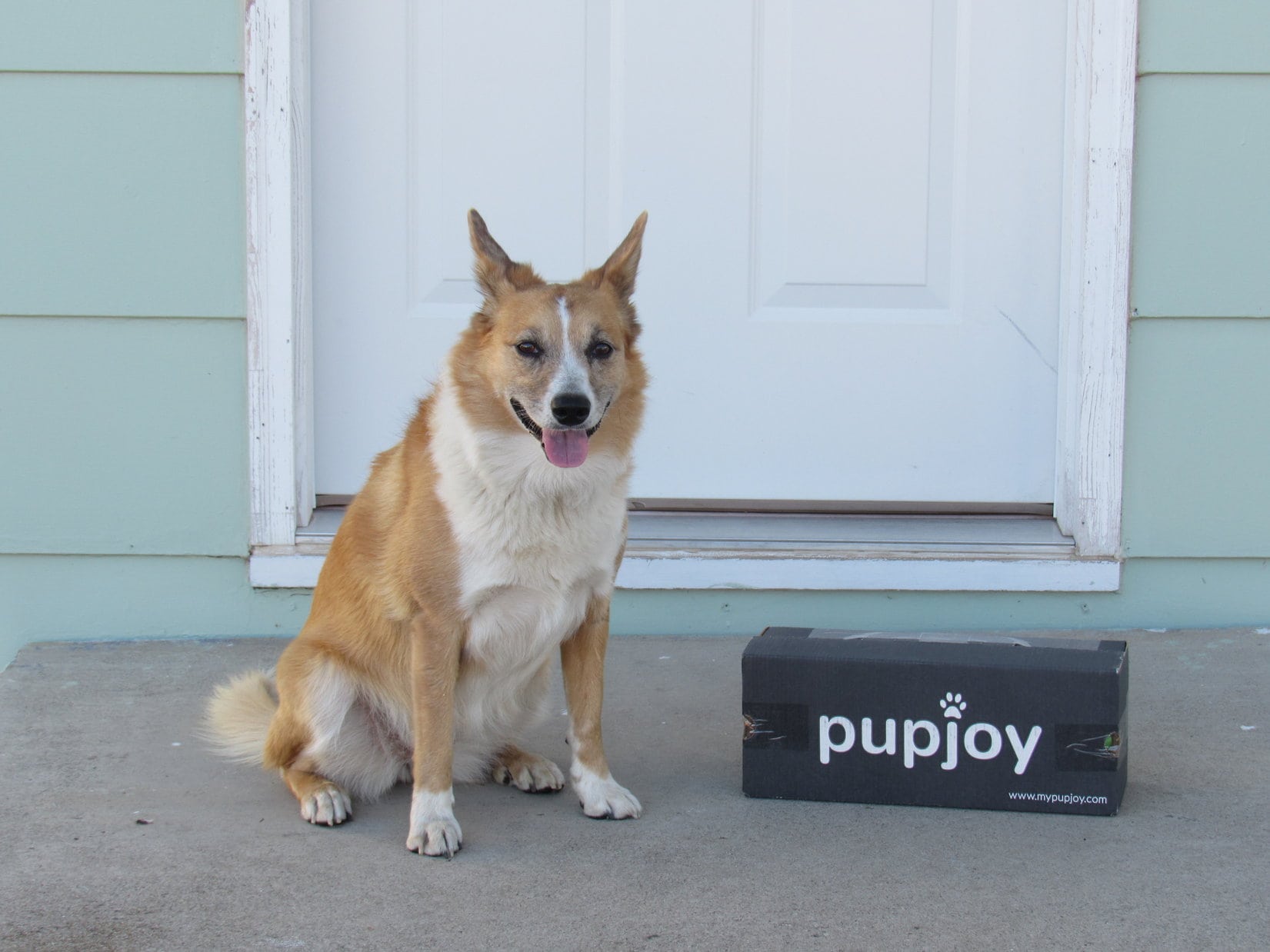
Both Lupe and SPHP were curious.  What was in this PupJoy box?

When you’re about to open a treasure chest, you don’t do it in front of the whole world.  SPHP took the box in the house.  Moments later, it was open.  Inside were 4 items – 2 dog toys and 2 bags of treats.  Before trying any of it out, Lupe agreed to pose briefly on the back step with all her newly acquired PupJoy loot.

Lupe on the back step with all her new PupJoy loot.

All of Lupe’s new possessions looked like high quality items.  SPHP was hopeful Lupe would like them.  Maybe Lupe would like to try the dog treats first?  SPHP opened the 8 oz. green bag of Down Dog Snacks – Peas, Love & Carrots flavor.  The package said they were made of All-Natural, Real, Simple Ingredients.

Lupe received an 8 oz. bag of Down Dog Snacks – Peas, Love & Carrots flavor in her PupJoy box.
According to the back of the Down Dog Snacks package, these Peas, Love & Carrots flavor treats had received the paw of approval by Rumi, the Chief Tasting Officer.

The Down Dog Treats were shaped like hearts, about the size of a half dollar.  When SPHP gave one to Lupe, she took it in her mouth, held it for a second or two, then dropped it on the ground.  SPHP gave it back to her several times.  Each time she did the same thing, except faster than before.  Lupe didn’t want one.

Well, that was disappointing.  Maybe she would like some of Grandma Lucy’s Organic Baked Dog Treats – Pumpkin Recipe?  Lupe had a big 14 oz. bag of those.  Pumpkin seemed like an odd flavor for dogs, but who knew?  Sometimes Lupe likes things one wouldn’t expect.  SPHP opened the bag.  The treats were small and shaped like little teddy bears.  Lupe could have several of them, if she liked them.  They did smell like pumpkin.

The biggest bag of treats Lupe received in her PupJoy box was a 14 oz. bag of Grandma Lucy’s Organic Oven Baked Dog Treats – Pumpkin Recipe.
The Grandma Lucy’s pumpkin recipe treats were small and shaped like little teddy bears as shown on the back side of the package. If Lupe liked them, she could have several at a time.

Unfortunately, the Grandma Lucy’s Pumpkin Recipe treats suffered the same fate as the Down Dog Snacks.  Into the mouth, then dropped almost immediately on the ground.  Lupe simply didn’t want them.  She didn’t have the slightest interest.

Normally, when Lupe gets dog treats, she practically inhales them.  One wonders if she can even taste them?  Half a second and the treats are gone, with Lupe begging for more.  Not with the PupJoy treats, though.  She didn’t want a thing to do with either of them.

Well, it was too bad.  Although Lupe sometimes likes to share oatmeal, squash, sweet potatoes and a few things like that with SPHP, Lupe wasn’t used to organic vegetable treats.  Peas, carrots, and pumpkin aren’t on the usual Lupe menu.  All the treats she gets regularly are meat flavored or animal-based – chicken, beef, pork, bacon, cheese.  Maybe Lupe would eventually get used to these PupJoy treats, if SPHP kept giving them to her over a few days?  If not, SPHP could try giving them away to a more appreciative neighbor’s dog.

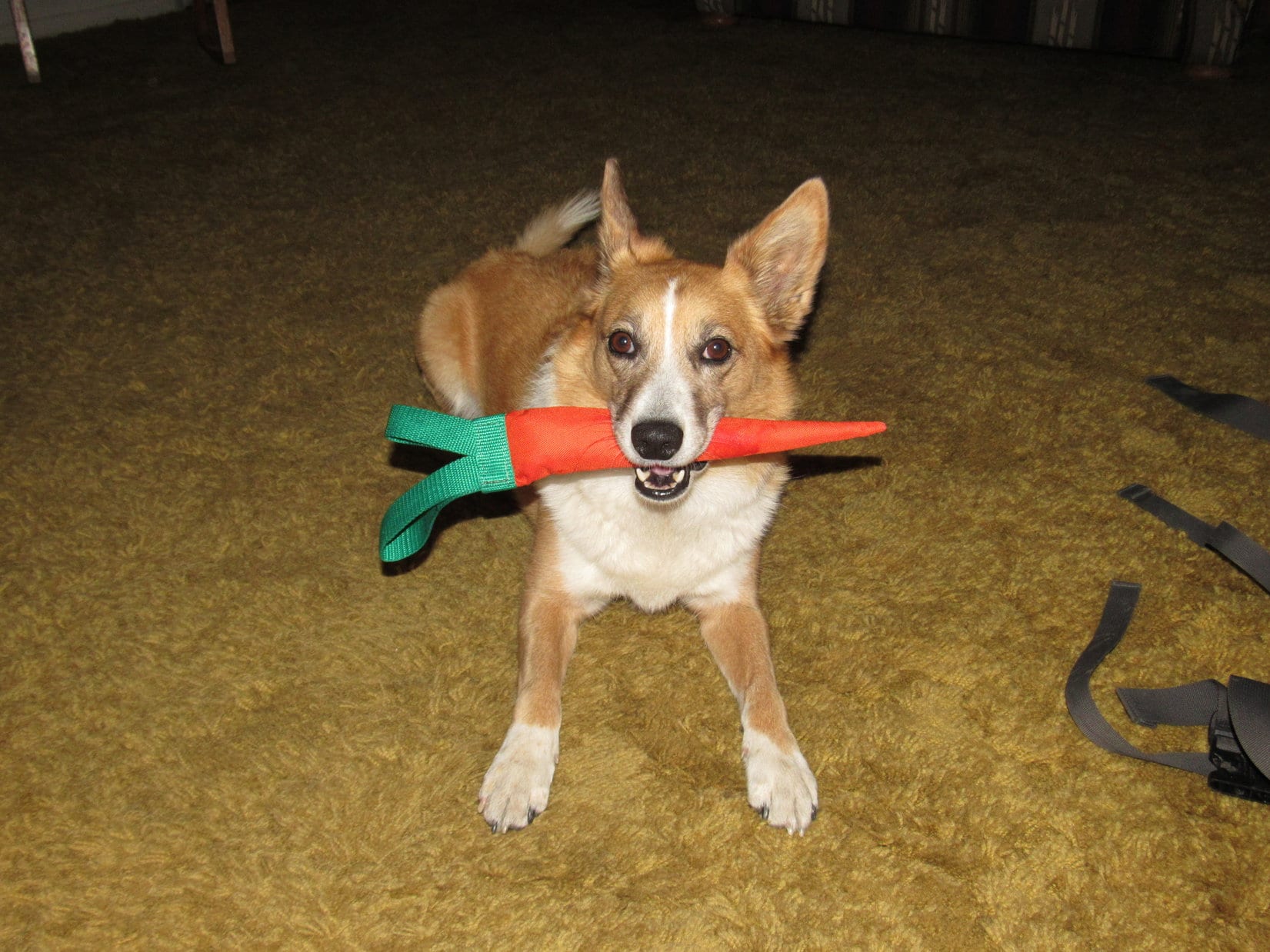
What about the PupJoy toys?  The American Dog brand carrot was bright and colorful, but seemed like a strange thing for a dog to play with.  It did have a squeaker inside.  Besides making the squeaker squeak, though, what would Lupe do with it?  Not a darn thing was the immediate response.  When SPHP offered her the American Dog carrot, Lupe sniffed it with almost total disinterest before walking away.  Hmm, so far, PupJoy was 0 for 3.  Not good.

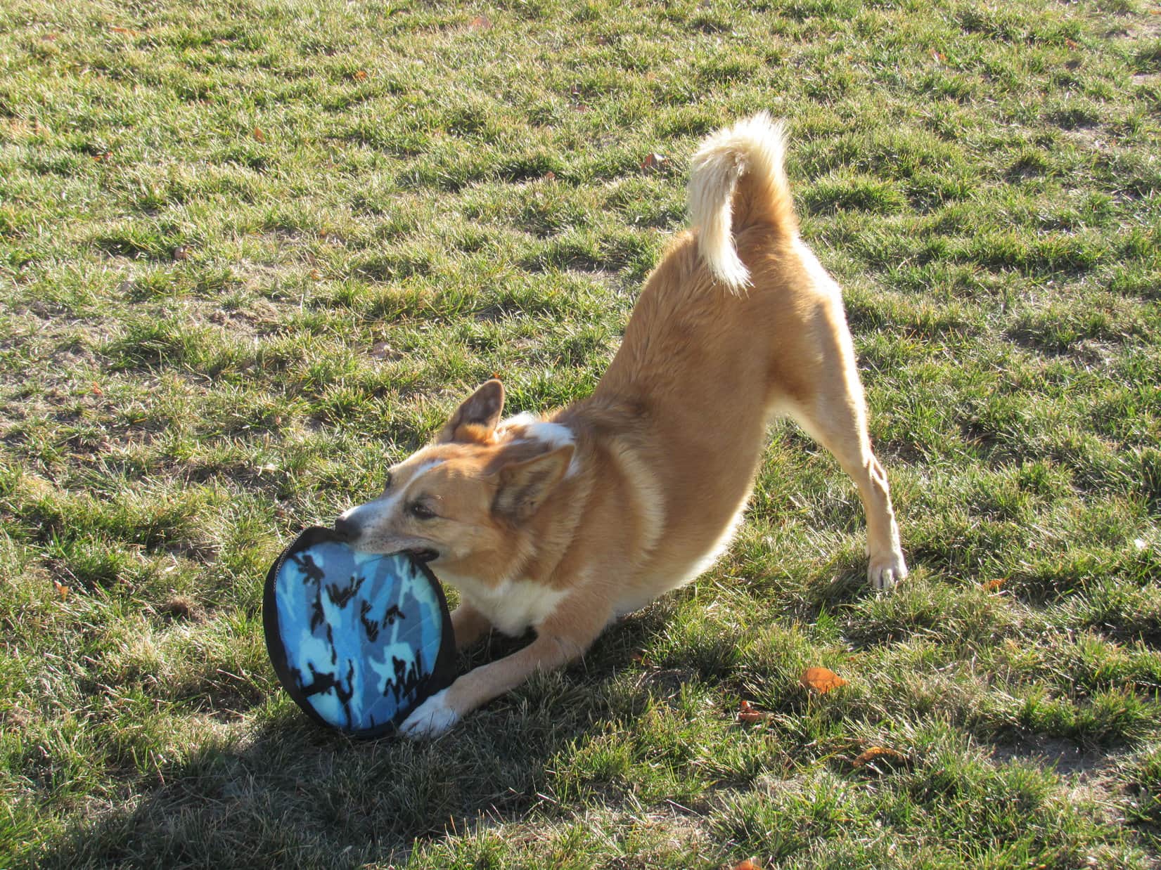
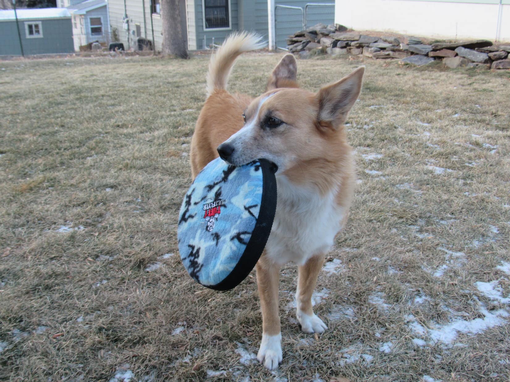
However, SPHP hoped the best had been saved for last.  The last toy was the Tuffy Ultflyer by MyDogToy.com.  It was like a Frisbee, but made of cloth.  Like the American Dog carrot, it also had a squeaker sewn inside.

The last item from Lupe’s PupJoy box that she got to try was a Tuffy Ultflyer by MyDogToy.com. It was like a Frisbee made of fabric instead of plastic.
The Tuffy Ultflyer was the last great hope from Lupe’s PupJoy box. A flying disc made of cloth did seem like a good idea to SPHP. Surely, Lupe would like this toy?

When Lupe was very young, she used to play with a hard plastic Frisbee.  She liked the Frisbee, but the hard plastic often resulted in mouth injuries that bled.  For that reason, Lupe’s early days playing with a Frisbee were confined to only a few months.  After a while, the mouth injuries didn’t seem worth it, even though Lupe completely ignored them and appeared to be having lots of fun.

When Lupe was a still growing Carolina Dog, she used to play with Frisbees, but the hard plastic often caused minor wounds that made her mouth bleed.

Lupe’s cousin Dusty has a soft pliable plastic flying disc like a Frisbee, but Lupe never plays with it.  Lupe prefers to play defense, trying to herd Dusty when Dusty tries to catch it.  Even the soft pliable plastic flying disc occasionally makes Dusty’s mouth bleed.  The worst part of it, though, is that both Dusty and Lupe will chew pieces off of it when no one is watching.

A cloth Frisbee made of really tough material seemed like a good idea to SPHP, but it had been years since Lupe had chased a flying disc.  Would she like it?

Yes, she did!  Lupe did like the Tuffy Ultflyer.  Her new flying disc was an instant hit!

Lupe and SPHP weren’t in very good flying disc form at the beginning.  SPHP found the disc rather stiff and hard to throw accurately.  Lupe’s favorite toys have been balls.  She is used to letting them bounce once before snatching them out of the air.  Lupe kept making the mistake of letting the flying disc hit the ground before trying to grab it.  The flying disc didn’t bounce at all, although once in a while it landed rolling on edge.

The flying disc almost always died right where it first hit the ground.  Still, Lupe did have fun chasing it.  In hot pursuit, Lupe kept coming to screeching stops, before scrambling back to grab it.  She then thought it was fun to try to make the flying disc squeak.  The squeaker wasn’t very loud, but those big soft Dingo ears could hear the squeaker well enough.

Lupe was very happy with her new Tuffy Ultflyer flying disc. It was the only one of the four items in the PupJoy box she showed any interest in on the day she received it.
Come on, let’s play!

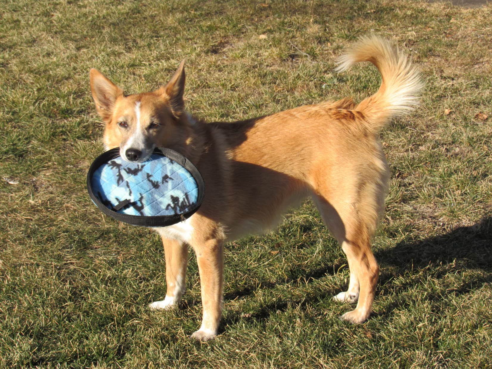
Lupe wanted to go practice with the flying disc many times that afternoon.  She kept bringing it to SPHP, who obliged her with a few more tosses each session.  Gradually SPHP was getting the hang of throwing the flying disc.  It took a while for Lupe to realize she could catch her new flying disc in the air without letting it bounce.  She had even more fun streaking after it then!

Mind flinging this flying disc for me a few more times, SPHP?
At least the flying disc was a success!

Despite SPHP offering the Down Dog Snacks and Grandma Lucy’s Dog Treats to Lupe several more times that first day, Lupe’s opinion of them hadn’t changed.  She didn’t eat a single one of either kind.  Neither did she show any interest in the American Dog fabric carrot.  1 out of 4 isn’t very good, but at least Lupe did get some real enjoyment out of her Tuffy Ultflyer.  PupJoy hadn’t struck out completely.

The next morning, there was another email from PupJoy.  This one requested feedback from Lupe.  Ouch!  It wasn’t going to be too pretty.  SPHP felt sort of bad filling out the response questionnaire, but the truth was the truth.  Besides, the opinions were really Lupe’s, and Carolina Dogs are always honest about their feelings.  Still it seemed a shame, when all the PupJoy products were high quality, and Dustin had been so nice to deal with.

On a scale of 1 to 5, with 5 being the best, SPHP gave PupJoy a ranking of only 2.  SPHP wrote a detailed explanation of what Lupe thought of each product to explain the low ranking, then hit the send button.  Nothing happened.  The feedback didn’t go through.  Maybe there was a limit to the number of characters or time taken for the response?  Technology – who knew?

No matter, PupJoy would have been disappointed in Lupe’s opinion anyway.  Although, if PupJoy was really interested in making their services better, it’s patterns of negative responses that are most apt to alert them to potential problems in need of solutions.  However, Lupe’s opinion was only a single data point.  SPHP wasn’t going to try to rewrite and resend all that again.

And that’s how things stayed until the evening of that second day.  Sometime after dark, an unexpected visitor showed up at the door of SPHP’s office.  By golly, if it wasn’t Bugs Dingo!

Aww, what’s up, SPHP? An unexpected visitor showed up at the door of SPHP’s office on the evening of the 2nd day. Bugs Dingo was here and ready for some wild American Dog squeaker carrot action!

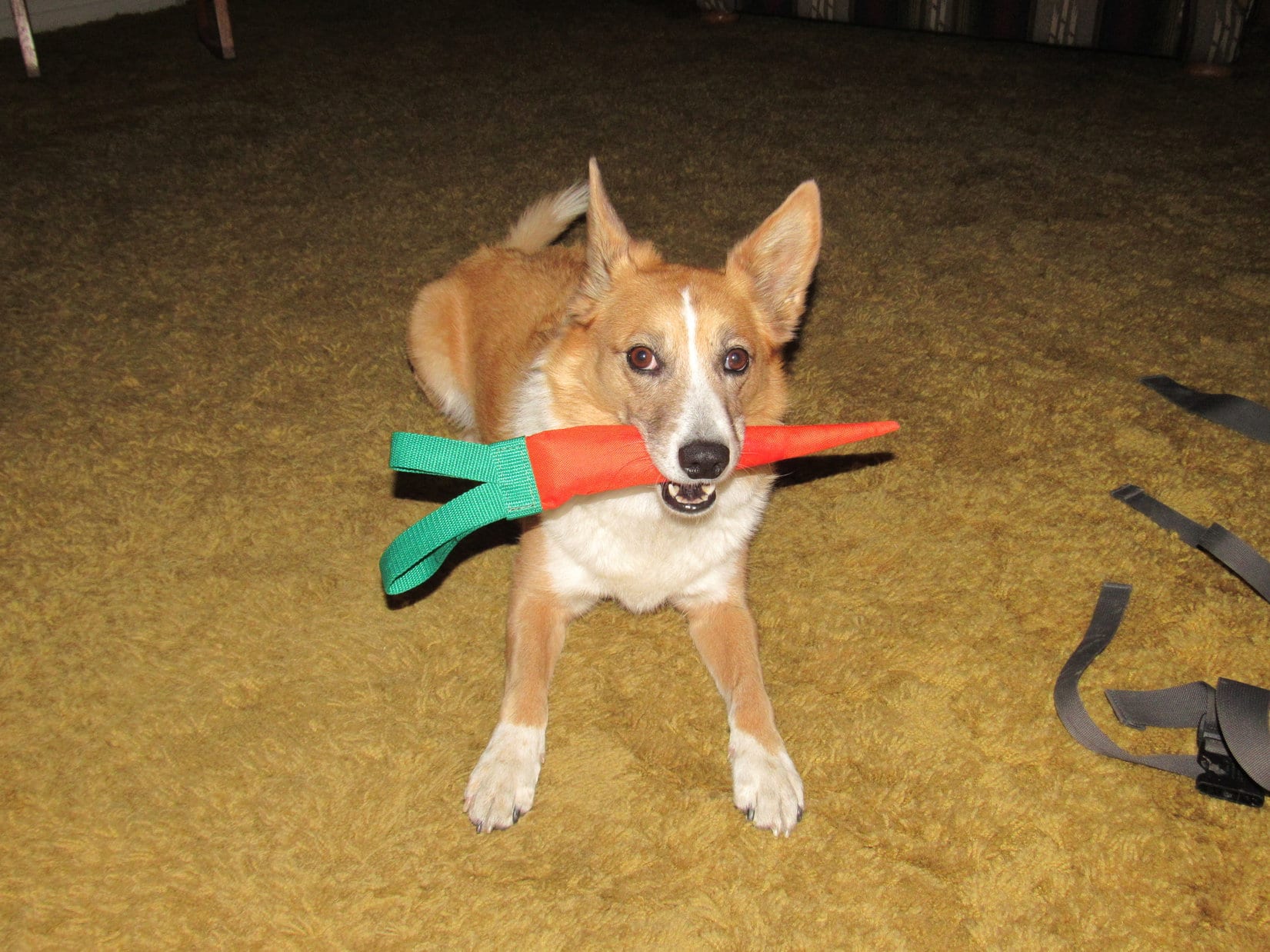
Bugs Dingo was looking bright-eyed, curly tailed, and cute as a button.  A carrot still seemed like a crazy dog toy, but Bugs Dingo had a different opinion.  She was ready for some wild American Dog squeaker carrot action!

The game was Keep Away.  Up and down the stairs.  From the living room through the hall to the bedroom and back.  Over and over again.  Bugs Dingo was lightning fast and elusive despite the confined quarters.  However, when SPHP did manage to corner Bugs and make a grab for the carrot, it was made of such slick material that Bugs Dingo had a hard time managing to hang on to it.

Keep Away evolved into Tug-O-War.  It took Bugs a while to learn how to maintain a good grip on the fat end of the carrot.  When SPHP got sole possession, the carrot was flung to the far side of the room, or up or down the stairs.  Bugs Dingo dashed after it every time, bringing it back to SPHP instantly, for more carrot fun.

The games went on to the extent of SPHP’s endurance.  Bugs Dingo didn’t want to let that carrot get put away.  She wanted to make it squeak, and like any rodent, she wanted to gnaw on it.  Bugs Dingo took it to bed with her that evening.  She wanted that American Dog carrot, and not her usual rawhide stick.

Bugs Dingo took her American Dog carrot to bed with her on the 2nd evening after it arrived in the PupJoy box. She wanted it instead of her usual rawhide stick. SPHP had to watch her so she didn’t chew it to pieces, though.

The American Dog carrot wasn’t the only thing Lupe changed her mind about.  After a couple of days of offering the Down Dog Snacks and Grandma Lucy’s Oven Baked Dog Treats to Lupe multiple times a day, only to be turned down each time, SPHP started just leaving a few treats scattered around on the floor.

At first, nothing happened.  On the floor they remained.  SPHP was about to conclude that those healthy treats really were going to have to be given away.  However, Lupe had been pondering something.  Since she was now part rabbit, as Bugs Dingo, maybe she didn’t have to be a total meat-eating predator?  Maybe some veggies were OK?

After laying on the floor for a couple of days, one morning SPHP woke up to find the treats had all disappeared.  SPHP tossed a few more on the floor.  Those disappeared, too.  Not right away, but eventually.  Gradually, Lupe was warming up to healthy veggie treats.  Grandma Lucy’s Pumpkin Recipe was her early favorite, but soon she was just as ready to accept the Down Dog Snacks Peas, Love & Carrots treats.

Over the course of a week, a new PupJoy routine emerged.  With snow on the ground, balls didn’t bounce.  During the day, Lupe preferred chasing her new Tuffy Ultflyer.  In addition to becoming quite good at catching it in mid-air, she enjoyed making it squeak.  She really liked latching onto it with her jaws, and being slung around by SPHP whirling in a circle with all 4 paws off the ground.  Whee!

Many times each day, Lupe brought her flying disc to SPHP to announce that it was time for another flying disc session.  When her birthday came on 12-14-16, Lupe started her day off right with her flying disc.

Lupe with her flying disc on her 6th birthday on December 14th, 2016.

In the evenings, Bugs Dingo wanted to play with the American Dog carrot.  Up and down the stairs, racing back and forth between rooms.  Keep Away and Tug-O-War.  When SPHP tired out, Lupe still wanted to make that carrot squeak, and still wanted to gnaw on it.  Although it’s made of tough material, SPHP had to put the carrot away to keep it from being totally demolished in short order.

On Christmas Eve, Lupe even took her carrot with her to Grandma’s house.

Lupe took her American Dog carrot with her to Grandma’s house on Christmas Eve for something to do while waiting for Santa.
Bugs Dingo at Grandma’s house. Christmas Eve 2016.

At bedtime, Lupe continued hopping up on the bed with SPHP like she usually does.  Instead of wanting her usual rawhide stick, though, she had a new idea for a nightly routine.

Apparently Lupe had read the part on the Down Dog Snacks bag about “Feed as a training snack.”  It worked!  She quickly trained SPHP to feed her more snacks.  Lupe stayed next to SPHP on the bed, happily munching and crunching away on Grandma Lucy’s Pumpkin Recipe and Down Dog Snacks Peas, Love & Carrots flavor treats.  Every so often, she would bark or growl to signal the need for a fresh supply.

So where do things stand now, nearly 2 months after Lupe received her PupJoy box?  The Tuffy Ultflyer flying disc from MyDogToy.com is looking kind of bedraggled, but remains basically intact.  SPHP continues to throw it for Lupe many times each day.

The American Dog carrot has suffered quite a bit of gnawing damage, inflicted during a couple of brief oversights when Bugs Dingo was left alone with it for a few minutes.  One of the two green tops is completely gone.  The end of the carrot is missing, and half of the stuffing torn out.  Bugs Dingo still loves the carrot, though, and still gets to play Keep Away and Tug-O-War with it most evenings.

The American Dog carrot has suffered some gnawing damage from Bugs Dingo, but Lupe still likes to play with it.

Lupe still has quite a supply of her usual treats received from Santa and other benefactors at Christmas.  However, all of the Grandma Lucy’s Pumpkin Recipe and Down Dog Snacks Peas, Love & Carrots flavor treats were munched and crunched up long ago.  Well before they ran out, it was clear Lupe was really enjoying them.

First impressions aren’t always right.  Lupe’s initial 2 out of 5 stars first impression drastically under-rated PupJoy.  Lupe wound up enjoying all 4 of the products in her PupJoy box.  SPHP thought only the carrot was a little weak for Lupe.  Even though it is made of military grade material and designed to be tough, Bugs Dingo had no problem causing significant gnawing damage in only a few minutes when left alone with the American Dog carrot.

So maybe PupJoy should have been given 3.5 out of 4 stars for the products Lupe received.  The 5th star should be saved for evaluating cost, always an important consideration.  Of course, Lupe’s first PupJoy box was a gift from Erik & Ana (thank you!), so to Lupe, the price was an unbeatable free of charge.

SPHP did a little checking online and found the following approximate retail costs for the items Lupe got in her first PupJoy box:  Down Dog Snacks $10, Grandma Lucy’s Oven Baked Treats $9, American Dog carrot $10, Tuffy Ultimate Flyer $16.70.  Total retail value of $45.70.  Since the PupJoy website shows a cost for gift boxes ranging from $23 to $44 with free shipping in the USA ($5 in Canada), it appears PupJoy does offer at least fair value for money spent, and perhaps a discount.

What it all boils down to is Lupe’s new PupJoy rating is 4.5 out of 5 stars.  Is she hoping there’s more PupJoy in her future?  Of course, she is!

Reasons to try PupJoy

  • Healthy treats with All Natural, Grain Sensitive, Protein Sensitive & Organic options
  • Premium quality toys
  • Customizable box contents – 28 possible configurations
  • Choice of subscription plans available – a one time single box; or quarterly, bi-monthly, or monthly regularly scheduled shipments
  • Gift plans available
  • Convenient home delivery
  • $2 of each PupJoy box purchase is donated to help give shelter animals a chance at life

Interested in trying PupJoy?  Tell them Bugs Dingo sent you!  Use this link to receive a $10 PupJoy welcome before ordering, and Lupe will receive a PupJoy credit, too!  Simply enter your information where Lupe’s appears and submit.  Lupe thanks you, and hopes you have a wonderful PupJoy experience, too!

Links:

pupjoy.com

$10 PupJoy welcome

Tell ’em Bugs Dingo sent you!

Want more Lupe adventures?  Choose from Lupe’s Dingo Tales Index or Master Adventure Index.  Or subscribe free to new Lupe adventures.

Dillon Mountain, Brooks Range, Alaska (8-15-16)

Day 17 of Lupe’s Summer of 2016 Dingo Vacation to the Canadian Rockies, Yukon & Alaska.

Was it foggy?  No, only condensation inside the G6.  Stepping outside, the sky was overcast.  No sunshine at all, but the clouds were pretty high.  Most of the mountaintops were in view.  Hopefully, the clouds would burn off as the day went on.

Yesterday’s feeble attempt to climb Dillon Mountain had ended before Lupe even gained any elevation.  It was SPHP’s fault.  SPHP had fallen into a blueberry trap.  All ambition had drained away as SPHP consumed blueberries, and Lupe dozed on the soft, spongy tundra.  The whole attempt had been doomed from the start, anyway.  The previous day’s climb of Sukakpak had sapped both Lupe’s and SPHP’s energy.

Today, though, this was it.  Now or never.  Lupe and SPHP left the G6 (9:41 AM, 57°F) parked N of milepost 207 along the Dalton Highway, and headed S.  Lupe followed a faint road through the forest, and then animal trails to the edge of the swamp.  Instead of trying to go SE through all those terrible tussocks again, this time Lupe went SW to the river.

Following the Bettles River S, Lupe made much faster progress than yesterday.  Part of the time it was possible to travel over exposed parts of the riverbed.  Other times, the river forced Lupe and SPHP up onto the E bank, where there were usually trails to follow.  Lupe was gaining on her first objective, a low saddle between Dillon Mountain and High Point 2003.

Looking SE along the Bettles River toward High Point 2003, the low hill at center. The S edge of Dillon Mountain is seen on the L. Lupe's first objective was the saddle between them.
Looking SE along the Bettles River toward High Point 2003, the low hill at center. The S edge of Dillon Mountain is seen on the L. Lupe’s first objective was the saddle between them.

Lupe turned SE, leaving the Bettles River when she got close to High Point 2003.  Lupe and SPHP crossed a lot of spongy ground on the way up to the saddle between High Point 2003 and Dillon Mountain.  Despite occasional wet areas with annoying tussocks, Lupe had avoided nearly all of the difficult tussock-infested swamp NE of the river.

Lupe on the N slope of High Point 2003(R). Much of the saddle area toward Dillon Mountain(L) is in view ahead. Photo looks E toward the end of Dillon Mountain's S ridge.
Lupe on the N slope of High Point 2003(R). Much of the saddle area toward Dillon Mountain(L) is in view ahead. Photo looks E toward the end of Dillon Mountain’s S ridge.

As a guide, Lupe and SPHP were using a copy of a Peakbagger.com trip report on Dillon Mountain (4,820 ft.) written by Richard Carey.  Carey, a highly experienced mountaineer, was the only Peakbagger.com account holder ever to have reported climbing Dillon Mountain.  Carey had climbed the mountain more than 21 years ago on August 4, 1995.

Carey’s trip report mentioned an old road in the saddle, but Lupe did not come to it.  Lupe and SPHP were staying on the S side of the saddle close to High Point 2003.  Maybe it was more toward the other side of the saddle, closer to Dillon Mountain?  Or maybe 21 harsh Arctic winters had obliterated the old road?

The ground was spongy with tundra moss, but otherwise travel wasn’t difficult through the saddle area.  Lupe and SPHP gave up on finding the old road, instead following animal trails that Lupe kept coming across.  According to Carey, the next objective was to reach Dillon Mountain’s S ridge, which was still a mile to the E.

As Lupe continued SE beyond High Point 2003, she came to a wide grassy area free of the tall dense bushes that grew nearby.  During wetter periods, the entire grassy area might well be a fairly large pond, but only a remnant pond was here today.  The grassy area was easy traveling.  Lupe and SPHP went along its NE edge.

Lupe beyond High Point 2003(L) near the E end of the grassy area. Photo looks WNW.

Lupe left the grassy area and High Point 2003 behind, re-entering the forest.  She angled E, toward Dillon Mountain, crossing the saddle to avoid losing elevation.  Soon she started a moderate, steady ascent traversing Dillon’s lower slopes.

Carey advised getting up onto Dillon Mountain’s S ridge, but not until beyond the steep eroded cliffs on the upper portion of the ridge. A glance at the mountain made it easy to see why.

High, steep eroded cliffs along the upper S ridge(R) of Dillon Mountain. Even without Richard Carey's sound advice, Lupe and SPHP would have avoided any attempt from this direction. Photo looks N.
High, steep eroded cliffs along the upper S ridge(R) of Dillon Mountain. Even without Richard Carey’s sound advice, Lupe and SPHP would have avoided any attempt from this direction. Photo looks N.

It wasn’t clear exactly how far Lupe needed to go before attempting to climb up onto the huge S ridge.  Lupe and SPHP simply pressed on toward the lower end of the ridge looking for any promising way up.

In the forest, Lupe crossed three boulder fields left by landslides.  The first one was small.  The next two, considerably larger.  When Lupe reached the third boulder field, a forested ramp was visible on the far side.

Lupe reaches the third boulder field she crossed. The forested ramp she would climb to reach the S ridge starts almost directly above her, joining the main ridge toward the upper left. Photo looks ENE.

Lupe crossed the boulder field, continuing on to the base of the forested ramp.  The ramp was quite steep and fairly narrow, but Lupe began the ascent.  Trees and bushes made some parts of the climb annoyingly slow for SPHP, but there was nothing new about that.

About halfway up, water was dripping from the rock wall next to the ramp.  By now, it was sunny and warm, the clouds having dissipated somewhat.  Lupe seemed to like sitting in the cold dripping water.  SPHP immediately dubbed this place the “Dingo Shower”.

Lupe at the lightly dripping “Dingo Shower” on her way up the steep ramp to the S ridge. The water dripped so slowly, it didn’t show up well in this photo.

Lupe and SPHP made it to the top of the ramp.  There wasn’t really any clear spot where Lupe gained the S ridgeline.  Instead, she kept coming to and climbing up a series of benches.  All these benches were forested, relatively steep, and separated by stretches of even steeper ground.

The climb went on and on.  Lupe gained lots of elevation.  SPHP kept trying to lead Lupe toward the NE to see what was on the other side of the ridge, but the ridge was very broad.  For a long time there was no open view.  Eventually, though, the trees began to thin out.

Finally, Lupe made it above tree line.  A steep, open slope continued relentlessly higher.  Looking E toward Wiehl Mountain, SPHP could see Lupe must still have a big climb ahead.  Wiehl Mountain still looked much higher than where Lupe was.

Lupe above tree line, somewhere on Dillon Mountain's S ridge. Photo looks NNE.
Lupe above tree line, somewhere on Dillon Mountain’s S ridge. Photo looks NNE.
Wiehl Mountain from the S ridge of Dillon. Lupe still had a considerable climb ahead of her, since the highest part of Wiehl Mountain shown here is only about 300 feet higher than Dillon. The true summit of Wiehl Mountain is higher yet, but off the R edge of this photo. Photo looks E.

Lupe climbed and climbed.  SPHP started to become concerned.  Carey had warned in his trip report that the S ridge was complex.  About 4 uplifted bands of rock run E/W across the main S ridge.  Carey said they were more easily crossed lower down on the E side.

Lupe was getting mighty high up.  Although SPHP had been trying to head NE, the S ridge was very broad.  As far as SPHP could tell, Lupe hadn’t gotten around any uplifted rock bands yet.  Fear grew that Lupe was going to arrive up on some kind of dangerous pinnacle with no way forward.

Lupe still on her way up the steep S ridge. The Bettles River(L) is seen far below. Photo looks SSE.

At last, a little tor appeared high above Lupe, perched up at the end of the long slope.  As Lupe worked her way up to it, SPHP wondered if it was the “Tor of Glad Tidings” or the “Tor of Doom”?  The answer would be clear soon.

The little pinnacle of rock (R of Center) perched at the top of the long slope. Was it the Tor of Glad Tidings or the Tor of Doom? Photo looks N.

Lupe reached a shallow saddle at the top of the slope.  SPHP’s heart sank.  It was the Tor of Doom!  Some sort of cliff was almost certainly just out of view beyond it.

The summit of Dillon Mountain could be seen ahead, still many hundreds of feet higher, at the end of the long, jagged S ridge.  SPHP had made the fatal mistake, warned against by Carey, and led Lupe straight on up the S ridge to the uplifted rock bands.

Gah!  How sickening!  Was this defeat?  How was Lupe ever going to get to the summit?  Going all that way back down to try again farther E was unthinkable.  Just getting this far had sucked up so much energy and time!

Lupe near the Tor of Doom(R). The summit of Dillon Mountain was in view, still many hundreds of feet higher, beyond the jagged uplifted rock bands of the S ridge. Photo looks N.

There was a rounded flat area to the NE, a little higher than the Tor of Doom.  Glumly, SPHP climbed up there to take a look around.  If nothing else, it was time to take a few photos of how far Lupe had made it.  Lupe followed along as happy as a clam.

Sure enough, there was a cliff directly ahead.  It wasn’t all that high, maybe 20 feet?  Didn’t matter.  No way was SPHP going to attempt to navigate it, or let Lupe get hurt trying it either.  Even if Lupe could get past this cliff, it looked like a series of cliffs continued along the ridge.  SPHP tried to figure out where Lupe was on the topo map.  Around 700 feet below the summit seemed likely.

Dang, Carey!  Why did he have to be so right?

Well, because he’s an extraordinarily experienced mountaineer!  Over 2,600 ascents logged on Peakbagger.com on 6 continents around the world!  His top 10 ascents are all over 15,000 feet, the top 2 over 20,000 feet.  You did notice that, didn’t you, SPHP?

Oh, thank you so very much Looper!  And I’m just a foolish day hiker way out of my league.  I get it, and it’s plainly hard to deny given where we are right this very minute!

No need to get sore about it, SPHP, you asked.  I still love you, and this is a fabulous spot.  Look at the views!  Aren’t you all about the views?  What’s wrong with this?  What a glorious place!

You’re right, of course.  And I still love you, too Loop, so very much.  The views are fabulous, and we are extraordinarily lucky to be here.  The only thing wrong about this place is it’s not the summit, and there doesn’t appear to be a way to it without going way, way back down the mountain.  There’s not enough time to do that, even if I had the energy.  I thought we were going to make it.  Look over there, the summit’s not all that much higher than where we are now, not compared to how far you’ve already come!  Anyway, you’re right, picture time.  We’ll take a break and think about what to do next.  Maybe we’ll come up with something.

Why hadn’t SPHP thought this all through better when clearly warned?  Nothing to be done about it now.  Take those pictures.  Lupe had certainly made it to a dramatic and beautiful spot.

Lupe on the rounded high spot even higher than the Tor of Doom. Ahead lies the summit of Dillon Mountain, but a few feet beyond Lupe is an unseen cliff. Photo looks N.
Looking SW toward Sukakpak Mountain (4,459 ft.) in the background. In the foreground on the L is one of the jagged cliffs of Dillon's S ridge.
Looking SW toward Sukakpak Mountain (4,459 ft.) in the background. In the foreground on the L is one of the jagged cliffs of Dillon’s S ridge.
Lupe was tantalizingly close, but Carey's uplifted rock bands along the S ridge posed a seemingly unsurmountable challenge to Lupe and SPHP without going way back down the mountain to try again farther E, as Carey recommended all along. Photo looks N.
Lupe was tantalizingly close, but Carey’s uplifted rock bands along the S ridge posed a seemingly unsurmountable challenge to Lupe and SPHP without going way back down the mountain to try again farther E, as Carey recommended all along. Photo looks N.
At first, SPHP thought the peak on the R was a separate mountain, but soon realized it was almost certainly High Point 4228 along Dillon's E ridge. Lupe seemed to be 100 feet lower, which would have placed her still 700 feet below Dillon's summit. Photo looks NE.
At first, SPHP thought the peak on the R was a separate mountain, but soon realized it was almost certainly High Point 4228 along Dillon’s E ridge. Lupe seemed to be 100 feet lower, which would have placed her still 700 feet below Dillon’s summit. Photo looks NE.
Looking SE toward the true summit of 5,765 ft. Wiehl Mountain.
The Bettles River is seen below on the L flowing toward its confluence with the Dietrich River (unseen) to form the Middle Fork of the Koyukuk River seen at upper L. Photo looks WSW.

Hey, wait a minute!  While taking the last photo, SPHP noticed a wide ledge of relatively level grassy ground in an unexpected direction.  It was close by to the SW, only a little below the cliff where Lupe and SPHP were standing.  Was there a way down to it?  Did it lead anywhere?

Lupe went back down to the small saddle below the Tor of Doom.  SPHP had thought there was nothing but a fearsome cliff beyond the saddle.  Getting closer to the other side, there was a huge cliff, but there was also a rocky chute leading directly down to the grassy ledge.  The ledge appeared to go up and around the 20 foot cliff Lupe and SPHP hadn’t been able to get beyond!

Looper!  It’s your Luck of the Dingo again!  Looks like we can at least make it to the next uplifted band of rock.  Come, on!

Lupe was already leading the way.  SPHP picked a way down the steep, rocky slope.  Soon Lupe stood on top of the next band of rock.  Once again, there appeared to be no way forward along the ridge, but at least Lupe was past the first cliff now!

Looking S from the top of the 2nd band of rocks back toward the low cliff(L) that had stymied Lupe and SPHP at the 1st band for a while. That 1st cliff wasn't all 20 feet high, after all. Parts of it were only 10 or 12 feet high. The low cliff still would have forced Lupe and SPHP a long way back down the mountain, if it hadn't been for the short, steep, rocky chute which led down to the grassy area below. The chute is a little hard to pick out, but is near the center of this photo.
Looking S from the top of the 2nd band of rocks back toward the low cliff(L) that had stymied Lupe and SPHP at the 1st band for a while. That 1st cliff wasn’t all 20 feet high, after all. Parts of it were only 10 or 12 feet high. The low cliff still would have forced Lupe and SPHP a long way back down the mountain, if it hadn’t been for the short, steep, rocky chute which led down to the grassy area below. The chute is a little hard to pick out, but is near the center of this photo.
Well, SPHP, the good news is we are a little higher and closer than before. The bad news is there are more rock bands and cliffs ahead. By the way, suddenly the weather's not looking so hot, either. Now what?
Well, SPHP, the good news is we are a little higher and closer than before. The bad news is there are more rock bands and cliffs ahead. By the way, suddenly the weather’s not looking so hot, either. Now what?

On top of the second rock band, Lupe was a little higher than before, and a little closer to the summit.  The view ahead was still disconcerting.  More rock bands and more cliffs.  They looked impassable.  Now what, indeed?

Looking around, it appeared that Lupe might be able to get by this 2nd cliff by following the rock band she was on down to the SE.  About 150 feet lower, the rock band looked like it broke up enough to destroy the cliff’s continuity.  Lupe should be able to get around it down there.  Only 150 feet of elevation loss was tolerable, but once she was beyond the 2nd rock band, then what?

The valley between the main S and E ridges was in view.  Off to the NNE, SPHP could see sort of a gap in one of the biggest bands of rock sloping down the mountain.  The gap was at a point not too far below Lupe’s current elevation.  If she could get around this 2nd cliff, and make the traverse over to and through that gap, she would be well on her way to the middle of the SE valley.  The SE valley was very steep, but maybe Lupe could climb straight up it?

Well, Loopster, that valley doesn’t look any worse than Decoeli (7,650 ft.), and you made it up that.  Let’s see if we can get over there.

150 feet of elevation loss to get around the 2nd cliff turned out to be more like 300 feet.  Lupe was 1,000 feet below the summit again, but at least she could resume climbing slowly once more, while angling toward the gap.  More importantly, by staying well below the S ridgeline as Carey had advised, Lupe could hopefully bypass any more difficulties with cliffs and rock bands.

The summit of Dillon Mountain disappeared from view.  A cloud passed over, sprinkling rain.  SPHP called a halt to put on an old blue plastic rain poncho.  It wasn’t very good, but helped some.

That’s your emergency rain gear, SPHP?  You look like the Cookie Monster!

Yeah, yeah, let’s go, Dingo!

The plan worked!  Lupe and the Cookie Monster made it to the gap and beyond.  Blue sky reappeared.  The blue rain poncho went back in the pack.  Lupe reached the middle of the SE valley.  SPHP began plodding slowly straight up the steep slope.  The climb was easiest where there was a little heather, and not just loose rocks.  Fortunately, for a while, there were plenty of heather routes to follow.

Way down below, something was moving!  A small herd of mountain goats was running single file across the valley.  They disappeared over one of the rock bands of the S ridge.

Lupe heads for the SE valley. Photo looks NNW.
Lupe reaches the middle of the SE valley. The summit is still way, way up there! Photo looks NW.
Mountain goats ran single file across the SE valley far below. They soon disappeared over one of the rock bands of the S ridge. Photo taken using the telephoto lens.

The steep climb seemed endless.  Lupe became bored with SPHP’s dreadfully slow pace.  She began roaming at will all over the vast SE valley, as if she was a mountain goat herself.  She often went out of SPHP’s line of sight, reappearing suddenly hundreds of feet above or below.  She returned frequently to check on SPHP’s snail-paced progress.

The energy Lupe displayed was astounding!  Once, SPHP became worried.  Lupe couldn’t be spotted anywhere.  SPHP called and called her.  In a couple of minutes, a tiny American Dingo appeared at least 500 feet down the mountain, racing practically straight up.  It only took her two minutes to reach SPHP, arriving breathless and panting like a steam engine.

Loopster!  That was incredible!  You could be at the summit in 3 minutes, couldn’t you?  Take it a little easy, though, and stay closer.  You’re going to bust a lung doing that!

Bit by bit, the summit was getting closer.  SPHP was almost certain Lupe was going to reach the top of Dillon Mountain.  Unfortunately, the weather had been deteriorating again for some time.  Blue sky was losing the battle against the spreading gray clouds.

Gray clouds spread across the sky as Lupe and SPHP progressed up the very steep SE valley. Wiehl Mountain(L) is disappearing from view, but the Bettles River can still be seen. Photo looks SE.
Lupe was having a grand time roaming the SE valley while climbing Dillon Mountain. Although SPHP was gradually getting closer to the summit, clouds kept obscuring it. Photo looks NW.

300 or 400 feet below the summit, it started raining again.  Lupe was so close to success, there was no way she was turning back, even if there wouldn’t be anything to see except fog.  Sometimes there were still breaks in the clouds.  SPHP continued to hope Lupe would have some kind of a view.

Since it wasn’t raining hard, and the showers were intermittent, SPHP was slow to put the Cookie Monster costume back on again.  Another mistake.  SPHP wound up getting fairly wet.  Should have done it earlier.  The Cookie Monster costume didn’t come off again the rest of the day.  Lupe’s fur was all soaking wet and cold to the touch, but she wasn’t shivering at all.  She still seemed to be in great spirits.

The climb got tougher.  Heather was virtually non-existent.   Lupe and SPHP climbed among loose, wet, gray rocks.  There were bigger, more stable rock formations over toward the E ridge.  SPHP worked over that way.  The climb remained very steep.  Rocks were sliding and tumbling with every step.

Carey had suggested finishing the climb up on the upper E ridge, which leads directly to the summit.  However, it looked like pretty rough going on top of the ragged ridgeline.  SPHP stayed just below the firm rock formations, using those rocks for assistance.

Not too much farther to go! Photo looks W from a little below the top of the ragged E ridge.

Perhaps 200 feet below the summit, Lupe reached a sizable, nearly level area with a thin covering of heather right up on top of the E ridge.  As expected, the ridge proved too rough to stay up on it.  The climb got even steeper, as Lupe and SPHP continued up a little S and below the ridgeline during frequent rain showers.

Lupe returned to the top of the E ridge again above a large rock formation.  She was on another fairly roomy level spot.  There was a patch of heather, but this level area was mostly covered with sand.  A steep slope of sand and small rocks led up to a small saddle between two rock outcroppings about 30 feet higher up.  The summit!  Was it true?!  If so, Lupe was almost there!

Lupe on the final, short sandy slope to the summit. Photo looks W.

A minute or two later, Lupe was there, perched high on Dillon Mountain right next to the summit cairn!  Lupe received exultant congratulations and praise from SPHP, who shook her expert mountain-climbing front paws enthusiastically.  The luck and persistence of the Dingo had prevailed!

Lupe perched next to the summit cairn on Dillon Mountain, Brooks Range, Alaska (8-15-16). Photo looks WNW.
As far as SPHP knows, Dillon Mountain is the northernmost peak any Carolina Dog has ever been seen on.

It wasn’t raining when Lupe reached the top of Dillon Mountain.  The clouds had lifted somewhat, too.  The views, although not nearly as clear as they had been 2 days earlier on nearby Sukakpak Mountain, were still incredible and much better than SPHP had expected.

The Dietrich River, Dalton Highway and even the Alaskan oil pipeline are seen far below. Photo looks NNW.
The 50 foot long summit area on Dillon Mountain featured two rocky high points separated by a saddle that wasn't much lower than either one. The N high point where the summit cairn sat was only moderately higher than the S high point pictured here. Photo looks S.
The 50 foot long summit area on Dillon Mountain featured two rocky high points separated by a saddle that wasn’t much lower than either one. The N high point where the summit cairn sat was only moderately higher than the S high point pictured here. Photo looks S.
Looking down the sandy slope at the last nearly level spot Lupe had reached along the E ridge on the way up. Wiehl Mountain(R) is seen across the valley. Photo looks ESE.
The small prominence seen R of Center is part of the start of the S ridge. Wiehl Mountain(L) again in the background. Photo looks SE.

Tremendous cliffs were in every direction, except toward the steep valley to the SE where Lupe and SPHP had come up.  While SPHP took photos, Lupe nestled down in a relatively sheltered spot among the rocks and sand in the saddle between the N and S high points.  A gigantic cliff was only a couple feet away.

Our soggy Carolina Dog heroine tries to nestle on rocks and sand in the only slightly lower saddle between the N and S high points. A gigantic cliff is only a couple feet beyond her. Photo looks W.
Comfy! Hmm, maybe not so much, but it will have to do. Photo looks W.
Sukakpak Mountain, which Lupe had climbed only 2 days ago. Photo looks SSW.
Looking down the infamous jagged S ridge. Bettles River below. Photo looks SSE.

SPHP realized Lupe wouldn’t be able to spend much time up on Dillon Mountain.  Fog and rain showers were visible in many directions.  Nearly all distant mountains were obscured by clouds.  Rain could start in again any time.

It was also getting late in the day.  Although Lupe had demonstrated that she could have made the entire round trip to Dillon Mountain and back in only an hour or two, dawdling around waiting for SPHP to drag up the mountain had taken nearly forever!

A patch of blue sky appears above the Dietrich River. It sill looked like there could be more rain coming at almost any time. Photo looks NNW.

Roughly 20 minutes after Lupe arrived at the summit, the rain hit again.  Most definitely time to go!  Lupe and SPHP were already underway, when suddenly there came a single loud peal of thunder.  Lupe never heard another one, nor did she see any lightning, but the thunder lit whatever fire could be lit under SPHP.  From then on, it was down the mountain, as fast as possible.

As fast as possible wasn’t fast at all.  Going down the super steep slope was harder and slower than climbing it had been.  Rocks slid out from underfoot, tumbling hundreds of feet.  It rained often, sometimes rather hard.  Poor Lupe was absolutely drenched.  When she was finally far enough down the mountain so there was some vegetation, she tried desperately to dry herself off on the heather.  It didn’t work.  Everything was soaking wet.

There was no point in trying to go back to the S ridge where Lupe had left it.  The sun would be down soon.  SPHP didn’t think it would be possible in fading light to find the steep forested ramp where the Dingo Shower was in order to get down off the ridge.  The plan was to just head straight on down the SE valley, then follow whatever river was at the bottom around the S end of the mountain.

Down, down, down!   Lupe reached a waterfall in the SE valley.  Below it, the valley was narrow and steep on both sides.  The terrain forced Lupe and SPHP down onto the valley floor, which continued to lose elevation rapidly.  Fortunately, the stream was underground nearly all the time.

Lupe below the waterfall in the SE valley. She had already lost a tremendous amount of elevation.

Below the waterfall, Lupe continued to lose lots of elevation.  Finally, SPHP grew worried.  Hours had gone by since leaving the summit.  The sun must be down by now.  The end of the SE valley looked like it was still a long way off.  There was almost certainly a river of some sort at the bottom.  What if it went through a narrow chasm boxed in by cliffs?  Lupe and SPHP would be stuck out here all night.

That didn’t sound good at all.  SPHP had come prepared only for a day hike.  No tent or supplies.  SPHP had matches, but there was no way to start a fire with everything totally drenched, and more rain coming.  Other than cold hands, SPHP was fine.  Lupe, however, had been cold and wet for a long time now.  She still wasn’t shivering, but what would happen when it got too dark to be moving around generating heat?

Maybe it was better to get out of this SE valley, and try going around the mountain now, while there was still some light?  SPHP decided it was the best option.  Lupe and SPHP left the SE valley, entering the forest.

The forest floor was covered with thick, spongy, wet moss.  It was a lot easier to move here than down in that interminable SE valley.  SPHP charged through the woods.  Lupe seemed to realize there was a need for speed.  She sniffed frantically everywhere, searching out the best routes ahead.  Clouds obscured much of the precious twilight.  Rain continued sprinkling now and then.

After a while, there were cliffs to the SSE.  A river was in view farther down the mountain.  Lupe and SPHP stayed above the cliffs, turning more to the SW.  The dark outline of Sukakpak came into view ahead.  That was great news.  Lupe was making progress!

Lupe started coming to landslides full of rocks and boulders.  At one of the first landslides she came to, there was a particularly big rock.  SPHP laughingly asked Lupe if she remembered that rock.  Lupe whined.  How odd!  Then it struck SPHP.  That rock did look faintly familiar.

SPHP looked around, back the way Lupe had just come.  Even in the growing darkness, SPHP was almost certain of it.  This was the landslide near the Dingo Shower ramp up to the S ridge.  In fact, there was the Dingo Shower ramp, barely visible in the gloom.  Lupe was already past it on the way back.

Haha, Loop!  We’ve got it made now!  Since we aren’t going to die of hypothermia tonight after all, maybe we should try to avoid being eaten by grizzlies, too?

SPHP started to sing.  SPHP is a terrible singer, but if you are trying to drive away grizzly bears, how good do you have to be?  What the singing lacked in quality, SPHP made up with volume.  The song of the hour was, of course, She’ll Be Comin’ Around the Mountain!

Lupe crossed the next 2 landslides, she passed through the saddle between Dillon Mountain and High Point 2003, this time staying much closer to Dillon Mountain.  She even seemed to find a stretch of Carey’s old road here, though it was hard to tell for certain in the darkness.

Nearing the Bettles River, there were troubles crossing a couple of ravines with water and mud in them.  SPHP finally just plunged right through, getting soaking wet feet.  Along the river, SPHP got stuck in dense stands of tall bushes, while Lupe continued racing around sniffing as if they didn’t exist.

Lupe drove those 6 white horses around the mountain a zillion times, but at long last she reached the Dalton Highway and the G6.

It must have been after midnight when Lupe jumped in.  Up on her stack of pillows and blankets, she started licking herself frantically.  SPHP toweled her off, fed her an entire can of Alpo, and put her special blankie on her.  She soon felt much warmer, and fell asleep almost immediately.

The Cookie Monster costume was in tatters.  SPHP was soaking wet and cold, too.  SPHP tore off the old blue rain poncho, stripped down, toweled off, and put on dry clothes.  Better!  Now to turn on the heater in the G6, and enjoy the luxury of warmth.  Click…  Click?!  Nothing but click?  Nope.  Click was it.  The battery was dead.

Lupe climbing Dillon Mountain, Brooks Range, Alaska 8-15-16
Climbing Dillon Mountain, Brooks Range, Alaska 8-15-16

Spiffy.  Nothing to do about it now.  SPHP piled on every available blanket and snuggled down under.  The battery was just going to have to wait until morning.

Related Links:

Next Adventure                            Prior Adventure

Sukakpak Mountain, Brooks Range, Alaska (8-13-16)

Lupe’s Last Mile North, Brooks Range, Alaska (8-14-16)

Want more Lupe adventures?  Choose from Lupe’s 2016 Canadian Rockies, Yukon & Alaska Adventure Index, Dingo Vacations Adventure Index or Master Adventure Index.  Or subscribe free to new Lupe adventures.

Black Hills, SD Expedition No. 188 – Peak 6181, Peak 6040 & Custer Mountain (1-18-17)

2017 was the pits!  Dullsville.  Cold, cold, cold.  And snowy.  Day after day, Lupe stared out the window.  She would heave a big sigh after a while, give up, and go lay on the couch looking like she’d lost her last friend.  Now and then she got to chase her new PupJoy flying disc across the glacier in the back yard, but that was about it for excitement.  With temperatures hovering near zero, she wasn’t even getting her usual evening walks.

However, temperatures had started creeping up the last few days.  The snow began to melt a little.  Finally, this morning’s forecast called for blue skies and unseasonable warmth.  SPHP asked if Lupe would like to go hiking in the mountains?  Lupe could hardly believe her big soft Dingo ears!  If barking, racing around in circles, and leaping for joy mean anything, she was more than ready!

Lupe had spent most of her Black Hills expeditions in 2016 climbing peaks around the SW, NE and NW perimeters of the Black Hills.  In the fall, she even ventured way up into the Bear Lodge mountains in NE Wyoming.  SPHP had expected that by the time 2016 was over, there wouldn’t be many named peaks remaining in the Black Hills that Lupe hadn’t climbed at least once – a handful, but not many.

However, Brian Kalet, a very active mountaineer from Colorado, had come through the Black Hills in May of 2016 to climb a curious set of peaks mostly concentrated in the southern Black Hills.  Brian had added all of them to the Peakbagger.com data base.  When Lupe is logged in to her account, these peaks show up as red circles on the topo map, meaning she hasn’t climbed them.  And Lupe doesn’t allow red circles in her Black Hills home base without a good reason!

Why had Brian come here?  And why had he climbed such an odd combination of mostly unnamed peaks?  The only clue SPHP could find was that all of Brian’s ascents here had over 300 feet of prominence.  Prominence is the vertical distance a peak rises above the highest col (meaning pass, ridge, or saddle) connecting it to a higher summit.

Perhaps Brian had been deliberately searching out mountains with at least 300 feet of prominence?  That’s a metric tracked on Peakbagger.com, and Brian Kalet has climbed over 3,100 different such peaks, the second most of any account holder.  Nothing else seemed to make any sense.

Whatever Brian’s reasons, now that it was 2017, it was time for Lupe to turn those annoying red circles on the map to green.  They had been taunting Lupe long enough!  She’d gotten a head start on the Brian Kalet peaks by climbing Peak 5688 and Peak 5440 in December.  Next up on her list was Peak 6181, located 1.5 miles NW of the town of Custer.

Mica Ridge Road goes very close to Peak 6181, but a quick scouting trip proved the property along the road was all privately owned.  SPHP resorted to parking the G6 at a pullout for an “interpretive site” on the E side of Hwy 385 (9:14 AM, 41°F).  From here, Lupe had USFS land access all the way to Peak 6181.

The mountain was only 1.25 miles off to the SSW.  Lupe crossed over to the W side of Hwy 385, and started climbing a fairly steep slope.  She had to leap through nearly foot deep snow, which easily came up to her belly.  Lupe likes snow, though.  She was excited to be out in the hills again, and having a good time.  Up the thinly forested slope she went, heading for the top of a ridge.  She reached it at a saddle between two minor high points.

The top of the ridge had less snow, only half a foot in most places.  Lupe crossed level ground leading to the nearest high point to the S.  After a short climb, she was there.  Thunderhead Mountain (6,567 ft.), where the Crazy Horse Memorial is located, was in view to the N.  Off to the SW, Lupe could see her objective, Peak 6181.

From the first minor high point Lupe reached, the Crazy Horse Memorial on Thunderhead Mountain was in view. Photo looks N using the telephoto lens.
Off to the SW, Lupe could see her objective, Peak 6181 (Center).

S of the minor high point, Lupe saw a thickly forested hill.  This hill was nearly as high as Peak 6181, but she didn’t need to climb it.  Instead, Lupe went S only far enough to reach a logging road that headed SW.  Near this road was a dramatic looking rock outcropping, the top of which leaned out into space.  It reminded SPHP of a petrified artillery gun, thereby acquiring the name Artillery Rock.

Lupe near the dramatic, overhanging rock outcropping known henceforth as Artillery Rock. Photo looks W.

Snow had drifted onto the logging road as much as 2 feet deep in places, which was pretty deep for Lupe.  Often there was less snow off the road.  Bare ground existed in a few places with a lot of S exposure.  Yet plentiful slash and debris left off-road by the loggers frequently made the road easier to deal with despite the snow.  Lupe continued SW toward Peak 6181 following the road closely, but not always right on it.

Although at times a bit of a struggle for Lupe, the trek along the road was pretty.  The snow was still quite frosty and crunchy.  In many places it was unspoiled by any tracks.  Snow crystals sparkled in the bright sunlight like tiny jewels.  Big granite rock formations nearby added scenic interest.

Lupe on the logging road. Peak 6181 is dead ahead. Photo looks SW.
Snow crystals sparkled like tiny jewels in the bright sunlight.
Getting closer! Granite rock formations near the logging road like those on the R added scenic interest to Lupe’s trek. Photos look SW.

The climb to the top of Peak 6181 was easy, and didn’t take long.  Lupe followed the NE ridge up.  Soon she was standing on the highest rocks at the summit.  Hah, success!  Another red circle on the Peakbagger.com topo map would turn green for Lupe!

Lupe stands on Peak 6181’s highest rocks! Photo looks W.

Lupe had surprisingly good views from Peak 6181.  Most of them were from points a little below the top of the mountain.  Too many trees blocked the views at the summit, although Lupe did have open views toward the W and NW from there.  Atlantic Hill (6,393 ft.) and Bear Mountain (7,166 ft.) were among the peaks she could see from the summit.

Looking NW toward Atlantic Hill and Bear Mountain.
Atlantic Hill is in the foreground slightly L of Center. Bear Mountain is the high, long ridge seen beyond it. Photo looks NW using the telephoto lens.
Looking SW using the telephoto lens.

Even though it hadn’t taken Lupe terribly long to get here, the snow had made the journey considerably more strenuous than it ordinarily would have been.  Lupe and SPHP took a short break at the summit.  Loopster wasn’t hungry yet, but SPHP munched on a few carrot sticks.  Lupe curled up on the ground near SPHP’s feet.

After break time, Lupe went to see the rest of the views from points a little lower down.

Northeast Cicero Peak (6,240 ft.) (Center). Photo looks SE using the telephoto lens.
Harney Peak (7,242 ft.), South Dakota’s highest mountain, was only visible between the trees from one little spot on the NE slope of Peak 6181. Photo looks NE.
Harney Peak using the telephoto lens.
Mount Coolidge (6,023 ft.) is the high point straight up from Lupe’s shoulder. Custer Mountain (6,089 ft.) is straight up from her tail. Photo looks SE.
Sylvan Peak (7,000 ft.) (Center). Photo looks NE.
Buckhorn Mountain (6,330 ft.) (R of Center). Photo looks ENE.

With her exploration of Peak 6181 complete, Lupe returned to the G6 by the same route (11:50 AM, 55°F).  Since it wasn’t even noon yet, Lupe had plenty of time to climb another mountain.  Her next objective was Peak 6040, located a couple miles SW of Custer.

The plan was for Lupe to also climb Custer Mountain (6,089 ft.), if there was enough daylight remaining after Peak 6040.  SPHP parked the G6 at the intersection of Lower French Creek Road and USFS Road No. 341, about 0.75 miles NNE of Custer Mountain (12:06 PM, 54°F).  Lupe set off heading W on No. 341, which was snow-packed.

For a mile, Lupe stayed on No. 341, gaining elevation gradually the whole time.  She then left the road to climb S toward a saddle between High Points 5900 and 5998 on the topo map.  She found a snowy logging road near the saddle, but did not follow it.  Instead, she turned SW toward High Point 5998.  For a while, she had an easy time climbing along a fairly broad, rounded ridgeline.

Lupe had an easy time climbing this fairly broad, rounded ridge on her way to Peak 6040. Photo looks SW.

Lupe tried to bypass High Point 5998, skirting it to the SE.  However, this side of the mountain became progressively steeper, and was littered with increasing amounts of deadfall timber.  Snow made things so slick, that SPHP started slipping.  After a few minor stumbles, SPHP decided Lupe had better head up to the ridgeline.

By now, Lupe was already close to the top of the ridge.  She reached it in only a couple of minutes.  Lupe had succeeded in bypassing High Point 5998 to some degree, but wasn’t far S of the very top.  Only a little farther S was a nice level spot with some grass, and a wide open view toward the town of Custer.

S of High Point 5998 on the way to Peak 6040, Lupe had a great view toward the town of Custer. Peak 6181, which she had climbed earlier, is seen beyond the town a little L of Center. Photo looks NW.

The ridge leading SSW toward Peak 6040 was narrow and rocky.  Peak 6040’s summit was only 0.33 mile away, but this route was very slow going.  Medium-sized rocks sitting at all sorts of angles dominated the whole length of the narrow ridge.  On both sides, the terrain was steep and full of trees, deadfall, and more rocks.  To the E there was also snow.

Lupe on a typical stretch of the narrow, rocky ridge leading SSW to Peak 6040. There weren’t any cliffs or other dangers, but the ridge was full of obstacles that made this route very slow. Photo looks SSW.

Lupe had no choice, but to pick her way forward through all the obstacles, while staying on or very close to the ridgeline.  Gradually, both sides of the ridge kept getting steeper and more difficult.  The rocks on top increased in size as Lupe continued S.  SPHP began to fear Lupe might come to rocks so big she couldn’t climb over or get around them.

The ridge kept getting steeper on both sides, and the rocks on top were getting bigger and harder to climb or maneuver around. Photo looks SSW.

Fortunately, that never happened.  Lupe managed to reach the top of Peak 6040.  The highest rock was only about 50 feet N of the S end of the ridge.  The skinny summit rock was standing on end.  It was barely wide enough for Lupe to balance on, but she hopped right up on it.

Lupe stands on the highest rock of Peak 6040 to claim another peakbagging success! SPHP had started to fear she might not be able to reach the summit from the ridge she had been following. Fortunately, the ridge became a little wider, and the rocks smaller, shortly before Lupe reached the top. Photo looks SSW.

There weren’t any views to speak of from the summit rock due to the forest.  Lupe and SPHP went on to the SSW end of the ridge, where there were at least some views to the S.  Due to the S exposure, the ground was snow-free and dry.  Lupe and SPHP stopped for a break.  Lupe still wasn’t hungry.  SPHP consumed the rest of the carrot sticks.  Lupe curled up with her head resting on SPHP’s leg.

From the end of the ridge, Lupe had a good view of Northeast Cicero Peak. Photo looks S.
Far to the SSW, Lupe could also see Parker Peak (4,848 ft.) (the small hill at Center). Parker Peak is the high point of Fall River County. Photo taken using the telephoto lens.

It had taken much longer to reach Peak 6040 than expected.  SPHP sat looking at the partial views, petting Lupe, and pondering what to do next.  The original idea had been that Lupe would follow the ridgeline all the way back over a series of high points around to Custer Mountain.

Clearly that wasn’t going to work.  The ridge route was too slow.  Lupe would run out of daylight.  Only two other options existed.  She could forget about getting to Custer Mountain today, or she could try going down the SW slope of Peak 6040 to see if there was a faster way lower down leading directly over to the last saddle NW of Custer Mountain.  That was a long shot, but might work.

After a 15 minute break, SPHP checked out that 2nd option.  Peering SW down from the end of the ridge, what little could be seen through the forest was encouraging.  Lupe would easily be able to go down that way, if it didn’t get any steeper.  May as well try it.

Before leaving Peak 6040, Lupe returned to the summit again.

A pensive Lupe sits among rocks a little S of the summit. Photo looks NNE.
Lupe surveys the situation from next to Peak 6040’s summit rock, seen beyond her tail. Photo looks NNE.
OK, I’ve done this mountain, what’s next?
A small opening between branches gave Lupe a glimpse of Harney Peak (R) to the N.
Near the actual summit, Lupe also had this pretty decent view to the SW.

With her photo duties complete, Lupe returned to the SSW end of the summit ridge and started down to the SW.  The forest hid all distant views, but the slope remained only moderately steep the entire way.  Lupe gradually turned S, then SE as the terrain permitted.  This route would have been a much easier way to the top of Peak 6040 than the NNE ridge she had actually followed.

Lupe finally arrived down at the top of an excavation into the side of the mountain.  Below was a flat open area, which might have had something to do with an old mine shown on the topo map.  From the open area, a primitive old road went E.  Lupe went down to the road and followed it.

At first there was a lot of snow, and later on deadfall timber was in the way at regular intervals, but the road was level and turned NNE, the direction Lupe needed to go.  Lupe was making good time again.  Despite a few obstacles, this was a much faster route than the ridge had been.

The road eventually ended, but not until it was almost to a large clearing.  On the opposite NE side of the clearing was the slope leading up to the saddle immediately NW of Custer Mountain.  The sun was low in the sky by the time Lupe gained the saddle, but she still had time enough to climb Custer Mountain!  Up she went.

Lupe had climbed Custer Mountain (6,089 ft.) once before, almost 2 years ago in March, 2015.  SPHP only remembered that the summit had been at some large rocks with virtually no views, but Lupe had found a way to the very top.

Little had changed in nearly 2 years.  After climbing the steep slope, Lupe arrived at the NE end of a narrow summit ridge consisting of large rocks with steep drops on both sides.  However, there was room enough to work SW among the rocks and trees for 100 – 150 feet all the way to the true summit.  Lupe was leery of getting right up on the exposed summit rocks, but finally relented.  The Carolina Dog stood faithfully waiting for the OK to come down.

The only real change at the top of Custer Mountain was that many pine trees had been killed by pine bark beetles and had lost all their needles.  Most of the dead trees were still standing, but it was a little easier than before to see off into the distance.

A slightly nervous Carolina Dog stands at the true summit of Custer Mountain. This was Lupe’s 2nd time here. Photo looks SSW.
Loopster waited up there long enough for SPHP to climb down to take this shot looking back up. Photo looks SSW.
Are you done yet, SPHP? The view is grand if you like dead trees, but I’ve seen enough!

Sunset was coming in 15 minutes.  Time to skedaddle!  SPHP gave the OK, and Lupe jumped down from the true summit.  The American Dingo paused twice going back along the summit ridge, once where there was an opening among the dead trees where she had a good view of Daisy and Kruger Peaks, and again at the very NE end of the ridge, where Harney Peak could be seen.

Daisy Peak (5,948 ft.) (R) and Kruger Peak (5,838 ft.) (L) from Custer Mountain. Photo looks SSE.
Loop at the NE end of the summit ridge. She liked standing on this nice flat rock. Photo looks NNE.
Harney Peak at sunset. Photo looks N.

Back down the steep NNW slope.  The sun was gone before Lupe reached the saddle.  As the light faded, the Carolina Dog turned NNE and continued down the mountain.  The snow was a foot deep in this part of the forest.  Lupe had to work getting through it.  Down, down.  At last USFS Road No. 314 came into view.  Lupe had it made now!  The G6 wasn’t far away.  (5:28 PM, 36°F)

Expedition No. 188 finally got 2017 off to a successful start.  Lupe had fun, and left with high hopes for more Black Hills adventures in the very near future.  After all, she still has a lot of Brian Kalet peaks she needs to climb!

Going down the steep NNW slope of Custer Mountain minutes before sunset.

Links:

Next Black Hills Expedition                   Prior Black Hills Expedition

Want more Lupe adventures?  Choose from Lupe’s Black Hills Expeditions Adventure Index or Master Adventure Index.  Or subscribe free to new Lupe Adventures.

Lupe’s Last Mile North, Brooks Range, Alaska (8-14-16)

Day 16 of Lupe’s Summer of 2016 Dingo Vacation to the Canadian Rockies, Yukon & Alaska.

Lupe barely stirred.  SPHP woke briefly several times.  Eventually, it was light out, a beautiful bright Arctic day, but weariness still overcame.  SPHP could hardly move.  The sandman prevailed.

After yesterday’s amazing, and ultimately triumphant, climb of Sukakpak Mountain (4,459 ft.), Lupe and SPHP had returned to the G6 a little after midnight, the N sky still aglow with twilight.  Lupe had been exceptionally lively on the return trip, but once back at the G6, she devoured an entire can of Alpo and promptly passed out, exhausted.

Twilight at 11:55 PM nearing the G6.
Twilight at 11:55 PM nearing the G6 on the return from Sukakpak Mountain the previous evening.

12:18 PM!  Good grief, it was afternoon already!  Both Lupe and SPHP felt better.  Time to get going.  SPHP drove N a mile or two from the pullout W of Sukakpak Mountain near milepost 203 to a rest stop on the E side of the Dalton Highway.

Lupe explored the bushes and forest nearby, while SPHP straightened up the G6 and picked up trash scattered around the rest stop.  Lupe was surprisingly energetic.  She acted like she could climb Sukakpak Mountain again, today!  SPHP didn’t feel ready for that, but it was a gorgeous day in the Arctic – pale blue skies, puffy white clouds and temperatures in the 60’s °F – something ought to be done with it!

Content with her investigations of the nearby forest, Lupe returned to rest in the shade of the G6.  Now it was SPHP’s turn to feel energetic.  Maybe another mountain ascent was possible?  Only 3 or 4 miles NNE of Sukakpak Mountain, was Dillon Mountain.  SPHP had brought along a Peakbagger.com trip report by Richard Carey, who had climbed not only Sukakpak, but Dillon Mountain, too.

That was it!  Lupe was going to climb Dillon Mountain (4,820 ft.)!  Lupe and SPHP piled back into the G6.  SPHP drove N another 2 or 3 miles, crossing the bridge over the Dietrich River before parking the G6 again at a little pullout a short distance beyond milepost 207.  At 1:42 PM (70°F), Lupe and SPHP set off to the SE for Dillon Mountain.

According to Carey’s trip report, Lupe’s first objective was to cross a swampy low plain for more than a mile while aiming for a low saddle N of High Point 2003, where Lupe might be able to find an old road.  High Point 2003 was in view from the Dalton Highway, so it was easy to see which way to go.

The first part of the low plain was open forest, and an easy march over dry land.  Lupe followed an old road a little way.  When the road faded away, there were animal trails to follow.  The forest was soon left behind.  Lupe had reached the swampy part of the plain.

In the middle of August, the swampy plain really wasn’t all that swampy, but it was surprisingly difficult to traverse.  The entire area was full of tussocks, each one surrounded by partially hidden narrow channels, normally full of water.  The channels were up to 2 feet deep, and some of them still did contain water, or were at least muddy.

Walking on top of the tussocks was hard.  Most of them leaned, or collapsed, in unpredictable directions as soon as stepped on.  Walking in the narrow, partially hidden channels between them wasn’t any good either, due to frequent wet or muddy surprises.  Although the plain looked flat as a pancake, progress across it was ridiculously slow and tiring.

A stunted forest could be seen ahead, on the opposite side of the plain where the terrain started rising toward High Point 2003.  The plain became wetter and muddier as Lupe got closer to the forest.  Small ponds appeared.  Finding a dry route became tricky.

Approaching the stunted forest on the SE side of the swampy plain. High Point 2003 (Center) is in view, as well as part of Dillon Mountain (L). Tussocks made crossing this plain far more difficult and tiring than anticipated. Photo looks SE.

Lupe and SPHP found a way around the ponds and wet areas.  Lupe reached the forest.  She was about to start the gradual climb toward the saddle N of High Point 2003.  She never got there.  A little way into the forest, SPHP decided to take a breather, and sat down for a short rest.  Lupe laid down to rest, too.

The forest floor was thickly covered with beautiful plants of the tundra.  The ground was spongy, soft and inviting.  Wild blueberries grew everywhere.  SPHP tried a few.  They were much smaller than blueberries sold in stores, but were an exquisite combination of sweetness and tartness.

The tundra was thickly covered with beautiful small plants. They made the forest floor incredibly spongy and soft. The white moss or lichens seen prominently in this photo, tended to grow where the ground was a little drier.
Lupe dozing on the soft tundra among the wild blueberries.

SPHP fell into the blueberry trap.  The wild blueberries were small, but oh, so delicious!  They hung on delicate low bushes so closely together that sometimes it was possible to pick 4 or 5 of them at a time.  They grew everywhere.  SPHP sat picking and consuming wild blueberries.  Lupe dozed nearby on the soft, comfy tundra.

Crossing the low plain was supposed to have been the very easy start to the difficult climb up Dillon Mountain.  Instead, it had been much more of a struggle than anticipated.  Neither Lupe nor SPHP had really recovered from Sukakpak Mountain yesterday.

As SPHP consumed blueberries, all ambition drained away.  Time slipped by.  Lupe was happy snoozing.  Soon it was apparent that Dillon Mountain wasn’t happening.  It was too late in the day to try it anyway.  Forget about it!  Maybe tomorrow.

The sky started clouding up.  Soon, raindrops sprinkled over the tundra.  It didn’t look serious, but maybe it was time to head back.  SPHP had noticed a small lake to the N on the way here.  Lupe might as well check it out on her way back to the G6.

Staying farther N helped avoid the worst of the tussocks.  Lupe did find the small lake, which proved to be quite close to the Dalton Highway.  The shore of the lake was swampy.  Lupe and SPHP passed SW of the lake, eventually reaching the dry ground and animal trails leading to the faint old road to the highway.

Lupe reaches the small lake near the swampy S shore. This lake (elevation 1,415 ft. on the Peakbagger.com topo map) is a mile W of Dillon Mountain. Photo looks NNW.
Lupe S of the lake. Photo looks NNW.
Dillon Mountain from the small lake. Photo looks E.
On the way back to the G6 after SPHP gave up on Dillon Mountain.

The rain showers hadn’t amounted to much, but about the time Lupe arrived back at the G6 (4:08 PM), she heard thunder.  The rain started in again.  This time it rained harder.  Lupe and SPHP took shelter in the G6, having a meal and then another nap, while the rain fell outside.

Two or three hours later, SPHP woke up to the sound of Lupe panting.  She was warm in the G6.  Outside it was a cool, comfortable 57°F.  The rain showers had passed on by.  Lupe and SPHP got out of the G6 for an evening stroll.  At first there was no plan.  Lupe and SPHP went N in the ditch on the E side of the Dalton Highway.  Machinery had recently churned the ground up, so it was a little rough.

Soon the small lake was visible again.  It was much closer to the Dalton Highway here, and bigger than SPHP had realized before.  The W shore was also swampy, but Lupe didn’t care.  She ran down into the lake for a drink, and to lay down and cool off.  In a couple of minutes, she came running back.

Lupe and SPHP wandered N in a band of trees W of the lake.  SPHP picked a few more blueberries.  The American Dingo sniffed the exotic unfamiliar smells of the Alaskan tundra.  It was still hard to believe Lupe was really here, 90 miles N of the Arctic Circle along the Dalton Highway in the Brooks Range of the Alaskan Arctic.  Slowly, a simple plan came to mind.

Before ever coming on this Dingo Vacation, SPHP had read online about the Dalton Highway.  It goes 414 miles N to Prudhoe Bay on the Arctic Ocean.  Right now, Lupe was almost exactly halfway there.  The G6 was parked just N of milepost 207.

If it had been possible to simply drive on to the Arctic Ocean, Lupe and SPHP would have done it.  However, access to the ocean is fenced off 8 miles short of the ocean.  Oil companies control the land near the shore.  Since arriving in Alaska, SPHP had heard there were tours reaching the Arctic Ocean from Deadhorse, but had no clue what they might cost, or whether a Carolina Dog would be allowed on them.

No, Lupe wasn’t going on to the Arctic Ocean.  In fact, on this gorgeous evening in the beautiful, remote Brooks Range of Alaska, maybe it was time for Lupe’s last mile N.  It seemed fitting to do it on paw and foot.  Lupe and SPHP returned to the ditch E of the Dalton Highway, and started N.  The torn up ground was rough and unappealing.  Lupe went up on the highway.

Traffic was light, so it would have been easy enough to just walk N along the Dalton Highway.  After 5 minutes, though, SPHP realized there was a dirt road following the Alaska pipeline about 200 or 300 yards off to the W.  Wouldn’t that be more fun?  Of course, it would!  Lupe and SPHP left the highway and headed for the Alaska pipeline.

It was the right decision.  A broad swath of vegetation had been cleared beneath the pipeline, and along the dirt road just W of it.  Lupe had a ton of fun racing into and out of the forest on both sides of the pipeline.  There was no traffic at all.  The pipeline itself was no nuisance, just kind of a dramatic reminder of where Lupe was, as close to the top of the world as she had ever been, or likely ever will be.

Lupe having a blast running around near the Alaska pipeline W of the Dalton Highway and Dillon Mountain. Photo looks N.

A raven appeared, and landed on the Alaska pipeline.  It was curious about what a Carolina Dog was doing way up here in Alaska?  The raven was joined by a few friends.  They seemed to like watching Lupe, and hopping along on top of the pipeline.  Sometimes they flew for short stretches, but they always landed on the pipeline again.  Four ravens flew and hopped, following Lupe on her way N.

One of four ravens that seemed to enjoy using the Alaska oil pipeline as a perch from which to monitor Lupe's activities on her last mile N.
One of four ravens that seemed to enjoy using the Alaska oil pipeline as a perch from which to monitor Lupe’s activities on her last mile N.

The easy stroll N along the pipeline was a wonderful way to spend the evening.  When Lupe had gone about a mile, she came to a clear, rushing stream.  It was flowing W from the valley N of Dillon Mountain toward the Dietrich River.  The water was incredibly clear, and must have been cold, but Lupe waded right in for a taste of the pure water.

Lupe waded right into the incredibly clear, cold stream flowing W from the valley N of Dillon Mountain. Photo looks N.
Whoooeeee! These clear waters are Carolina Dog tested and certified pure and cold!
Now that's refreshing! Photo looks N.
Now that’s refreshing! Photo looks N.

For Lupe to go any significant distance farther N, SPHP would have had to ford the stream, or gone E back to the Dalton Highway.  SPHP decided against it.

Lupe had already gone a mile N.  The stream was low this time of year.  Lupe could follow the mostly exposed streambed, which angled NW before reaching the stream’s confluence with the Dietrich River.  That confluence could be her point of farthest advance N.  For some reason, the idea appealed to SPHP.  Lupe had no objections.

Lupe on her way along the streambed to this stream's confluence with the Dietrich River. Photo looks NW.
Lupe on her way along the stream bed to this stream’s confluence with the Dietrich River. Photo looks NW.
Carolina Dogs range much farther than their name implies. This one is way up N of the Arctic Circle in Alaska! Carolina Dogs simply consider this extreme northern North Carolina. Of course, it also happens to be part of extreme western West Carolina.

It only took 10 or 12 minutes for Lupe to reach the clear stream’s confluence with the Dietrich River.  Lupe’s last mile N was complete.  She was as far N as she had ever been in her life.  So was SPHP.  Lupe and SPHP sat together for a while on the bank above the river, close to 90 miles N of the Arctic Circle in the Brooks Range of Alaska.

Lupe at the end of her last mile N at the confluence of the clear running stream and the Dietrich River. Photo looks N.

There’s a last time for everything.  Usually though, one doesn’t think about it at the time.  There’s a last day you will ever be in school, a last time you will ever leave the place where you work, or go out the front door of a house you’ve lived in for many years.

There is a last time you will see favorite places you’ve been to hundreds of time, or visit special friends.  There’s a last time you will say good-bye to your parents, your children, your spouse, your pets, and to everyone and everything you have known and loved, and perhaps too often taken for granted.  And there are some points beyond which you will never go.

SPHP stroked Lupe’s fur and praised her.  Lupe listened carefully.  Still farther N, were more beautiful mountains seen through the mist of more rain showers.  Lupe and SPHP had a conversation.  This was an important moment.

Still farther N beyond the Dietrich River were wild boreal mountains seen through the haze of rain showers. Photo looks N.

Well, Loopster, this is it.  This is as far N as we are ever likely to be in our entire lives.  We are only a little more than 200 miles S of the Arctic Ocean.  Perhaps less, as those ravens on the pipeline fly.  Once we leave this place, we will probably never, ever be this far N again.  Kind of sad to think about, but this is a gorgeous spot, isn’t it?

Yes, this place is fantastic, but why aren’t we going adventuring all the way to the Arctic Ocean?  Is there something wrong with it?

Well, I don’t know if they will let you on a tour to the Arctic Ocean.  Access is restricted.  It’s still a long way to go just to find out if they will take you.  Probably not worth it.  Remember the Lu-Lu Belle in Valdez?  You couldn’t go on the Lu-Lu Belle, and I doubt you can go to the Arctic Ocean.  Don’t worry, though, you have lots of other adventures lined up ahead of you in Alaska, but they are all farther S than this place.  Besides, I kind of like the idea of stopping here.

Unfair!  Sounds like discrimination against Carolina Dogs to me!  I’d like to see the Arctic Ocean!  Itch my belly would you?  Ahh, better.  Why do you want to stop here, anyway?  We are having such a great time going N!

Yeah, we are having a great time, the best ever maybe.  Perhaps it’s silly, but I guess I’m thinking of calling it good here for several reasons.  First, I don’t know if you can go all the way to the Arctic Ocean.  It doesn’t make any sense to me to drive way up to within 8 miles of it, only to get turned back.  It would be too frustrating, not to mention an unnecessary expense.

Second, even though I doubt we will ever be here again, I kind of want to leave a reason to come back.  See that cool mountain a few miles off to the N?

The dark blue one on the right where it’s raining now?

Yeah, that’s the one.  I like that mountain.  It looks mysterious.  We saw it from the top of Sukakpak yesterday, remember?  Something about me doesn’t want to see the end of the mountains.  Let’s not go all the way to the end of the Brooks Range, or any farther than we are right now.  That way we can still imagine that the mountains continue on forever, that there’s no end to them.

Oh, yeah, that sounds like human logic to me!  Can I interest you in some sweet swampland in Carolina?  The tooth fairy invested down there, you know!

Loop, I’ve been thinking about giving that mysterious mountain a private name.  We can always remember how beautiful it is, and still dream that someday we will return to climb it.  What do you think?

Geez, SPHP!  I think you have whole flights of bats in your belfry.  We are almost to it!  If you want to go climb that mountain, we can do it tomorrow!  Why leave and dream about it till the day you die, when you don’t think we will ever be back?

Well, because it leaves us a goal, a reason to return.  That way we can always tell ourselves we are coming back.  Who knows?  The future isn’t set in stone.  Maybe someday we actually will return.  Besides, we are in the Arctic.  I haven’t done any research on that mountain.  Maybe there’s no way we could climb it.  We might get ourselves in trouble wandering off into unknown territory without so much as a topo map.

Oh, I suppose that makes a little tiny amount of sense, SPHP.  If it makes you happy, whatever.  I still think we could go there tomorrow, and see if we could climb it without any harm done.  So what’s the real name of that mountain, and what name were you thinking of giving it?  By the way, keep petting me, don’t stop!  Dingoes love getting love.  We give lots of love, and expect a little in return, you know.

Of course, sweet puppy!  Let me kiss you on your furry nose.  All better?

Yes, that’s the idea!  Don’t stop!

OK, about that mysterious mountain.  I have no clue what its real name is.  At first I was thinking we could call it Northern Lights Mountain, but I’ve kind of settled on Mountain of the Midnight Sun.  We haven’t actually seen the northern lights by it, but we did see it in twilight last night at midnight on the way back from Sukakpak.

Twilight isn’t the same as seeing the midnight sun.

Well, we would have seen the midnight sun if we’d been here in June instead of August.

Yeah, but who knows how many nights of the year we might be able to see the Northern Lights, here?  Maybe most of them?

Perhaps.  Do you want it to be Northern Lights Mountain, then?

Doesn’t matter to me.  Mountain of the Midnight Sun is fine.  Just saying there wouldn’t have been anything wrong with Northern Lights Mountain.  If you leave it up to me, we’re calling it Squirrel Mountain – now that’s a mountain worth coming back to!  Speaking of the Midnight Sun, do you intend to wait for it right here?  I’d kind of like to go see if there are any squirrels in that forest S of here along the river.

OK, fine.  You can go look for squirrels, but it’s Mountain of the Midnight Sun, not Squirrel Mountain.  You can name the next mountain.  On this one, I’m calling the shots.

Squirrel Mountain - no, wait - Mountain of the Midnight Sun, as seen with help from the telephoto lens at the end of Lupe's last mile N. Brooks Range, Alaska. Photo looks N.
Squirrel Mountain – no, wait – Mountain of the Midnight Sun, as seen with help from the telephoto lens at the end of Lupe’s last mile N. Brooks Range, Alaska. Photo looks N.

Lupe and SPHP left the end of Lupe’s last mile N forever, heading S along the Dietrich River.  At first Lupe stuck with SPHP out on the rocks and sand exposed on the riverbed.  She wasn’t the least bit disappointed, though, when the river swung over the E bank, forcing SPHP up into the forest.

The forest was so exciting, Lupe took off running.  SPHP saw her dashing here and there, but soon she was out of sight.  When she didn’t return for a few minutes, SPHP started calling her before she got so far away she became disoriented and lost.  Lupe didn’t return.

Suddenly, there was shrill American Dingo yelping going on a long way off to the SE, followed by a chattering.  That crazy Carolina Dog actually had found a squirrel in the Arctic!  SPHP pressed on through the forest toward all the commotion.

The forest was dense and jungley.  As is often the case, SPHP made slow progress.  Before SPHP reached the squirrel tree, Lupe had given up on the alarmed and annoyed squirrel.  Most inconsiderately, the squirrel had refused to come down out of the tree to be devoured.  That’s squirrels, for you!  They’re a stubborn lot!  Lupe returned searching for SPHP.  She tracked that slowpoke down in nothing flat.

If the Dietrich River had stayed over by its W bank, it would have been fun to follow the river all the way S to its confluence with the Bettles River near the Dalton Highway, but SPHP had already seen that wasn’t going to work.  Best to just head E back to the Alaska oil pipeline.

Going E, Lupe and SPHP quickly arrived at an open area normally flooded when the Dietrich River ran high.  Ahead was a wide channel of nearly stagnant water.  This sluggish stream looked deep and mucky.  It must have surfaced from underground somewhere back upstream.  Clearly, there wouldn’t be any way to cross it to the S.  Lupe and SPHP turned N again.

45 minutes after Lupe and SPHP headed S forever from the confluence of the clear-running stream and the Dietrich River, Lupe was back!  Funny how things go.  Once again, Lupe and SPHP paused to enjoy this fateful spot.  Finally, it was time to start up the dry streambed of the clear-running stream, heading SE toward the Alaska pipeline.  Like a giant gold nugget, Dillon Mountain glowed in the late evening sunlight.

Golden Dillon Mountain glowing in the late evening sunlight. Photo looks SE.

Lupe reached the Alaska oil pipeline again.  The ravens had flown away.  Lupe and SPHP turned S, following the pipeline.  The evening was gorgeous.  Straight ahead was spectacular Sukakpak Mountain.  Only yesterday, Lupe and SPHP had been at the very top, looking down from a great height.

Lupe romped around in the forests near the pipeline.  As far as she was concerned, this hike was as fabulous as climbing any mountain.  With Sukakpak to admire, it was hard to disagree.

Lupe had a great time again romping around in the forests near the Alaska oil pipeline on the way back S. Spectacular Sukakpak Mountain was dead ahead on the return trip. Photo looks S.
Sukakpak Mountain, Brooks Range, Alaska. Lupe is still racing around at the lower L. Only yesterday, Lupe and SPHP had been at the summit of Sukakpak. Photo looks S.
Fun times in the Arctic!

Lupe and SPHP followed the Alaska oil pipeline all the way S to where it crossed the Dietrich River.  The Dalton Highway and the G6 weren’t far away now.  Lupe postponed going back to the G6.  The evening was simply too wonderful.  For a little while, Lupe and SPHP wandered NW along rocks and sandbars exposed along the river.

Lupe reaches the Dietrich River again near the Dalton Highway. Photo looks S.

Lupe and SPHP went as far along the exposed riverbed as the river permitted, before it flowed right up against the forested bank.  Well, this was it.  It really was time to go back to the G6.  Sadly, the evening of Lupe’s last mile N was almost over.  On the bright side, at least tomorrow was another adventure!

Lupe heads back to the G6, which is parked as far N as it would ever go beyond milepost 207 along the Dalton Highway. Photo looks NE.

In fact, Lupe wasn’t going any farther S tomorrow than where she was right now.  She was staying here, spending another full day in the far N.  Her ascent of Dillon Mountain was still to come!

Happy Lupe at the end of her last mile N, Brooks Range, Alaska 8-14-16.

Links:

Next Adventure                                Prior Adventure

Sukakpak Mountain, Brooks Range, Alaska (8-13-16)

Dillon Mountain, Brooks Range, Alaska (8-15-16)

Want more Lupe adventures?  Choose from Lupe’s 2016 Canadian Rockies, Yukon & Alaska Adventure Index, Dingo Vacations Adventure Index or Master Adventure Index.  Or subscribe free to new Lupe adventures.

Black Hills, SD Expedition No. 187 – New Year’s Eve Peak (12-30-16)

A few miles S of Pactola Reservoir, SPHP parked the G6 at the junction of Hwy 385 and USFS Road No. 710 (11:55 AM, 50°F).  Lupe was early, a whole day early.  The weather dictated her timing.  It was 50°F out!  Tomorrow would be 15°F cooler, and New Year’s Day colder yet.  No sense waiting another day, only to suffer in the cold, when this afternoon was going to be so nice!

Lupe and SPHP set off following USFS Road No. 710.  At least 6″ of snow was down here in the shadow of Peak 5800.  The snowy road went W for nearly a mile up a long draw.  Other than a few animal tracks, the snow was pristine.  No one comes here this time of year.  Lupe ran sniffing around in the forest.

New Year’s Eve Peak (6,046 ft.) was Lupe’s destination.  The mountain’s name is a private one.  Officially, no name is shown on the maps.  Lupe was on her 4th trip to the mountain.  She had first climbed it on the last day of 2012, which was how it got it’s name.  Two years later, she returned on the last day of 2014.  Since then, climbing New Year’s Eve Peak on or close to the last day of each year has become a Lupe tradition.

The scenic part of the journey starts as USFS Road No. 710 reaches the upper end of the long draw, and enters a thin forest of tall pines.  The road starts to curve S here.  Soon there are views of open country ahead.

Lupe on USFS Road No. 710 as it reaches the thin forest of tall pines at the upper end of the draw. Here, the road begins to curve S. Photo looks W.

In only a few minutes, Lupe was beyond the thin forest of tall pines.  She followed No. 710 S for a little way into open country, then left the road to climb gradually up through a snowy field toward higher ground to the SW.  She reached a minor ridge from which she had nice views of white hills and valleys toward the S and W.

Lupe reaches the minor ridge SW of the tall, thin forest. Five Points (6,221 ft.) is the wavy ridge in the distance on the L. Photo looks SSW.
On the minor ridge. Photo looks SW.
From here, Lupe would pass over the hill seen on the R on her way to the higher hill on the L. The higher hill is privately known as Pistol Point. Photo looks WNW.

The vast majority of the Black Hills is thickly forested with Ponderosa pines.  One of the fun things about going to New Year’s Eve Peak is that Lupe gets to travel along quite a bit of high ground that burned in a forest fire years ago.  Consequently, there are open views along the route, which is unusual for most Black Hills territory.

From the minor ridge, Lupe headed for Pistol Point, the highest ground she would reach in the open territory on her way to New Year’s Eve Peak.  To get there, she skirted to the S of High Point 5917, crossed a saddle to the W, and made a steep double climb up to the end of the ridge that sweeps down to the S and then SE from New Year’s Eve Peak.  The high point at the end of this ridge is Pistol Point.

Lupe reaches the rock formations at Pistol Point. New Year’s Eve Peak is the high point seen in the distance beyond her. Photo looks NW.
Peak 5800 is the semi-bare high hill at Center. Lupe started her expedition from the valley to the N (L) of Peak 5800. Photo looks ESE from Pistol Point.
Looking W from Pistol Point. Lupe would continue on toward the closest small hill, then turn R (N) to follow the ridgeline to New Year’s Eve Peak.

From Pistol Point, Lupe lost a little elevation going W to the closest small hill, then turned N to follow the long ridge leading up to New Year’s Eve Peak.  This ridge is fairly narrow, with rock outcroppings and various small prominences along the way.  Lupe went over all of them, and started the final climb up New Year’s Eve Peak.

Lupe sits on a big rock she reached not too far below the summit of New Year’s Eve Peak. Photo looks NW.
Peak 6070 is in the distance on the L. Photo looks NW.

Lupe reached the top of New Year’s Eve Peak.  She had returned to say good-bye to another year, even if she was a day early.  She hopped up on the highest rock on the mountain, near a small cairn.

Lupe reaches the summit of New Year’s Eve Peak to say good-bye to 2016. Photo looks W.
Looking WSW. The small summit cairn is in view.

The first two times Lupe had been to New Year’s Eve Peak, on the last day of both 2012 and 2014, the top of the mountain had all been heavily forested.  However, when she’d returned on New Year’s Day in 2016, there had been a big change.  The upper S slope of the mountain had been heavily logged.  Now there are good views toward the S.

After tagging the summit, Lupe went to take a look at Harney Peak (7,242 ft.), the highest mountain in South Dakota.

Lupe stands at the S end of the summit area on New Year’s Eve Peak. Harney Peak, the highest mountain in South Dakota is visible on the R. Two years ago, the area where Lupe is standing was heavily forested. Back then it was difficult to get even a glimpse of Harney Peak. Sometime in 2015, this part of the mountain was heavily logged. Photo looks S.

After a quick look at Harney Peak, it was time for a break.  Lupe went over to the W edge of the summit area.  Sitting huddled together for a while, Lupe and SPHP contemplated the snowy view to the W.

Lupe perches on a rock at the W edge of the summit area. Lupe and SPHP took a break just below this rock. Photo looks W.
The snowy view Lupe and SPHP contemplated from New Year’s Eve Peak a day before 2016 drew to a close. Photo looks WNW.

The feeling wasn’t quite the same as when Lupe has been to New Year’s Eve Peak before.  After all, there was still one more day to go in 2016.  Somehow that one extra day still to come (due to 2016 being a Leap Year!) did seem to make a little difference.  There wasn’t yet quite that same sense of finality, even though 2016 had less than 34 hours left before drawing to a close.

Even so, it was a time to reflect on 2016, the fast fading year gone by.  Lupe’s 2016 had started right here on New Year’s Day.  She’d gone on 38 great Black Hills expeditions during the year.  She’d met mountaineer Jobe Wymore, and gone with him to the Wildcat Hills of Nebraska at the start of April.  She’d made a trip to the Laramie Mountains in late spring, and climbed Cloud Peak, the highest mountain in the Bighorn Range in Wyoming in July.

Lupe had even spent a day at Kabekona Lake in northern Minnesota in October.  And, of course, there had been her huge 41 day Summer of 2016 Dingo Vacation to the Canadian Rockies, Yukon and Alaska where she’d had so many excellent adventures.

Yes, Lupe had been one lucky Carolina Dog in 2016!  Sadly, now it was all over and done.

A cool N breeze was blowing.  The temperature had dropped considerably since Lupe had left the G6.  Off to the NW, dark clouds were on the far horizon, but were on their way.  Just like 2016, Lupe’s time on New Year’s Eve Peak was almost over.  Lupe went to see the views to the S again.

Harney Peak (R of Center) from New Year’s Eve Peak. Photo looks S.
Boulder Hill (5,331 ft.) is the knob on the L. Silver Mountain (5,405 ft.) is the bare hill at Center straight up from Lupe. Frozen Sheridan Lake is on the R, with Calumet Ridge (5,601 ft.) beyond it. Lupe had seen a mountain lion on Bluelead Mountain (5,170 ft.) near Calumet ridge on Leap Day 2016! Photo looks SE.
Boulder Hill(L) and Silver Mountain(R). Photo looks SE using the telephoto lens.
Harney Peak(R). Photo looks S using the telephoto lens.

Before leaving New Year’s Eve Peak, Lupe returned briefly to the summit.

Back on the summit. Photo looks N.
On New Year’s Eve Peak (6046 ft.).

It was time to start back.  Lupe started down the mountain, retracing the route she had taken to New Year’s Eve Peak.

Lupe starts down New Year’s Eve Peak. She has barely left the summit here. Evidently, something was hiding among these rocks. Lupe clambered all over them, sniffing excitedly for 10 minutes before she was willing to give up the hunt. SPHP never saw whatever had caught her attention. Photo looks N.
Going down the S ridge. The ridge becomes much narrower and rockier than this a short distance farther ahead. In some places, Lupe encountered snow drifts 2 feet deep. Photo looks S.
Approaching Pistol Point. Pistol Point is another privately named location. The name comes from the rock near the top that looks like the handle of a pistol jammed into the ground. Photo looks E.
Near the pistol handle rock that gave Pistol Point its name. Photo looks E.
Peak 5800 (Center) from Pistol Point. Photo looks E.

By the time Lupe reached Pistol Point again, the clouds that had been far off to the NW were moving in.  SPHP started to realize that Lupe might be treated to some fairly dramatic skies on the rest of the way back to the G6.  With the sun already quite low in the SW, Lupe’s next to the last sunset of 2016 might be pretty sweet!

The skies were becoming steadily more interesting as Lupe came down from Pistol Point. Harney Peak (Center) is in view beyond the snowy ridge. Photo looks S.
Another look.
Shadow moved over the land as dark clouds sped in from the NW. Off to the E, Peak 5800(L) was still in sunlight. Photo looks ESE.
The sun was getting low as the clouds moved in. Lupe and SPHP hoped for a colorful, dramatic sunset. Five Points is the wavy forested ridge in the distance on the L. Photo looks SW.
Due to a hole in the clouds, Lupe is briefly bathed in sunshine again. Photo looks NW toward High Point 5917.

Lupe reached the minor ridge SE of High Point 5917.  A colorful sunset seemed increasingly likely.  Instead of going straight back across the field to USFS Road No. 710, where it would be hard to see much of the sunset, Lupe and SPHP traveled E along the minor ridge, trying to keep the view to the SW in sight.

Harney Peak (Center) from the minor ridge as the sunlight fades. Photo looks S.

Lupe was near the top of a small hill mid-way between High Point 5917 and Peak 5800 when the next to the last sunset of 2016 reached its peak of perfection.  From this small hill, Lupe sends best wishes to all her fans for a very Happy New Year 2017 full of fun and exciting adventures of your own!  (5:06 PM, 28°F)

Lupe’s next to the last sunset of 2016. Photo looks SW.

Lupe wishes everyone a very Happy New Year 2017!

Links:

Next Black Hills Expedition                    Prior Black Hills Expedition

Expedition No. 150 – New Year’s Eve Peak & Peak 5800 (1-1-16)

Expedition No. 221 – Peak 5800 & New Year’s Eve Peak (1-7-18)

Want more Lupe adventures?  Choose from Lupe’s Black Hills Expeditions Adventure Index or Master Adventure Index.  Or subscribe free to new Lupe Adventures.

Sukakpak Mountain, Brooks Range, Alaska (8-13-16)

Day 15, Part 2 of Lupe’s Summer of 2016 Dingo Vacation to the Canadian Rockies, Yukon & Alaska.

Dead ahead!  There it was – the most famous mountain along the Dalton Highway in the Brooks Range of northern Alaska – Sukakpak!  Lupe was thousands of miles from home, over 90 miles N of where the Dalton Highway crossed the Arctic Circle.  Sukakpak Mountain (4,459 ft.) was one of the top highlights Lupe had come all this way to see.

Lupe 200 miles N of the start of the Dalton Highway, and 90 miles N of the Arctic Circle, approaching famed Sukakpak Mountain in the Brooks Range. Photo looks NE.
Sukakpak Mountain, Brooks Range, Alaska

After all the many months of planning and long miles, it was still hard to believe Lupe was really, actually here!  SPHP drove slowly past the mountain, to see it from various angles.  After crossing the Dietrich River near its confluence with the Bettles River, SPHP parked the G6 at a pullout near milepost 207.  Lupe went over to the Bettles River for a drink, and to admire Sukakpak from the N.

Lupe at the Bettles River with Sukakpak Mountain in the background. Photo looks S.
Sukakpak Mountain from the Bettles River. Photo looks S.

Of course, being an American Dingo of the peakbagging variety, Lupe was here to do more than just admire Sukakpak, she was here to climb it!

It was already late in the day to consider climbing such a large peak, but Lupe and SPHP were full of enthusiasm.  The weather was good, 60°F with thin white clouds, and only a light breeze.  Furthermore, this far N the sun wouldn’t go down until very late.  Even twilight would last a long time.

SPHP had a copy of a trip report from Peakbagger.com written by Richard Carey, who had climbed Sukakpak more than 21 years ago on July 30, 1995.  It would serve as a guide.  Lupe and SPHP returned S to a pullout near milepost 203 located W of Sukakpak Mountain.  It was the obvious, easiest place to begin any ascent of Sukakpak, and was where Carey had started from.  At 1:11 PM, Lupe left the G6, and headed E for the mountain.

Sukakpak Mountain from the pullout near milepost 203 of the Dalton Highway where Lupe started her trek. Photo looks ENE.

The plan was to head SE toward the S end of Sukakpak, as recommended by Carey, but that route proved to be marshy as Carey had indicated.  It seemed easier to head straight E toward the mountain following higher, drier ground until Lupe got above the marshlands.  Lupe gained a fair amount of elevation just getting close to the rock base of Sukakpak.

Approaching the W face of Sukakpak. Photo looks ENE.

When Lupe was high enough to be above all the swampy ground, she turned SSE, still climbing steadily.  As she got closer to the S end of the mountain, she was approaching a steep chute that looked like it might be a shortcut.  Carey had recommended heading toward a gash caused by a landslide at the S end of the mountain.  Maybe this chute was what he had been talking about?  Lupe headed for it.

Lupe now above the swampy ground, and not too far below the steep W rock face. Here she turned SSE working her way toward the SW end of the mountain. The start of the lower end of “The Chute” can be seen almost straight up from Lupe at the base of the rock face. Photo looks SSE.

Lupe and SPHP started climbing up the chute.  To the S was a wall of rock, to the N, the massive S face of Sukakpak.  The chute was steep, full of boulders and small trees, but not too hard a climb.  The view back to the W was steadily improving as Lupe gained elevation.

Lupe on her way up toward the chute at the SW end of Sukakpak. Photo looks NW.
Looking up toward the start of the “The Chute”. Photo looks SE.

The hope was that Lupe would be able to easily pass around the S side of Sukakpak from the top of the chute.  However, the chute was higher and longer than SPHP anticipated.  When Lupe finally reached the top, the situation was more complicated than expected.

Not far away to the SE was a boulder field, and beyond it a forest.  Both rose toward the E, and were clearly viable paths along the S end of Sukakpak.  Unfortunately, there was a minor drop-off to get over to that terrain.  Lupe wouldn’t have any problem negotiating it, but despite not being very high, the drop-off looked treacherous to SPHP.

Maybe it was possible to climb high enough to get beyond the drop-off?  It looked like a reasonable proposition.  Lupe and SPHP left the chute traversing SE toward the easier ground, climbing steadily while looking for a way over to it.

The climb was steep and getting steeper.  It kept looking like the slope would diminish just a little higher up the mountain, but it didn’t.  Over every little rise was another disappointment.  Soon SPHP was hanging onto bushes and anything within reach for support.  Lupe was fine.  She kept appearing above SPHP, looking down with a questioning look on her face.

SPHP wasn’t getting any closer to the safer ground.  In fact, things were getting worse.  The situation became unnerving.  Above, only a scary steep rock slope could be seen.

Loopster, we can’t keep going this way!  Sorry, puppy, but we are rapidly getting into trouble.  I can’t do this, and a mistake would be terrible.  We have to go back down, now!

Slowly, carefully, all the way back down to the chute, then back down it, too.  Lupe lost hundreds of feet of elevation.  What, close to two hours wasted on the chute?  Seemed like it.  However, long it had taken, the chute had been a real setback.  Either Carey’s momma was a mountain goat, or there was a better way.

Was there still time to climb Sukakpak, today?  SPHP wasn’t certain.  May as well try it, though.  Lupe could always turn back, if it was getting too late.  Below the chute, Lupe and SPHP slowly traversed the boulder field to the S.  Lupe finally reached the forest, where it was easier to turn E and start climbing again.

After a considerable climb, the ground leveled out as Lupe topped out on a ridge heading S from Sukakpak’s S face.  The view from the top was discouraging.  SPHP had thought this ridge would lead directly to the easiest way up Sukakpak.  To the N, though, there was a very steep rock slope.  Farther E, across a deep drainage, was another ridge like the one Lupe was on, except it was considerably larger and higher.

Lupe reaches the top of the lower minor S ridge. The larger and higher main S ridge is seen across a deep drainage. Lupe would have to lose a lot of elevation to cross the drainage and get over there. Photo looks E.
Looking up the steep S face of Sukakpak, from somewhere close to the minor S ridge. Carey's trip report indicated it was possible to go up this way, but recommended starting up from the main S ridge farther E instead. SPHP rejected the route seen here as too challenging. Lupe headed for the main ridge, even though it meant losing a bunch of elevation crossing the intervening drainage. Photo looks NNE.
Looking up the steep S face of Sukakpak, from somewhere close to the minor S ridge. Carey’s trip report indicated it was possible to go up this way, but recommended starting up from the main S ridge farther E instead. SPHP rejected the route seen here as too challenging. Lupe headed for the main ridge, even though it meant losing a bunch of elevation crossing the intervening drainage. Photo looks NNE.

Lupe took a little break while SPHP consulted the Carey trip report.  Ugh!  This must be the first ridgeline.  Yeah, Lupe was just above tree line.  Carey said it was possible to go up from here, but easier to contour around the creek drainage to get to the main ridge.  Up from here looked really hard.  No way SPHP could do that.  Lupe would have to go to the main ridge.

Lupe was already so high, and the terrain at the N end of the creek drainage so steep, there wasn’t a lot of contouring to be done.  Before climbing even higher up to the main ridge, Lupe was going to have to lose a bunch of elevation again crossing the drainage.  No other reasonable choice.  OK, whatever.  Puppy, ho!  Onward!

At least navigating through the drainage wasn’t difficult.  It was all straightforward.  Down and around, then up.  Long and tiring, but not scary or impossible.  Lupe made it to the main ridge.

View looking back from the main S ridge. High point 2929 is the big barren hill on the L. The lower minor S ridge of Sukakpak is in view on the R. The Dalton Highway and Middle Fork of the Koyukuk River are seen in the distance. Photo looks SW.

The main ridge was interesting.  It was large, long, roomy, and gently rounded at the top.  It stretched for 2 or 3 miles to the SSE, gradually losing elevation.  Lupe found sizable rock formations at the top, but most of the ground was even and covered with small rocks and plants of the tundra.  On the other side of this main ridge, Lupe had a huge sweeping view toward the E of the broad Bettles River valley and many mountains beyond it.

Lupe at the rock formations on top of the higher, main S ridge extending SSE from Sukakpak. From here, Lupe gazes out at the Bettles River valley on the opposite side of the ridge from where she came up. Photo looks SE.
Bettles River valley from the SSE main ridge of Sukakpak. Photo looks ESE.

Just N of where Lupe reached the main ridge, it joined the steep, rocky S face of Sukakpak.  The only way up from here was N.  Nearly all vegetation was about to be left behind.  The slope looked steep, but it wasn’t as bad as going up from the lower ridge to the W.  There was a sort of trail, too.  It wasn’t maintained in any way, or really of much help, other than as a general guide as to where to start.

Lupe on the main ridge at the base of the S rock face of Sukakpak. A faint trail can be seen starting almost straight above her head. The trail went a little to the R, then zigged well to the L, before zagging back toward the top. This is the easiest way up! Photo looks N.
Lupe on the main ridge at the base of the S rock face of Sukakpak. A faint trail can be seen almost straight above her head. The trail went a little to the R, then zigged well to the L, before zagging back toward the top. This is the easiest way up! Photo looks N.

The route up was plenty steep, especially near the start.  The trail was often braided and full of loose rocks.  Up and up, Lupe went.  The panoramic views of the Brooks Range were becoming incredible.  The sense of being at a great height grew steadily.  Completely unfazed, the Carolina Dog led the way up the mountain, gaining hundreds of feet of elevation.

Gradually, the slope lessened.  Lupe arrived up on a roomy, rounded area that wasn’t completely flat, but not steep at all either.  Close at hand to the W, SPHP did not see, but only perceived, the presence of towering cliffs.  The terrain to the E was also mostly unseen, but perceived to be an incredibly steep slope dropping a thousand feet or more.  Very close to the NNE was a small ridge, not high at all – 10 or 20 feet, which could be easily walked up.  The ridge led up to the W, connecting to a nearby high point immediately to the N.

What would Lupe see on the other side of that small ridge?  Suddenly filled with both hope and apprehension, SPHP followed the unconcerned American Dingo up onto the little NNE ridge.  Unmistakable, half a mile to the NNE, there it was – the true summit of Sukakpak!  It wasn’t all that much higher, a few hundreds of feet. Lupe was almost there!

Lupe on the small ridge she had climbed up from the SSW. (This is actually part of the long ridge leading SE from the false S summit seen on the L.) The true summit of Sukakpak is still 0.5 mile away to the NNE on the R. Lupe was almost there! Photo looks N.

Off to the NW, a slightly lower S summit was in view, too.  Lupe was closer to it.  A faint trail was visible traversing the barren, upper E slope below the S summit to a saddle between the two high points.  The trail continued all the way to the true summit.

Climbing W on the little ridge to the closest high point, perhaps only 50 feet higher than where Lupe was now, was clearly the only route from here toward the trail below the S summit.  Lupe and SPHP started up.  The ridge narrowed as Lupe got close to the top.  Right on up went Lupe, but SPHP crouched down before the final few steps, ultimately collapsing against the rocks a foot or two below the absolute top.

Just as tightly as SPHP gripped the rocks, fear gripped SPHP.  Lupe came close, to see what was the matter.  Petting her helped a little.  The views were daunting enough.  What was only sensed, but still unseen was terrifying.  To the N, the steep slope of the E face of Sukakpak dropped away ever more steeply many hundreds of feet into the abyss.  That could be seen.  Just 2 or 3 feet W of Lupe, were perceived, but unseen precipices of towering height.

A narrow, level ridge, a couple feet wide, extended to the NW for 20 feet to a rise only inches high.  To the R (NE) of it was the start of the long slide into the abyss.  To the L (SW), the unseen precipice.  Close by, nothing could be seen beyond the little rise 20 feet away.  Farther off, the ridge clearly continued for quite a distance, rising ultimately to the false S summit.

Taking the narrow, level ridge would be like walking the plank.  What was beyond the little rise?  SPHP feared a drop-off of some sort.  Climbing straight down a wall of rock even a short distance from such a narrow perch was virtually unthinkable.  Lupe and SPHP were only day hikers, not mountaineers!  There was nothing at home in the Black Hills like this to compare with.  What was Lupe doing up on this little point of rock in the sky N of the Arctic Circle!?

Minutes ticked away.  At a vast height, Lupe and SPHP sat immobile, surrounded by fabulous wild mountains of the Brooks Range in the Arctic.  Yet, courage could not be summoned.  The monster, Fear, only grew.

I’m sorry, Loop.  I’m truly sorry!  I can’t do this.  It’s too much.  I know you could have made it, and you are so very close, sweet puppy, so very, very close, but I need to go down.  Let’s try to get a photo or two, first.  It’s over.

A few quick photos at the top, and Lupe and SPHP started back down.  If Lupe was disappointed, she didn’t show it.  Fifty feet lower, back where Lupe had first climbed onto this part of the ridge, SPHP had her pose with the true summit of Sukakpak in the background.  It was to be her souvenir photo showing how very close to success Lupe had been.

As close as Lupe got before SPHP led her back down. The slightly lower S summit is seen on the L, the true summit more distant on the R. Part of the narrow "plank" beyond which SPHP could not see the nearby terrain, heads off to the L from Lupe. Photo looks NW.
As close as Lupe got before SPHP led her back down. The slightly lower S summit is seen on the L, the true summit more distant on the R. Part of the narrow “plank” beyond which SPHP could not see the nearby terrain, heads off to the L from Lupe. Photo looks NW.
Dillon Mountain (4,820 ft.) to the NNE.
Dillon Mountain (4,820 ft.) (Center) to the NNE.
Bettles River valley. Photo looks ESE.
Lupe where she first reached the ridge above the roomy, rounded area. The valley between Dillon Mountain (L), and Wiehl Mountain (partly out of view on the R) is seen beyond her. Photo looks NE.
Lupe's souvenir shot showing how very close to reaching the summit of Sukakpak she had gotten. Photo looks NNW.
Lupe’s souvenir shot showing how very close to reaching the summit of Sukakpak she had gotten. Photo looks NNW.

Only a couple of steps down off Point Fear, a tremendous sense of relief flooded into SPHP.  Yeah, it was too bad Lupe didn’t get to finish her climb of Sukakpak, but not doing something stupid was just smart.  She had gotten to see the mountain, and make 90% of the climb.  Just being here, seeing Sukakpak, getting this far, and seeing these awe (not to mention, terror) -inspiring views was a tremendous accomplishment.  It was something Lupe and SPHP would always remember.

Even SPHP didn’t believe that crap.  For 10 minutes, SPHP apologized profusely to Lupe.  She paid close attention, but only seemed bewildered.  She licked SPHP’s hand, trying to make it better.

After the souvenir photos were taken, Lupe and SPHP left the little ridge and went back down to the roomy, rounded area.  To the S was the increasingly steep slope leading way back down to Sukakpak’s main ridge extending SSE.  Time to descend.

Lupe on the roomy, rounded area near its SW edge. The Middle Fork of the Koyukuk River and Dalton Highway are in view below. Photo looks SW.

SPHP hesitated.  Lupe gazed up wonderingly.  She was smiling.  What was the hold up?  What was going on?  There was a problem.  SPHP couldn’t go down.  Fear lay in that direction, too – a fear that was growing fast.  Not the fear of falling, but yes, still the fear of doing something stupid.

Fear of regret, fear of failure, were both waiting to ambush SPHP only a little farther down the mountain.  And SPHP knew it.  If SPHP went down any farther, it was certain Lupe would never be back to claim success.  Yes, Lupe and SPHP would always remember being here, on glorious Sukakpak Mountain so close to triumph – and SPHP would always remember being a coward.

Lupe was more than 3,000 miles from home.  She had come all this way to Sukakpak Mountain to climb it.  The summit of Sukakpak, the most famous mountain along the Dalton Highway, way up here N of the Arctic Circle, had been the most coveted of all the mountaintops SPHP had hoped Lupe would be able to reach on her long Summer of 2016 Dingo Vacation.  It was to have been her crowning glory.

A mental war raged.  SPHP hadn’t even seen the feared drop at the far end of the “plank”.  Was it even real?  Conditions were perfect for climbing Sukakpak – no wind, no snow, no ice, comfortable temperatures, blue skies and little white clouds.  Carey hadn’t mentioned any technical aspects to the route in his trip report, surely he would have if there were any, wouldn’t he?  Maybe not.  Carey had been to Nepal, climbed Denali and Kilimanjaro.  No doubt Sukakpak was mere child’s play to him.

One of the things bugging SPHP was the feeling that maybe Lupe wasn’t really on the correct route.  It seemed like she had to be, but mountains can be tricky.  Did the cliffs to the SW of Fear Point exist, or was there an easier way up from that direction?  Lupe and SPHP went over near the edge of the roomy, rounded area to take a look.  Still nervous, SPHP got only close enough to see that those cliffs were real enough.  No way in hell would anyone go up that way.

Loopster, let’s try again.  No guarantees, but let’s take another look.  I’ve at least got to see what it is I’m afraid of.  Maybe I can do that much now.  Lupe was game.  She always is, for anything not totally nuts.

The second time up was easier.  Fear made SPHP crouch again a little near the top, but did not pin SPHP to the ground.  SPHP walked out onto the fearsome “plank”.  Two or three steps, then … JOY!  Jubilation!

Loop, LOOP!  You’re going to make it, sweet puppy!  We’re on our way!  OMG, to think we almost left!  It would have been an epic fail!

What SPHP saw beyond the inches high rise at the end of the plank was a slight dip, nothing more.  There was no big drop.  That was all a figment of SPHP’s imagination.  A step down or two, that was it!  A clear, though seldom-used trail stretched NW along the narrow ridgeline, on the way toward the S summit.  Lupe and SPHP made rapid, joy-filled progress.

Nearing the S summit, Lupe did reach one significant drop.  The drop was about 10 feet down from a ledge, but near the end of the ledge were a few naturally well-positioned big rocks.  SPHP climbed down carefully, but easily enough.  Lupe jumped down from one rock to the next.  Lupe was now quite close to the S summit.  The path to the true summit was wide open and unobstructed ahead.

Nearing the false S summit (L). Nothing stands in Lupe's way to the true summit (R) now! Photo looks NNW.
Nearing the false S summit (L). Nothing stands in Lupe’s way to the true summit (R) now! Photo looks NNW.

The trail didn’t go up the S summit, instead skirting it to the E.  Lupe stayed on the trail.  Soon she was beyond the S summit.  To the N was Lupe’s long sought objective, the true summit of Sukakpak.  To the W was a long line of giant cliffs.  No matter, the trail just stayed a little to the E.

Now past the false S summit, Lupe follows the easy trail to success. What a fun, awesome, happy trek this was! Photo looks NNW.
The W cliffs were very close to the trail at one point. Lupe could see the Middle Fork of the Koyukuk River and the Dalton Highway 3,000 feet below. Photo looks W.

The whole trek from the “plank” to the summit of Sukakpak Mountain was amazing, easy, full of joy, happiness, and breath-taking views.  A short scramble up a slope of loose dirt and rock brought Lupe to the top.  Success, wonderful, stupendous, glorious, success!  Lupe was here, at the summit of Sukakpak!

Yes, yes, YES! Lupe at the summit cairn on Sukakpak Mountain. Photo looks N.

Lupe on Sukakpak Mountain, Brooks Range, AK 8-13-16

Looking along the jagged NNW ridge of Sukakpak from the summit cairn. Below on the R, the confluence of the Dietrich and Bettles River to form the Middle Fork of the Koyukuk River can be seen. The distant mountain on the R side of the photo is the mountain Lupe and SPHP came to call the Mountain of the Midnight Sun. Photo looks N.

There were cliffs immediately to the W and N of the summit.  The cairn sat at the top of the mountain on a tiny area with little extra room.  Lupe and SPHP relaxed a foot or two below and SE of the cairn.  The unfamiliar feeling of having conquered fear added to the joy of being here.  All around were mountains of the Brooks Range, bathed in the slanting sunlight of the far N.  Lupe was really here, way up on Sukakpak in the Arctic!

SPHP praised Lupe and stroked her soft fur.  She listened very carefully.  She was soothed so much, she soon dozed at SPHP’s side.  Wonderful, tired puppy!  All around were tremendous views Lupe and SPHP would most likely never see again.  SPHP thought about the long journey that brought Lupe here, adventures from long ago, adventures yet to come, the relentless, unmerciful passage of time.

45 precious, beautiful minutes ticked by.  It was getting late.  Lupe was ready.  A few more pictures were in order before leaving the splendor of Sukakpak.

Looking S from the summit. Part of the trail, the lower S summit, and much of the long, narrow ridge Lupe had to climb are in view. Even the more gently rounded, lower green "main" ridge is seen far below on the L trailing off to the SSE.
Looking S from the summit. Part of the trail, the lower S summit, and much of the long, narrow ridge Lupe had to climb are in view. Even the more gently rounded, lower green “main” ridge is seen far below on the L trailing off to the SSE.
Looking SW at mountains of the Brooks Range. The Dalton Highway and Middle Fork of the Koyukuk River are 3,000 feet below.
Looking S, possibly at Poss Mountain (6,180 ft.) using the telephoto lens. The 10 foot drop Lupe and SPHP had to negotiate on the ridgeline is in view in the foreground near (Center).
Looking S, possibly at Poss Mountain (6,180 ft.) (Center) using the telephoto lens. The 10 foot drop Lupe and SPHP had to negotiate on the ridgeline is in view in the foreground near (Center).  The trail leads right to it.
The lower S summit of Sukakpak is bathed in sunlight on the L. Much lower down is bare, rounded High Point 2929 (Center). Photo looks SSW.
Lupe near the summit cairn, before saying good-bye to Sukakpak. Photo looks NNW.

There was no other plausible way back, other than the way Lupe had come up.  The return trip was incredible, and still a little scary, but Lupe and SPHP had no problems.  It was a fun, happy, spectacularly beautiful time together.

Starting back, still near the true summit. Looking SSW along the trail.
Now below and SE of the S summit. Going down the long SE ridge which eventually leads to SPHP's "plank" and Point Fear. Bettles River is seen on the L.
Now below and SE of the S summit. Going down the long SE ridge which eventually leads to SPHP’s “plank” and Point Fear. Bettles River is seen on the L.
Lupe makes it back down to the start of the higher "main" SSE ridge at the base of the S face of Sukakpak. Photo looks ENE toward Wiehl Mountain.
Lupe makes it back down to the start of the higher “main” SSE ridge at the base of the S face of Sukakpak. Photo looks ENE toward Wiehl Mountain.

Once down at the start of the higher, main SSE ridge at the base of the S face of the mountain, all the scarier parts of the return trip were over.  Lupe just had to go W down into the drainage, then back up to the lower S ridge she had been on much earlier in the day.  From there it was downhill all the way.  Lupe and SPHP passed through forest, boulder fields, and finally, way down below, the swampy ground leading to the G6 (12:08 AM).

Twilight at 11:55 PM nearing the G6.

After midnight, still light in the sky!  The Arctic was such an amazing place.  What a day it had been – the Dalton Highway, crossing the Yukon River, Finger Mountain, reaching the Arctic Circle, and finally – the never to be forgotten moments of fear, cowardice, courage and joy climbing Sukakpak Mountain!

Lupe on her way back to the G6 atop the rock formations on the SSE main ridge below the S face of Sukakpak, Brooks Range, Alaska 8-13-16.

Many thanks to Richard Carey, whose Sukakpak Mountain trip report on Peakbagger.com both inspired and helped make this Lupe adventure come true.

Related Links:

Next Adventure                               Prior Adventure

Lupe’s Last Mile North, Brooks Range, Alaska (8-14-16)

Dillon Mountain, Brooks Range, Alaska (8-15-16)

Want more Lupe adventures?  Choose from Lupe’s 2016 Canadian Rockies, Yukon & Alaska Adventure IndexDingo Vacations Adventure Index or Master Adventure Index.  Or subscribe free to new Lupe adventures.