Day 25 of Lupe’s Summer of 2016 Dingo Vacation to the Canadian Rockies, Yukon & Alaska
Lupe wanted out twice during the night. Both times it was nice out, a hopeful sign. Dawn arrived a few hours later to dash those hopes. Steady rain beneath a drearily overcast low-ceiling sky. The forecasts were going to be right, weren’t they? Three more full days of rain before things might improve.
A little after 10:00 AM, Lupe and SPHP left Palmer on the Glen Highway (Alaska Route 1) heading E. Sad, very sad, but SPHP was resigned to it. There was no beating this endless rain on the Alaska S coast. Lupe wasn’t going to get to do any of the fun adventures around Anchorage or on the Kenai Peninsula.
The plan was to go as far as it took to get out of the rain, even if that meant going back to Canada. Lupe still had a couple of peakbagging objectives on her list not too far E of Palmer, if the rain would let up. There didn’t seem to be much hope of that. SPHP was prepared for a long drive. Lupe stared out the rain-streaked window of the G6 at the beautiful Matanuska River valley she was leaving behind.
Lupe stared out the window of the G6 at the beautiful Matanuska River valley she was leaving behind. Photo looks SE.
The rain didn’t extend nearly as far as SPHP feared. Surprisingly, by the time Lupe was nearing the Matanuska Glacier, the sky had stopped its seemingly endless dripping. The glacier was visible from the highway, so Lupe stopped for a look.
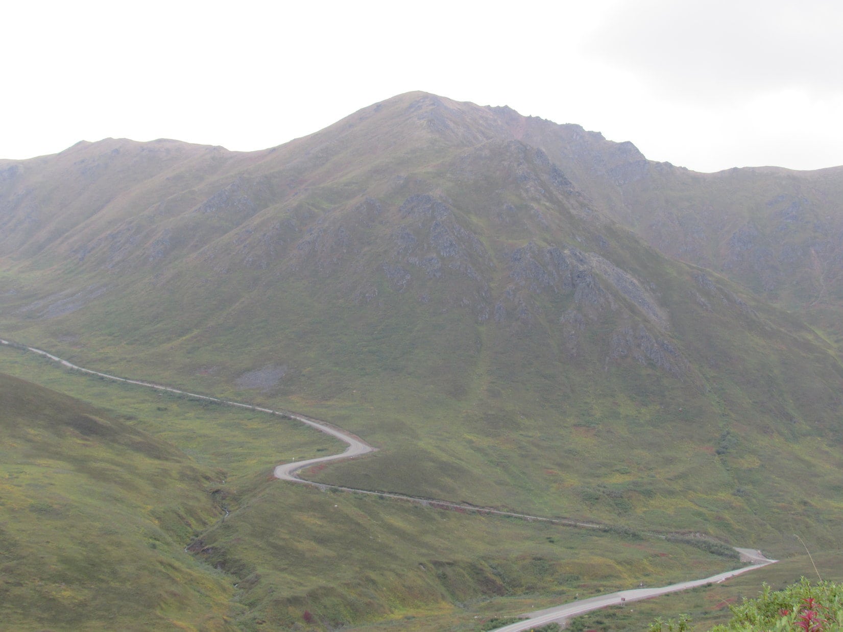
The Matanuska Glacier was visible from the Glen Highway. Photo looks SE.Lupe along the Glen Highway with the Matanuska Glacier in the background. Photo looks SE.Toe of the Matanuska Glacier with a little help from the telephoto lens. Photo looks SE.
Conditions improved rapidly as Lupe and SPHP continued E on the Glen Highway. That was great news! Two of Lupe’s peakbagging objectives were coming up soon.
The first was Lion Head(3,185 ft.). Lupe found the road that serves as a trailhead near milepost 106. Beyond a parking area, a closed gate was across the road. A “No Trespassing” sign said AT&T owned the property. No one allowed in without permission from AT&T. Most disappointing.
Surprising, too! SPHP had read online accounts touting the climb up Lion Head for the spectacular views of the Matanuska Glacier. None of them had mentioned an access problem. Several vehicles were parked along the road near the closed gate. Others must be making the hike. SPHP hesitated. Gunsight Mountain was another 10 or 12 miles E. Maybe Lupe should check out Gunsight instead?
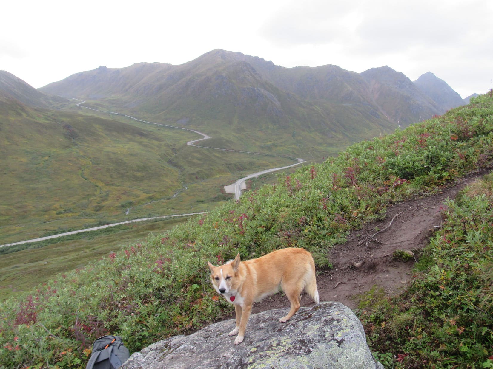
Near milepost 117, Lupe and SPHP stopped at a large empty pullout on the SE side of the Glen Highway. A sign said this was the Camp Creek trailhead. Absolutely no other information was available. Not a soul was around. Gunsight Mountain loomed to the NW right across the highway.
Despite involving 3,400 feet of elevation gain, the climb up Gunsight was supposed to be easy and straightforward. Was this the trailhead for Gunsight? Except for those tall bushes low down on the mountain, the climb looked easy enough whether there was a trail or not. SPHP grabbed the backpack, crossed the highway, and Lupe was on her way! (1:29 PM, 54°F)
Five minutes after Lupe started her assault on Gunsight, SPHP was beating a retreat. Those tall bushes were an impassable jungle! There certainly didn’t seem to be any trail. Lupe had no choice, but to follow SPHP back to the G6. So far, Lupe’s day had been nothing but frustration. Another mile E, near milepost 118, her luck changed.
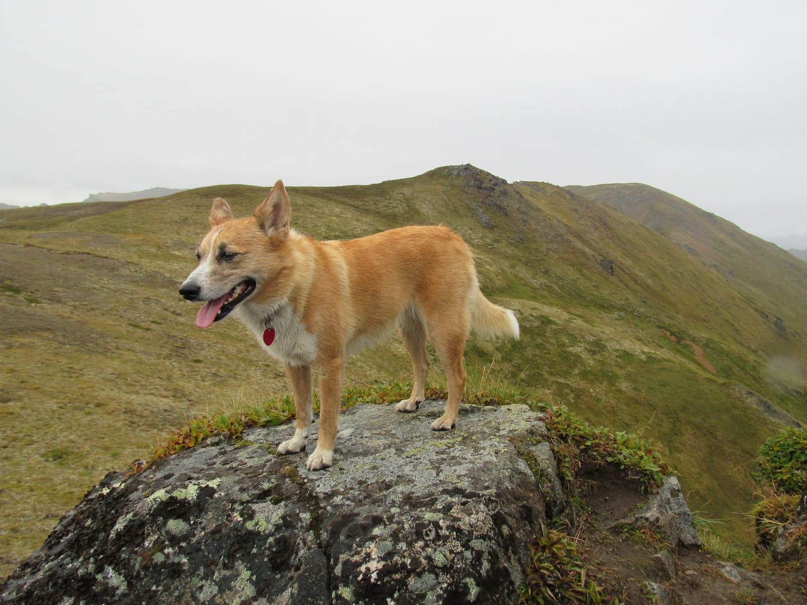
A green street sign read “Trailhead Access Road”. A short road on the NW side of the highway led to a large paved parking lot. A posted map showed several trails in this area, including one leading to Gunsight Mountain(6,441 ft.). Twenty minutes after launching her first attack on Gunsight, Lupe set out again.
An old road led to an ATV trail that climbed rather steeply at the start. Things leveled out after 200 feet of elevation gain. The ATV trail had turned N. Lupe reached an intersection where a small pond was a short distance ahead.
The ATV trail led Lupe to an intersection where this small pond was in view. The long ridge in the background is part of Syncline Mountain(5,471 ft.). Photo looks N.
Lupe didn’t need to go N. She turned W on another ATV trail leading toward Gunsight Mountain. A huge, colorful hillside, was ahead. The top of Gunsight Mountain appeared above it in the distance.
Lupe turns W on the ATV trail leading toward Gunsight Mountain. A huge, colorful hillside was ahead.
The ATV trail was full of big, muddy potholes, and soon gave out. A single track trail led into the bushes which dominated the landscape. It too, disintegrated before long. A bewildering maze of little trails went in all directions, appearing and disappearing in no discernible pattern. Lupe thought this was great! She could prowl around unseen until she was almost upon SPHP.
The bushes down where Lupe had made her first brief assault on Gunsight had towered over SPHP. They had strong, thick branches. Fortunately, the bushes here were only chest high on SPHP. It was possible to push through these smaller bushes along the myriad of little trails, though it was preferable to follow the occasional strips of open ground between them whenever possible.
Getting to the top of this first big hillside took a while. The climb gradually steepened along the way. On the bright side, the open ground between bushes started to dominate as Lupe gained elevation. If there was any organized trail up this long hill, Lupe never found it. During short rest stops, SPHP consumed wild blueberries, which grew in great profusion on the hillside.
By the time Lupe reached the top of the big, colorful hillside, the bushes had disappeared entirely. Only the low, delicate plants of the tundra remained. Lupe already had some fabulous views from here.
Lupe already had fabulous views from the top of the first, long, colorful hillside. Photo looks SE.Looking SW down the Matanuska River valley.Looking back down the long, colorful hillside toward the Gunsight Mountain trailhead near the Glenn Highway. Photo looks E.
The best route to the top from here was obvious. Lupe headed W across a broad area of fairly level tundra toward the NE ridge of the mountain. She even lost a little elevation along the way, before the climb resumed.
Lupe on her way W from the top of the long, colorful hillside toward Gunsight’s NE ridge seen on the R. She would stay on the near side of the ridge, especially as she neared the summit. Photo looks WSW.
Lupe was still on her way up toward Gunsight’s NE ridge, when suddenly there was a voice coming from above. A young woman was cheerily hailing Lupe and SPHP as she hiked down the mountain. SPHP hadn’t even seen her. Her name was Laura. She was here in Alaska visiting friends who had to work today, so she had just trotted on up to the top of Gunsight Mountain for something to do.
Laura was from Montana, which made her practically a neighbor to Lupe. She was very friendly. Was the guy following Lupe and SPHP part of the group? SPHP turned around. There was someone coming! He was still over toward the top of the long, colorful hillside, but heading this way fast. No, Lupe and SPHP had never seen him before.
Lupe with Laura from Montana. Laura had already been to the top of Gunsight Mountain. She was on her way down when she spotted Lupe and SPHP coming up.
Laura and SPHP chatted pleasantly for a few minutes, before she went onward. A few minutes later, she could be seen talking to the guy who was hot on Lupe’s trail coming up. Meanwhile, Lupe reached the NE ridge. Staying on the less steep SE side of the ridge, Lupe and SPHP continued toward the summit.
Lupe reaches the NE ridge. Photo looks SW.
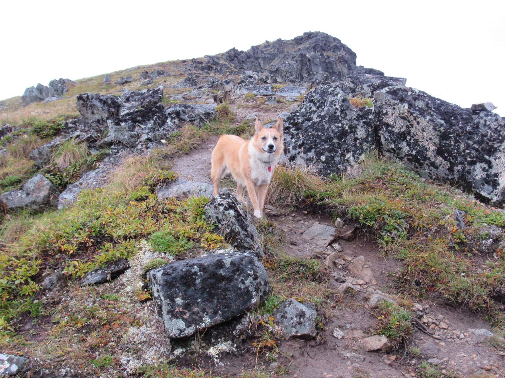
Within a few hundred feet of the summit, the tundra finally gave way to a long, scree slope. During the fairly steep ascent up the scree, the guy who had been following Lupe overtook SPHP. He promised to save Lupe and SPHP good seats with a view at the top.
Lupe on the long scree slope leading to the summit. Photo looks W.
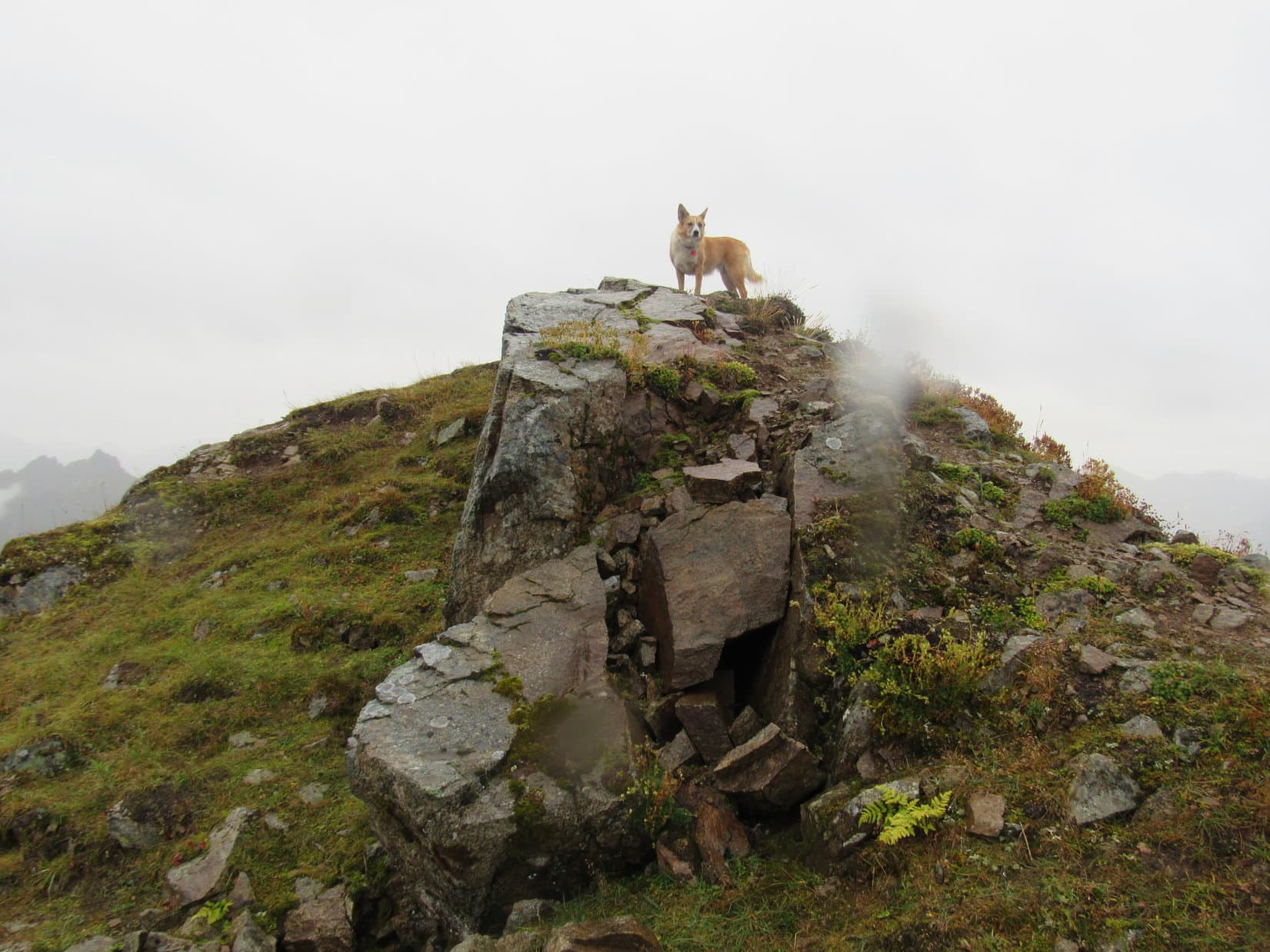
Coming up the easy, broad E slopes of Gunsight Mountain, SPHP had come under the impression that the summit might well be a large plateau, with plenty of room for Lupe to run around. However, when Lupe reached the top of the scree slope, the mountain simply ended. On the other side of the little summit ridge was a gaping chasm.
Standing out at the very end of a small, narrow prominence, surrounded on 3 sides by nothing but air, was the guy who had promised to save Lupe and SPHP good seats with a view. He stood on the brink of destruction at the chasm’s edge surveying the spectacular views, as calmly as any mountain goat might to whom it was all old hat, part of a daily humdrum routine.
His precarious position made SPHP nervous for him, but he calmly walked over to greet Lupe and introduce himself to SPHP. His name was Luke Hall. He was originally from Sidney, Australia. Luke had left Sidney 3 years ago. Since then, he’d worked for a while in Banff, Canada and London, England, and a few other places around the globe. At the moment, Luke was in the middle of an already months long trip exploring and climbing peaks in Alaska.
Lupe meets Australian globe-trotter Luke Hall at the summit of Gunsight Mountain. Photo looks SW.Lupe at the summit. SPHP had expected some kind of broad plateau up here where Lupe could run around. Instead, Lupe arrived to find huge cliffs, chasms, and jagged knife-edge ridges. Photo looks NW.
Wow! Sounded like Luke was adventure personified! Lupe, Luke and SPHP spend 30 minutes together on Gunsight. A lot of chatting, comparing notes, and taking photos went on. Luke had been to Berg Lake in Mount Robson Provincial Park in Canada. Lupe had been there on her Summer of 2013 Dingo Vacation, too. Luke and Lupe had both been to several other places, among them Sukakpak Mountain(4,459 ft.), N of the Arctic Circle.
Luke was surprised to learn that Lupe had made it to the top of Sukakpak. He had been there a couple of weeks ago. He’d made it very high up on the mountain, but hadn’t found the route to the summit. Lupe and SPHP shared how Lupe managed to get there.
Of course, as long as Luke had already been exploring Alaska, he’d seen a lot of places Lupe hadn’t. There was so much to talk about! Fun times, but it was getting to be evening, and this was, after all, the top of a mountain in Alaska. Luke was wearing shorts. Not too surprisingly, he started getting cold standing around. He needed to get moving again, so good-byes were said, and Luke started down the mountain.
Luke and Lupe on Gunsight Mountain. Luke had certainly kept his promise to save Lupe a seat with a view! Photo looks SW.Peaks over-looking the Matanuska Glacier, portions of which are in view in the valley below. Photo looks SW using the telephoto lens.Looking WSW. Part of the Matanuska Glacier in view on the lower L.Luke Hall starts down the mountain after a fun half hour with Lupe at the top. Note the actual patches of blue sky and sunshine! Photo looks ENE.
After Luke departed, Lupe and SPHP spent another 20 minutes at the summit. The views were tremendous in every direction. The day had started discouragingly, but was ending on a literal high note here with Lupe at the top of splendid Gunsight Mountain!
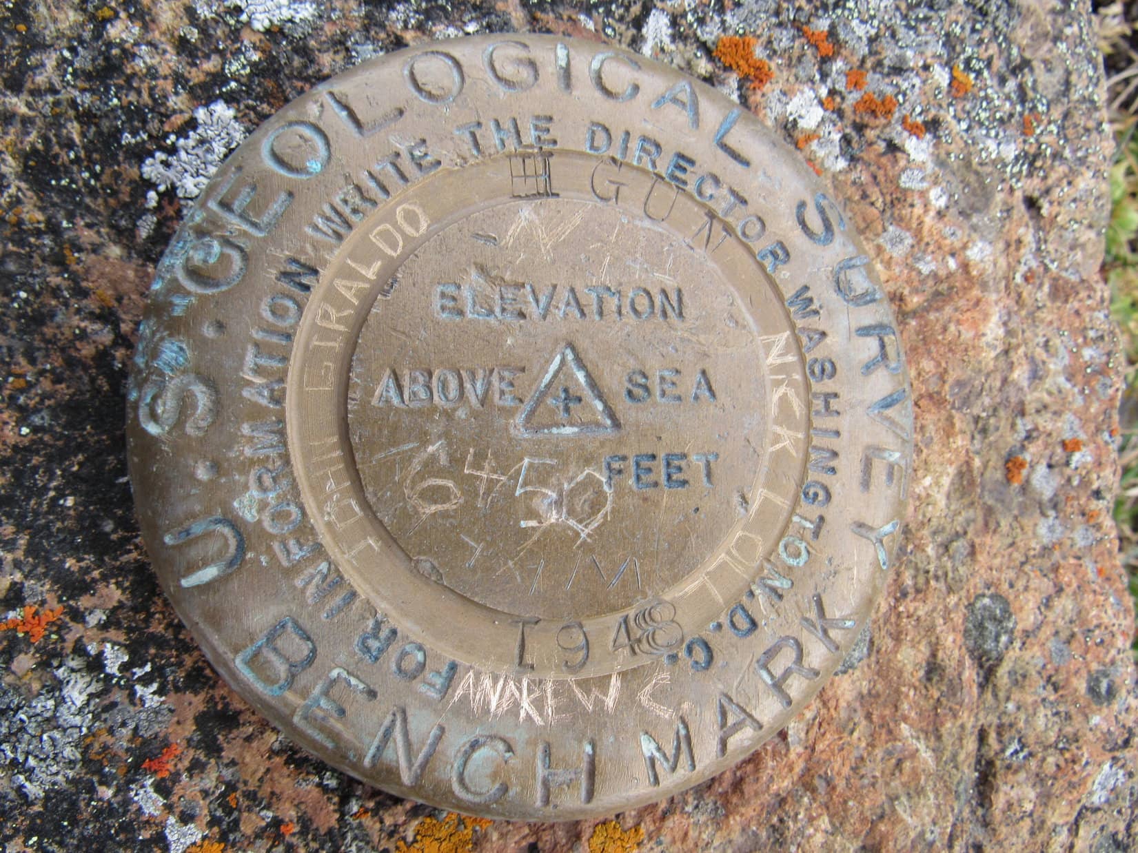
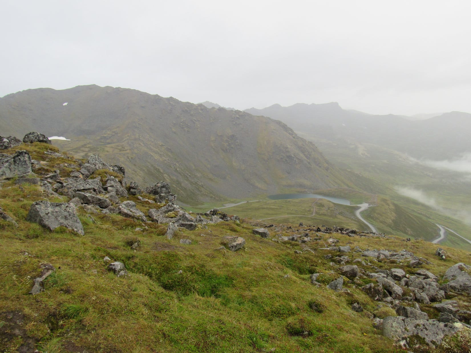
Looking SW along the length of Sheep Mountain(6,223 ft.)(R). Part of the Matanuska Glacier(L) is in view in the distance.Sheep Mountain using the telephoto lens. Photo looks SW.Looking N.Looking SSW. The weather was still stormy looking toward the SW.South Fork of the Matanuska River. Photo looks SSE using the telephoto lens.Big patches of blue sky were appearing off to the E, the first blue sky Lupe had seen in days. Trail Lake is the largest lake in view on the lower R. The Gunsight Mountain trailhead(Center) is barely above the bottom edge. Photo looks ENE.Looking N again.So many mountains were in view from Gunsight! The mountains to the S were high enough to block a view of what lay beyond them. Off to the N, however, range after range could be seen receding to the horizon. This photo looks NNW using the telephoto lens.Looking over Gunsight Mountain’s summit ridge at the gaping chasm to the SW. Sheep Mountain is on the R. The Matanuska River is on the L flowing toward the more distant Matanuska Glacier. Photo looks SW.Wondering if Lupe found the Gun survey benchmark? Here ya go!Looking NW.
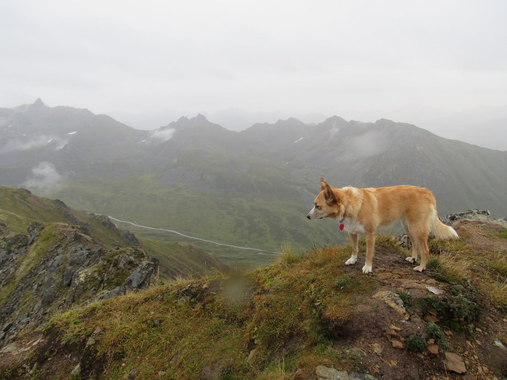
After nearly an hour at the top, Lupe started back down the NE ridge. The evening and surroundings were incredibly beautiful. Most encouragingly, the patches of blue sky and sunshine which had started appearing on Lupe’s way up seemed to be spreading.
Lupe comes back up along the NE ridge to see what’s keeping that slowpoke SPHP. Photo looks NE.
Luke had said he was planning on going to Anchorage and the Kenai peninsula. Maybe Lupe should, too! Maybe the weather was going to improve, and Lupe wouldn’t have to miss out on all the fun that had been planned there. She was only an hour’s drive E of Palmer. Lupe could climb Lion Head tomorrow, and then return to Palmer! It was too soon to leave Alaska, if Lupe didn’t have to.
Although the plan seemed to change with each passing cloud, these happy thoughts accompanied Lupe and SPHP as they took their time on the descent. The long, colorful hill was easier descending than ascending. It was possible to see the pattern of the open areas between the bushes from above, which made it easy to avoid the worst of the bushes. Of course, Lupe thought the bushes were fun, but she didn’t mind being able to run in the open, too.
A tired, but happy American Dingo arrived back at the G6 (9:29 PM). This had turned out to be a great day after all. Maybe things were looking up. Tomorrow, Lion Head!
Even standing right next to the marker, the numbers on it were so faded SPHP could barely make them out. 313.1G. Excellent! No doubt about it now, this icy dirt road leading into the trees was a USFS Road. Come on out, Loop, this is it! Lupe was out of the G6 in a flash (8:58 AM, 39°F). She thrashed around rolling on the ice in her excitement and desire to cool off.
Most of the land right along Carroll Creek Road (County Road No. 313) was privately owned in this area, but SPHP’s old USFS map did show national forest land coming right down to Carroll Creek Road in a few places. Finding USFS Road No. 313.1G meant Lupe had national forest access around the private property nearby. She could get to Peak5360.
Much of the snow that had been in this vicinity a week ago had melted. What was left had turned to ice on No. 313.1G, making it quite slippery. Off road, patches of crusty, crunchy snow lingered in shady spots.
The snow that had been in this vicinity a week ago had turned to ice now on USFS Road No. 313.1G. Photo looks N.
Peak 5360 was another of the series of peaks in the southern Black Hills that Brian Kalet had added to the Peakbagger.com data base last spring. On recent expeditions, Lupe’s adventures had been focused on climbing these Brian Kalet peaks. She now had a good start on visiting all of them. A successful summit of Peak 5360 would “X” another one off the list.
Peak 5360 was only 0.67 miles N as the crow flies. Lupe would have to go more like a mile to actually reach the summit. No. 313.1G started out curving across the lower end of a draw to the NE. It then went around the SW end of a forested ridge before turning NE. Here, Lupe already had a view of Peak 5360 to the N beyond a field of private property.
After following No. 313.1G around the SW end of a forested ridge, Lupe could see Peak 5360 ahead beyond a privately-owned field. Photo looks N.Peak 5360 from the S.
Displaying limestone cliffs at the SW end, Peak 5360 looked like it was probably easiest to climb from the NE. Lupe followed No. 313.1G up the valley. After the road got beyond the end of the private field, Lupe came to two intersections in rapid succession. At the second one, she left No. 313.1G to continue NE on No. 313.1H. She hadn’t gone far at all before reaching a fence with a “No Trespassing” sign.
SPHP checked the USFS map again. Yes, a very narrow strip of private property within the national forest extended farther up the valley from here. Lupe ought to be able to go around it easily enough. SPHP led Lupe NW directly toward Peak 5360. Sure enough, the fence ended shortly after reaching the trees. Lupe turned NE again.
As she got closer to the NE end of the mountain, Lupe started climbing. She had already gained a fair amount of elevation by the time she was able to turn SW to tackle the steepest part of the slope leading to the summit. The remaining snow was getting soft and starting to melt, making things slick for SPHP. The Carolina Dog had no problem, though. She was rapidly approaching the small limestone outcroppings near the top of the mountain.
The snow was starting to melt and make things slippery as Lupe reached the steepest part of the climb up the NE slope. The snow was no problem for her. Soon she could see the limestone rock outcroppings just below the top of the mountain ahead.Lupe at the base of the limestone cap of Peak 5360. Fortunately, the line of rock was discontinuous here at the NE end of the mountain. Lupe had no problem finding an easy route to the top. Photo looks SSW.
The exposed limestone cap at the NE end of Peak 5360 was not thick or continuous enough to create a solid line of cliffs. Lupe had no problem reaching the top of the mountain. The mountaintop was heavily forested, but she had good views from an opening looking NE.
Cicero Peak(6,166 ft.) (L) from the NE end of Peak 5360. Photo looks NE.Black Elk Peak(7,231 ft.) (L). Photo looks NNE using the telephoto lens.
Now that she had made it up here, it was time for Lupe to explore the top of Peak 5360 to find the true summit. The summit ridge extended another 0.125 mile to the SW, so the high point might be some distance away.
From here near the NE end of the mountaintop, Lupe set out to find the true summit of Peak 5360. Photo looks WSW.
As it turned out, Lupe didn’t have far to go. The true summit was only 100 feet from where she’d reached the top of the mountain’s limestone cap. Brian Kalet had marked the true summit on Peakbagger.com as being close to the NE end of the mountain. Brian was absolutely correct.
A dead tree had fallen over right at the actual summit, and made a great prop from which Lupe could claim her 1st peakbagging success of the day.
Lupe stands on the fallen dead tree at the true summit of Peak5360. Photo looks NE.Amid a dense forest, the gnarly roots of the fallen dead tree were the most scenic thing in view from the true summit.
Simply because she had reached the true summit of Peak 5360 so quickly didn’t mean Lupe was done here. Loop was ready to explore the entire summit area to see what else she might discover. Two ridges converged at the true summit. The shorter one went W, while the longer one went SW. Lupe went SW first.
The SW ridge varied from 50 – 200 feet wide. Although the ridge was fairly level, Lupe lost elevation steadily as she conducted her exploration. From cliffs along the SE edge, Lupe often had nice views in that direction, but the forest hid everything to the NW.
Explorer Lupe midway along the SW ridge. Photo looks back to the NE in the direction she was coming from.Exploring the SW ridge. Photo looks SW.
Lupe had lost significant elevation by the time she reached the cliffs at the end of the SW ridge. Unsurprisingly, the best views were to the SSW. Lupe could see both Parker Peak(4,848 ft.) and Matias Peak(4,780 ft.). Both were far away on the horizon and looked like mere bumps from here.
The best view from the end of the SW ridge was to the SSW. Lupe could see both Parker Peak (on the horizon straight up from the end of her nose) and Matias Peak (also on the horizon, but a little to the R of her tail), but they were so far away they looked like mere bumps from here.Looking down on the Carroll Creek valley. Despite the melting snow, the creek was bone dry when Lupe came by today. Photo looks WNW.
Since the views were better here at the end of the SW ridge than back at the true summit, SPHP suggested taking a short break. Lupe was fine with that for 10 minutes. Then she disappeared. SPHP had to call her. She came running back from the NE. Apparently she had seen enough of this end of the mountain!
At the end of the SW ridge during break time. Photo looks S.
Lupe and SPHP started back up to the NE. When the Carolina Dog was getting close to the true summit again, she turned W to explore the shorter W ridge. This was the only part of the mountain with decent views toward the N or NW. Lupe saw both Sylvan Hill(7,000 ft.) and Thunderhead Mountain(6,567 ft.), but they were quite a long way off.
Lupe’s explorations of Peak 5360 were now complete. She returned briefly to the true summit before heading back down the NE slope. She retraced her entire route back to the G6 (11:12 AM, 46°F).
On USFS Road No. 313.1G again on her way back to the G6. Photo looks SSW.
Lupe wasn’t done with Brian Kalet peaks yet today. Another one, Peak 5240, was her next destination. Peak 5240 is nearly 4 miles SE of Peak 5360 on the opposite side of the little town of Pringle. Ordinarily that would have been close enough for Lupe to consider simply exploring a route to it through the hills, but the USFS map showed a lot of private property in the Pringle area. Lucky Lupe was going to get a ride over to Peak 5240 in the G6.
That was fine with the American Dingo! She kept a keen eye out for cows and horses to bark at along the way. She saw several on the way to Pringle, and hit the jackpot when she got there. A whole herd of black cattle was grazing SE of the intersection of Hwy 385 and Hwy 89. Peak5240 was close by, in full view beyond the herd.
Peak 5240 is only 0.67 miles SE of the small town of Pringle. It is clearly visible from the junction of Hwy 385 & Hwy 89. Photo looks ESE at the mountain from Hwy 89 less than 0.5 mile S of Pringle.
The old USFS map made it look like there was national forest access to Peak 5240 starting less than 1 mile E of Pringle on the S side of Hwy 385. A possible USFS road shown on the Peakbagger.com topo map was nowhere in evidence, though, when SPHP drove by. Quite a bit of private property was in the area.
In fact, an apparently long-established commercial business, the Pringle Bed & Breakfast resort, sat on fenced land S of Hwy 385 where SPHP had expected to find the national forest. The Pringle Bed & Breakfast looked affordable to begin with, and they were advertising winter rates. SPHP was in a generous mood. Did Lupe want to go in for a luxurious, comfy snooze and hearty, nutritious breakfast?
Oh, you’re a riot, SPHP! No, I’m not this tired or hungry!I’ll get you for this! Yeah, some day my fans will be reading “SPHP went missing mysteriously on Expedition No. Blah, Blah”.
SPHP still thought the land the Pringle Bed & Breakfast sat on was national forest ground, but the expected access road didn’t seem to exist and there was nowhere to park. Maybe there was access from the W? SPHP drove back W to Shirttail Canyon Road and turned S. After passing by several private properties, a USFS marker appeared near the start of a dirt side road. Lupe was in luck! SPHP parked the G6, and Lupe was back in business (11:41 AM, 47°F).
The USFS road led up the W slope of Peak 5240 through an open forest of Ponderosa pines. It soon ended at the old Townsite Mine, where a couple of signs indicated someone from Oklahoma had recently staked a new mining claim. Lupe found nothing else here other than the big scar in the hillside left by the original mining operation. She did have quite a good view back toward Pringle to the NW.
Lupe arrives at the historic Townsite Mine on the upper W slope of Peak 5240. It is historic simply because all defunct old mines are historic, in case you hadn’t ever noticed before.From the Townsite Mine, Lupe had an unobstructed view of Pringle, SD. Photo looks NW.Other than this big gash in the W side of Peak 5240, Lupe found nothing else at the old Townsite Mine. Photo looks N.
It doesn’t take a Carolina Dog long to look at a hole in the ground, even if it’s a fairly big one. Lupe left the Townsite Mine going a little S before turning E. She had to make her way up a short, fairly steep slope, but quickly reached the top of a limestone outcropping. Lupe stopped briefly here for a look at the already great view to the SSW.
The view from here was similar to the one Lupe had from the SW ridge on Peak 5360, but was more open and panoramic. Loopster could see Parker Peak(4,848 ft.) and Matias Peak(4,780 ft.) again. They were still far away, but a little closer than before.
Coming up Peak 5240 from the SW, Lupe reached the top of this limestone outcropping where she had a great panoramic view to the S. Still appearing as little bumps on the horizon, Lupe saw Matias Peak (straight up from her tail end) and Parker Peak (L of Center). Photo looks SSW.Another look SSW. Parker Peak is now near (Center) on the horizon.Parker Peak (R) through the telephoto lens.
The rest of the climb up Peak 5240 was only moderately steep. At the top of the mountain, one medium-sized rock stood out as being the true summit of Peak5240. Lupe stood on it to claim her 2nd peakbagging success of the day, striking a somewhat dramatic pose. There was little doubt she was merely following a tradition already established by Brian Kalet.
Lupe poses dramatically at the true summit of Peak 5240! Hwy 385/89 N of Pringle can be seen in the distance. Bear Mountain(7,166 ft.) is on the far horizon. Photo looks NNW.At the true summit. Photo looks WNW.
Near a cairn E of the true summit, Lupe found a survey marker, but it seemed to have more to do with a section line than anything having to do with Peak 5240. The top of the mountain formed a ridge running E/W. The ground was close to level for about 200 feet in this direction. Lupe had surprisingly good views in most directions except to the W and NW, where pines blocked the view toward Pringle.
Looking down the S ridge from a point E of the true summit. Photo looks S.View to the NE.Looking SE. A lot of forest had burned in this direction.
After looking at the views from the E end of the summit, Lupe and SPHP took a break over toward the W end. The trees here provided welcome shade. Lupe wasn’t really hungry yet, but she stayed close by while SPHP munched an apple.
The view down the S slope was lovely. On the horizon was a distant blue ridge that might be part of the Seven Sisters Range(4,420 ft.), where Lupe hopes to visit some more Brian Kalet peaks in the relatively near future. SPHP must have been daydreaming and munching away for a while. Suddenly an American Dingo was right there, demanding an explanation.
Just how long does it take you to eat one crummy apple, anyway? Can we go yet?
Lupe was ready for action! OK, OK! SPHP finished the apple. Lupe cooperated with SPHP for one last photo looking down the S slope. She returned briefly to stand atop the summit rock one more time. Then she headed down the S slope to continue her exploration of Peak 5240.
Looking at the lovely view down the S slope from the break area a little W of the true summit. Photo looks SSE.The high points along the distant blue ridge at Center and to the L may be part of the Seven Sisters Range S of Hot Springs, SD. Photo looks SSE using the telephoto lens.
Lupe went all the way down to the drop-off at the bottom of the S slope. Although she had lost a fair amount of elevation, she still had a great panoramic view.
Lupe near the drop-off at the lower end of Peak 5240’s S slope. Shirttail Canyon Road is the dirt road below on the R. Beyond it, Hwy 89 curves away to the W. Matias Peak is the highest dark hill seen L of Center near the horizon. Photo looks SW.Looking N back up the S slope.
Lupe’s investigations on Peak 5240 were now complete. She left the mountain, stopping by the Townsite Mine one more time along the way. Soon she was back at the G6 (1:04 PM, 47°F).
More than 4 hours remained before sunset. Lupe had run out of Brian Kalet peaks to explore near Pringle. However, while Loopster had been climbing all the Brian Kalet peaks farther N in recent weeks, SPHP had noticed a mountain not in the Peakbagger.com data base that Brian had somehow missed. Buckhorn Mountain(6,330 ft.) was just N of Custer, SD.
Lupe had seen Buckhorn Mountain from Peak6181 only a few weeks ago. It looked like a fairly impressive peak which might have some pretty sweet views from the top. The Custer area, especially to the N, is rugged territory for the Black Hills featuring lots of huge granite rock formations. SPHP wasn’t even certain if Lupe could get to the top of Buckhorn Mountain, but she was about to find out!
After driving to Custer, SPHP parked the G6 again at the intersection of Hwy 89 and USFS Road No. 362, about a mile N of Hwy Alt 16 (1:33 PM, 45°F). Buckhorn Mountain was only 1.5 miles to the NW.
On the first half of the trek to Buckhorn Mountain, Lupe followed USFS Road No. 362. The road wound NW through a forest which had been thinned by loggers fairly recently. Lupe liked the open forest, and trotted along on or near the road sniffing happily. She gained elevation steadily, but only gradually, on the way. She passed by a private drive on the N side of the road, but No. 362 continued on beyond it.
At the high point on No. 362, Lupe found an intersection. From here, No. 362 went W starting downhill. USFS Road No. 362.1C went N. By now, Lupe was very close to the end of the part of the forest the loggers had thinned. Buckhorn Mountain’s thickly forested SE ridge came right down to No. 362.1C nearby. Lupe took No. 362.1C going N, but arrived almost immediately at a gate barring the road. A sign said she had reached private property.
Lupe didn’t need to go any farther N anyway. Time for the American Dingo to begin her ascent of Buckhorn Mountain! Lupe and SPHP plunged into the forest, starting up the SE ridge.
The climb was really fun! It was steep, but not too steep. At first the forest was the only obstacle to navigate, but very quickly Lupe began coming to granite rock formations along the top of the ridge. The higher up Lupe went, the more the rock outcroppings grew in size. At any moment Lupe might come to a wall of solid rock preventing further advance along the ridge, but she didn’t. Each time that kind of situation seemed to be developing, Lupe found an easy way over, around, or through.
Climbing Buckhorn Mountain’s SE ridge, Lupe came to many interesting rock formations along the way. This one has a hole in it near the top. Photo looks SSE.
SPHP knew that Lupe would eventually come to an intermediate high point, sort of an ESE shoulder of the mountain. The shoulder area had some towering granite at the top. It was the first area of real concern. Would Lupe be able to get past this area without having to lose a bunch of elevation going around it?
A wall of rock 40 feet high appeared ahead. Lupe’s prospects weren’t looking too good, but she kept climbing right up to it. The luck of the Dingo held. Looper found an easy route around the NE side of the rock formation. She was past the ESE shoulder. Nothing to it!
Lupe alongside the rock formations of the ESE shoulder of Buckhorn Mountain. She has already made her way around the NE (L) side of them. Photo looks SE.Lupe below the rocks of the ESE shoulder. Photo looks SE.
Now that she was beyond the ESE shoulder, Lupe could see the top of Buckhorn Mountain ahead. It was still a bit of a climb, but wasn’t that far away!
Now that she was past the ESE shoulder, Lupe could see the top of Buckhorn Mountain ahead. It wasn’t that far away!
Lupe lost only a little elevation traversing the saddle from the ESE shoulder to start the remaining climb up the E slope of the mountain. The forest in the saddle had been thinned by loggers. SPHP staggered through all the annoying slash the loggers had left behind. Before reaching the end of the slash, Lupe was already climbing again.
It still wasn’t clear if Lupe would be able to reach the top of Buckhorn Mountain or not. The final climb had stretches near the top which were even steeper than before. SPHP had to grab onto rocks and trees in some places to get up. None of this was difficult or scary – just a little light scrambling, but with snow and some deadfall timber around, it was slow going.
Near the top, suddenly the ridge was much flatter and easier than before. Lupe and SPHP went W making rapid progress. High rocks appeared ahead. SPHP’s heart sank. There was no way Lupe could reach the top, at least not from what SPHP was seeing from this direction. The rocks were nearly vertical and way too high.
Nothing to do, but check it out. Lupe worked her way around the N side of the rock formation, and found herself in a saddle between it and another rock formation to the N. It still didn’t look like Lupe would be able to climb up the first rock formation. So disappointing! The rocks to the N looked easier, so Lupe went that way first.
The rocks extended farther N than SPHP had seen at first. Lupe kept climbing along a surprisingly easy route. As she reached the N end, SPHP looked back and saw that she appeared to be every bit as high as the highest rocks to the S! In fact, the very highest rocks at the N end looked like they might even be slightly higher. Lupe had reached the true summit of Buckhorn Mountain(6,330 ft.)! Easy as pie in the end!
Lupe reaches the summit of Buckhorn Mountain. Easy as pie in the end! Photo looks E.Lupe at the top of Buckhorn Mountain. These rocks at the N end are the true summit in SPHP’s opinion, although it is a very close contest with the first high point Lupe had seen roughly 200 – 300 feet farther S. Photo looks N.
The views were fabulous! Poor Brian Kalet had really missed out by not getting to this peak. Lupe had a sweeping 180°+ panoramic view everywhere to the N. The Carolina Dog could see lots of the highest, most rugged territory and peaks of the Black Hills from here.
Thunderhead Mountain(6,567 ft.) is almost always referred to locally as Crazy Horsedue to the memorial being carved into the mountain. Photo looks N using the telephoto lens.Sylvan Hill(7,000 ft.)(L) and Black Elk Peak(7,231 ft.)(R). Photo looks NNE.Bear Mountain(7,166 ft.) (L of Center) is the highest point along the far ridge. Photo looks NW.
Lupe decided to celebrate her successful ascent of Buckhorn Mountain by taking a break. She feasted on Taste of the Wild, then curled up for a rest at a comfy spot in the warm sunlight.
Lupe decided it was time to put a little Taste of the Wild in her tank.Relaxing in the sun. Photo looks NNE.
While Lupe relaxed, SPHP took a couple of close-ups using the telephoto lens.
Sylvan Hill with some help from the telephoto lens. Photo looks NNE.A closer look at Bear Mountain. Photo looks NW.
After her short rest, Lupe got back up on the true summit at the N end of Buckhorn Mountain again.
Lupe returned to the N summit after her rest break. Black Elk Peak is seen on the R. Photo looks NNE.
The time had arrived to explore the rest of the summit area. Maybe it was possible for Lupe to reach the top of the first rock formation she had come to farther S? If she could, there wouldn’t be any question whether she had reached the true summit of Buckhorn Mountain. The Carolina Dog headed S to check it out.
The top of the rock formation to the S is seen on the R. Photo looks S from a point not too far from the N summit.
It turned out that the S rock formation was really the middle high point on Buckhorn Mountain. Between the trees, another high point could be seen even farther off to the SSW. However, it was clear that the actual S high point wasn’t as high as either the central or N ones were.
From the NW, the middle rock formation didn’t look nearly as daunting as it had from the E. Lupe could probably climb it from the SW!
Lupe near the middle high point. Seen from the NW, it wasn’t nearly as imposing as it had seemed when Lupe originally approached from the E. In fact, it looked like Lupe might be able to get to the top from the SW. Photo looks SE.
A couple of minutes later, Lupe and SPHP were at the top of the middle summit. Getting there was an easy little scramble. The area at the top was all lumpy granite, but Lupe had a little room to move around. From here, she had terrific views to the E. She could see part of the town of Custer to the SSE, and beyond all the way to Northeast Cicero Peak(6,240 ft.).
Loop reaches the top of the central high point on Buckhorn Mountain, the rock formation that had looked too imposing to climb as Lupe first approached it from the E. Photo looks NE.Lupe on the Central high point. Looking back toward the N summit, which was almost in view from here, SPHP really wasn’t certain which was the true summit. Either way, Lupe had now been on top of both. SPHP’s final conclusion was that the N high point is the true summit, but it’s an extremely close contest. It’s entirely possible this is actually it. The difference might be only inches, a foot or two at most.
Having climbed both the N and Central high points now, no matter which one was actually the true summit of Buckhorn Mountain, Lupe had been there. All that was left to do was check out the views from the lower S high point. As Lupe approached it from the N, there seemed to be little prospect of reaching the top. The rocks were vertical.
As Lupe approached from the N, there seemed to be little chance she could get to the top of the S high point. Photo looks S.
Sadly, SPHP didn’t think Lupe could even reach the S end of this rock formation, where there ought to be a sweeping panoramic view. Wrong! Lupe discovered an easy way around the W side that led directly up to a fantastic viewpoint.
From the far S end of the S high point, Lupe had this beautiful view to the WNW. Huge granite formations were close by. Farther off was Atlantic Hill(6,393 ft.) (R), and beyond it were the distant high ridges of the western Black Hills.Lupe at the far S end of the S high point. The town of Custer is seen below. In the distance is Northeast Cicero Peak(6,240 ft.) (Center). Apparently deer (or mountain goats?) like this view. There were lots of what looked like deer droppings near the edge of the precipice. Photo looks SSE.Part of the town of Custer, SD with Northeast Cicero Peak in the distance. Photo looks SSE using the telephoto lens.
Lupe couldn’t get to the top of the highest rocks at the S high point, but reached a point that wasn’t too much lower. It didn’t matter anyway, since the S high point was definitely not the true summit. After enjoying the grand view, Lupe returned to the N end of the mountain. SPHP needed to retrieve the pack, which had been left there.
Thunderhead Mountain (Crazy Horse) (R of Center) again from the N summit. Photo looks N.Black Elk Peak with a little help from the telephoto lens.
After SPHP retrieved the pack, Lupe left Buckhorn Mountain. What a splendid fun climb and summit it had been! Lupe went back to the G6 following the same scenic route she had taken up. Near the wild-looking rock with a hole in it, SPHP found the topo maps on the ground. SPHP had dropped them on the way up.
Fortunately, when the route is obvious, a map isn’t required. Just keep following that curly Dingo tail onward and upward! (5:27 PM, 36°F)
Days 22, 23 & 24 of Lupe’s Summer of 2016 Dingo Vacation to the Canadian Rockies, Yukon & Alaska
8-20-16, 8:00 AM. Gray, gloomy, light rain. Disappointing, but it didn’t matter too much. Lupe was at Byers Lake in Denali State Park in Alaska. She’d spent the last two days exploring fabulous K’esugi Ridge. She’d had a wonderful time, but after dragging back in to the G6 after 3:30 AM last night, both Lupe and SPHP were in real need of a rest day. Even if the skies had been crystal clear and blue, there wouldn’t have been much on the agenda today.
SPHP drove over to pay the $5.00 daily parking fee, as strongly suggested by the official pay envelope waiting on the G6’s windshield upon Lupe’s return last night. Then it was back to the parking lot. Lupe was going to get her $5.00 worth today. Time for more shuteye.
Of course, it would have been nice if the skies had cleared. Although Lupe had been in the Denali State Park area for nearly 3 days now, she still hadn’t gotten a good, clear view of Denali(20,310 ft.). She’d seen the incredibly massive white mountain from an enormous distance earlier, while still close to Fairbanks, but had only caught brief glimpses since.
Nature doesn’t care what might be nice. The clouds did not part. Not even the tiniest speck of blue sky appeared. The dreary, light rain fell sporadically all day. Lupe and SPHP mostly snoozed. Maybe tomorrow Lupe would finally get that superb view of Denali?
8-21-16, morning. See Denali? Hah! Not a chance! The sky had wept all night. Rain was still falling, steadily, and much harder than yesterday. Time to give up on the Denali Dream. Lupe was all rested up now. She had other adventures to get to! Good-bye Denali State Park. Good-bye fabulous K’esugi Ridge!
Rain poured down, as SPHP drove S on the George Parks Highway (Alaska Route 3). The truth was, nearly all of the Alaskan adventures left on Lupe’s list of possibilities were somewhere relatively close to the S coast. The coast had been socked in with rain and fog for weeks. Conditions weren’t likely to be any better along the coast than at Denali State Park. Maybe Lupe’s time in Alaska was drawing to a close?
The sky remained overcast, but the rain ended before Lupe reached Wasilla. Civilization! Lupe and SPHP shared a box of ice cream bars and a couple of cheeseburgers. SPHP killed some time at the laundromat, and taking care of a few other chores. Already 5:00 PM. This day was slipping by, too.
One adventure still seemed like a possibility. If the rain would hold off, maybe Lupe could climb Skyscraper? Less than 1,000 feet of elevation gain was required. The mountain’s summit wasn’t even a mile from Hatcher Pass, a scenic 20 or 30 minute drive NW of Palmer.
Palmer wasn’t far from Wasilla. At Fishhook Junction, a mile N of Palmer, SPHP turned W (L) off the Glenn Highway (Alaska Route 1) onto Fishhook Willow Road. Fishhook Willow Road went W 2 miles then turned N following the Susitna River valley. After a sharp L turn onto Willow Creek Road, SPHP figured Lupe must be getting close to Hatcher Pass. SPHP parked the G6 at a pullout near the Fishhook Trailhead, right off Willow Creek Road.
Conditions weren’t so great. Mist was falling here. Low clouds draped over every mountain peak, threatening to unleash more serious moisture at any moment. If Lupe did make it to the top of Skyscraper Mountain, she might not see anything except fog.
However, Lupe desperately wanted to go. She’d been cooped up in the G6 for nearly 2 days now. The mountain looked only moderately steep, and appeared to be an easy climb. A maze of soft, damp trails wove among low, wet bushes toward the S spine of the mountain. Lupe and SPHP started up.
Glad to finally get out of the G6, Lupe starts up the mountain. Photo looks N.
Everything was going fine. Lupe was having a good time. She’d already gained perhaps 250 feet of elevation, when SPHP paused for a quick breather. So far, so good. Except for that view to the W. Something was wrong over there. A road snaked up the main valley into a side valley, continuing on up to a big saddle even higher than where Lupe was now. How could that be?
Mist turned to light rain, as it all sunk in. That road was the Willow Creek Road going up to Hatcher Pass. It had to be. For pity’s sake! Lupe wasn’t even climbing the right mountain. Skyscraper Mountain(4,825 ft.) was over there! No doubt about it.
Lupe at the highest point she reached on the trail up the wrong mountain. At least she had a good view of Skyscraper Mountain(Center) and Hatcher Pass(L) from here. Photo looks W.Skyscraper Mountain(4,825 ft.) (Center) overlooks Willow Creek Road on its way up to Hatcher Pass. Lupe was supposed to have been climbing Skyscraper along the SW ridge seen on the L. Photo looks W.
Sheesh! SPHP had no idea where this trail Lupe was on went, how far it went, or what mountain Lupe was on. (She was on the 1.2 mile long trail up Marmot Mountain.)
Oh, well. Conditions were deteriorating anyway.May as well call it. Back to the G6! At least Lupe had some exercise and fun. As an added bonus, SPHP finally understood where Hatcher Pass and Skyscraper Mountain were.
Who knew? With a little luck, tomorrow would be a better day. Lupe might be glad her climb of Skyscraper had been postponed.
I’m on the wrong mountain? How can that be? You’re joking, right? SPHP, you come up with the craziest notions! Maybe I’m going to have to take a firmer paw in adventure planning from now on.
Dream on! The G6’s radio said differently. Rain continuing through tomorrow, extending into blah, blah. Enough of that! Outside the G6, the world continued dripping.
8-22-16, morning again. Still heavily overcast, but not raining. Maybe Lupe could climb Skyscraper right now, first thing? SPHP drove up to Hatcher Pass. The pass wasn’t far at all, but conditions were a lot different here. Steady rain, 52°F, a chilly breeze, and fog. Umm, no thank you! When it comes to adventure, Lupe and SPHP are fair weather friends. No need to star in a private episode of Survivor!
Civilization has its advantages. Lupe and SPHP left Hatcher Pass and drove down to Palmer. A roasted chicken was obtained and shared. Lupe gnawed on a rawhide stick for a while, then snoozed. SPHP read. Palmer was overcast, of course, but it wasn’t raining.
Early afternoon. Still no rain in Palmer. Maybe things were better by now at Hatcher Pass? Lupe and SPHP went back up there. No rain until just before reaching the pass, where nothing had changed since this morning. Aggravating. Lupe would just stay here and wait it out. Sooner or later, there had to be a break didn’t there?
Lupe poses near the Hatcher Pass monument during a brief lull in the rain. Photo looks W.
Despite the cold rain, a surprising number of people came and went. Most were well equipped with umbrellas and rain gear. Many took short walks on trails over the gently sloping tundra beyond the Hatcher Pass monument, but few remained in the area for long.
SPHP talked to a couple of guys getting back into their vehicle with Alaska plates. Did they know anything about the long range weather forecast? It was a rental car. They were Germans, but they did know something about Alaskan weather. They’d been in Alaska for 2 weeks and had been going to extremes to try to find a little sunshine.
The Germans said 3 more days of rain were in store here, then it was supposed to clear. As soon as they left Hatcher Pass, they were headed for Anchorage to fly to Nome. Nome was sunny. In 3 days, they would fly back to Anchorage. Now, there was an idea. Lupe could fly to Nome!
Perhaps SPHP lacks imagination. Flying Lupe to Nome on the spur of the moment seemed a bit extreme. No doubt a spontaneous trip to Nome would have been a grand adventure, though!
There were brief lulls, but mostly the rain went on and on. The afternoon ticked away. Lupe had been snoozing, but during a lull in the rain, she finally woke up. She just had to get out and run! Off like a shot, the Carolina Dog flew across the heather until she was a distant speck. SPHP stood in drizzle watching from afar, waiting for Lupe to tire of her big romp and return.
A couple of women walked by with 3 kids. The older woman was telling the children to be careful not to slip on the muddy trail. Moments later, the oldest child slipped and fell in the mud. She started crying. The older woman lost it, and started screaming at the girl. She was glad Michelle was hurt! It served her right for not listening and being careful. Hadn’t she just been told to be careful? Michelle wouldn’t get any help from her!
The obscenity-laden rant went on for several minutes while Michelle cried. The other woman at least helped her back on her feet. Michelle was what, maybe 9 – 11 years old? SPHP was on the verge of going over to have a few choice words with Cruella de Vil, when she finally shut up. The immediate crisis was over. Even so, Michelle’s problems in life were far from over, not by a long shot, if that witch was her mother.
The glorious human race! So capable of both the very best and very worst the planet has on offer. Carolina Dogs are better company – active, friendly, sensible and loyal! Speaking of which, where was Lupe? Here she came, racing back from her romp. She was eager for SPHP to join in the fun. It had only been misting lightly during Michelle’s ordeal. Might as well try Skyscraper now, before things changed.
SPHP drove down to a slightly lower pullout at the base of the informal trail up Skyscraper Mountain. Lupe could hardly wait. As soon as she was out of the G6, she took off again, racing hundreds of feet down the tundra on the other side of the road. She came right back, panting hard, and was overjoyed to see SPHP getting the pack ready.
A volley of raindrops splattered SPHP, but didn’t last long. Yes, raingear was in order. SPHP dug it out of the pack, and put on a green plastic rain poncho. Ready for another attempt. How far Lupe would get was in serious doubt, but at least she would be on the right mountain this time around. Lupe and SPHP started up the slope. (6:20 PM, 48°F)
Start of the trail up Skyscraper Mountain from the pullout along Willow Creek Road near Hatcher Pass. Photo looks N.
The longest, steepest part of the climb came right at the start. Skyscraper is one of those mountains where the top always looks only another 50 feet higher. By the time Lupe reached the first high point, she had already gained 2/3 of the total 950 feet of elevation gain required to reach the summit.
Lupe finally nears the first high point. Photo looks N.
From a rock formation at the first high point, Lupe got her first view of what lay ahead. Not far to the N, an orange windsock floated on the breeze above a broad, rounded ridge. From the windsock, Lupe would have an easy time traveling over gently rising tundra toward a couple modestly higher points along the ridge.
From the rock formation at the first high point, Lupe saw an orange windsock floating in the breeze. The ridge ahead was broad and rounded. Lupe would have an easy time traveling over the tundra here. Photo looks NNW.From the first high point, Lupe saw two modestly higher points ahead along Skyscraper’s SW ridge. Beyond them, she could already see the S end of the summit ridge. Photo looks NNE.
Looking back, Lupe could see Summit Lake on the W side of Hatcher Pass. April Bowl and Hatch Peak(4,811 ft.) on the S side of the pass were in view, too.
Looking back the way Lupe had come, Summit Lake(R) was in view on the W side of Hatcher Pass. Hatch Peak(L) and April Bowl (where the snow is below the peak) were in view, too. Photo looks S.
Lupe checked out the orange windsock, before turning NE to start the easy stroll up toward the next couple of high points. She had a blast running around sniffing and exploring the tundra. By now, Skyscraper Mountain’s entire summit ridge was in view, including the little bump up at the N end where the true summit is located.
Lupe checks out the orange windsock. The first high point she reached is on the L. Hatch Peak(R) and April Bowl are seen in the background. Photo looks SSE.The gentle path to the next modestly higher points. Skyscraper Mountain’s summit ridge is in view L of Center. Photo looks NE.
The path along the higher part of the SW ridge undulated from one minor high point to the next. Through the light mist, Lupe could see mountains in every direction. If it had been a clear day, the scene would have been really gorgeous. Lupe had nothing to complain about, however. She was lucky the rain was holding off for the time being.
Lupe on the undulating SW ridge. Skyscraper Mountain dead ahead! Photo looks NE.The tundra features such amazingly brilliant little plants!
Beyond the minor high points of the SW ridge, the trail lost some elevation heading down to a saddle leading to Skyscraper’s summit ridge. Another steep climb ensued from the saddle, but it was only half as long as the first big climb had been. Soon Lupe was up at the S end of the summit ridge. The Pass survey benchmark was right there.
The Pass survey benchmark was hard to miss at the S end of Skyscraper’s summit ridge. The “P”, “A” and part of the first “S” for Pass can still be made out to the L of the center triangle.
Skyscraper’s summit ridge is nearly level until it reaches a modest bump up at the N end where the true summit is located. The ridge was much narrower than the SW ridge Lupe had come up, especially toward the N end. The true summit was only 150 yards N of the Pass survey benchmark.
Lupe was there in practically no time at all. After days of waiting, success rewarded patience! Congratulations, and the usual paw-shaking ceremony ensued.
Lupe stands next to the Pass survey benchmark. The true summit of Skyscraper is only 150 yards away along the ridge. Beyond Skyscraper’s summit, Bullion Mountain(5,100 ft.) is seen in the distance. Photo looks N.Lupe stands atop the true summit of Skyscraper Mountain! Marmot Mountain(4,770 ft.) is seen beyond Lupe. SPHP believes Microdot(4,900 ft.) is the high point L of Center, and The Pinnacle(5,500 ft.) is the highest point on the far L. Photo looks NE.Lupe on top of Skyscraper. Photo looks ENE.Carolina Dogs are rarely seen on Skyscraper Mountain, but it does happen! Microdot is visible on the L. Photo looks NE.
Mist and drizzle had occasionally given way to light rain on the way up. Lupe was fortunate to have reached the summit of Skyscraper. Conditions might worsen at any moment, so Lupe and SPHP didn’t stay at the summit too long. There was time enough for some photos, and a good look around at what could be seen of the rugged surrounding peaks of the Talkeetna Range.
Lupe stands on a nearby high point while SPHP stands on the true summit. Skyscraper’s summit ridge extends off to the L. The SW ridge Lupe came up is visible to her R. Hatch Peak and April Bowl are in view R of Center. Photo looks S.Looking NNE farther along the ridgeline from Skyscraper’s summit. Bullion Mountain is on the L. The Pinnacle is the highest point seen R of Center. Microdot is on the R.Lupe once again on the summit. Photo looks SW back toward the easy SW ridge she came up.
Time to go. Lupe and SPHP started back S along the summit ridge. In the saddle between the summit ridge and the SW ridge, Lupe met two young guys from Wasilla on their way up Skyscraper. They said the weather was typical of this time of year around here.
Out of curiosity, SPHP asked them what trails/peaks they recommended Lupe save for a sunny day in the area? Reed Lakes was the immediate response. It wasn’t far from here. SPHP had heard of it. Good information. Never hurts to ask the local experts!
Looking S from the S end of Skyscraper’s summit ridge (near the Pass survey benchmark). Hatch Peak and April Bowl are on the L. Hatcher Pass is seen at Center. Skyscraper’s SW ridge leading back down to the G6 is on the R. Photo looks SSW.
A thick fog rolled in as Lupe descended the last little stretch of the steep final slope to the G6. Rain came with it. Back just in time (9:13 PM)! Those poor guys from Wasilla hadn’t looked prepared for this.
Fifteen minutes later they appeared running across Willow Creek Road toward Hatcher Pass, where their vehicle must have been parked. Had they made it to the summit of Skyscraper? Probably, but they couldn’t have been there long enough to enjoy it. Lupe would never know for sure. At least they were back safely, though cold and soaking wet.
Lupe’s Skyscraper Mountain adventure had reached a successful conclusion, despite all the doubts of the last several days. Time to celebrate! SPHP drove down out of the soup back to Palmer. All remaining roasted chicken was devoured, along with a second course of cheese and crackers.
Carolina Dogs love cheese! Lupe always gobbled the cheese first before she would touch the cracker. American Dingoes always go for the gusto, then mop up whatever remains later on. But then, you probably knew that already.
On Skyscraper Mountain, Talkeetna Range, Alaska 8-22-16