Jack Squirrel Peak, Laramie Range, Wyoming (6-19-17)

Day 12 of Lupe’s 2017 Dingo Vacation to the Laramie Range in Wyoming & Beyond!

Lupe could hardly believe her big soft Dingo ears!  Her spine tingled with excitement.  She stared at SPHP in wide-eyed wonder and disbelief.  Was it true?  Was she really on her way to fabled Squirrel Mountain?  Oh, joy!

Not Squirrel Mountain, Loop – Jack Squirrel Peak.

Mountain, peak, what difference did it make?  Loop didn’t know and didn’t care.  She was certain Squirrel Peak would be every bit as fabulous as Squirrel Mountain.  How could it not be?  In fact, the notion that there might be both a Squirrel Mountain and a Squirrel Peak was an exciting idea she’d never even thought of before.

I’m not even certain what a jack squirrel is, Looper.  Maybe a jack squirrel is just larger than ordinary squirrels with a super long bushy tail?  Kind of like a jack rabbit is bigger than ordinary rabbits and has longer ears and legs.

The American Dingo’s eyes grew even bigger.  This was too good to be true!

Oh, I hope you’re right, SPHP!  This is going to be the best mountain ever!  I never should have doubted you.  Your the best friend a Dingo ever had!  This is going to make up for when you forgot the whiskey on Whiskey Peak, and then some.

Well, maybe it would, and maybe it wouldn’t.  SPHP parked the G6 on the S side of County Road No. 710 where it turned W near Silver Tip Creek (10:43 AM, 62°F)Jack Squirrel Peak (8,942 ft.) was only 1.5 miles SSE from here at the S end of the long Eagle Mountain ridge.

Several log and wooden structures were on the other (N) side of County Road No. 710 from where SPHP parked the G6. They all seemed to be abandoned. Photo looks N.

Most of the territory E of here, including Jack Squirrel Peak, was all national forest land.  However, by far the easiest way to the mountain was to head S across a big field N of the confluence of Silver Tip and Bear Creeks.  Though this field was private property, signs on the fence said this land was open to the public for hunting.

We’re hunting jack squirrels, right Loop?

Of course!  We’ll be back soon with passels of ’em!  We’re entirely legit.

I’m not even sure if it’s jack squirrel season.  You’ll vouch for me if anyone objects?

Don’t be ridiculous, SPHP!  It’s always squirrel season, jack or not.  We Dingoes are experts on the subject.  Carry on!  Just point me to Squirrel Peak!

Loop ready to depart for Jack Squirrel Peak (L). Photo looks S.

As excited as she could be, Lupe crossed the big field sniffing madly trying to pick up a scent.  Nearing Silver Tip Creek, she found a dirt road that got her over to the E side of the creek.  Once across, Loop followed the road S beyond Silver Tip’s confluence with Bear Creek.

Lupe heading for the promised land of Jack Squirrel Peak! She’s E of Bear Creek here, and will go up the L side of the low hill directly ahead to enter Hidden Gulch. Photo looks S.

A low hill was up ahead.  Loop left the road to climb it.  Reaching the top, she had a view of Hidden Gulch.

Hidden Gulch from the top of the low hill. High Point 8608 looms above the upper end of Hidden Gulch on the R. Photo looks E.

Hidden Gulch was part of the planned ascent route up Jack Squirrel Peak.  Lupe left the low hill heading E.  She stayed N of a tributary of Bear Creek flowing down the valley.  The intention was for Loop to go all the way up Hidden Gulch to the main N/S ridgeline at a saddle just S of High Point 8608.  At the saddle she would turn SW and follow the ridgeline to the summit.

Things started out OK, but Lupe soon came to a thick forest down by the stream.  The valley was already increasingly rocky, full of boulders and deadfall timber.  The forest appeared impenetrable.  It looked far easier to avoid the forest entirely.  Lupe and SPHP crossed over to the S side of the stream, and began climbing.

The forest had burned on the S side of the valley.  The slope was fairly steep and quite rocky, but the rocks were good-sized and mostly stable.  It wasn’t hard scrambling up among them.

A forest fire had burned the slope on the S side of Hidden Gulch. Though the area was very rocky, the rocks were mostly stable and easy enough to scramble up. Photo looks SE.

The new plan was to keep proceeding ESE up Hidden Gulch as Lupe gained elevation.  She might not have to go all the way to the main ridgeline S of High Point 8608.  Maybe she could manage a more direct route up Jack Squirrel Peak from the N or NW.

The American Dingo climbed and climbed.  The mountain kept getting steeper.  Despite what the topo map showed, the easiest way up always seemed to be more toward the W slope.  Lupe was already quite high by the time SPHP realized how far around to the W she’d gotten.

Lupe was already pretty high up by the time SPHP realized how far she’d drifted around onto Jack Squirrel Peak’s W slope. Huge rocks were everywhere, and the mountain was getting steeper with no relief in sight. Photo looks NW.
On Jack Squirrel Peak’s W slope. The Bear Creek valley is seen on the R. Photo looks S.
Looper looking in vain up Jack Squirrel Peak’s W slope for signs of any jack squirrels. Photo looks E.

Lupe started coming to massive rock formations separated by wide chutes of loose rock and boulders.  She went around the first one or two staying toward the SW.  However, the SW side of the mountain was becoming more intense.  Lupe was finally forced to climb NE up a long chute full of boulders.  Near the top she reached less difficult terrain.

Passing around the SW end of one of the massive rock formations, with another one directly ahead beyond a field of boulders. Photo looks ENE.
Near the upper end of the long chute, Lupe finally escapes the worst of the steep W slope. Photo looks NE.

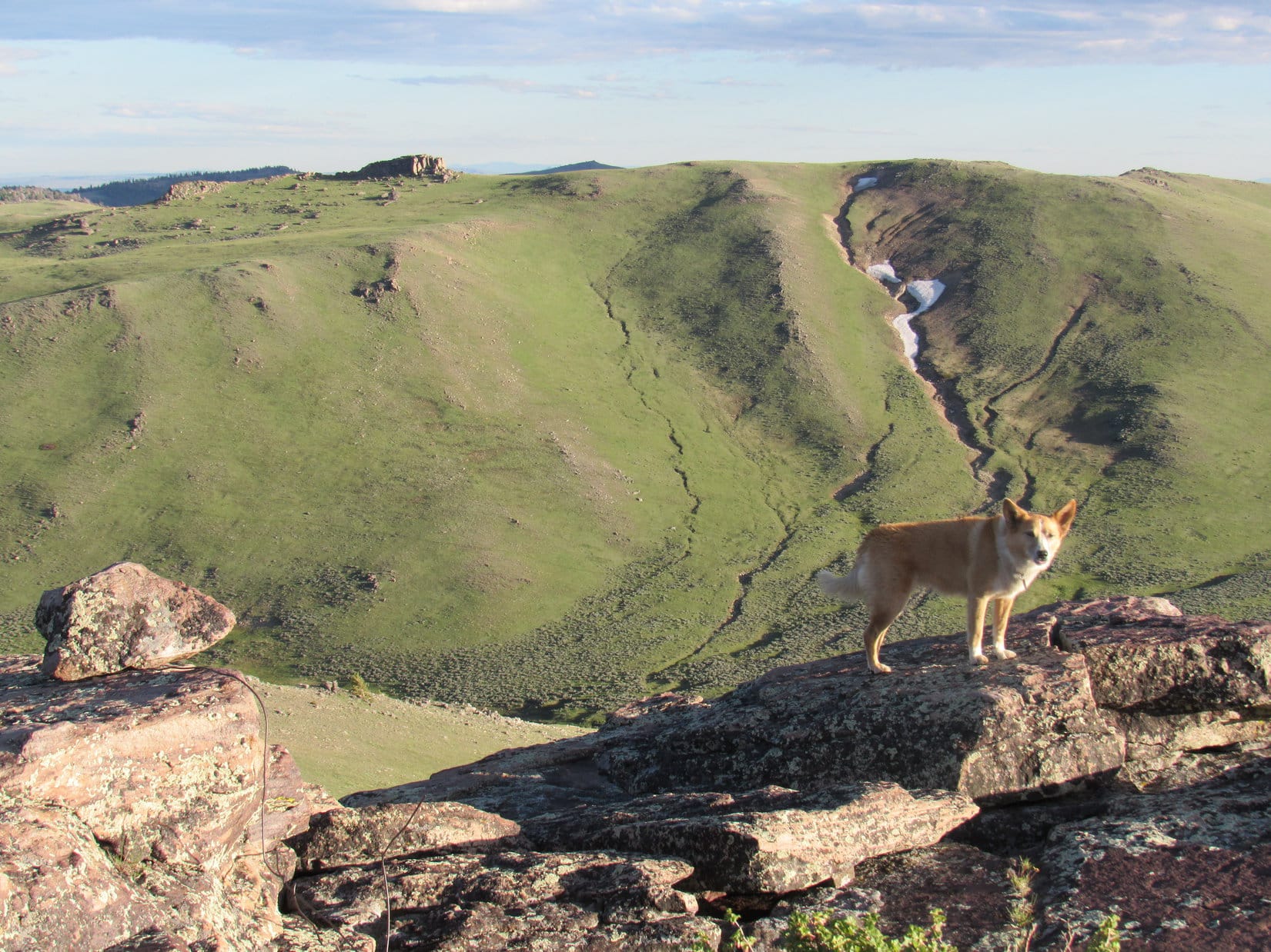
Lupe was certainly getting up in the world!  Off to the NNE she now had a tremendous view of Eagle Peak (9,167 ft.) at the opposite end of the long Eagle Mountain ridge.  Only 10 days ago, Loop had nearly made it to the top of Eagle Peak, but had failed to find a route up onto a vertical rock wall at the top of the mountain.

Lupe was certainly getting up in the world! Off to the NNE she had a tremendous view of Eagle Peak.

Unfortunately, the American Dingo’s ability to get to the top of Jack Squirrel Peak was fast becoming a concern, too.  Although most of the terrain ahead was much easier than where Lupe had just been, a rock formation higher than anything else in sight sat perched high above the opposite side of the long chute she’d just come up.

Was that rock formation Jack Squirrel’s summit?  SPHP hoped not, but feared it might be.  The formation wasn’t all that large, but was at least 20 or 30 feet high.  The part of it in view from here had nearly vertical sides.  Unless the unseen side was a lot easier to climb, Lupe didn’t stand a chance of getting to the top.

On the opposite side of the long chute full of boulders Lupe had just come up, a knob of rock (L) sat perched higher than anything else around. Was that the summit? Failure loomed, if it was. Lupe wouldn’t be able to get to the top of that thing! Photo looks ENE.

Loop and SPHP headed for the rock formation.  When Loop got there, it turned out that the knob of rock was actually more like a narrow ridge.  It was long and skinny, not round.  The E side looked virtually the same as the W side Lupe had seen first.  Loop got up within 20 or 25 feet of the top, but that was as far as she could go.

When Lupe got there, the knob of rock turned out to be more like a narrow ridge. Lupe could get within 20 feet of the top, but no higher. Photo looks SW.

Fortunately, Looper didn’t need to get to the top of this rock formation.  It was only a false summit.  Beyond it, not too far away, was even higher ground.  The Carolina Dog could keep climbing!

Fortunately, the rock formation Lupe had reached was only a false summit. Higher ground was in view ahead. The Carolina Dog could keep climbing! Photo looks ENE.

The higher ground nearby was it!  Just like that, Lupe was at the summit of Jack Squirrel Peak (8,942 ft.).  It hadn’t been all that hard to get here after all.  The last part of the climb had been easy!

SPHP was ecstatic.  Loop seemed shocked by the news.  This was it?  The summit of Jack Squirrel Peak?  She got up on the highest rock for a photo as requested, but her heart didn’t seem to be in it.

Loopster at the top of Jack Squirrel Peak! Photo looks SSE.

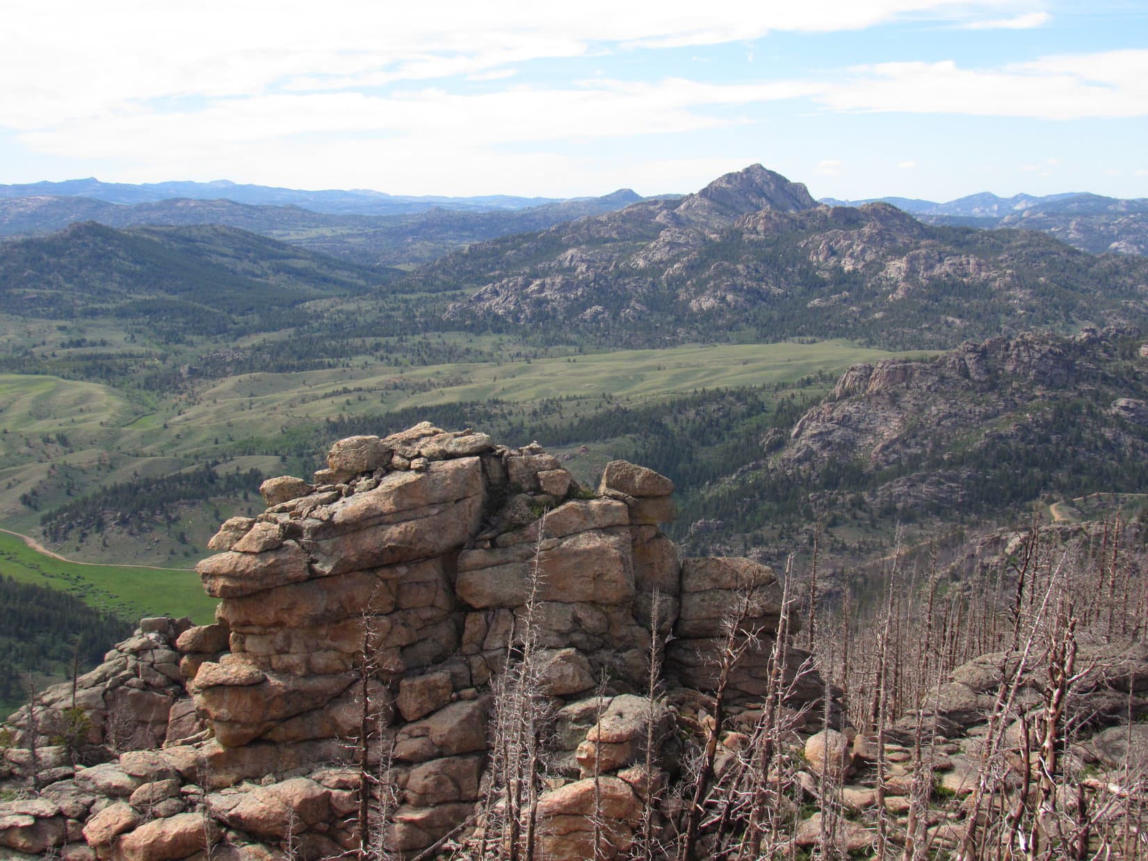
The views were enormous, but the first to capture SPHP’s attention was an impressive wall of rock SSE of the summit.  It towered hundreds of feet above surrounding terrain, and looked virtually as high as the summit where Lupe stood.  In fact, parts of the wall appeared slightly higher.  Wasn’t Loop at the true summit of Jack Squirrel Peak?

The first view to capture SPHP’s attention was a towering wall of rock SSE of the summit where Lupe stood. It looked as high as where Lupe was, maybe even a little higher. Photo looks SSE.

SPHP checked the topo map.  Lupe was at the point where a site elevation of 8,942 ft. was shown within the larger of two 8,940 foot contours, the smaller contour being located along part of the rock wall to the SSE.  No site elevation was shown in that contour.

Well, Loop, I could convince myself there are parts of that gigantic rock wall that are higher than we are here, if I wanted to.  It kind of looks that way.  On the other hand, having terrain at some distance falsely appear higher is a pretty common optical illusion, too, as we’ve seen on other peaks.  The highest elevation shown on the topo map is right where you are now.

In any case, we’re claiming a peakbagging success for you!  If some purist wants to risk their neck to possibly gain 6″ or 2 feet more, or whatever it may actually be over on that rock wall, they are welcome to it.  It’s way too dangerous over there for us.  It may not be any higher anyway.  So this is it!  Good enough for Dingo work!  Congratulations, Looper on reaching the top of Jack Squirrel Peak!

SPHP shook Lupe’s freckled paw.  She smiled weakly, but said nothing.  She looked despondent.

Whether or not this giant rock wall was any higher than the 8,942 foot site elevation Lupe had reached was difficult to tell. In any case, it was way too dangerous for Lupe and SPHP to go over there. Loop was at the highest elevation actually indicated on the topo map. She was claiming a peakbagging success! Photo looks SSE.
Even after SPHP congratulated Loop on her Jack Squirrel Peak success, she looked a little down. The false summit Lupe had gone by on the way up is in view to the L of her head. The high peak in the distance seen straight up from her head is Windy Peak (9,080 ft.). Photo looks NW.
A closer look with help from the telephoto lens. The false summit Lupe went by is in the foreground on the L. Windy Peak is in the distance on the R. Photo looks NW.

Time for a break.  Lupe got down off the summit rock, and curled up near the backpack.  SPHP munched an apple, but Looper refused her Taste of the Wild.  She drank only a little water.

You OK, Loop?  What’s wrong?

Lupe stood up, gazed sadly at SPHP, then lowered her head.

Loop?

SPHP gave her a pat.

It’s terrible!  Simply awful, SPHP!  Just ….. sickening!

What is, Loop?

Lupe puked.  Three times.  It took her a moment to recover.

Jack Squirrel Peak!  Don’t you pay any attention, at all, SPHP?  Practically the whole mountain has burned.  The forest is ashes.  All the jack squirrels are dead and gone.  We haven’t seen a single one!  It’s horrible!  I thought we were coming to a squirrel paradise, but everything’s in ruins.  We’ve come all the way to the top, and it’s clear we aren’t ever going to see a jack squirrel.  My hopes are nothing but ashes now, too!

SPHP hugged Lupe, then sat with her stroking her soft fur.

Oh, Loop!  I’m sorry you feel so bad!  You’re right, the forest has all burned.  We haven’t seen any squirrels, jack or otherwise, at all.  It must be terribly disappointing to you.  You know what, though?  Since there weren’t any jack squirrels here, I’ll take you to some other mountains where there will be plenty of  squirrels.  They may not be jack squirrels, but you’ll still have fun!

Really?  I thought we were just going home after this.  Isn’t my Dingo Vacation almost over now?

Yes, we are going home after this.  Only for a little while, though.  Your Dingo Vacation to the Laramie Mountains is about done, but in July you’re going on another Dingo Vacation to even bigger mountains.  You’ll see lots of squirrels, and other animals, too!  Plus I’ll have a big surprise for you before it’s over!

Really?  Promise?

Promise!  You can count on it.  You’re going to be one busy, lucky Dingo this summer!  Say, you’re looking a little better.  Listen, now.  The forest and the jack squirrels may be gone, but Jack Squirrel Peak is still quite a mountain.  The views are stupendous here.  Let’s look around a bit, get some photos, then we can head down.  Whad’dya say?

OK, sure.  I do feel a little better.  Thanks, SPHP!

Lupe got up on several different high rocks for photos.  Then she curled up to rest a bit longer, while SPHP took a few more pictures.

Laramie Peak (10,272 ft.), the highest mountain in the Laramie Range from Jack Squirrel Peak. Photo looks NE.
Looking NNE at Eagle Peak. High Point 8608 is the massive block of rock seen straight up from Looper’s rump. Photo looks NNE.
Windy Peak is on the L. South Sawtooth Mountain (8,723 ft.) is the distant high point at Center. Photo looks NNW.
Eagle Peak and the long ridge leading to it from Jack Squirrel Mountain. Photo looks NNE with help from the telephoto lens.
Laramie Peak. Photo looks NE.
View to the SSW from the summit of Jack Squirrel Peak.
The Laramie Mountains, where Lupe had such a good time on her 1st Dingo Vacation of 2017. Photo looks WNW.

On the way back, Lupe took a much different route.  Instead of going down the W slope, she tried heading NNE to the saddle near High Point 8608, but it was tough going and Loop didn’t stay the course very long.  She ended up descending the N face of Jack Squirrel Peak.  It was steep with lots of rocks, deadfall timber, and some live trees as well.  For a while, SPHP was afraid the Carolina Dog might cliff out, but she didn’t.

It took a long time for Loop to work her way down to the upper reaches of Hidden Gulch.  The forest had all burned here, but the forest floor sported a grand profusion of green plants with showy yellow flowers.  Lupe was feeling better by now.

By the time Lupe made it down to the upper reaches of Hidden Gulch, she was feeling much better.
Exploring Hidden Gulch.

Lupe made her way to the tributary of Bear Creek.  Staying to the N, she followed it W down Hidden Gulch.  When Loop finally got out of Hidden Gulch, the rest was easy.  Soon she could see the G6 parked across the green meadow near County Road No. 710.  On the other side of the road, the old wooden barns and outbuildings sat quietly at the foot of Jaybird Peak.

This was it.  The final stroll of Lupe’s 2017 Dingo Vacation to the Laramie Range in Wyoming & Beyond lay before her.  She’d had a great time on this trip, and more Dingo Vacations and adventures would be coming soon, but they didn’t matter yet.  It was still June, and a gorgeous evening.

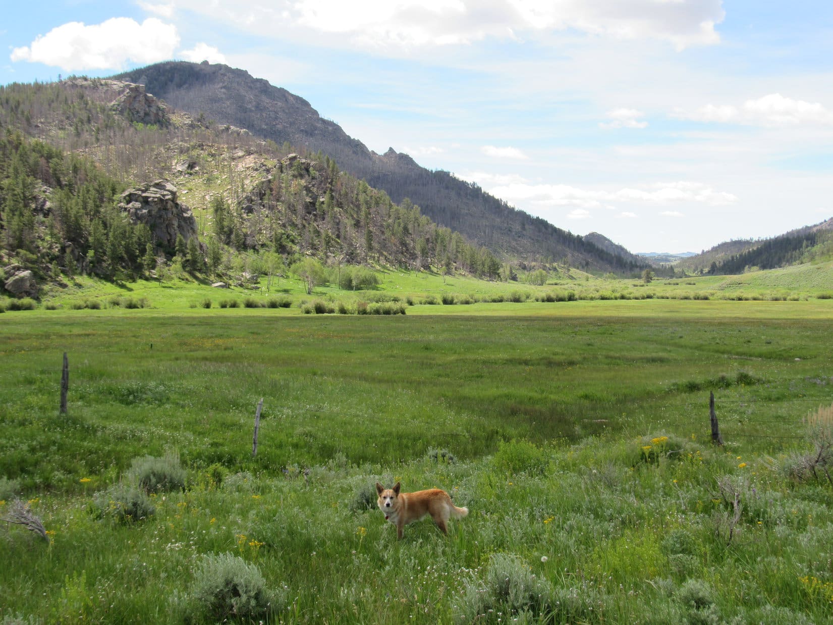
The Carolina Dog ran down to Silver Tip Creek for a drink of cold water, then trotted into the big green field.  Sniffing and exploring happily, she played a little longer in the evening’s glow before heading home (7:03 PM, 65°F).

Looking N toward Jaybird Peak, Laramie Mountains, Wyoming, 6-19-17

Related Links:

                Next Dingo Vacation                          Prior Adventure

This Dingo Vacation                                      Prior Dingo Vacation

Eagle Peak, Laramie Range, Wyoming (6-9-17)

Want more Lupe adventures?  Choose from Lupe’s 2017 Laramie Range, Wyoming & Beyond Adventure IndexDingo Vacations Adventure Index or Master Adventure Index.  Or subscribe free to new Lupe adventures.

Black Hills, SD Expedition No. 216 – Boulder Hill (11-18-17) & Tunnel Ridge (11-19-17)

Lucky Dingo!  Expedition No. 216 was going to have two parts.  Mark and Hillary were in the Black Hills!  Their time was limited, but they could spend a few hours hiking with Lupe and SPHP.  Boulder Hill (5,331 ft.) would be a good destination.  A trail goes all the way to the rocky top, and the summit offers some pretty nice views for moderate effort.

Loop and the gang arrived at the Boulder Hill trailhead of Flume Trail No. 50 before noon.  Everyone hit the trail, heading SE through a Ponderosa pine forest which had been greatly thinned since the last time Lupe and SPHP were here.  Only 0.33 mile from the trailhead, a saddle was reached between Boulder Hill and Storm Hill to the NE.

Beyond the saddle, a spur off Flume Trail No. 50 followed a dirt road S.  The spur soon left the road, leading around the S side of Boulder Hill to the SW.  Although Boulder Hill was only 0.5 mile S of the trailhead where Lupe had started, by the time she had circled around to the SW base of the rocky summit ridge, the Carolina Dog had already gone more than 0.75 mile.

The fun part of the climb was all that was left now!  The trail leading up the ridge wound around among the rocks, passing near numerous viewpoints along the way.

Mark, Hillary & Lupe near the start of the short, but fun climb up the rocky ridge on top of Boulder Hill. Photo looks N.
Lupe at one of the first vantage points. Photo looks NE.
Hillary gazes toward Black Elk Peak (7,231 ft.) (L). Photo looks WSW.
Hillary leading Mark on the way up. The trek to the top only takes 5-10 minutes. Photo looks S.

The trek to the top only took 5 or 10 minutes, plus a little time spent checking out views along the way.  Although this was Lupe’s 6th ascent of Boulder Hill, Mark and Hillary had never been here before.  They both seemed pretty happy with the interesting hike up, and the views available from the summit.

Of course, Lupe and SPHP never tire of seeing the world from a nice high point like Boulder Hill.  Having Mark and Hillary’s company was a big added bonus!

Lupe, Hillary & Mark arrive at Boulder Hill’s summit. This was the first time Mark and Hillary had been here, but Lupe’s 6th ascent. Photo looks NW.
Lupe was glad Mark & Hillary had taken the time to visit Boulder Hill with her. Their company was a rare treat! Photo looks NW.

Boulder Hill has two separate summit areas.  They are practically right next to each other, and of about equal height.  Naturally, Lupe, Mark, Hillary & SPHP visited both.  It was only about 40°F and a chilly breeze was blowing, so the stay on top of the mountain was fairly brief.  Soon everyone started down again.

Mark & Hillary start down. Photo looks NNW.

Lower down, on part of the ridge better protected from the breeze, everyone stopped to relax and have a longer look around.  Mark & Hillary had brought sandwiches.  SPHP had apples and chocolate chip cookies.  Lupe had Taste of the Wild.

Surprisingly, it turned out that Lupe wasn’t the only Carolina Dog conducting tours of Boulder Hill today.  Another Carolina Dog named Legos appeared!  Legos was snappily dressed, and leading a man and a girl up the trail.  In an odd coincidence, it turned out Mark and Hillary had met the man at a store only yesterday.

Lupe wasn’t the only Carolina Dog giving tours of Boulder Hill today! Snappily dressed in orange & gray, Legos appeared during break time. Legos was leading a man and a girl up the mountain.

Legos eventually led his party on up the trail.  Mark and Hillary needed to get going, too.  They had a social engagement this evening, and would return home to Colorado tomorrow.  Except for the return trip to the trailhead, Lupe’s trip to Boulder Hill was over.

Lupe had enjoyed the outing, and SPHP really had fun visiting with Mark and Hillary.   They’d had a good time, too, and felt Boulder Hill had been a great choice for the amount of time they’d had available.

The next morning the lucky Dingo was back in action, again!  Things were back to normal.  Just Loop and SPHP set out on Deerfield Trail No. 40 going up Rapid Creek from Silver City (10:13 AM, 41°F).

Lupe has been on this section of the Deerfield Trail many times.  In fact, she first came here in January, 2012 on both Black Hills, SD Expeditions No. 1 & No. 2.  In a sense, this was where her life of adventures began.  SPHP had a new peakbagging destination in mind for her today, but the first part of the journey along Rapid Creek, was familiar territory.

On Deerfield Trail No. 40 near Silver City. This was familiar territory! Lupe’s first two Black Hills, SD expeditions way back in January, 2012 had been here.
One of several fine footbridges across Rapid Creek upstream of Silver City.
Loop on the bridge. Though there were quite a few footprints in the thin layer of snow, Lupe saw no one on or off the trail all day long.

Lupe had a great time exploring the forests alongside the trail.  She was mainly looking for squirrels to bark at, and found a few, which made her very happy.  Loop checked out the views along Rapid Creek, and visited an old abandoned horizontal mining shaft which she ventures into every time she comes this way.  The shaft is only 20 or 25 feet long, but would make a great Dingo shelter in wet weather.

Going upstream from Silver City, Deerfield Trail No. 40 is never far from Rapid Creek, the largest stream in the entire Black Hills.
Lupe at the entrance to the horizontal mining shaft. This mining shaft is only a few feet off Deerfield Trail No. 40, and makes a great Dingo cave!
Looking out from near the end of the shaft.
Continuing upstream on the trail.
At another bridge over Rapid Creek.

Deerfield Trail No. 40 is a beautiful, easy trek along Rapid Creek.  After she’d gone about 2 miles, though, Lupe was getting close to the Canyon City area where she would leave the trail.

Shortly after crossing yet another bridge, Lupe arrived at this bend in Rapid Creek. She was almost to Canyon City and would soon leave Deerfield Trail No. 40.
This little swampy area comes just before Kelly Gulch close to Canyon City.

No town or much of anything else is at Canyon City these days.  It’s only a spot along the trail, and a point on the map.  About 0.25 mile before she got there, Lupe left Deerfield Trail No. 40 and Rapid Creek behind.  She turned N following a path up Kelly Gulch.

Following the snowy path up Kelly Gulch. Photo looks N.

Kelly Gulch was the start of Lupe’s search for her peakbagging goal for the day, the summit of Tunnel Ridge (5,905 ft.).  Loop wasn’t in Kelly Gulch very long, though.  After only 0.2 mile, she came to a little parking area.  Two roads left this point.  The better road continued on up Kelly Gulch.  Lupe took USFS Road No. 142.1D up Spurgeon Gulch instead.

On USFS Road No. 142.1D going up Spurgeon Gulch. Photo looks NNW.

Lupe had gained very little elevation down along Rapid Creek.  She gained some coming up Kelly Gulch.  Her climb really began in earnest, though, here in Spurgeon Gulch.  The Carolina Dog gained elevation steadily now.  She came to an unmarked intersection where a side road turned W, but she continued straight ahead.  USFS Road No. 142.1D, if that’s what it still was, deteriorated and steepened.

Apparently USFS Road No. 142.1D sees little use these days. As Lupe followed it up Spurgeon Gulch, she came to places where the road was totally blocked by deadfall.

After going 0.75 mile up Spurgeon Gulch, Lupe arrived at a saddle in a small grassy open area where the road reached a “T” intersection.  Some heavily forested hills could be seen from here.  They weren’t far away, and the terrain seemed confusing.  SPHP wasn’t certain which way Lupe should go.

Loop needed to work her way N, but straight N went down into another deep ravine.  Staying on the roads, she had her choice of NE or W.  The American Dingo tried the road going NE first.  This road climbed gradually and seemed promising, but it soon turned R wrapping around a hillside until the position of the sun told SPHP that Loop was going S.

Lupe reaches the saddle at the upper end of Spurgeon Gulch. She had come up from the R. The road she’d been on came to a “T” intersection here. Photo looks NE along the branch Lupe explored first.

Going S wasn’t going to work at all.  Lupe had a decent view of the hills nearby.  It didn’t look like there was any way this road could turn N without losing a bunch of elevation.

The first road Lupe tried from the saddle went NE. It soon curled around a hillside and turned S leading to this view. This was definitely the wrong way. Photo looks SE.

Loop turned around and returned to the saddle.  Time to try the road going W.  Almost immediately, it angled NW and started gaining elevation steadily.  Promising once again, but Lupe hadn’t gotten too far before she reached a bend where this road curved sharply around to the S, too.  Hmm.  What now?

At the bend, the ravine the road had been climbing continued NW.  Lupe could see a stand of large brown-barked Ponderosa pines on a slope below rock outcroppings.  Why not keep going that way?  It seemed like the best option.  Lupe left the road, continuing NW up the ravine.

Lupe among the large brown-barked Ponderosa pines after leaving the road. Photo looks N.

Loop only had to follow the ravine a little way before she appeared to be approaching the upper end of it.  She turned N, scrambling up between the rock formations to reach a small ridge.  On the other side, not very far below her, Loop saw another road heading NW.  That was promising!  Lupe worked her way down to the road and followed it.

Loopster was still gaining elevation, though more slowly than before.  Eventually this new road joined another one heading NNW, exactly the direction Lupe needed to go.

Lupe at the intersection with another road that went NNW. She had come up the road seen on the L. NNW is toward the camera, and just the direction Loop needed to go. Photo looks SSE.

The road leading NNW gained only a little more elevation before topping out.  The terrain ahead was now mostly flat to rolling.  Lupe had succeeded in reaching the top of Tunnel Ridge, but exactly what part of it wasn’t clear yet.

Tunnel Ridge (5,905 ft.) is roughly 3 miles long N/S, and as much as 0.50 to 0.75 mile wide E/W.  It was all forested, so it was hard to see very far ahead.  There didn’t seem to be any definite ridge line to follow.  Loop was probably only 0.33 to 0.50 of the way from the S end.  The true summit was near the N end, which meant it was probably 1.5 to 2 miles N of Lupe’s position.

The road eventually bent NW and started going downhill.  By now, Lupe had seen occasional glimpses of higher ground perhaps a mile or more to the NNW.  Trying not to lose elevation, Lupe left the road traveling N through a level forest, hoping this area would connect somehow with the higher ground she’d seen in the distance.

Somewhere up on Tunnel Ridge, Lupe left the road to head N through this forest looking for the summit. This proved to be a dead end. Photo looks N.

Instead, Loop eventually found that the terrain dropped off rather steeply.  This was a dead end.  She had to return to the road.  This happened once more, a little farther on.  The road went NW downhill again, and Lupe made another foray off the road.  She climbed N toward a high point, but on the other side, the terrain dropped steeply.

From the high point, Lupe went NW down a long slope, rejoining the road again at a gate near a saddle.  At the saddle was a “T” intersection with another road passing E/W over the mountain.  No road continued N from here, but the land sloped up, so Lupe left the road a third time.

Continuing N off road for the 3rd time. Photo looks NNW.

Lupe was only partway up when she saw the high point to the N again.  She was definitely getting closer.

As Lupe continued her climb, the higher ground she had seen a while ago came back into view. She was definitely getting closer! Photo looks N.

By now, SPHP was confident Lupe was closing in on the summit of Tunnel Ridge.  The topo map showed 4 separate areas enclosed within 5,880 foot contours.  The central contour enclosing the most area contained a site elevation of 5,905 feet, which was likely the true summit.  On the way there, Lupe explored the SW 5,880 foot contour, which contained the 2nd largest amount of territory.

The terrain within the SW 5,880 foot contour was pretty flat, but Lupe found a spot with a view toward Black Elk Peak (7,231 ft.).

Lupe at the high point of the 5,880 foot contour SW of the true summit. This was pretty flat territory! Photo looks W.
A glimpse toward Black Elk Peak (R on horizon) from the SW 5,880 foot contour. Photo looks SSE with help from the telephoto lens.

From the SW high point, Lupe headed for the true summit.  As she got close, she reached yet another unmarked road.

Approaching the true summit, Lupe came to this road. Photo looks NNE.

A short trek on this latest road led Lupe gradually up to a flat area which had to be the true summit.  No views, really.  The summit of Tunnel Ridge (5,905 ft.) was just another slightly higher spot in the woods.

Success! Loop at the true summit of Tunnel Ridge. Photo looks E.
About all there was for a view from the top of Tunnel Ridge was this tree-broken glimpse of a distant ridge to the S.

Partly to check out another small area enclosed within a 5,880 ft. contour, and partly just to see what was there, Lupe left the true summit to explore a broad ridge to the SE.  Loop went all the way to the end.  The terrain was all lower than where she’d just been.

At the end of the ridge SE of the summit. Photo looks SE.

There wasn’t anything much different to see on the SE ridge, so Lupe returned to the true summit.  On the way, she posed on a mighty, massive rock outcropping.

Oh, OK, so it wasn’t a mighty, massive rock outcropping – just a minor one. Lupe still looked pretty good on it!

It was only mid-afternoon, but the sun was already low in the sky.  The G6 was 5+ miles away.  Loop needed to get going.  There wasn’t much reason to hang around the summit, anyway.  On the way back, Lupe retraced virtually the exact same route she’d taken to Tunnel Ridge, minus some of the unnecessary forays that led to dead ends in the forest.

Starting back, still close to the summit.
At the saddle where a road goes E/W across the mountain. All the roads Lupe came to on Tunnel Ridge were unmarked. The one leading back to Spurgeon Gulch is seen beyond Looper. Photo looks SW.

Looper’s journey to Tunnel Ridge had been a peakbagging success.  She’d made it up onto the ridge and found the true summit.  Of course, other than the pretty spots down along Rapid Creek, she hadn’t really come to much in the way of views.  Due to the forest, Tunnel Ridge didn’t have much to offer in the way of scenic rewards.

A rare distant view on the return trip. Photo looks SE.

Yet the journey to Tunnel Ridge had been a good day.  The maze of unmarked roads and promising routes that led nowhere had been confusing, but solving the puzzle was a fun challenge.  Lupe and SPHP enjoyed unbroken peace and solitude from start to finish.  And now a previously unknown part of the map was at least partially explored.

Just being on the move, exploring and sharing this cool day outdoors in the pine forest, made Lupe’s journey to Tunnel Ridge another adventure worth remembering (5:14 PM, 35°F).

Back on Deerfield Trail No. 40, heading for home.

Links:

Next Black Hills Expedition                    Prior Black Hills Expedition

Want more Lupe adventures?  Check out her Black Hills, SD & WY Expeditions Adventure Index, Master Adventure Index, or subscribe free to new Lupe adventures!

Independence Rock & Mine Benchmark, the Natrona County High Point, Wyoming (6-18-17)

Day 11 of Lupe’s 2017 Dingo Vacation to the Laramie Range in Wyoming & Beyond!

On the way to Casper, Lupe was going to go right by a famous landmark from the days of the early pioneers – Independence Rock (6,028 ft.) in the Sweetwater River valley.  She had been by it before a time or two, but had never stopped to take a look around.  Today she had the time, and it seemed like just the sort of thing an adventurous American Dingo ought to do!

Lupe drops by Independence Rock State Historic Site in S central Wyoming.

Independence Rock was once an important landmark on the Oregon, California & Mormon Pioneer trails.  Hwy 220 goes right past it now.  Just off the highway, there’s a rest area with bathrooms, water fountains, and shaded picnic tables.  A sidewalk leads to displays detailing the history and importance of this site to the pioneers, and on to Independence Rock itself.  Lupe and SPHP set off on the short stroll.

SPHP stopped to read some of the displays along the sidewalk, but the Carolina Dog had limited patience with that.  She wanted to get there and experience Independence Rock for herself!

Loop on her way to check out Independence Rock.

One of the dangers the early pioneers faced here so long ago was still around.  Near the base of Independence Rock a man was sitting on a bench where the sidewalk divided to make a loop around the rock.  He said he had just seen a 4 foot long rattlesnake slither across the sidewalk only a few minutes ago.  The rattler appeared to be hunting the numerous gray rabbits hopping about all over the place.

That rattlesnake had the right idea!  Lupe was also keenly interested in hunting rabbits!  Sadly, party-pooper SPHP didn’t think racing around in the tall grass among rabbits and rattlesnakes was such a hot idea.  A very disappointed Lupe was forced to stay on the leash.The good news was that it was permissible to climb right up onto Independence Rock!  The best way up was from the NW.  Used to climbing mountains, getting to the top was easy for Lupe.  She was there in practically no time.

Lupe on top of Independence Rock. Thousands of pioneers had stood on this very rock more than 150 years ago. Photo looks ESE down the Sweetwater River valley.

Also known as the Great Register of the Desert, thousands of pioneers had painted or chiseled their names on Independence Rock by various means.  Only the names actually carved into the granite still remain.Lupe saw some names carved in the rock, but as SPHP read them off, it turned out that Loop didn’t personally know any of these pioneers.  The Carolina Dog lost interest.  She wanted to look and sniff around.  A view of a herd of delicious black cows grazing down by the Sweetwater River was especially interesting.

Lupe was more interested in the views from Independence Rock than the pioneer names carved into it. Photo looks SE from the summit. The hills along the ridge in the distance are the Sentinel Rocks.
Looking SW at the Sweetwater River and Hwy 220. The Charlie Brown Range where Lupe had such a good time climbing Ferris Mountain (10,037 ft.) yesterday is on the horizon on the L. Devil’s Gate, another pioneer landmark, is closer by somewhere in the lower hills on the R.
Lupe’s favorite view from Independence Rock was this one of the herd of black cattle grazing down by the Sweetwater River. Their mooing held her attention. If rabbit wasn’t on the menu, maybe steaks could be? Photo looks SSW.

The view to the E was disappointing.  Loop couldn’t see any horses or covered wagons on the way.  Apparently she wasn’t going to be lucky enough to meet any pioneers at Independence Rock this morning.  She’d thought her chances were pretty good, since it was such a beautiful day for pioneering.  Oh, well!  When she’d seen enough of the views, the American Dingo decided she may as well head back down.

More people who were coming up reported that they’d just seen the 4 foot long rattlesnake again down below, still on the prowl for rabbits.  Loop thought that if she were a rabbit, she’d probably hit the trail W like the pioneers.  Independence Rock was a dangerous place!

On the sidewalk on the way back to the rest area, Lupe kept a pretty good eye and keen nose out for the rattlesnake, but she didn’t see it.  SPHP dawdled again looking at displays.SPHP wanted to do one more thing here, which was to walk down to the Sweetwater River.  Lupe thought that might not be such a bad idea, since those black cows were somewhere along the river.

Lupe and SPHP followed an old abandoned road near Hwy 220.  Unfortunately, it ended at some fences before Loop got all the way to the river.  She never did get close to the black cows, but at least SPHP got a photo of Independence Rock and the Sweetwater River from this angle.

Independence Rock (L) from near the Hwy 220 bridge over the Sweetwater River. Photo looks NE.

Time to move on.  Lupe still had a long way to go today.  After a brief stop for supplies in Casper, SPHP drove W on Hwy 20/26.  A R turn at Waltman onto Natrona County Road No. 104 (Buffalo Creek Road) got Lupe headed NNW toward the small community of Arminto.  Arminto was located N of some railroad tracks 8.5 miles from the highway.

On the way to Arminto. The S end of the Bighorn Mountain Range is in view. Photo looks NNW.

Arminto was a pretty quiet place.  The pavement ended a mile N of town.  Buffalo Creek Road continued on, though, now as Natrona County Road No. 105.  Lupe had a good time barking at scattered herds of cattle as the G6 climbed steadily through classic western scenery.

N of the sleepy community of Arminto, Buffalo Creek Road turned to gravel and began climbing through classic western scenery. Photo looks N.
Western scenery along Buffalo Creek Road. Photo looks NNE.

Lupe was on her way to Mine Benchmark (9,121 ft.), the high point of Natrona County.  Once again, SPHP was using a trip report by famed peakbagger Edward Earl for directions.  15 miles N of Arminto was a 4-way intersection.  Mr. Earl’s instructions said to turn L on Bighorn Mountain Road (Natrona County Road No. 109).  No. 109 wound W & N for a few miles, then began to climb more steeply.

How far the G6 might be able to get along Bighorn Mountain Road wasn’t clear.  Edward Earl had a Nissan pickup truck, and had reported slipping on a steep uphill section, then having to stop soon afterward at a very muddy spot.  He’d had to walk half a dozen miles from there, just to get to where he’d originally intended to park.

The road was a bit damp and muddy, but the G6 made it to the top of the steep section just fine.  Lupe had an advantage being here in mid-June.  Edward Earl’s trip report was for an ascent of Mine Benchmark dated 5-26-2009.  With nearly a month extra of warm, sunny weather to dry things out, there was at least some hope the G6 would be able to get farther than the Nissan had.

The next test came soon.  Beyond the steep climb, the road leveled out and reached a small stream 4 or 5 miles from the turn onto Bighorn Mountain Road.  From Mr. Earl’s description, this was likely the muddy point where he’d had to park the Nissan and continue on foot.  The topo map showed this stream as First Waters Creek.

Lupe and SPHP got out of the G6 for a look.  First Waters Creek was only 4 or 5 feet wide and a foot deep, but the bottom appeared rutty.  Hmm.  It ought to be OK.  Lupe stayed outside while SPHP gave it a go.  The G6 hit bottom lightly in one of the ruts, but made it across undamaged.  Lupe waded over and hopped in.  Onward!

Edward Earl mentioned two more streams ahead, still several miles away.  Bighorn Mountain Road resumed a steady climb.  After a few miles, Lupe reached a high point at a 8,300 foot saddle.  So far so good, but soon the South and Middle Forks of Buffalo Creek would have to be crossed.  This saddle wouldn’t be a bad place to park the G6, though, if it became necessary.

At the 8,300 foot saddle. Bighorn Mountain Road is in view. Photo looks NW.

Only 0.25 mile N of the 8,300 foot saddle, Lupe arrived at the South Fork of Buffalo Creek.  Once again, Loop and SPHP exited the G6 to assess the situation.  The creek crossed the road in two separate little streams.  The streams were stony, but only a few inches deep.  Yeah, the G6 could do this!  SPHP drove slowly across.  It went fine.  Puppy, ho!

Loop by the sign for the South Fork of Buffalo Creek. The G6 has already made it across. Photo looks WNW.

Another 2 miles.  The G6 confronted the last stream, the Middle Fork of Buffalo Creek.  The Middle Fork was wider and deeper than the South Fork, but still only 6 inches deep.  Stones were the only worry.  Slowly, carefully, the G6 inched across and triumphed again.  Hah!

The Middle Fork of Buffalo Creek. High point 8751 in is view ahead. Photo looks NE.

Lupe was less than 1.5 miles from the 8,450 foot saddle where Edward Earl had intended to park his Nissan pickup.  With no more streams to cross, the G6 was going to get there.  However, on the way up to the saddle, the road passed by a huge purple slope covered with lupines.  Lupe had to get out of the G6 for this!

Lupe among the lupines W of High Point 8751 (L). Photo looks E.
Ah, they smell divine, especially when you have a super sensitive Dingo nose like mine!

After a romp through the lupines, Lupe returned to the G6.  At the 8,450 foot saddle, SPHP parked along a side road leading E toward High Point 8509.  It wasn’t yet 4 PM, and Mine Benchmark (9,121 ft.) was only a couple miles away now at most.  Plenty of time to get there and back!

Lupe was certainly out W.  Perhaps there was a wicked witch around?  The lupines had the same effect on Loop and SPHP as the poppies had on Dorothy and Toto in the Wizard of Oz.  Instead of setting out promptly for Mine Benchmark, both were soon fast asleep.

Perhaps there was a wicked witch around? American Dingo, Toto, snoozes the afternoon away under the influence of lupines.

More than 2 hours went by before the spell was broken.  After 6 PM!  Loopster had better get going!  The topo map showed a survey benchmark at 8,463 foot elevation on the W side of Bighorn Mountain Road.  The marker ought to be near the start of the side road Lupe was supposed to take to Mine Benchmark.  Leaving the G6, Loop and SPHP set out in search of the 8,463 foot benchmark (6:21 PM).

Sure enough, the American Dingo found the survey marker right about where the map showed it.  Until now, she hadn’t even noticed the road she was supposed to take to Mine Benchmark.  It could be seen from here, though, grassy and faint, heading SW toward a forest.

This 8,463 foot survey benchmark is only a little W of Bighorn Mountain Road.
Lupe stands near the 8,463 ft. survey benchmark, which is seen on bare ground at the lower R. The faint, grassy road Lupe would take in search of Mine Benchmark is in view beyond her heading for the trees. Photo looks SW.

Lupe and SPHP struck out on the faint grassy road for Mine Benchmark.  Once in the forest, SPHP began to worry about the possibility that the road would deteriorate beyond recognition.  It seemed abandoned.  Deadfall timber blocked it in places.  Lupe reached a locked gate in a barbed wire fence, but went under it.

Half an hour after Loop left the 8,463 foot survey benchmark, she emerged again from the forest.  Suddenly she was out on open ground where it was possible to see.  There wasn’t much left of the road most places, but it hardly mattered now.  Lupe could see a big hill to the W.  That had to be it!  Getting to the Mine Benchmark was going to be easy!

This was just the type of high, open territory Lupe loves.  The lupines had lost their effect.  The Carolina Dog was energized now!  She raced away to explore this beautiful place.

After emerging from the forest, Lupe took off running! She loves this kind of high open territory. Mine Benchmark is up the slope on the R. Photo looks WSW.
An elk was surprised to see Loop and SPHP.
Lupe on a better portion of the road again. This road would take her W and pass only a short distance S of Mine Benchmark. The route was all out in the open from here, and the views were beautiful! High Point 9,109 (Center) is in view. Photo looks SW.

Lupe soon reached a slope immediately S of Mine Benchmark.  Large boulders were scattered here and there.  It wasn’t far to the top.  A little bird, probably the same one that tells all sorts of news and rumors, watched Lupe with curiosity as the Carolina Dog began the final part of her ascent.  The easiest way up was from the SE.

This little bird watched Loop with curiosity. No doubt it intended to spread the news of Lupe’s success as soon as she reached the top of the mountain.
Loop on one of the scattered boulders on Mine Benchmark’s SE slope. The summit isn’t far away. It’s right up there on top of the rock formation on the R. Photo looks W.

The scramble to the top took only a few minutes.  The summit area was roomy and fairly flat.  The highest, rockiest parts were toward the SW end.  Big rocks along the S and W edges of the summit area sat above cliffs of modest height.  Many of the big rocks were separated by sizable gaps that had eroded out between them.

Loop got out on the big rocks for a look around.  Panoramic views of beautiful, rolling Bighorn Mountain meadows spread out before her!  It was the kind of territory that made you want to wander forever.

Loop on one of the big rocks along the SW edge of Mine Benchmark’s summit area. A typical big gap between the large rocks here is seen on the L. Gorgeous rolling meadows of the S Bighorn Mountains are in view. Photo looks WSW.
Lupe among the rocks near the W end of Mine Benchmark’s summit area. Photo looks NW.
High Point 9109 is on the far ridge beyond Lupe. Photo looks SSW.
Lupe along the S edge of the summit area. Photo looks SSW with help from the telephoto lens.
Looking WSW.

Pieces of an old wooden structure were laying around the summit area, and some smooth wire was draped among the rocks.  These were reminiscent of what Lupe had found up on Squaw Mountain (9,313 ft.), the Shirley Mountains High Point (9,151 ft.), and Quealey Benchmark (9,150 ft.) earlier on this Dingo vacation.  Lupe also found the actual Mine survey benchmark nearby.

The actual Mine survey benchmark.

Although a couple of big rocks looked almost equally high, SPHP thought a large slanty one toward the N was clearly the highest.  Lupe needed a boost to get up on top, which SPHP was glad to give her.

After a boost from SPHP, Loop stands on top of the large slanty rock that appeared to be the true summit of Mine Benchmark. Photo looks N.
Still on the true summit. The forested top of High Point 9065 is in view just above the highest part of the slanty rock Lupe is on. Photo looks N.

The Carolina Dog let SPHP help her get down from the true summit, though she had appeared imminently ready to leap off all on her own.  Once down, Lupe did some more exploring of the summit area.

More of the Mine Benchmark summit area is seen here. Part of the old wooden structure is in view. (It wasn’t anything very large.) In the distance, High Point 8509 is in sunlight a little to the L of Lupe. The G6, where Lupe had started here from, was parked in the meadow below it. Photo looks NE.
Lupe also discovered this white tube tucked between big rocks. SPHP didn’t mention it in notes, and no longer remembers what it contained. Maybe a registry was in there? Maybe the contents were soaking wet? If you go to Mine Benchmark yourself, take a look inside and let Lupe know if her name is on a registry inside or not! Photo looks N.
The summit area curved from the W around to the NE. The W part was highest. The NE part somewhat lower, but also scenic. Here Loop is in between the W and NE ends. Photo looks NNE.
Loop a little farther NE along the summit ridge. A chilly breeze was blowing out of the NW. High Point 6509 is seen on the R. Photo looks NW.

A chilly NW breeze kicked up while Lupe was exploring some of the NE part of the summit ridge.  Loop and SPHP left the ridge to get out of the wind.  Loop circled back around to the SW side of the Mine Benchmark summit formation.

After leaving the Mine Benchmark summit ridge to get out of the wind, Loop circled around to the SW. Photo looks NNE back up toward the highest part of the Mine Benchmark summit formation.

It was a gorgeous evening.  The sinking sun would be down within the hour.  Although Lupe had successfully completed her Mine Benchmark peakbagging objective, maybe sunset was worth sticking around for?

Lupe and SPHP hung around S of the high point for 20 minutes to see what might develop.  Loop was greatly entertained watching several nervous pronghorn antelope.

While waiting to see if a colorful sunset might develop, Lupe was entertained watching a few nervous pronghorn antelope.

The chilly NW breeze was still blowing when Lupe returned to the Mine Benchmark summit.  The sun would be down pretty soon now.  Quite a few clouds were off to the W.  Hope existed for a brilliant display, but maybe the sun would just disappear behind the clouds.

The sun was sinking fast when Lupe returned to the Mine Benchmark summit. Hopes existed for a brilliant display.
Loop back up on Mine Benchmark resting and waiting eagerly for news from SPHP on how the sunset was progressing.

Day’s end was beautiful, but the eagerly anticipated spectacular display never developed.  Though Lupe waited hopefully, clouds ultimately swallowed the sun.  It was gone.  The sky darkened.  Everything began fading to gray.  Night was coming.  Time to go.

Two stars, or perhaps planets, twinkled above by the time Lupe made it back to the G6.  She had dinner, then rested outside on the ground watching, listening, and sniffing the air.  Meanwhile, two lonely stars were joined by 2,000 more in the black void above.

Awaiting sunset on Mine Benchmark, the Natrona County high point, Bighorn Range, Wyoming 6-18-17.

Links:

Next Adventure                      Prior Adventure

Edward Earl’s 5-26-2009 ascent trip report for Mine Benchmark

Want more Lupe adventures?  Choose from Lupe’s 2017 Laramie Range, Wyoming & Beyond Adventure IndexDingo Vacations Adventure Index or Master Adventure Index.  Or subscribe free to new Lupe adventures.