
Day 1 of Lupe’s 2017 Dingo Vacation to the Laramie Range, Wyoming & Beyond
Nine months gone. Practically an eternity! Late in the evening, Lupe laid sad-faced and bored on the even sadder-looking old couch clawed up by 4 cats who no longer lived here. Did she ever even think anymore about those glorious days of her last and greatest 2016 Dingo Vacation when she’d gone all the way to the Canadian Rockies, Yukon & Alaska?
If so, you couldn’t tell it. Of course, maybe she was thinking of those times, and how long ago and far away it all seemed was what was making her sad. Loopster heaved a sigh, staring vacantly over the edge of the couch. She looked like she had lost her last friend.

She hadn’t, of course. She’d been on lots of Black Hills expeditions full of adventures with SPHP over the last nine months. Fun times, but not the same as hitting the open road for days on end spent exploring exciting, beautiful, distant lands.
While Loop moped on the couch, SPHP was not idle. A warm, fragrant breeze stirred the air. Late spring by the calendar. Early summer by SPHP’s reckoning.
Better enjoy lounging around like that while you still can!
Lupe’s eyes shifted to watch SPHP busily checking equipment and supplies. Her expression didn’t change.
You’ll see, soon enough!
Promises, promises. Nothing fun happened. Dullsville.
The next morning SPHP was up early. Shower, breakfast, and then back and forth packing all this stuff into the G6. Lupe began to realize something really was up. A glimmer of hope in her eyes grew rapidly to increasing anticipation.
Mountain climbing season, Loopster! It’s here! You ready?
Was she ever! Only a few hours later, Lupe was in Wyoming, whizzing along in the G6 headed for her first adventure of her first Dingo Vacation of 2017. Had the mood ever changed from last night! Looper was ready to let the good times roll!

Lupe was headed for the Laramie Mountains in SE Wyoming. Only 8 days into June, it was still weeks early to head up into some of the higher Wyoming ranges for mountain climbing, since there would still be too much snow on the peaks. However, with the exception of Laramie Peak (10,272 ft.), the highest mountains of the Laramie Range top out only a little over 9,000 ft. There might still be some snow around in early June, but not enough to be a problem.
By early afternoon, Lupe reached Douglas, Wyoming. SPHP drove S from there on Hwy 94. The highway eventually turned to gravel and became County Road No. 5. A mile N of Esterbrook, SPHP had planned to let Lupe tag Prairie Dog Hill (6,400 ft.) as her first peak “climbed” in the Laramie Range this year. It wasn’t even really a climb at all, since County Road No. 5 goes almost right over the high point. Pathetically easy.
However, when Lupe arrived at Prairie Dog Hill, a cattle drive was in progress right on the road. Lupe was almost out of her mind with delight! She bounded from window to window of the G6 in a foaming-at-the-mouth barking frenzy. She was eager to get out and help drive some cattle herself! Not such a good idea. The cowboys might have an issue with that. SPHP drove on, turning E at Esterbrook on USFS Road No. 633.
No. 633 wound N & E for several miles. Shortly after passing Esterbrook Campground, the road began to lose elevation and turned S. Lupe’s first real peakbagging objective, Black Mountain (7,960 ft.), came into view.


Black Mountain was still 9 or 10 miles SSW from where it first came into view. On the way there, Lupe stopped by Horseshoe Creek, which flowed right along USFS Road No. 633 for a couple of miles.

Looking for USFS Road No. 667, SPHP turned off No. 633 at Camp Laramie Peak, a Boy Scout camp at Harris Park. Lupe and SPHP made inquiry at the main office on how to find No. 667 to Black Mountain.

Camp Laramie Peak was just opening up for the summer season. Councilors were already here, but the first Boy Scouts were just beginning to arrive. Fortunately, an official was available who told SPHP that USFS Road No. 667 (unmarked) to Laramie Peak went right through the camp. He pointed out a road that went S down a little hill.
The road would quickly deteriorate to a high-clearance proposition – it wasn’t going to be G6 friendly at all. This was known in advance from the topo map where No. 667 was marked 4WD. The intention all along had been to ditch the G6 somewhere, and follow the road on paw and foot. Fortunately, SPHP was free to park the G6 at Camp Laramie Peak at a small parking area near the main office.

At 3:08 PM (79°F), Lupe and SPHP set off. There had been one caveat mentioned at the office about taking USFS Road No. 667. The road went through Boy Scout property for the first half mile or so. Leaving the road was not permitted. No trespassing on Boy Scout land! Seemed like an odd demand from an organization dedicated in part to promoting the outdoors, but another official reiterated this rule as Lupe and SPHP ambled along the road through the camp.
Whatever, no problem. SPHP adhered rigidly to this restriction. The American Dingo, having spent most of the day cooped up in the G6, was somewhat less diligent. Lupe had a fun time roaming and exploring the forest not too far from the road.
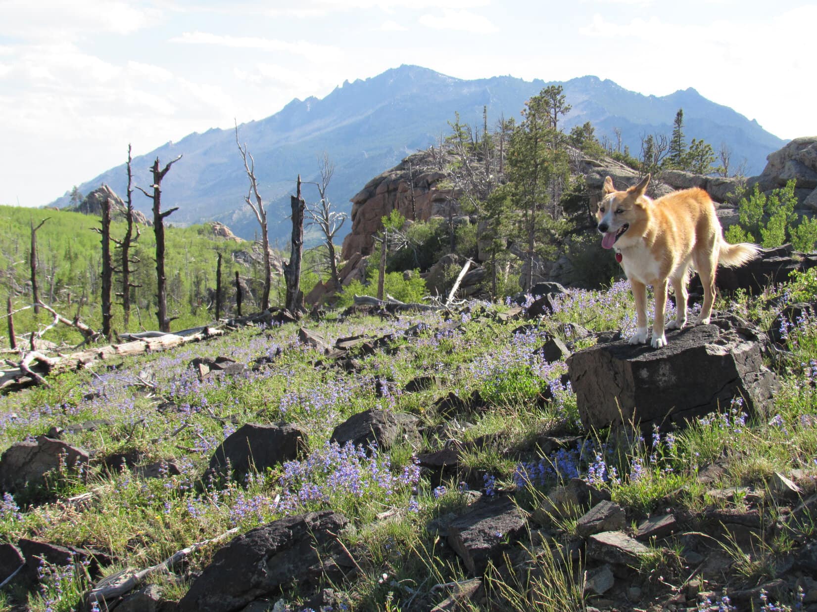
After dipping down through camp, No. 667 crossed a small stream and then began to wind W climbing steadily. Bluebells were growing in profusion in the forests and fields. It was a pretty day, a bit warm, and Lupe was off to a good start. She was beyond forbidden Boy Scout territory in a jiffy. A mile from camp, she arrived at a minor saddle near large rock formations.


Still hidden from view more than a mile N of the minor saddle was Peak 7320, another mountain SPHP hoped Lupe would get a chance to climb. First things first, though! The road turned due S from the saddle and climbed more steeply than before. Lupe followed it, continuing toward Black Mountain.
No. 667 soon turned SW and leveled out for a little way. Peak 7320 now came into view back to the N. The mountain was capped by a huge knob of solid rock. Lupe might not be able to get to the top, even if there was time enough later on for an attempt.

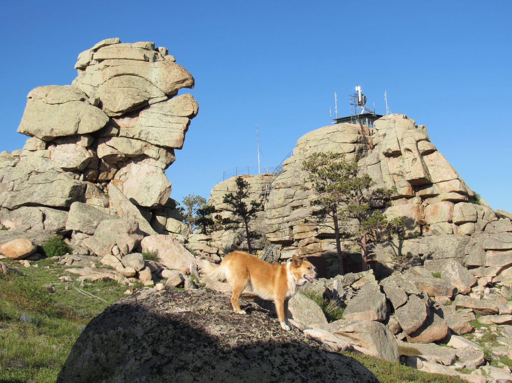
Off to the SW, the summit of Black Mountain had come into view, too. It was a little hard to recognize at first, but got easier to discern as Lupe continued along the road. A fire lookout tower was perched way up on the highest rocks.


No. 667 soon began to climb again fairly steeply. Before long, it made one big jog to the NW before turning sharply S. Once it made the turn, the road started leveling out. Lupe was still gaining elevation, but at an easy pace. The Carolina Dog now enjoyed a pleasant journey S to the summit along the big N ridge.
The views were increasingly beautiful! Albany Peak (7720 ft.) could be seen to the SSE. A little farther on, Laramie Peak (10,272 ft.) came into view to the SW.


Lupe continued S along No. 667 until it curled around a big rock formation, and suddenly ended at the base of the massive stone knob the fire lookout station was perched on. A steep metal stairway was the only way up.

The American Dingo didn’t like the look of those stairs! She stayed at the bottom, while SPHP climbed the first longest section. SPHP had to plead with her to follow. She finally did come up, but not until SPHP was about ready to go down and get her.
A metal platform turned 90°, and led in a few feet to a 2nd shorter flight of stairs. SPHP climbed this 2nd set, only to turn around and see Lupe running back down the 1st flight all the way to the bottom again. SPHP returned to the top of the 1st flight to resume pleading and coaxing. Looper finally relented. This time she made it all the way to the fire lookout station to claim her peakbagging success!

The day had been warm and the air calm all the way up the mountain. Even down at the base of the metal stairway, there hadn’t been much of a breeze. However, up at the fire lookout tower, it was considerably cooler. An annoyingly strong gusty wind was blowing out of the SSE. The last bit of elevation gain had made a surprising difference!
It was so windy, Loopster wanted to take shelter in the lookout tower. She was most disappointed that it was padlocked shut, and no one was around to let her in. The views were splendid in every direction. Somewhat reluctantly, the Carolina Dog cooperated with taking photos. She preferred to spend her time on the N side of the tower out of the wind.
Lupe and SPHP made several forays around the tower to check out the views, returning frequently to the N side for breaks from the wind.


Lupe spent a good 30 minutes up at the summit of Black Mountain (7,960 ft.). Before leaving, the Carolina Dog and SPHP took a longer break out of the wind on the N side of the lookout tower. Lupe had water and Taste of the Wild. Then it was time for one last look at Laramie Peak from the top, and a final stroll around the lookout tower.


In her eagerness to get out of the wind, Lupe showed no fear of the long metal stairway leading down to USFS Road No. 667. She raced to the bottom in nothing flat. It was still a little breezy back down at the road, but nothing compared to the gusty wind up at the tower.
SW of the lookout tower were some great viewpoints where Laramie Peak was on display. Lupe took a little time to sniff around and explore this area.

When Lupe was satisfied with her explorations of the summit area, she headed back N along USFS Road No. 667. She would retrace her route up following the road all the way back to Camp Laramie Peak.

Although SPHP had hoped Lupe would have time to take a crack at Peak 7320 on the way down, the sun was starting to get low. Since it looked like there wouldn’t be sufficient daylight to summit and get back to the road before dark, Lupe never made the attempt.

It was 9:11 PM (52 °F) when Lupe reached Camp Laramie Peak again. In fading light, she was treated to a ride S in the G6 down the Cottonwood Creek valley on County Road No. 71. SPHP wanted to check out potential access routes to Albany Peak. Maybe Lupe could climb it tomorrow?
There proved to be numerous homes on private property along County Road No. 71. “No Trespassing” signs were posted all over the place. SPHP found one possible access point, but it wasn’t clear if this route went across private property or not. From Black Mountain, Lupe had seen a very large rock formation at the top of Albany Peak. Maybe she couldn’t even get to the top of the mountain, even if there was access?
Reluctantly, SPHP decided Lupe should skip Albany Peak, at least on this trip. SPHP drove N again, as Lupe barked enthusiastically at antelope grazing in the fields at dusk. It was dark by the time Lupe stopped at a pullout along USFS Road No. 633 near Horseshoe Creek for the night.

Only 24 hours ago, Lupe had been bored and despondent on the tattered old couch back home. Yet today she’d had a blast traveling to Wyoming and climbing Black Mountain. The lucky American Dingo’s summer of 2017 adventures had only just begun!

Links:
Next Adventure Prior Dingo Vacation
Laramie Peak, Wyoming (8-9-15)
2016 Laramie Mountains, Wyoming Adventure Index
Want more Lupe adventures? Choose from Lupe’s 2017 Laramie Range, Wyoming & Beyond Adventure Index, Dingo Vacations Adventure Index or Master Adventure Index. Or subscribe free to new Lupe adventures.
Absolutely fantastic views. I need to visit up there and take some great photos like those.
Luna is now on Black Mountain Lookout. She is also a Red Heeler or Australian Cow Dog. I am the lookout. Cool you visited just before i came up to work. Liked your story.
Roger,
My wife and I manned Black Mtn in 1983. Lately we’ve been reading over our journals from that summer. I am pleased to hear that the lookout is still in operation. Have you seen big horn sheep? bears? My e-mail is philwyoming@yahoo.com. We’d love to hear from you.
I read this wonderful account over again on this 20 degree morning. The Black Mtn landscape looks barren from fires compared to when we were there in 1983. That big microwave? or cell tower was not there in 1983. I’ll have to dig out my slides and compare. Those flowers are penstemon (five stamens), I think.
Do you live in Rapid? One of my high school classmates was a professor at the mining college. We were in frequent e-mail contact until his death recently.
Hi, Phil, and welcome back! Glad to hear that you liked my Black Mountain post enough to return and read it again. Those steep stairs to the lookout station made me nervous, but the mountain itself was wonderful!
You are undoubtedly right about the flowers being penstemon, not bluebells. If the flower is blue, SPHP almost always thinks its a bluebell.
SPHP’s degree is from South Dakota School of Mines & Technology in Rapid. Not a degree in botany, though, as you can tell!
Sorry to learn of your high school friend’s death. Condolences!