
Start – 10:28 AM, 46°F, at the first pullout along West Deerfield Road near Castle Creek W of the intersection with Deerfield Road (County Road No. 306)
Fall colors were over and done with. Sad, but the glories of autumn fade quickly. Nothing new about that. Lupe was still enthused! This bright, comfortably cool day in late October was made to order for a continuation of the Carolina Dog’s recent tour of some of the highest peaks of the Black Hills along the E edge of the western limestone plateau.
Today, Lupe would visit 4 such peaks. She’d been to all of them before more than once, but it had been well over two years since her most recent visit and would be fun to see them again. Besides, SPHP had promised Loop she would get to explore a whole new canyon on the way back at the end of the day.
Something old, something new, that’s what we’re gonna do!
If that’s supposed to be poetry, SPHP, don’t quit the day job.
Hah, too late, I already have!
My, what a big deficit you’re running, SPHP!
Never mind that, the better to go adventuring with you, my dear Dingo!
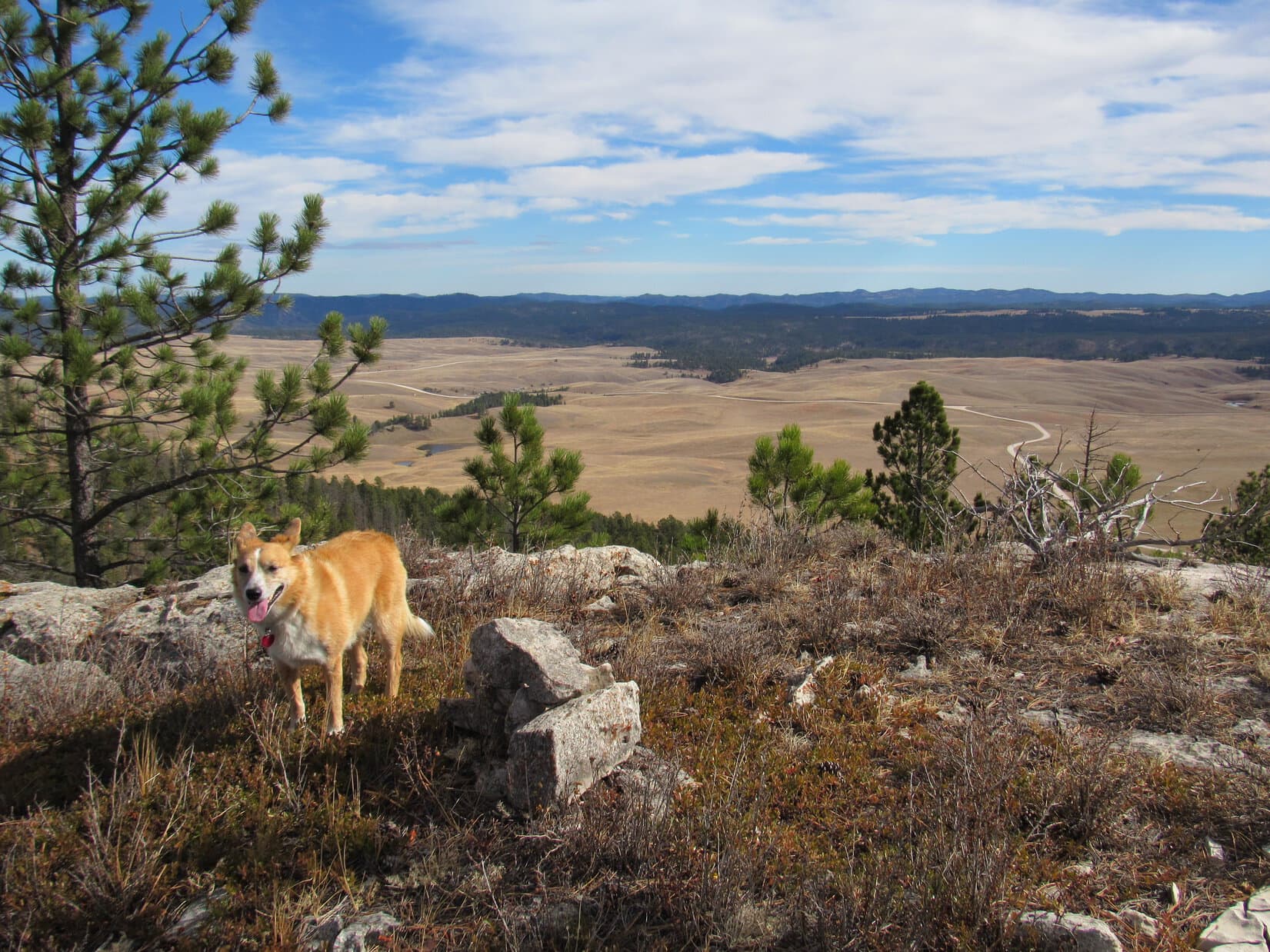
Loopster was totally in favor of that. She started off with a quick look at pretty Castle Creek, which somehow always has good flow even during seasonally dry periods like this. Then the American Dingo crossed West Deerfield Road and began the climb toward her first peakbagging objective, South Castle Rock (6,840 ft.).


A short climb through a pine forest brought Loop to a grassy field. The upper S face of South Castle Rock was already in view. This was going to be a nice, easy stroll most of the way. Lupe headed N through the field, passed through another forested stretch, and was soon back out in the open again. The only short steepish part of the whole climb was up in the trees directly ahead.


The best views from South Castle Rock aren’t from the summit, but from limestone cliffs high up on the far S ridge. That was right on Lupe’s way to the summit, so she went there first. She had a great panoramic view to the S and E from here. To the N, Loop could see the end of nearby Castle Rock’s E ridge.


South Castle Rock has two high points. Being slightly higher, the N high point is the actual summit. From the cliffs along the S ridge, Lupe circled well W of the S high point before turning N again.
The summit wasn’t far off, but the discouraging sight of all the deadfall timber Lupe had to traverse to get to there made SPHP realize the Komperdell trekking poles generously gifted by Jobe Wymore had been forgotten in the G6. Doh! SPHP had used them for the first time a week ago on Expedition No. 211. The poles had been quite useful for nagivating deadfall then, and would have been handy to have here. Oh, well!

The true summit of South Castle Rock (6,840 ft.) sits at the N end of a fairly large limestone cap surrounded by low cliffs. Getting through the deadfall to reach the cap was the hard part. That done, Lupe circled to the SW where the cliffs were lowest. One mighty, unassisted, clawing leap, and she was on top!
At the highest point at the N end, someone had built a cairn since Lupe was last here. Trees hid the views in most directions, but Loop did have a tremendous view of Reynolds Prairie to the E. She also had a clear view of Castle Rock’s E ridge to the NE.


After a short break near the cairn, Lupe left South Castle Rock’s limestone cap at the same SW point where she’d leapt up. Less than a 0.25 mile trek brought her to Castle Rock’s E ridge.
The E ridge was 200 feet wide and rounded, sloping down toward cliffs on both sides. The top was nearly level along most of its length. Lupe followed the ridge ESE all the way to where the ground started dropping toward the cliffs at the far end. The true summit seemed to be here near the ESE end, but it was hard to tell for certain. Having traveled the whole length of the ridge, Loop must have been at the actual high point somewhere along the way.
The apparent summit of Castle Rock (6,783 ft.) was forested and clogged with deadfall, but Lupe had great views from the cliffs along the edges of the ridge in every direction except back to the W.


After visiting Castle Rock’s summit on the E ridge, Lupe headed back W. Although the mountain’s long, skinny N ridge is somewhat lower, she went out onto it. A big, flat, barren area at the southern end of the N ridge provides good views to the W and NE. This area is Lupe and SPHP’s favorite part of Castle Mountain. Despite the openness, the whole place has a secluded, tucked-away feel.


The easy way off Castle Rock’s N ridge is found on the E side almost at the S end. Lupe followed an animal trail down there. She lost elevation traveling N well below Castle Rock’s N ridge where the slope wasn’t too bad. This was a forested area full of long grass hiding an annoying amount of deadfall timber. SPHP was soon wishing for those Komperdell trekking poles again.
Nipple Butte (6,810 ft.), Lupe’s next destination, was 0.5 mile away. The deadfall didn’t let up until she reached the saddle leading to Nipple Butte from Castle Rock. Once she traversed the saddle, the climb steepened quickly. Lupe was approaching from the S, but the best way up is a chute on the WNW side of the mountain, so she circled around to the W as she went higher.
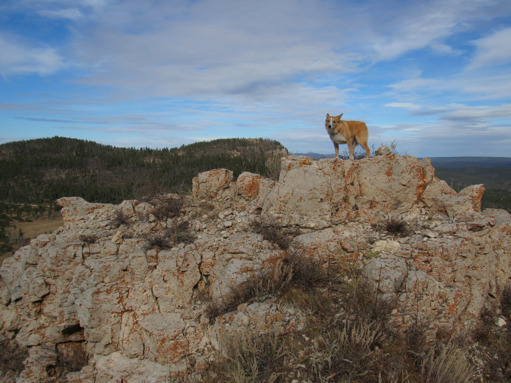
The top of Nipple Butte is a ragged, rugged chunk of limestone with lots of broken rock below on most of the surrounding slopes. Of all the peaks Lupe was visiting on Expedition No. 212, Nipple Butte was the only one that was at all scrambly. The Carolina Dog got a bit too high, too soon, reaching the rocky slopes while she was still SW of the summit.

It would have been faster, if Loop and SPHP had circled around farther to the W before getting so high, but it didn’t really matter. Lupe crossed a slope of broken limestone scree, and reached the chute on the WNW side of the mountain.

The chute was steep, but not long. Lupe was at the top in no time. Before going to Nipple Butte’s true summit, she got up on the high point N of the upper end of the chute.
From the top of the chute, a six foot high wall of limestone was all Lupe had to get up to reach the summit. The six feet were simply too high and vertical for her to manage on her own. However, there were a couple of rocks SPHP could stand on from which she could be boosted to the top.
Meekly, the American Dingo lifted one of her front paws. She needed help and was ready for assistance. SPHP picked her up, stepped into position, and lifted her to the small limestone platform at the top of Nipple Butte. SPHP then scrambled up after her.
A single chunk of limestone 1.5 feet higher than the rest of the summit platform is the true summit. It was large enough for Lupe to stand on. So easy, yet dramatic. She’d made it! There Lupe stood, on the tiny absolute top of Nipple Butte (6,810 ft.) with 360° views!
Oh, yeah! Nice work, Loop. Photo time!


Lupe and SPHP sat together up on Nipple Butte for a little while. The sense of space and airiness from the tiny platform is among the best on offer anywhere in the Black Hills.
When the time came to go, SPHP climbed down first. The American Dingo remained on top for one last photo atop the summit rock.


One more peak to go! SPHP helped Loopster off the summit platform. Puppy, ho! Back down the steep WNW chute to broken limestone scree leading to scattered boulders, and finishing it all off with the usual deadfall infested trek in the forest.

Lupe reached USFS Road No. 189 at the saddle leading to Flag Mountain. Half a mile NW of here a spur road leaves No. 189. The spur winds 0.75 mile NE almost to the top of Flag Mountain.
Nah, not that way! Instead, Loop crossed No. 189 heading N. Traveling directly up Flag Mountain’s S ridge would be shorter and more fun. An hour after leaving Nipple Butte, the Carolina Dog was standing in the remnant of the old fire lookout tower on Flag Mountain (6,937 ft.).


Flag Mountain was the highest of any of the peaks Lupe climbed today. The views were grand, though this much larger summit area did not give quite the same feeling of exposure and airiness she’d had up on Nipple Butte.
Early in the day, there had only been a light NW breeze. By the time Lupe reached Nipple Butte, the wind had switched to the SW and picked up to about 15 mph. The same SW wind was still blowing up here. With the sun now noticeably progressing toward the horizon, the breeze felt a bit chilly.
Lupe and SPHP lingered up on Flag Mountain anyway. This was warm compared to what would likely be coming before too long. Who knew how many more weeks it would be before cold and snow would take over up in this western high country?


With 4 successful ascents, Lupe had completed all of her peakbagging objectives for Expedition No. 212. The time had come for SPHP to honor the promise to let her roam some never before explored territory in the big canyon W of South Castle Rock, Castle Rock and Nipple Butte.

Lupe left Flag Mountain traveling W. She ultimately took a route down similar to her path up, following the S ridge much of the way. An early turn to the SW served as shortcut to USFS Road No. 189.
Once across No. 189, the American Dingo began her explorations of the big canyon traveling SSW. It was downhill from here all the way to West Deerfield Road.

Lupe saw lots of deer. She got muddy paws and drank from a small stream, a tiny tributary of Horsethief Creek, itself no great torrent. Looper was one busy Carolina Dog the whole way, free to run and play.


The sun was close to setting by the time Lupe neared West Deerfield Road. The G6 was a only short walk SE along the road. Expedition No. 212’s adventures were almost complete. Behind Loop, the top of South Castle Peak still glowed in the last light of day.

That glow was gone before Lupe even got to the G6 (6:01 PM, 36°F). Expedition No. 212 might be officially over, but Lupe’s fun wasn’t. She was back early enough so twilight would last a long time.
For nearly an hour on the ride home, a frantic American Dingo watched for deer, cows and horses to bark at. Many decibels provided near constant earsplitting proof of the success of this project. No doubt a hugely satisfying encore to a splendid day!

Links:
Next Black Hills Expedition Prior Black Hills Expedition
Want more Lupe adventures? Check out her Black Hills, SD & WY Expeditions Adventure Index, Master Adventure Index, or subscribe free to new Lupe adventures!