
Day 10 of Lupe’s 2017 Dingo Vacation to the Laramie Range & Beyond!
As you drive along I-80 through Rawlins WY, you can see in the distance about 35 miles north a mountain range with a very striking feature: a zigzagging white cliff band running nearly the entire length of the range from left to right. That band is the Madison formation, an upended layer of limestone which has subsequently been eroded into a series of V-notches by a succession of streams coming down from the crest above. I first noticed this mountain range in the late 1980s, and that zigzagging line reminded me of the zigzagging line across the bottom of the shirt that Charlie Brown wears. For this reason, I personally dubbed the range the “Charlie Brown Mountains”. – excerpt from Edward Earl’s trip report on his 9-5-2014 ascent of Ferris Mountain on Peakbagger.com
Rain! Not good. If it rained too hard, the dirt road would turn to mud. The G6 might get stuck way out here NW of Bairoil. Better get back to pavement, now!
It was still dark out, but Lupe was already awake. SPHP had just come to. In pre-dawn rain and fog, SPHP drove back to Bairoil. The rain had already let up to a light sprinkle, by the time Lupe reached the pavement on Hwy 73. May as well keep going.
Eight miles E of Muddy Gap, SPHP turned S off Hwy 220 onto Carbon County Road No. 499. The rain and fog were gone, but dark clouds still hid the Charlie Brown Range. It was light out now, but still very early. Lupe was ready for action! SPHP wasn’t.
Gimme a few more hours snoozing time, Loop. Need to wait a bit to see what the weather’s going to do anyway. And with that, SPHP parked the G6 and went back to sleep.
A few hours later, SPHP was ready. Time for Lupe to take on dreaded Ferris Mountain (10,037 ft.), high point of the entire Charlie Brown Range! Of course, that was provided she could even get close enough to make an attempt feasible.
The first part of the way ought to be easy enough. Lupe could follow directions in peakbagging hero Edward Earl’s trip report. She was already at the first place Mr. Earl mentioned, the sign for Pete Creek Road & Cherry Creek Road at the turn off Hwy 220.

Mr. Earl’s trip report contained detailed instructions on how to get to Ferris Mountain. The next thing to look for was 0.9 mile from Hwy 220 along Carbon County Road No. 499, where a road branching off to the R was marked only by an unreadable sign. This intersection quickly came into view.

Mr. Earl’s instructions said to go straight at this first intersection, avoiding the R turn on the unmarked road. 2 miles from Hwy 220 was another R turn, this time onto Cherry Creek Road, which was also to be avoided. Lupe and SPHP stayed on Carbon County Road No. 499 both times, and came to the Handcart Ranch sign 2.5 miles from Hwy 220.


Edward Earl mentioned a fork in the road 4.3 miles from Hwy 220. The R branch goes to a ranch, while Carbon County Road No. 499 continues to the L. Lupe arrived at this fork just as Mr. Earl said.

Edward Earl also said that the condition of Carbon County Road No. 499 worsened beyond this intersection. He cited frequent mud holes which were dry when he was here, but correctly surmised they were mud puddles during wet weather.
SPHP had scarcely made the L turn at the fork, when there was trouble ahead. A large mud puddle fed by a small stream completely blocked the road. Lupe and SPHP got out for a look.

Nope! Not gonna try it! This mud puddle was as far as the G6 was going. Mr. Earl’s trip report indicated that it wouldn’t be much farther before high clearance would be needed anyway. Even though the base of the Charlie Brown Range where Mr. Earl had parked his Nissan pickup truck was still 6.5 miles away, it was going to be paw and foot for Lupe and SPHP from here. Loopster was in for a very long day!
SPHP parked the G6 in the field next to Carbon County Road No. 499, and proceeded to get ready for Lupe’s long march. The ranch headquarters was in sight from this location, not too far away. Soon a vehicle was seen leaving HQ. A couple minutes later, Lupe and SPHP met Kyra Torgensen and her son. The G6 was parked on the ranch Kyra and her husband own. Naturally, she wanted to know what was going on.

SPHP explained that Lupe was here to climb Ferris Mountain. It was only another 0.2 mile to BLM land. SPHP would have parked over there, but the G6 couldn’t get past the mud puddle. Did she mind if the G6 was parked here for the day?
Mrs. Torgensen was a little reluctant at first. However, Carbon County Road No. 499 had to be a public right-of-way, which she must have known. SPHP didn’t mention this fact, though, hoping to avoid an argument. In the end, while she may not have been thrilled with the idea, Kyra Torgensen was fine with the G6 where it was. Before she drove away, she warned SPHP not to stay out too late, and to beware of wolves.
A few minutes later, Lupe and SPHP jumped the little stream, and began the long trek to Ferris Mountain (10:17 AM, 68°F). Only 0.2 mile farther, the Carolina Dog went through a gate onto BLM land. The road forked again. Following Edward Earl’s instructions, Lupe took the road to Pete Creek.

Lupe and SPHP weren’t worried about wolves. However, Ferris Mountain had long been the most dreaded peakbagging goal of this entire Dingo Vacation. The mountain itself wasn’t the worry. Distance wasn’t either. Forewarned by Edward Earl’s trip report, SPHP had realized all along that Lupe would likely have a 6+ mile trek just to get to the Charlie Brown Range.
The problem was the sagebrush prairie Lupe would have to cross. Two of Lupe’s nemeses might well be out there – cactus and rattlesnakes. If Lupe became scared of cacti, she would refuse to move. Rattlesnakes, of course, would be far worse.
For these reasons, SPHP encouraged Lupe to stay very close, preferably right on the road. Most of the time she did.


Fortunately, Lupe saw only a few cactus and no rattlesnakes. Meanwhile, the weather remained questionable. Dark clouds hung around. Sometimes they obscured virtually the entire Charlie Brown Range. Other times, they lifted to reveal the mountains. A significant storm was brewing off to the SE. For a while it came closer, but eventually it sailed off to the NE.
Roughly 4 miles from the G6, Lupe came to a cairn on the L side of Pete Creek Road. Edward Earl mentioned 3 cairns in this area, but the Loop only saw 1.


6.5 miles from the G6, Lupe finally reached the base of the Charlie Brown Range on a grassy ridge E of the mouth of Pete Creek Canyon. A white pickup truck was parked here near the edge of the forest, right about where Edward Earl must have parked his Nissan pickup. Pete Creek Road, which had been going due S for miles, turned SE here.

Lupe still had another 0.5 mile to go on Pete Creek Road along the base of the mountains. On the way, she lost 120 feet of elevation crossing the Rush Creek drainage, where she saw a salt lick noted by Edward Earl. By the time she reached a green metal gate near the mouth of Pole Canyon, she had regained all of the lost elevation and a good deal more.
Beyond the green metal gate, Loop finally left Pete Creek Road. She headed into Pole Canyon, and quickly came upon a different faint road heading up the valley.


Edward Earl had followed this same road up Pole Canyon. His trip report mentioned fallen trees and a few marshy spots, but Mr. Earl had been here in September when conditions are much drier. Pole Creek was no occasional marshy spot in the middle of June, but a clear running stream. It was easy enough to wade across, however, and Lupe enjoyed the cold water.

The road crossed Pole Creek more than once. Lupe also came to marshy glades, where the road hardly existed, but she could usually find it again a little higher up. After a while the road completely disappeared, lost for good.


At 8,450 feet, Loop arrived at the place where Pole Canyon splits. When Edward Earl had been here, only the R (W) branch had flowing water. Both branches had flowing water now. Like Edward Earl, Lupe stayed L (E). As she continued gaining elevation, the creek was increasingly hidden beneath snow.


Lupe stayed to the W (R) of the creek, but it started getting harder to make progress. The forest was dense, and the American Dingo came to more and more rocks and deadfall. The canyon sides steepened, becoming more difficult to traverse. SPHP decided Loop might have an easier time up on the ridge W of the creek.
For a while, leaving the canyon seemed like a good decision. Lupe had no problem reaching the ridgeline. It went straight S rising relentlessly at a pretty good clip, but there was less deadfall to deal with. Sometimes there was even some open ground. When she did come to rock formations, they usually weren’t much trouble to get around. Lupe gained elevation rapidly.


It was a long way up. Lupe gained lots of elevation, but the ridge started getting ever steeper and rockier. Huge rock formations appeared above. Looper ended up on steep slopes of broken rock interspersed with spruce trees. This was challenging terrain. SPHP began to fear there wouldn’t be a way to the top.

The ridgeline had basically disappeared. Lupe now seemed to be going straight up the N face of a mountain. She needed to get to easier terrain. SPHP led her up a very steep rocky chute toward a forested saddle between two massive rock formations.
Loop never made it to the saddle. Everything got so steep, progress ground to a halt. At the top of a long, narrow snow bank, SPHP realized that even if Loop could get up to the saddle, she probably didn’t stand much chance of getting over or around the giant rock formations towering above. She would be trapped between them.

Lupe had to down climb. She needed to get farther E. She didn’t have to lose all that much elevation, but it took a lot of time. Fortunately, it wasn’t terribly far around the huge rock formation above her. Once she managed to get around it, things became easier. The Carolina Dog was still on steep, rocky stuff, but the route up was more manageable.

Loop climbed and climbed. She was very high, and getting close to the top of something! Her luck needed to hold only a little longer. It did. Suddenly she was there! Lupe stood next to a wooden pole at the top of a big cairn. The views were spectacular!

Had Lupe arrived at the top of Ferris Mountain (10,037 ft.)? The grand views, and presence of the big cairn with the pole sticking out of it made SPHP think so.
A more careful look at the views and a glance at the topo map revealed this wasn’t the case. Lupe was already nearly as high as the true summit, but she was actually on Ferris Mountain’s most westerly sub-peak over 10,000 feet. The true summit was in view from here, still 0.5 mile away to the SE.

Clearly, the vast majority of the work of climbing Ferris Mountain (10,037 ft.) was done. Getting over to the true summit didn’t look hard. This appeared to be the 2nd highest point on the mountain, and an amazing place. Lupe had time to take a rest break and enjoy the views.


After relaxing on fabulous Ferris Mountain West, it was time to move on. The ridge Loop had to follow wasn’t difficult. Her first objective along it was a slightly lower subpeak only 0.1 mile E. She was soon there, looking down on the 9,900 foot saddle where Edward Earl had first reached the ridgeline.


Loop went down to the 9,900 foot saddle and crossed it. Edward Earl hadn’t gone all the way up to Ferris Mountain West, but the American Dingo was back on his trail again here. She was now approaching Ferris Mountain Middle (10,000 ft.), the next high point along the ridge.


The Carolina Dog stayed high as she went around the N side of Ferris Mountain Middle looking for a way to the top. She had to get E beyond the high point before she found a route. Ferris Mountain Middle (10,000 ft.) was another rather dramatic place to be!


Ferris Mountain’s true summit was now no more than 0.25 mile away. A lot of time had gone by. Lupe and SPHP were anxious to get there. The terrain wasn’t difficult, so Loop made great progress.

Near the very end, everything was rocky. Fortunately, it still wasn’t too hard getting around. Lupe seemed to be running out of mountain, when suddenly the summit appeared ahead. Right below the highest rocks, a metal sign said “Ferris Peak, Continental Divide, 10,037 ft.” Lupe had made it!
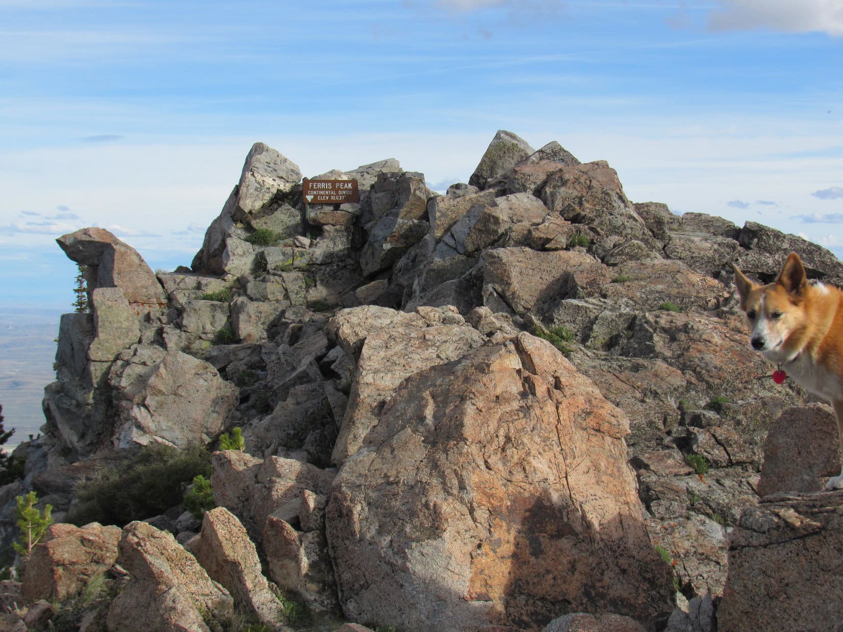


What a tremendous mountain! The views were superb. The weather was vastly improved from what it’d been this morning. Beauty shone forth in every direction in the early evening light. A glorious day! SPHP congratulated Lupe on her grand success, shaking her freckled paw.
Scrambling the short remaining distance to the highest rocks, Lupe came across two survey markers. At the very top, tucked among rocks near the metal sign, she found a plastic jar. Inside was a registry. SPHP was eager to have a look at.
Was it there? Yes, it was! Happy day! SPHP found the entry by Edward Earl.


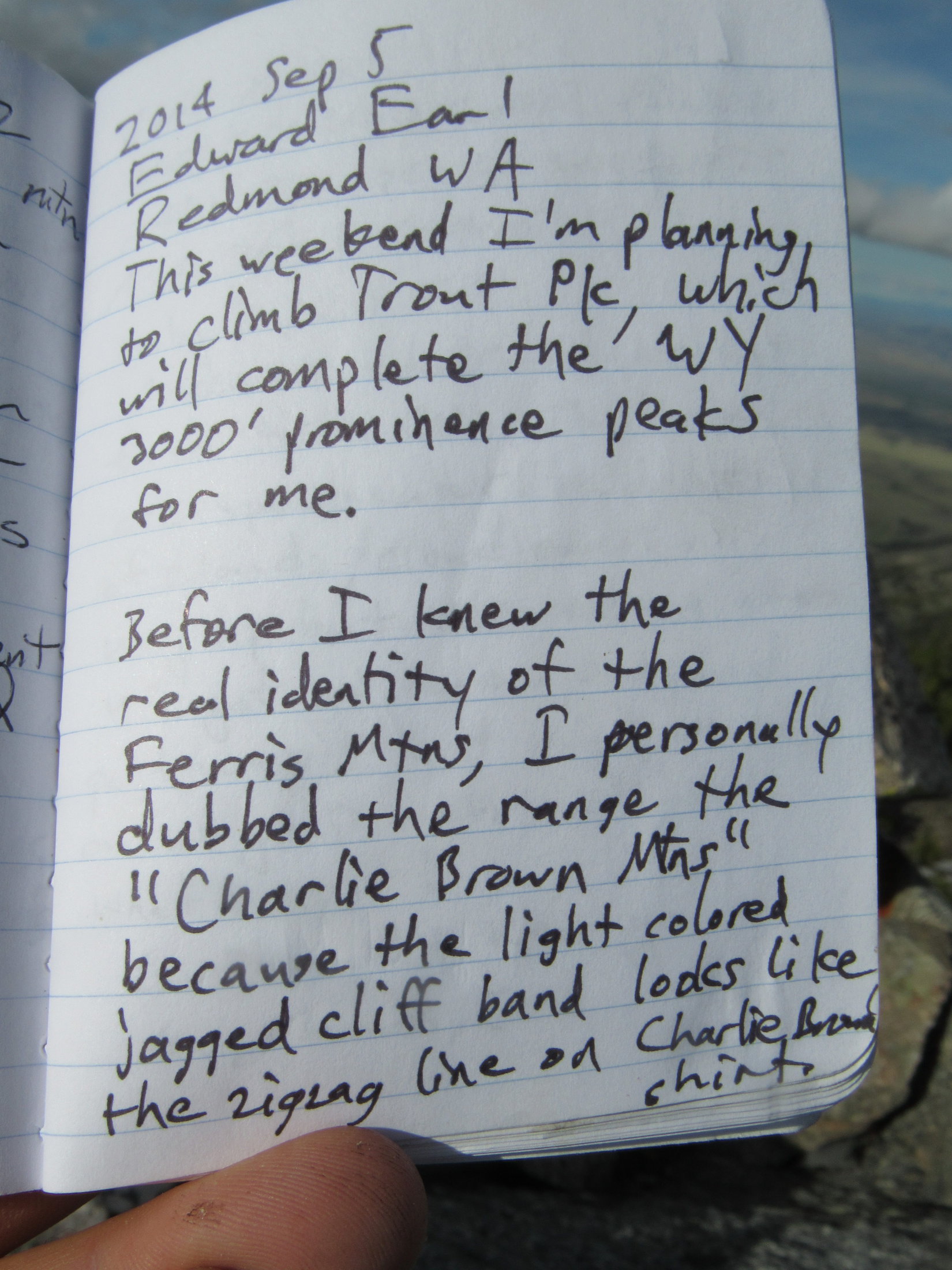
Seeing that Edward Earl had written about the Charlie Brown Mountains made SPHP smile. Lupe had been to quite a few mountains with assistance from Mr. Earl’s detailed trip reports. Once again, she was at the top of a mountain Edward had been to before her. Sadly, Lupe would never get to meet him.
Edward Earl had perished tragically nearly 2 years ago on 6-19-2015, drowned in the rushing Jago River in the Brooks Range in NE Alaska following two failed attempts to climb Mount Isto (8,976 ft.).


Lupe rested among the rocks, while SPHP fiddled with the registry. When SPHP was finally done, it was time to spend a while contemplating the tremendous views.


All too soon, the angle of the sun insisted it was time to move on. Lupe left Ferris Mountain starting back the way she’d come up. SPHP figured the American Dingo still had some time to spare. She revisited the summit of Ferris Mountain Middle.


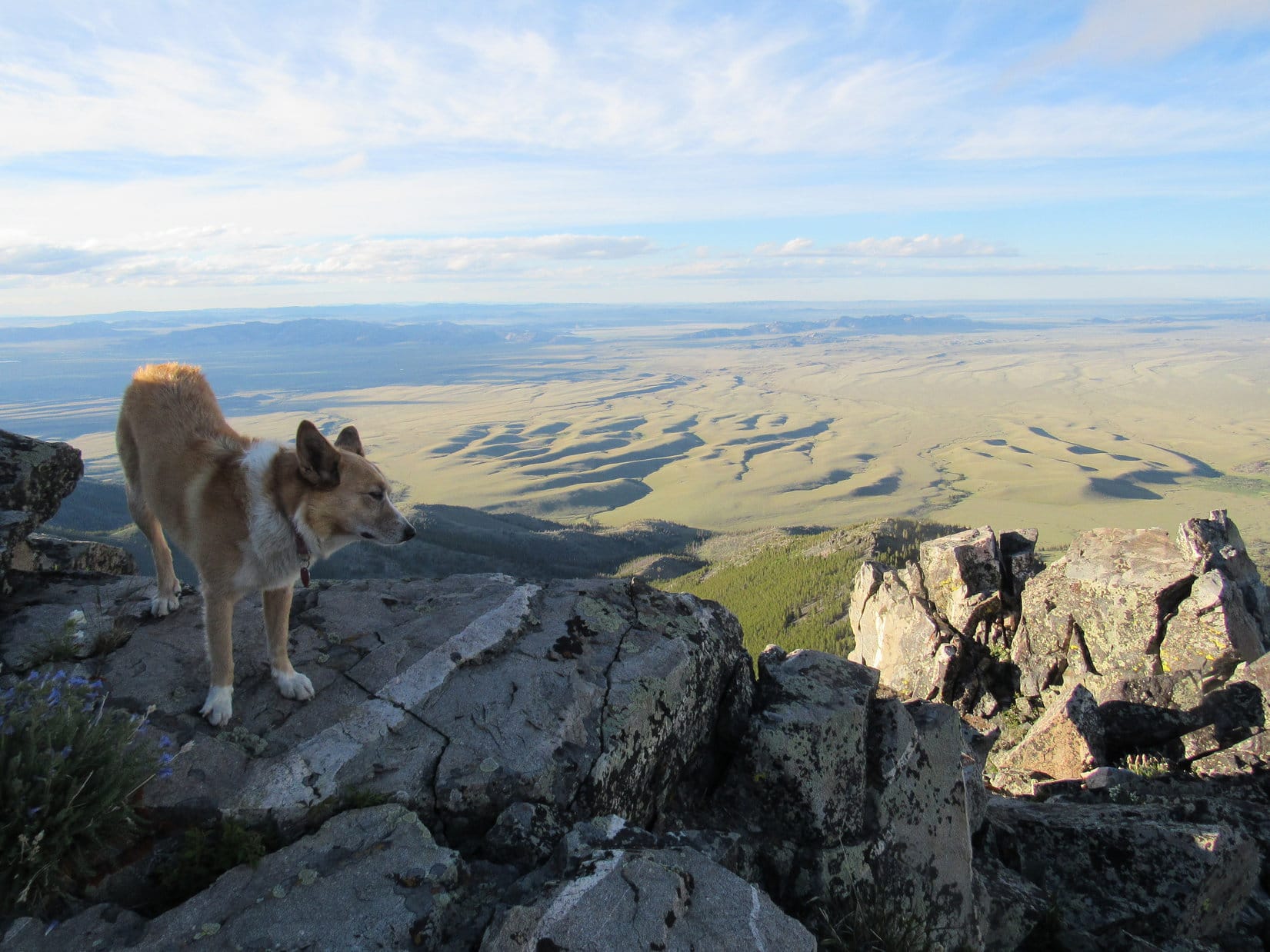
From Ferris Mountain Middle, Lupe went down to the 9,900 foot saddle. She was about to leave the mountain’s main ridgeline. Before continuing down, she took a last look at the huge expanse of prairie S of the Charlie Brown Range.

She then turned her attention to her final peakbagging objective of the day, Ferris Mountain North (9,740 ft.).

Looper headed down to the 9,700 foot saddle leading to Ferris Mountain North. She went N toward the high point. As she got close, she circled around to the E where it wasn’t as steep. Lupe quickly found a rocky route to the top.

To the S, were the forested upper N slopes of Ferris Mountain leading to the ridge where the Carolina Dog had spent the last several hours atop the Charlie Brown Range. To the N, thirsty sagebrush prairie stretched away to distant hills. Shadows of ridges made the land look like ripples on a sea.


Lupe couldn’t linger long on Ferris Mountain North. She was 2 miles from the green metal gate near the mouth of Pole Canyon. Another 7 miles to the G6. After a good look around, and a little time spent in contemplation, Lupe headed back to the 9,700 foot saddle.
Downhill all the way now! The Carolina Dog plunged N down into the E branch of Pole Canyon. The forest was a maze of 3 to 5 foot high snow drifts and deadfall timber, but this route was easier than the way Lupe had gone up. The terrain was only moderately steep, and not too rocky.
Loop soon discovered that the roughest ground was at the bottom of the canyon. For a long way, she stayed E and higher up, sometimes more than 100 feet above the creekbed. The snowbanks shrank and became less numerous, as she lost elevation.
By the time Lupe was low enough so most of the snow was gone, the deadfall wasn’t as bad either. She now made fast progress, which was a good thing. The sun, though still up, was hidden behind the mountains. Sunset couldn’t be too far off.
As Lupe drew near the point where both branches of Pole Canyon converge, the terrain changed. Lupe made her way to the bottom of the canyon, and leapt over to the W side of the creek. She soon came to the stream confluence, and had to make one more crossing. For a while she traveled down Pole Canyon staying W or NW of the stream.
To avoid the larger stream crossings and swampy ground closer to the mouth of Pole Canyon, Lupe eventually got up on the side of the ridge to the NW. Nearing the base of the Charlie Brown Range, she reached the ridgeline. The sun was down, the land dark. Thin clouds glowed brilliantly orange in a pale sky.
The colorful display faded to gray. Lupe managed to reach the green metal gate before it was too dark to see. Still 7 miles to go, but Loop had made it to Pete Creek Road. After crossing the Rush Creek drainage, the road turned N. All gently downhill from here.
Lupe and SPHP marched away from the Charlie Brown Range, never looking back. Only blackness was behind. Ahead, distant headlights on Hwy 220. The infinite universe glittered above.
Every now and then Lupe heard something, and went racing away into the night. Antelope? Rabbits? No telling. Fortunately, the luck of the Dingo held. She always came streaking back, panting happily. No cactus had stabbed her. No rattler had bit her. No wolves had devoured her.
Ferris Mountain had been a fabulous day! Yet, things don’t always go one’s way. Luck can run out. Perhaps weariness, or the silent black night was to blame, but during the long trek back it was hard not to think about another adventurer who had come this way. An adventurer who ultimately helped make this day a success for beloved Lupe, but whose luck had run out nearly 2 years ago.
It was hard not to ponder the life and times, and tragic fate of Edward Earl. (12:05 AM)

Links:
Next Adventure Prior Adventure
Edward Earl’s trip report on his 9-5-2014 ascent of Ferris Mountain
Want more Lupe adventures? Choose from Lupe’s 2017 Laramie Range, Wyoming & Beyond Adventure Index, Dingo Vacations Adventure Index or Master Adventure Index. Or subscribe free to new Lupe adventures.
I really enjoyed this one! I won’t deny that I’m very afraid of rattlesnakes – more for Zoe than myself. Can I ask, do you give Lupe anti-venom treatments? Just curious – it is part of why I don’t go a lot of places with Zoe… Thanks for another great adventure! ~Niesey
Niesey, you’re smart to keep Zoe away from questionable areas. For Lupe’s sake, I fear rattlesnakes more than any other form of wildlife. We normally try to avoid places and conditions where they might be expected. Lupe hasn’t had any anti-venom treatments, though we might check into it this coming spring. Wonder if they have side-effects? Don’t know anyone whose had a dog that’s had them.
I’ve never seen rattlesnakes in the Black Hills above 5,500 feet elevation, which is why we stay pretty high during warm weather. We tend to do lower peaks around the perimeter of the hills only during cold months, in part due to fear of rattlers. However, seeing the rattlesnake Lupe almost ran into at 7,250 ft. at Muddy Mountain this past summer was an eye-opener.
Ferris Mountain was a terrific peak and a fun time, once we actually got away from the long worrisome trek to and from the base of the mountain. Lupe’s glad you enjoyed her post about it! She has more great adventures on the way!
My yorkie gets the snake venom shot every year. Two the first year and booster every year after that, no side effects and might just save his life as there seems to be a lot of rattlesnakes where I live and he is just a little guy. Love Ferris and put many miles on that mountain. First elk and record antelope were killed among others over the years.
Probably a good idea to use the snake venom shot since you live where there are lots of rattlers. SPHP has thought about having me vaccinated at times, but snakes aren’t common around here, although there is definitely a chance to run into prairie rattlers in the lower hills, which we therefore tend to avoid during warm weather. Good to hear that your Yorkie hasn’t had any side effects from the vaccine! I take it he hasn’t ever been bit?
I’ve only ever seen one rattler, and that was at Muddy Mountain near Casper, WY. Sort of disconcerting since it was at 7,500 feet, higher than anything here in the Black Hills.
Ferris Mountain is a great peak! I was lucky to get to go there!
Hi I am reading your report here after hiking Ferris Peak today. Tough hike for us senior citizens. Camping here at base of mountain. I find it amazing that you did the peak from 6 miles away. Great photos. We plan to try Whiskey Peak tomorrow.
Hi, Richard! Good to hear from you! Glad you enjoyed the post. Ferris Peak is a fun one, but yeah, it was a long day. Looks like you made it up Whiskey Peak, and a bunch of others since then, too.
Just got back from my latest Dingo Vacation two days ago. Ought to still be out there, but, gah! – too much smoke!
Hello,
We went up Ferris by Edward Earl’s route and mostly followed Ken Jones’ route down which we thought was a bit better. We didn’t have any trouble with Whiskey Peak and walked the road from about 1.5 miles out. We then did some Utah peaks, one in Idaho and seven in Montana.
Yes, nasty smoke in many areas, but we had a couple clear days.
Thank you for this story and the great descriptive content and photos. I have looked with aspiring thoughts upon those lonesome, wild Ferris Mountains for many, many years and fished Cherry Creek. Now, thanks to you, I know the possibility of getting to climb and explore that beautiful place that has always given me a sense of longing. May your journeys be always blessed with good fortune!
Glad you enjoyed this post, Molly!
Hope you do get a chance to explore the Ferris Mountains now. They are wild and lonesome as you say. Do you live in the area? Sounds like you might.