
Start: 9:20 AM, 36°F at the Boulder Hill trailhead of Flume Trail No. 50 on USFS Road No. 358 (Boulder Hill Road)
Going to Boulder Hill with Mark and Hillary on Expedition No. 219 had reminded SPHP that while Lupe had been to Boulder Hill half a dozen times, she had never been to nearby Storm Hill. Wasn’t it about time she went?
Of course, Lupe was in favor of any idea that would get her out of the house for another Black Hills adventure! Soon she was setting out for Storm Hill (5,192 ft.) from the same Boulder Hill trailhead of Flume Trail No. 50 where she had so recently been with Mark and Hillary.

For the first 0.33 mile, Lupe followed Flume Trail No. 50. The trail went SE up to a saddle between Boulder Hill and Storm Hill. With only an inch of snow on the ground, Lupe could have run around exploring easily enough. Instead, she nervously stuck close to SPHP. Distant gunfire could be heard coming from somewhere off to the W. Someone was doing target practice.

At the saddle, Lupe was between Boulder Hill to the SW, and Storm Hill to the NE. A spur of Flume Trail No. 50 goes all the way up to the top of Boulder Hill, but there isn’t any trail going up Storm Hill. Lupe would have to bushwhack through the forest.
Carolina Dogs love bushwhacking! Despite the distant gunfire, Lupe grew bolder after leaving the Flume Trail. She followed the saddle NE over to Storm Hill. She was going away from the gunfire, which helped her confidence.

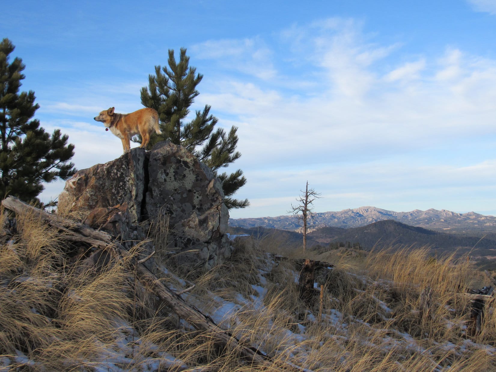
Upon reaching the SW slope of Storm Hill, Lupe traveled right on up a rocky spine of the mountain. The climb would have been easier if she had simply avoided the rocks. However, she did get glimpses of Boulder Hill from the rocks she wouldn’t have otherwise had.


The SW spine of the mountain topped out near the S end of a broader ridge. This broader ridge was also quite rocky, but wasn’t as steep. Lupe gained elevation more slowly as she followed it N. To the E, Loop could see little but forest. However, she did come across places where she had views off to the SW or W.


The summit of Storm Hill was close to the N end of the broad ridge. A fairly large summit area, perhaps 30 or 40 feet in circumference, was the highest part of the mountain. Pine trees obscured the views in some directions. However, Lupe enjoyed a panoramic view to the N and NE from the top of small cliffs.


By moving around the summit area, Lupe found at least partial views in other directions.


Storm Hill has a double summit. Two widely separated areas contained within 5,160 foot contours are on the topo map. Lupe was at the W high point where a site elevation of 5,192 feet was shown. SPHP presumed this was the true summit of Storm Hill. It was hard to get much of a look at the E high point, but there was a spot from which it could be seen.
The E high point was a long, skinny ridge. It was steeper and more rugged-looking territory. The highest parts of the E ridge appeared to be about as high as where Lupe was, but SPHP was pretty certain they weren’t any higher. Satisfied that Lupe had actually reached the true summit of Storm Hill, SPHP didn’t make her spend the extra hour it might have taken to visit the E ridge, too.

Lupe returned to the true summit of Storm Hill, before taking a little break. Meanwhile, SPHP took a few more photos of the views.


Lupe spent 20 minutes enjoying the summit of Storm Hill before moving on. The Carolina Dog started back retracing her route S along the broad ridge. She soon left the ridge, however, veering SW to explore easier terrain in the forest below. She reached Flume Trail No. 50 again well N of the saddle where she’d originally left it.
By 11:06 AM (42°F), Loop was back at the G6. Storm Hill had been fun, but had taken her less than 2 hours. Plenty of time left in the day for more adventures! SPHP drove S. Lupe had fun barking at cows, horses, and eventually even some buffalo. At 1:52 PM (41°F), SPHP parked the G6 at the mouth of a grassy valley N of USFS Road No. 336 (Flynn Creek Road) less than a mile S of Northeast Cicero Peak (6,240 ft.). Lupe had been to Northeast Cicero Peak twice before, but her most recent ascent was now more than 2.75 years ago. For fun, she would try a new route up.
Lupe started out climbing NW up a thickly forested ridge on the W side of the grassy valley. She eventually emerged from the trees. An open hilltop was only a short distance away. Loop went to the top for a look around. She was a little S of High Point 5821. Cicero Peak (6,166 ft.) was in view not quite a mile to the SW.


Continuing onward, Lupe skirted High Point 5821 to the NE. The partially forested slope was so steep, she might just as easily have gone to the top of High Point 5821, but she didn’t. Upon reaching the saddle N of High Point 5821, the American Dingo turned N. She climbed a mostly open slope up to a high grassy area with a commanding view.

From the high grassy area, Lupe headed NE gaining elevation at a slower pace. Most of this part of her climb was in a forest containing scattered lumpy rock outcroppings. In the shade of the pines, snow was several inches deep.
The final approach to the summit from the WSW was a gentle climb up a grassy slope. A N/S running rock ledge only 2 or 3 feet high was at the top of the mountain. A lone boulder sat a short distance beyond the ledge. That boulder, which appeared to be slightly higher than the ledge, was the true summit of Northeast Cicero Peak (6,240 ft.).


The summit area was large and grassy. A few pines along the N edge blocked views to the NW, while a dense forest hid views to the S and SE. In other directions, Lupe could see big swaths of the Black Hills. The most interesting views were of higher country to the N.


A cool W breeze blew. A low, weary sun, partially obscured by a bank of clouds, dangled listlessly above the horizon. Northeast Cicero Peak felt forlorn, sad. Mid-afternoon, but it felt late. Late in the day. Late in the year. Winter solstice was only 3 days away. Christmas soon after that. A week later, 2017 would be over. Another year gone forever. A depressing thought.
Neither Lupe nor SPHP knew it yet, but Northeast Cicero Peak was the last mountain Lupe would climb in 2017.


Northeast Cicero Peak was the highest mountain this far S in the Black Hills. The views were impressive. Yet the somber mood of the mountain made SPHP restless after only 10 minutes on top. Maybe action would add some cheer? Lupe set off into the forest, intent on exploring the mountain’s S ridge on the way down.
The S ridge wasn’t a very good route. It was full of obstacles. Dense stands of young pines, slick snowy spots, rough rock outcroppings, deadfall timber, all the usual rigamarole except fences to deal with. Not much in the way of views as compensation, either. For what seemed like a long way, the Carolina Dog didn’t lose much elevation.

Lupe finally came to a rare open spot in the forest where the going was easier. Beyond it, the descent began in earnest.

Once the descent really got going, it was one steep slope after another. Lupe avoided rocky areas as much as possible, which became progressively easier the lower she went. She eventually turned SW, ultimately reaching the floor of the valley W of the S ridge. Here, the American Dingo found a faint road leading back to the G6 (4:08 PM, 36°F).
The last of 33 Black Hills, SD Expeditions in 2017 was over.

Links:
Next Black Hills Expedition Prior Black Hills Expedition
Want more Lupe adventures? Check out her Black Hills, SD & WY Expeditions Adventure Index, Master Adventure Index, or subscribe free to new Lupe adventures!