
Day 28 of Lupe’s 2017 Dingo Vacation to the Yukon & Alaska!
7:00 AM – Still foggy, but it was light out now. The fog didn’t seem as thick as it had been a few hours ago. Loopster was still snoozing after her big adventure going to Ermine Hill (2,700 ft.) and beyond yesterday up on K’esugi Ridge in Denali State Park. SPHP worked on catching up the trip journal.

When Lupe woke up, SPHP suggested going back to the Ermine Hill trail registration station, which was only a short stroll away through the drippy forest. Lupe welcomed the opportunity to get out and sniff around.
Yesterday, from higher up on Ermine Hill, Lupe had seen two people and a big brown dog down on the trail. They had been watching a black bear across a small lake, before ultimately turning and retreating back down the trail. Lupe had pressed on closer to where the bear was on her way to Peak 3700, but hadn’t ever seen it again. SPHP was curious whether the people had written any comments about the bear in the registry.
The people had written some comments, surprising ones! Their dog’s name was Ollie. That wasn’t so surprising, but what they had written about the bear was. Ollie and his humans hadn’t seen a black bear, they’d seen 5 of them! A sow with 2 cubs, plus 2 more mature bears. No wonder they had retreated back down the trail! K’esugi Ridge had been crawling with bears! Despite roaming around up on K’esugi Ridge practically all day yesterday, Lupe and SPHP had only seen that one.
Even though the fog was slowly thinning, by mid-morning it was fairly certain that Lupe wasn’t going to get to see Denali (20,310 ft.) today. At the pace things were improving, the Alaska Range would never come into view. May as well move on. Lupe and SPHP left Denali State Park taking George Parks Highway No. 3 to Wasilla.
By mid-afternoon, after a couple of stops and going through Wasilla, Lupe was nearing Palmer on Glenn Highway No. 1. It was a beautiful day here, 65°F and fairly sunny. Traffic was backed up for miles. People were thronging in to the Alaska State Fair. The fair wasn’t anything Lupe could go see, but another option existed. There was time enough left in the day to climb Hatch Benchmark (4,811 ft.) from Hatcher Pass.
In 2016, Lupe had climbed nearby Skyscraper (4,825 ft.) from Hatcher Pass under less favorable conditions. She had succeeded then, and Hatch Benchmark should be even easier. The April Bowl trail goes all the way from Hatcher Pass up to Hatch Benchmark passing April Bowl on the way. The trail is only 1.1 miles long, and elevation gain required is only 925 feet, comparable to what Skyscraper had been.
2.25 miles N of Arctic Avenue in Palmer, SPHP turned L (W) on N Palmer Fishhook Road (Willow Fishhook Road on some maps). 19 miles later, Lupe arrived at Hatcher Pass. Not everyone had gone to the Alaska State Fair. The pass was packed with people and vehicles. SPHP was lucky enough to grab a parking spot for the G6 at the same little pullout where Lupe had started for Skyscraper last year. (4:37 PM, 58°F)
A short, dusty walk W along the busy gravel road brought Looper to the official top of Hatcher Pass. The April Bowl trail started right across the road from the Hatcher Pass monument. The trail began by immediately switchbacking up a hillside of light green vegetation.


The switchbacks soon brought Lupe close to a small stream tumbling down a ravine. Loop helped herself to a drink. The trail began climbing more steeply up the E side of the ravine.

As Lupe drew near April Bowl, the trail leveled out to some degree. The summit of Hatch Benchmark came into view.


April Bowl contains 4 separate ponds. Lupe soon reached the first pond where the stream originated. A second pond was in view close to the first one. The trail curved around the E side of the closest pond heading for the long ridge leading to the summit of Hatch Benchmark.


At April Bowl, Lupe had gained over 300 feet of elevation from the start of the trail. She had another 600 feet of elevation gain to go following the high ridge above April Bowl leading to Hatch Benchmark.


Lupe had been meeting many people and dogs on the way up, but by the time she was getting close to Hatch Benchmark, fewer hikers had come this far. Only a small group of people could be seen ahead up at the summit.


5 or 6 people were at the top of Hatch Benchmark when Lupe and SPHP arrived. They remained only a short while before heading back down. Lupe had Hatch Benchmark all to herself.
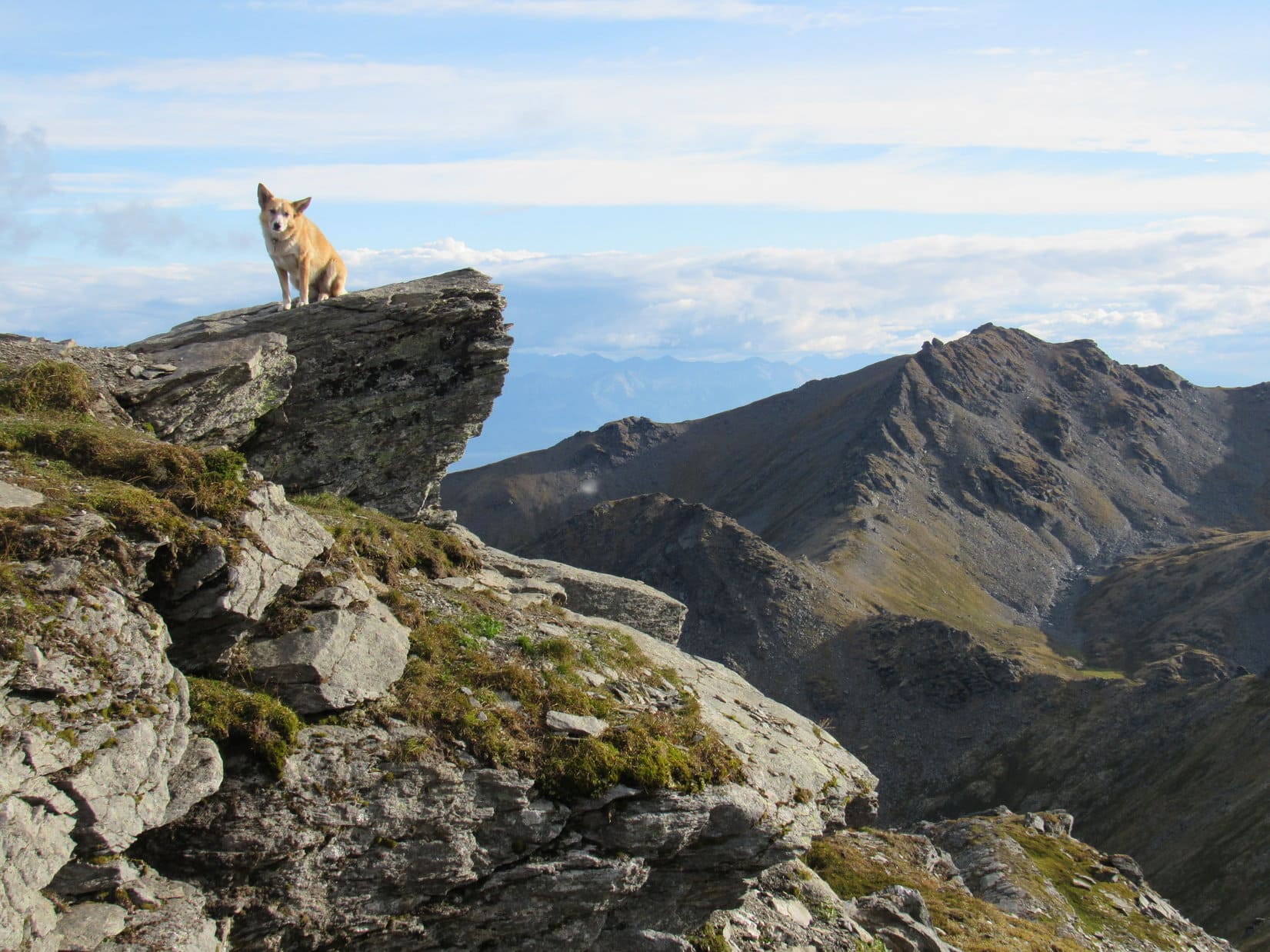
The summit area was triangular in shape. It wasn’t particularly large, but was level and roomy enough to walk around on easily. The two highest points were a couple of large rock outcroppings toward the N and SW separated by about 40 feet. SPHP thought the N high point was the true summit, but they really weren’t much different in elevation.
Views of the surrounding Talkeetna Range were magnificent!


No one else came up the mountain after Lupe, perhaps because it was getting on toward evening. However, the weather was holding up just fine. Temperatures were in the mid 50’s °F. No wind or precipitation. Lupe and SPHP lingered enjoying the views. SPHP searched around for the actual Hatch survey benchmark, but found nothing.
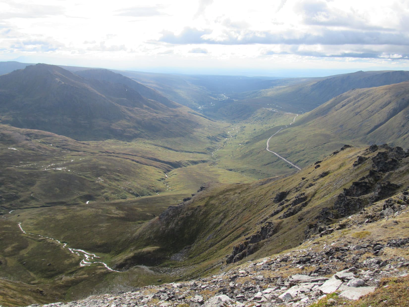
Off to the S, beyond Palmer and the Matanuska River valley, Lupe could see a couple of peaks in the Chugach Mountains she had climbed back in 2016, Lazy Mountain (3,740 ft.) and Pepper Peak (5,381 ft.). SPHP recognized some other peaks the Carolina Dog had never been to, as well.


Lupe was happy to cooperate, and it was so beautiful out that SPHP took lots of photos.


Lupe did great, but she eventually got bored with the photo shoot. She decided to take a break while SPHP made do without her.


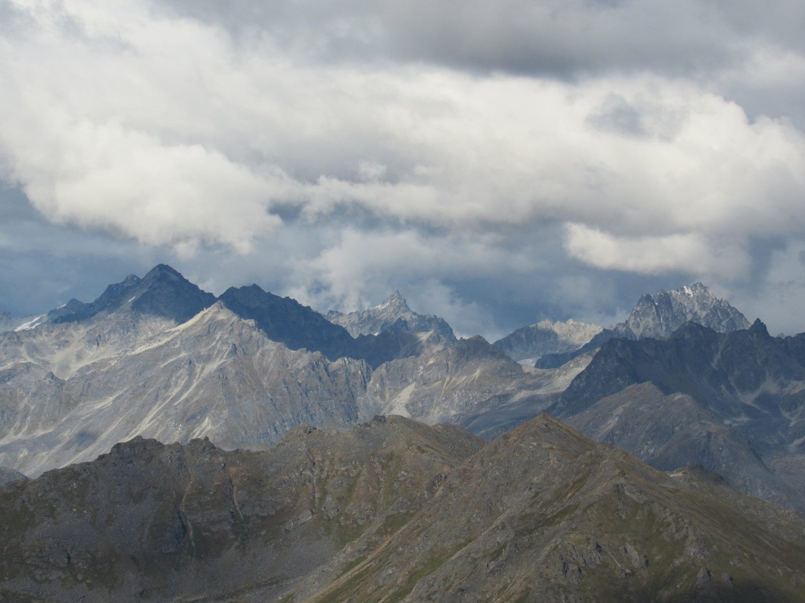
Some of the most spectacular peaks that could be seen from Hatch Benchmark were toward the NE. With the telephoto lens it was possible to get a fairly good look at them. SPHP didn’t know the names of those peaks, but maybe they could be figured out later by comparing photos with maps?

The time came to leave Hatch Benchmark. No one else had come up the mountain. Lupe was ready for a few more photos before departing.


Loopster and SPHP enjoyed the easy trek back to Hatcher Pass. Lupe met far fewer people than on the way up. Everyone was heading down.


Not many vehicles were around when Lupe reached Hatcher Pass again. (7:35 PM) The crowds were gone. The few people who still remained were all busy getting ready to depart. Looper visited the Hatcher Pass monument.

The whole trek from Hatcher Pass to April Bowl and Hatch Benchmark had only taken 3 hours, even with all the loitering Lupe and SPHP had done up at the summit. Loopster was right, it was nice to have an easy time where everything went smoothly for once.
Before long, Lupe and SPHP were alone at Hatcher Pass. Loopster was staying for the show that everyone else was going to miss.
The show was a good one, with beautiful colors. Later there was a half moon, and even a few stars. With all the clouds and fog in Alaska, Lupe hadn’t seen stars in, well, it couldn’t really be forever, but it seemed like a long time. Maybe the stars were a good omen for tomorrow?

Oh, I think you’re right, SPHP! Those are our lucky stars! Tomorrow will be another great day. Just leave all the wildcats to me! I get along fine with cats.
Wildcats? What wildcats, Loop?
The wildcats on the mountain we’re going to, silly! Passels of ’em! Don’t worry, though. I’m always good with cats. They can’t help it that they’re handicapped. It’s no fault of theirs. They were born that way. These lynx wildcats are big, though, so it will be trouble if you rile them up. Just leave ’em alone, and let me deal with them.
I’m not expecting to see any wildcats Loop, handicapped or not. What makes you think we will, or that they will be handicapped if we do?
Oh, for pity sake! Have our plans changed again? Haven’t you been saying we are going to Lynx Peak tomorrow? Didn’t we see a lynx shortly before we left the Dalton Highway a few days back? Wasn’t it a big wildcat? Won’t lynxes be swarming all over Lynx Peak? Of course, they will!
This is starting to sound a lot like Jack Squirrel Peak, Loop. Remember how you got all worked up about the enormous jack squirrels, and then it turned out there weren’t any?
That was terrible, SPHP! A completely awful, sickening tragedy! Don’t you remember why the jack squirrels weren’t there, though? They all burned up! Lynx Peak won’t be burned up. How could it be? It rains on us multiple times practically every day here in Alaska.
That’s true enough. Couldn’t light Lynx Peak on fire, if we tried. Well, I suppose we might see a lynx. Must have been one on Lynx Peak one time or another. Why would it be handicapped, though?
Don’t you humans know anything about animals, SPHP? It would be handicapped because it’s a cat! That’s what cats are! They aren’t good at being members of the pack. They don’t understand how to hunt together and help the pack. They just want to be fed and adored for doing nothing, then left alone. They’re perfectly fine by themselves, and have no social skills other than the ability to train humans to be their servants. Why do you fall for that anyway?
I suppose it’s all the purring, Looper. A purring kitty is hard to resist.
Oh, yeah. Their one magic trick. That noise isn’t natural, though, SPHP. Nothing else does that. Suspicious, don’t you think? Something’s not right about it. Makes me wonder if they aren’t really handicapped? Maybe they made some deal with someone they shouldn’t have ever been dealing with in the first place. Maybe if their purrers were exorcised, they would be normal dogs again?
Normal dogs again? Cats aren’t dogs!
Sure they are! Why, we had them in my family when I was born. We were all there, cats and dogs together! One big happy family. We got along fine. That’s why I understand cats so much better than you do. Cats are just a different sort of dog. Handicapped, like I said before.
Alright, whatever Looper. You win. I’m just going to hope for a nice day tomorrow like the lucky stars are predicting. You can deal with the passels of lynxes for us.
Good! Remember this – when we get to the lynxes, don’t do anything that makes them wag their tails. When us Dingoes and normal dogs wag our tails, it means we like you. When cats wag their tails, it means they are thinking about eating you. The faster and twitchier they wag them, the hungrier they are, too! So watch their tails.
Wonderful advice, I’m sure, Loopster. But I don’t think lynxes even have tails, or at least not much of one.
No tails? Even stranger than most cats then. They might be more dangerous than I thought. Just stay close, and try not to look like a big mouse.
Fine, fine, whatever you say. I ought to be able to manage that!

Related Links:
Skyscraper Mountain, Talkeetna Range, Alaska (8-22-16)
Hatcher Pass East Management Area
Want more Lupe adventures? Choose from Lupe’s 2017 Dingo Vacation to the Yukon & Alaska Adventure Index, Dingo Vacations Adventure Index or Master Adventure Index. Or subscribe free to new Lupe adventures.