Day 30, Part 2 of Lupe’s Summer of 2016 Dingo Vacation to the Canadian Rockies, Yukon & Alaska
Flashing lights. SPHP slowed down, pulling over toward the shoulder to let the cop go past. Instead, the patrol car came right up behind the G6. Uh-oh. SPHP had been driving 10 mph under the limit. Now what? Lupe started to growl as the policeman approached SPHP’s window. Not a good time for that, Looper! Shush!
Burnt out headlight. Which one? The right one. Good grief. That same headlight had burnt out a few weeks before Lupe left home on this Dingo vacation. SPHP had personally bought and installed a new bulb. Most aggravating.
The officer politely gave SPHP a $50 fix-it ticket. Fix it within 30 days and have the headlight inspected by an Alaskan state trooper, or pay the fine. Sigh. Well, onward. Nothing could be done about it on a Sunday evening. Loopster, that was an adventure we could have done without.
The adventure Lupe was on her way toward was the trail to Portage Pass to see the Portage Glacier. Only a few days ago, Lupe had seen Portage Lake and taken a nearby trail to see the Byron Glacier. However, Portage Glacier long ago receded from view from the NW end of Portage Lake where Lupe had been. To see it, Lupe would have to go through the Anton Anderson Memorial Tunnel (also known as the Whittier Tunnel), and take the trail to Portage Pass.
At 13,300 feet long (2.5 miles), the Anton Anderson Memorial Tunnel is the longest highway tunnel in North America. The tunnel is only a single lane wide, and highway vehicles share it with the Alaskan Railroad. Railroad tracks are embedded right in the highway lane.
Logistically, the tunnel functions on a set schedule, with highway vehicles getting to use the tunnel for 15 minutes in each direction each hour. The 15 minute intervals alternate directions every 30 minutes. The tunnel is not open to highway vehicles at night. During 2016’s summer schedule, the first time slot in the morning was 7:00 – 7:15 AM. The last time slot in the evening was 11:00 – 11:15 PM.
Lupe timed her arrival at the Whittier Tunnel perfectly! SPHP paid the $13.00 round trip fee for the G6 at the toll booth. Only a minute or two later, Lupe had a green light to enter the tunnel.
The 2.5 mile long Anton Anderson Memorial Tunnel to Whittier was more fun and spooky than Lupe expected!
The maximum speed limit was only 25 mph, so it took a while to get through the tunnel. It was spookier and more fun than Lupe expected! It was a little like going down a long dungeon passage in a video game, except there were no side doors, passages, turns or curves at all. (No wandering monsters, either!) The tunnel was completely straight.
In a few places, water dripped from the ceiling. At intervals, there were small pullouts for vehicles experiencing mechanical difficulties. Otherwise, no stops are permitted. If a train had been coming from the other direction, the Whittier Tunnel would be the stuff of nightmares.
The tunnel was a little like being in a long dungeon passage in a video game, except there were no side doors, passages, twists or turns at all. The Anton Anderson Memorial Tunnel is completely straight.
Of course, the tunnel’s carefully controlled schedule prevents head on collisions from happening. Still, it was an odd feeling when, upon emerging from the tunnel, Lupe saw a locomotive aimed directly at the passage she had just taken.
Lupe was now on the Whittier side. Only a short distance (0.25 mile?) from the end of the tunnel, was a R turn onto a gravel road that promptly went over the railroad tracks. This was the short road leading to the Portage Pass trailhead. Another R turn led to a lane where vehicles were parked along both sides of the road. It was a strange trailhead with no formal parking lot. At first, SPHP wasn’t even certain Lupe was at the right place.
This was it, though! SPHP parked the G6 (7:02 PM, 57°F). Tall bushes dominated the area, and out of them flooded a horde of tiny black flies. Standing around meant getting chewed on by these little menaces. Lupe and SPHP looked around for the trail to Portage Pass, finding it near a sign. Lupe set off up the trail at once.
The Portage Pass trail was relatively busy, with people and dogs coming and going. Most were leaving at this time of day. Tall bushes grew everywhere off the trail. Biting black flies were everywhere, too. They weren’t too bad, as long as Lupe didn’t stop to look around. Going up the trail to Portage Pass, there really wasn’t much to stop and look at anyway, although the view back toward Whittier and Passage Canal was steadily improving as Lupe gained elevation.
The trail to Portage Pass is only a mile or so long. The trail is popular, so it was well-worn and in good condition. It starts close to sea level, and gains nearly 800 feet of elevation. Most of the way, it climbed steadily at a moderate pace. As Lupe neared the pass, the climb became steeper. The annoying black flies did an excellent job of discouraging any needless dawdling along the way.
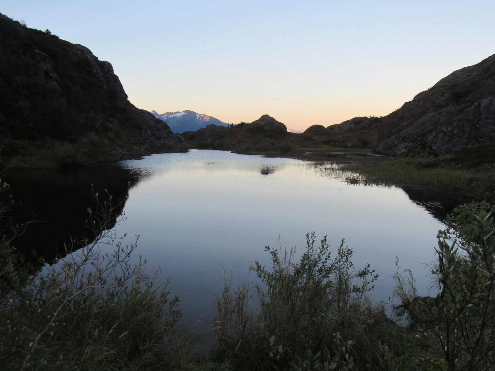
Thankfully, a breeze was blowing up at the pass, largely solving the black fly problem. Ahead were magnificent sights!
Lupe arrives at Portage Pass. Ahead were magnificent sights! Photo looks SW.
Coming up, Lupe had been in the shadow of Maynard Mountain(4,137 ft.), but beyond the pass, snow-covered mountains gleamed in the evening sunlight. Beautiful Portage Glacier was directly ahead a mile or more away. Big waterfalls cascaded down nearby mountains from snow fields and smaller glaciers.
From Portage Pass, Lupe saw snowy mountains in the evening sunlight. Photo looks S.
A maze of small trails climbed a variety of hilly rock formations and small ridges in Portage Pass. Lupe climbed up for a better look. A small pond known as Divide Lake was ahead to the SW. Divide Lake sat lower down on a broad, brushy flat area, beyond which Lupe saw Portage Glacier extending all the way down to the far shore of Portage Lake.
Lupe on a rocky high point in Portage Pass. She had a fabulous view of the Portage Glacier from here! Photo looks SW.Beyond the lower small pond known as Divide Lake, Portage Glacier could be seen flowing all the way down to the far shore of Portage Lake. Photo looks SW.Portage Glacier. Photo looks SW using the telephoto lens.The Portage Glacier still reaches Portage Lake, and still calves icebergs into it. The glacier will not have to retreat much farther, though, before icebergs in Portage Lake will be a thing of the past. Photo looks SW.Lupe was fortunate to see the Portage Glacier on such a clear day. Nearby Whittier has 196 inches of average annual precipitation, including 241 inches of snowfall. Yeah, might want to bring the raingear, just in case.The Portage Glacier was far from the only beautiful sight from Portage Pass. Here, Bard Peak(3,800 ft.) and part of the much smaller Shakespeare Glacier are in view on the L. Photo looks SSW.
A trail continues beyond Portage Pass all the way down to Portage Lake, which is another mile away. Unfortunately, Lupe had arrived too late in the day to go that far. However, while she was up at Portage Pass, Lupe met Matt and Elisa from Nome. They decided they wanted to go at least to Divide Lake, so Lupe and SPHP tagged along, too.
From Divide Lake, it wasn’t possible to see the lower part of the Portage Glacier where it reaches Portage Lake. However, Lupe did have beautiful double views of the upper portion of the glacier and surrounding peaks reflected in the lake
Lupe saw the upper portion of the Portage Glacier and surrounding peaks reflected in mirror smooth Divide Lake. Photo looks SW.
Lupe at Divide Lake. Photo looks SW.
Lupe, Matt, Elisa and SPHP went a little beyond Divide Lake, eventually reaching a bench. Bushes had grown up so much, anyone sitting on the bench no longer had a view of the Portage Glacier. SPHP could see it, but only by standing on top of a big rock nearby. Lupe saw only bushes in the direction of Portage Glacier, but she could still see big waterfalls on the mountains to the S.
From the bench beyond Divide Lake, Lupe could still see big waterfalls on the mountains to the S, although she had no view of the Portage Glacier. Photo looks S.SPHP could see the Portage Glacier only by standing on a big rock next to the bench. However, this was a slightly better view than Lupe had had back up at Portage Pass. More of Portage Lake and some of the icebergs in it could be seen. Photos looks SW.In late August 2016, Portage Glacier barely reached Portage Lake.The impressive waterfalls Lupe could see to the S made a distant, soothing roar.Through the telephoto lens.
Matt and Elisa talked about life in Nome. Elisa told of having to call in late for work sometimes due to herds of musk oxen blocking the road. Elisa was the first person Lupe or SPHP had ever met who had this problem. There can’t be too many places in the world where musk oxen in the way would be a well-received excuse for being late to work.
Byron Peak (4,700 ft.) and the Portage Glacier near sunset. Photo looks SW.A final close look at the Portage Glacier ice viewed through the telephoto lens.
Sunlight was rapidly disappearing. Soon it would be gone even from the mountaintops. Lupe, Matt, Elisa and SPHP all started back for Portage Pass. At the pass, Matt and Elisa went on, but Lupe tarried. From another rocky hill in the pass, Lupe had a beautiful view of Passage Canal back toward Whittier.
Looking across a small pond in Portage Pass in the opposite direction from the Portage Glacier. Photo looks NE.Lupe near a cairn on one of the small rocky hills in Portage Pass. She had a tremendous view of Passage Canal back toward Whittier! The top of Lowell Peak(L) is still sunlit for a few more moments. Photo looks NE.Lowell Peak(4,728 ft.) from Portage Pass. Photo looks NE using the telephoto lens.
A few late stragglers were still heading up the Portage Pass trail as Lupe headed back down to the G6. Before long, it would be too dark for them to see much of anything at Portage Pass. Most of the time, the trail was deserted. Lupe arrived back at the G6 (9:17 PM).
Even though it was getting dark, Lupe and SPHP drove into the town of Whittier, to see what it was like. Whittier was a strange place. There were few homes, and only a small run-down looking business district. Three high-rise buildings were perched up against the base of towering mountains, but only one of them was lit up.
On a Sunday evening, there wasn’t much going on, but it was easy to see that Whittier must ordinarily be a busy place. There were lots of commercial buildings around. Large parking lots were crammed full of vehicles and boats. Down by the shore, a great many boats were moored along illuminated docks in a cove of Passage Canal. Multiple railroad tracks ran through town.
The whole place had an abandoned industrial air to it, though what could be seen of the setting was spectacularly beautiful. Did Lupe want to spend the night stuck in Whittier? No, probably not. There was still time to make the 10:00 PM tunnel access back out of Whittier to the rest of the world.
So Lupe left spectacular Portage Pass, and the odd, beautifully situated town of Whittier behind. She made one more spooky trip trip through Anton Anderson Memorial Tunnel, emerging from the far end beneath a starlit Alaskan sky.
Passage Canal from Portage Pass near sunset. The strange little town of Whittier is out of sight along the cove to the R.
Day 30, Part 1, of Lupe’s Summer of 2016 Dingo Vacation to the Canadian Rockies, Yukon & Alaska
No Dingoes allowed! Extraordinarily disappointing, but the place was swarming with tourists. Park rangers patrolled near the nature center at the start of the trail. Signs banning American Dingoes were prominently displayed. There wasn’t going to be any getting around this one. Lupe couldn’t go. Time to break out Plan B.
The day had started out well enough, with sunny skies full of promise. A gorgeous drive from the Mystery Hills almost all the way to Seward had taken up the morning. Lupe enjoyed beef stew for breakfast along clear, rushing Ptarmigan Creek. Now here she was, all ready for her next big adventure.
That big adventure was supposed to have been a hike from the Exit Glacier Nature Center along the Harding Icefield Trail all the way to the end. Lupe would have had a sweeping view of the 700 square mile Harding Icefield, the largest icefield entirely within the United States. Now it was clear that wasn’t going to happen.
What SPHP hadn’t realized was that the Exit Glacier and Harding Icefield are in Kenai Fjords National Park. Since US National Parks are forbidden territory for Carolina Dogs, Lupe’s Harding Icefield adventure was over before it started. At least Lupe had gotten to see the Exit Glacier from a distance on the way to the nature center.
At least Lupe did get to see this view of the Exit Glacier on her way to the nature center. Unfortunately, she was banned from the Harding Icefield Trail where she would have had a fabulous view of the 700 square mile Harding Icefield. Photo looks W.
Fortunately, there actually was a Plan B. Lupe could go to Tonsina Point on Resurrection Bay! Compared to the Harding Icefield Trail, Plan B wasn’t too ambitious, but maybe that was OK. Yesterday, Lupe had a big adventure in the Mystery Hills involving more than 3,000 feet of elevation gain. Perhaps an easy day was for the best.
SPHP drove back along Herman Leirer Road (the road to the Exit Glacier) to mile 3 on the Seward Highway, turned S, and drove all the way through Seward to a “T” at the end of the highway at the S end of town.
A right turn took Lupe to a gravel road perched slightly above the W shore of Resurrection Bay. The dusty road went S for 3 miles to Lowell Point, where it curved to the E. There was private property in Lowell Point, and signage didn’t mention Tonsina Point. Which way? SPHP had no clue, but stayed on the same road.
The road made another turn to the S. Happily, it soon ended at a trailhead. (Note: $5.00 daily parking fee). A path could be seen leading from the parking lot to Resurrection Bay, only a short distance away. This must be it! SPHP parked the G6 (12:48 PM, 72°F), and Lupe got out. Lupe and SPHP took the short path to Resurrection Bay.
The temperature was in the low 70’s °F, no doubt a warm day in Alaska, but SPHP was surprised to see Lupe had arrived at a public beach. Even more surprising was that a few hardy Alaskans were actually in the water. Resurrection Bay is an arm of the North Pacific Ocean. Streams and rivers pour glacial meltwaters into it. How warm could it be? Those Alaskans must be tough! Neither Lupe nor SPHP was tempted to take a dip.
To SPHP’s surprise, Lupe arrived at a public beach on the S side of Lowell Point. A few tough Alaskans were swimming in these glacial fed waters of the North Pacific Ocean! Photo looks NE.
Ixnay on the swimming, but a little sunbathing might be enjoyable. The beach certainly had a wonderful view of Resurrection Bay and the surrounding mountains, many of which still had snow or even small glaciers visible on them. Offshore, a small island rose dramatically from the bay. A large bird was perched up on top. It looked like it might be an eagle.
From the beach at Lowell Point, a small rocky island rose dramatically from Resurrection Bay. A large bird, perhaps an eagle, was perched on top. Photo looks SSE.
The camera’s telephoto lens revealed the truth. The big bird actually was an eagle – a bald eagle!
The big bird actually was an eagle – a bald eagle! Now that was cool!
While SPHP wouldn’t have minded dozing and sunbathing on the beach at Lowell Point for a little while, the truth is, American Dingoes aren’t much into that sort of thing. Lupe wanted action! So Lupe and SPHP headed SW toward the end of the beach, where SPHP expected to find the trail to Tonsina Point.
The beach ended at a very steep forested embankment coming all the way down to the sea. No sign of a trail anywhere. Puzzling. SPHP finally concluded it was best to return to the trailhead for information on the trail’s location.
As it turned out, there were two trailheads, the one the G6 was parked at near the beach, and another trailhead for the Caines Head State Recreation Area. The second trailhead was only a short hike away up a hill. The trail to Tonsina Point starts from there. Lupe and SPHP left the G6 parked where it was, taking a muddy trail through an amazing forest up to the second trailhead.
Note: The Caines Head State Recreation Area trailhead has its own parking lot at the end of a short road (a R turn to the S) off the Lowell Point road from Seward. There was a sign for it, but SPHP hadn’t made the turn since the sign didn’t mention Tonsina Point. The same $5.00 daily parking fee applies here.
A sign at the upper trailhead showed a map of Caines Head State Recreation Area. The trail to Tonsina Point is only the first short section of a much longer trail to destinations near Caines Head. Lupe was only going as far as Tonsina Point. Beyond Tonsina Point, parts of the trail are flooded and impassable at high tide, possibly forcing an overnight stay waiting for low tide.
Map posted at the Caines Head State Recreation Area trailhead.
The trail going S to Tonsina Point and beyond started as a single track at the parking lot, but soon merged with a road leading to private properties, which seemed a bit weird. Farther on, it left the private road, continuing as a 5 or 6 foot wide trail improved with a layer of fine slate gray gravel.
All the way to Tonsina Point, the trail went through a thick forest providing not even a glimpse of Resurrection Bay. Tiny streams flowed next to the trail in some places, providing Lupe with fresh, cold water. The trail was relatively busy on this warm day in August, though it was a ghost town compared to the crowds Lupe had seen at the Exit Glacier.
After leaving the private road, the trail climbed steadily at an easy pace, ultimately gaining about 200 feet of elevation. The trail then became more primitive and switchbacked down a considerably steeper slope. At the bottom of the switchbacks, Lupe arrived at an arched bridge over Tonsina Creek.
Lupe on the bridge over Tonsina Creek. Photo looks upstream (W).
From the bridge, Lupe had a great view downstream of Tonsina Creek emptying into nearby Resurrection Bay.
From the arched footbridge, Lupe had a great view of Tonsina Creek emptying into nearby Resurrection Bay. Photo looks E.
Once across the bridge, Lupe left the main trail to follow a path toward Resurrection Bay, stopping briefly to wade in Tonsina Creek along the way. Salmon could be seen swimming in the creek. Signs near the main trail indicated fishing for them was prohibited.
Lupe hadn’t been interested in swimming in Resurrection Bay back at Lowell Point, but she didn’t mind wading in Tonsina Creek.Loopster near the mouth of Tonsina Creek where it empties into Resurrection Bay. Photo looks NE.
Lupe had arrived at Tonsina Point, the big delta formed by Tonsina Creek where it reaches Resurrection Bay. Being a delta, the whole area was flat. Away from the ocean, above the high tide mark, bright green grasses and other plants flourished in luxurious profusion. The tidal plain close to Resurrection Bay was all sand, mud and small stones. Seagulls congregated near the edge of the water.
When Lupe arrived, the tide was at least partially out, exposing a large stretch of tidal plain beyond the onshore vegetation. Lupe went way out near the water’s edge to check out the impressive views of Resurrection Bay and surrounding mountains.
From Tonsina Point, Lupe could see a glacier in the mountains on the E side of Resurrection Bay. Photo looks ENE using the telephoto lens.Snow remained on many mountains, even though Lupe was here in late August. Photo looks ESE.Seagulls liked to hang out near the edge of the bay. Photo looks SSE.
The 1.5 mile long trail Lupe took to Tonsina Point starts at Lowell Point, seen on the L. Lowell Point is about 3 miles S of Seward, Alaska. Seward is situated at the far NW end of Resurrection Bay. Photo looks NNE.
Several old tree trunks, bleached white by the sun, were washed up near the high tide mark. People were using them as benches, from which they had great views of Resurrection Bay while relaxing and having lunch. That seemed like a good idea, so Lupe and SPHP headed over there to join them. On the way, Lupe found something on the beach which greatly interested her.
Lupe thinks dead fish are really cool! SPHP isn’t as keen on them. The Carolina Dog sometimes likes to roll in stinky things like dead fish, probably an instinctive action to hide her scent. Boy, does that ever work!
At the bleached tree trunks, SPHP took a break and had a bite to eat. Lupe wasn’t tired or hungry. She met a dog named Pinecone, and spent her time enticing Pinecone to play with her, at which she was partially successful.
After SPHP’s break, Lupe continued her exploration of Tonsina Point’s tidal plain, working her way around toward the S. A very large piece of driftwood with many branches was stranded out there all by itself. Lupe sniffed around it, and decided it made a good, scenic platform for her next couple shots of Resurrection Bay.
Lupe goes out on a limb to present you with this beautiful picture of Resurrection Bay from Tonsina Point! Photo looks SSE.Out on a limb! Oh, SPHP, you’re such a riot!
Near the S end of Tonsina Point, Lupe’s advance was blocked by another channel of Tonsina Creek. The main trail crossed this channel at a 2nd bridge located farther inland. Lupe went over to the 2nd bridge, but did not cross it.
At Tonsina Point, Lupe had only seen a small portion of Caines Head State Recreation Area. The main trail continues S beyond the 2nd bridge for miles leading to more trails, an old fort, various facilities, and lots more beautiful views. No doubt it was all worth further exploration, however, the tide was starting to come in. At high tide, parts of the trail S of Tonsina Point are under water.
Lupe and SPHP were not prepared to spend the night camping out, if Lupe got cut off from Tonsina Point by high tide. So Lupe took the main trail back N through a lovely forest to the 1st bridge over Tonsina Creek.
Lupe in the forest on the Tonsina Point delta.On the trail back to the first bridge. Photo looks N.Lupe squints in the bright sunlight on the 1st bridge over Tonsina Creek. Photo looks N.
Lupe’s time at beautiful Tonsina Point was over. She had only scratched the surface of what there is to see at Caines Head State Recreation area, but Tonsina Point had been an easy, fun excursion. Lupe returned to the G6 happy with her Tonsina Point experience (3:47 PM).
Before leaving the gorgeous Seward area, Lupe played tourist in town. She dropped by a park where a statue featuring a prospector and his dog commemorates Alaska’s pioneering spirit, and the Iditarod National Historic Trail, which goes all the way from Seward to Nome. Lupe shares Alaska’s pioneering spirit. She was certain the statue could be improved by the addition of an American Dingo.
The 1.5 mile long trail to Tonsina Point was lovely, but American Dingo, Lupe, was ready for a bigger challenge on the 958 mile Iditarod Trail going from Seward to Nome! Unfortunately, SPHP wasn’t up to it, and chickened out.
Lupe was enthused. She was all for setting out on the 958 mile long Iditarod Trail, but SPHP just doesn’t have quite the same degree of Alaskan pioneering spirit and chickened out.
Well, fine. Lupe had another idea. How about something less pioneery, and more decadently luxurious? There was a big, comfy ship in town that looked like it could take Lupe and SPHP to Nome in grand style by sea. American Dingoes love being pampered, too, you know!
Since SPHP wasn’t up to the Iditarod Trail, Lupe was also willing to consider a luxurious sea voyage to Nome aboard this very spiffy Holland America cruise ship.
SPHP had to admit the cruise ship was beautiful and would be a lot of fun, but whined piteously something negative about a budget. Most disappointing, but Lupe finally did manage to negotiate a consolation deal.
After a stop at Safeway, Lupe left Seward in the G6, perched in comfort high up on her blankets and pillows, heading N on a wonderful scenic drive along the Seward Highway while sharing ice cream sandwiches and chips with SPHP. Before the day was over, she was going to get to go through a long, long tunnel and take the trail to Portage Pass to see the Portage Glacier.
Of course, that’s another adventure for another post.
Tonsina Point on Resurrection Bay, Caines Head State Recreation Area, Alaska
Day 29, Part 2, of Lupe’s Summer of 2016 Dingo Vacation to the Canadian Rockies, Yukon & Alaska
Plans for a return visit to the beach at Ninilchik on Cook Inlet were quickly dashed when Lupe and SPHP stopped to help a woman hitchhiker along the Sterling Highway (Alaska Route 1). Turned out she needed a ride to her landscaping job, well beyond Ninilchik, clear over in Soldotna. She was already late and needed to get there quickly. Her car (nowhere in sight) had broken down, and no one else had stopped to give her a lift.
Jane was a friendly, plucky gal. She introduced herself to Lupe and SPHP, and immediately launched into her life’s story. Some of it made not a lick of sense, but it was an entertaining tale nevertheless. Lupe and SPHP listened in silence as the miles flew by, and Jane related her only-in-Alaska monologue.
Jane had moved to Homer, Alaska from California years ago. Naturally, she loved Alaska. She had made some money back in California in real estate. Jane used part of the money she’d saved to make a great purchase of 40 acres near the edge of a development somewhere around here, the particular parcel having been carefully selected by closing her eyes and putting her finger to a map.
The land wasn’t even for sale at the time, but when Jane approached the owners, they thought she was so wonderful, they promptly agreed to sell it to her for a song. She lives off-grid in a cabin on this beautiful property, where she and her dog manage to avoid being eaten by grizzlies by sticking close to either the cabin, or her ATV, on which they zoom away to safety at a moment’s notice.
When you live off grid, you have to create your own entertainment. Jane kept chickens to produce eggs. A pure white rooster served as head of the flock. For fun, Jane used a water pistol to paint the rooster with bright colors so he was more of a fancy rainbow rooster instead of a boring pure white one. The rooster didn’t object in the least. Instead, his reaction was to put on a Mick Jagger style strutting performance to impress his harem, which Jane found endlessly amusing.
Sadly, tragedy struck. All but two of her chickens and the beloved rainbow rooster passed away very recently when her pet wolf broke its new chain after only 2 days, and did what wolves like to do to chickens.
With the wonderful, balmy climate Alaska now has due to global warming, it’s getting harder and harder to keep the riff raff out. The Kenai peninsula is filling up with people. Living off the grid here is no longer the hardy pioneering existence it once was a few years back. Fortunately, Jane’s 24 year old son took pictures of a mind-bogglingly beautiful little town, with a name that SPHP has since forgotten, but it started with a “U”.
U-ville is located on Spruce Island, near much larger Kodiak Island, and can only be accessed by boat or the air. The few pictures Jane’s son took were enough to convince Jane that U-ville is the place to be, so she is in the process of getting ready to sell her 40 acres and move. People in U-ville, who have never met Jane, but have advanced word of her interest in living on Spruce Island, are falling over themselves offering her good jobs, and encouraging her to join their community ASAP.
Jane related all this, and a good deal more which now escapes SPHP, in the time it took to reach Soldotna, where she promptly exited the G6, cheerfully bidding Lupe and SPHP a fond farewell. Clearly there had been much more to come, time permitting, so it was with a mixed sense of reluctance and relief that Lupe resumed her own adventures, though they may pale in comparison to Jane’s.
Lupe’s next adventure started E of Soldotna near milepost 61 of the Sterling Highway at the trailhead for the Skyline Trail to the Mystery Hills (12:03 PM, 68°F). The trailhead parking lot was on the SW side of the highway, but the actual trail started over on the NE side, a bit farther to the NW.
Looking up at the Mystery Hills from the Skyline Trail parking lot near milepost 61 of the Sterling Highway. Photo looks NE.
A sign near the start of the Skyline Trail provided general information. Lupe could expect a steep 1,800 feet of elevation gain over 1.25 miles.
The Skyline Trail is somewhat oddly named, since it officially ends at a saddle between mountains, before ever getting up to any of the peaks of the Mystery Hills, or even following any portion of the ridgeline. Skyline Access Trail would have been a better name for it.
The sign did show a trail continuing on up from the saddle. On the topo map SPHP had along, a pack trail goes on for miles all the way from the saddle up to and over a series of peaks in the Mystery Hills.
Sign near the start of the Skyline Trail.
Just as the sign had promised, the Skyline Trail was steep. There were no significant switchbacks. Up and up. SPHP was soon pausing frequently to let heart, lungs and legs catch up with the demands of the trail. Lupe, of course, wasn’t fazed in the least.
For a long way, the trail was in forest. Little could be seen. After quite a climb, the forest finally started gradually giving way to tall bushes. Lupe started to get glimpses of the progress she was making.
Once the forest thinned out, Lupe could see the progress she was making. Part of her first peakbagging goal, Mystery Hills North is seen on the R. Photo looks E.
The trail’s rate of climb didn’t diminish until Lupe was getting fairly close to the saddle. Then things started to level out rapidly. Where Lupe first reached the saddle, she came upon a final big stand of gnarled old pine trees. The day was warm and bright. The shade provided by this last clump of odd old pines was welcome. Lupe and SPHP took a break.
As near as SPHP could tell, Lupe had reached the official end of the Skyline Trail.
Lupe takes a break beneath an isolated stand of gnarled old pines she came upon as she reached the saddle. She was at, or very near, the official end of the Skyline Trail.
The Skyline Trail may have officially ended, but the sign and maps were right. A good trail continued on across the saddle toward the mountain to the E. (Note: As far as Lupe was concerned, this continuation of the trail going on up to the Mystery Hills was all part of the same Skyline Trail, and will be referred to as such for the remainder of this post.) When Lupe’s break under the gnarled pines was over, Lupe and SPHP pressed onward.
Not far from the pines, Lupe passed by another trail branching off to the N on its way through the saddle. The American Dingo ignored the side trail and started climbing the mountain to the E.
A good trail continued beyond the gnarled pines across the S end of the saddle area. Lupe ignored a side trail that branched off to the N (L), and continued up the hill seen directly ahead. This extension of the Skyline Trail eventually climbed around to the S (R) side of the hill. Photo looks E.
Lupe still had nearly 1,000 feet of elevation gain to go in order to reach her first peakbagging goal, North Mystery Hills(3,284 ft.). She encountered a short stretch of rock climbing near the base of the mountain, but was soon easily past it. Lupe came to no further complications along the trail, which now worked around to the S side of the slope, as it continued E. Another higher saddle could be seen ahead.
Lupe on her way up to a higher saddle(Center). Lupe was heading for North Mystery Hills, seen on the R. Photo looks SE.
On the way to the next saddle, Lupe already had some splendid unobstructed views.
Lupe already had splendid views on her way up the Skyline Trail to the next saddle. Jean Lake is in the foreground. A portion of much larger Skilak Lake is in the distance. Photo looks S.Far away across Cook Inlet, Lupe could see impressive snow-capped peaks. Photo looks NW using the telephoto lens.
The path up to the higher saddle was a long, steady grind, but the pace of elevation gain wasn’t bad, certainly nothing like Lupe had faced on the way to the first saddle. Upon reaching the higher saddle, the trail turned S, climbing more aggressively up the mountain.
When the Skyline Trail finally started leveling out, a rock outcropping larger and higher than any other nearby point was a short distance ahead. Lupe went over to it. She had reached the N end of the North Mystery Hills summit ridge. The views were fabulous!
Here, at the end of the climb up from the 2nd saddle, Lupe reached the N end of the North Mystery Hills summit ridge. A metal box containing a register was tucked among the rocks on the E (R) side of this high point. (Close to the backpack.) The unnamed peak in the background is nearly as high as North Mystery Hills and is located on the other (N) side of the 2nd saddle Lupe had just come from. Photo looks N.Looking down on Peak 2851 (L) from North Mystery Hills. Peak 2851 is on the NW side of the first big saddle Lupe reached where she took a break among the gnarled old pines. Flatlands of northern Kenai Peninsula are seen in the distance. Photo looks NW.Hideout Hill(2,869 ft.) from North Mystery Hills. Part of Skilak Lake is seen in the distance. Photo looks SW.
Right away, Lupe discovered a metal box tucked among the rocks on the E side of the rock outcropping. The box contained a register. SPHP entered Lupe’s name on it to secure the Carolina Dog’s place in North Mystery Hills history.
Although it had been a warm, calm, sunny day lower down, a fairly strong, cool E wind was blowing up here. While SPHP was entering her name in the register, Lupe found a big rock to hide behind. She curled up on the W side of it to escape the wind.
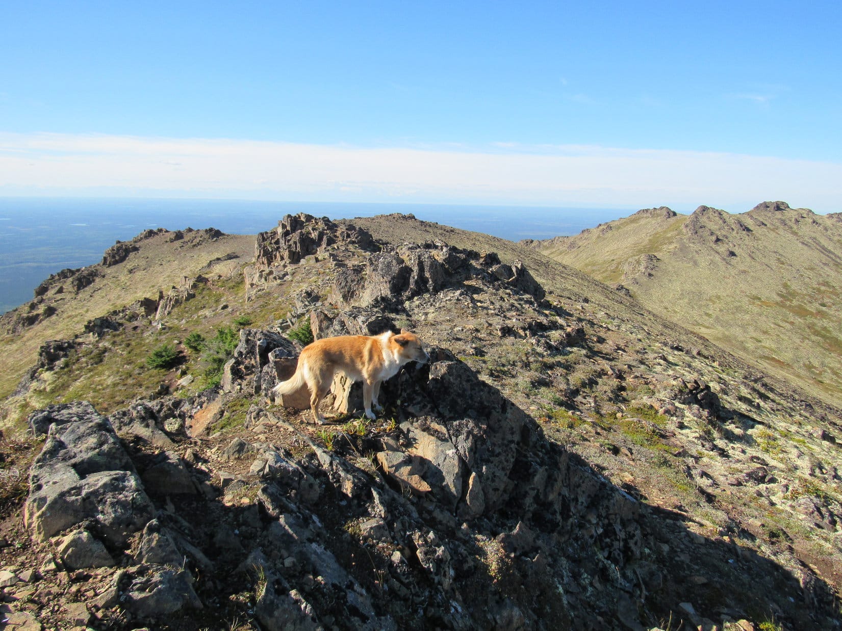
While SPHP entered her name in the register, Lupe curled up behind a big rock to escape the E wind. Lupe hadn’t quite reached the true summit of North Mystery Hills yet. The true summit is the high point beyond Lupe on the L. The similarly colored more distant hill is her next peakbagging goal, Mystery Hills Central. Photo looks SE.
Lupe had seen a number of people along the Skyline Trail, but hadn’t come across anyone since leaving the first saddle. However, while she was still curled up out of the wind, and SPHP was busy gazing off into the distance, a young man showed up. His name was Patrick Metzger.
Patrick was quite friendly to Lupe and SPHP. Soon, Patrick and SPHP were engaged in conversation. Patrick wasn’t an Alaskan native. He moved to Soldotna a few years ago, where he works for Univar, a global chemical distribution business. Like Lupe, he enjoys the outdoors and climbing mountains in his spare time, so there was a lot to talk about.
Patrick shared his love of Alaska with Lupe and SPHP. He recommended several places Lupe might want to consider visiting while she was here. By the time Patrick needed to move on, nearly an hour had gone by. The visit with Patrick had been fun, but Lupe needed to get going, too.
Technically, Lupe still hadn’t reached the true summit of North Mystery Hills, but it wasn’t far away. A short, windy stroll to the SE brought Lupe to the NW end of a small hill on the broader ridgeline. The small hill proved to have two high points on it, one at each end of a little ridgeline, sort of a minor summit ridge up on the greater summit area. Lupe visited both high points. It was a close contest, but the true summit seemed to be at the SE end where Lupe found a small cairn.
Lupe reaches the NW high point on the minor summit ridge. This point was in contention with another spot nearby to the SE for true summit of North Mystery Hills. Mystery Hills Central is on the L. The SE end of Skilak Lake is on the R. Photo looks S.Lupe stands in the wind at the NW high point of the minor summit ridge. This might possibly have been the true summit of North Mystery Hills, but the high point in view to the SE (Center) appeared to be marginally higher. Photo looks SE.
The trail didn’t even go to the likely true summit at the SE end of the minor summit ridge. Instead, the trail skirted below it to the SW. Lupe left the trail to make the short side trip to the true summit. A pitifully small cairn was the only indication Lupe had finally reached her North Mystery Hills(3,284 ft.) peakbagging goal.
Success! Lupe sits in the E breeze at the true summit of North Mystery Hills. Her next peakbagging goal, Mystery Hills Central, is in view along the ridgeline. Photo looks SSE.Looking back to the NW from the North Mystery Hills true summit. The other candidate for true summit at the NW end of the minor summit ridge Lupe is on is seen straight up from her rump. The high point where she first reached the broader summit ridge is at the far end straight up from her head. That’s over where Lupe found the metal box containing the register.Mystery Hills East(3,478 ft.)(Center) from North Mystery Hills. Mystery Hills East is the highest of the Mystery Hills. The trail Lupe was following (an extension of the Skyline Trail) goes all the way to Mystery Hills East, but Lupe didn’t make it that far. Peeking over the R shoulder of Mystery Hills East is Round Mountain(3,901 ft.). Photo looks ESE.
Having finally reached the summit of North Mystery Hills, Lupe’s next objective was Mystery Hills Central(3,291 ft.), still 1.25 miles away to the SSE. Getting there was simply a matter of following the Skyline Trail on a beautiful, fun ridge hike. Lupe had splendid sweeping views along the entire route. She passed over a series of rocky highpoints, as well as lower, gentler terrain, on the way.
Looking back at the summit of North Mystery Hills on the way to Mystery Hills Central. Photo looks NNW.Lupe takes a break on a rocky high point on her way to Mystery Hills Central. Her ears point up toward Mystery Hills East. Photo looks E.Approaching Mystery Hills Central. Photo looks SSE.
When Lupe arrived at the top of Mystery Hills Central, she found a roomy, nearly flat, summit area. It also had two candidates for true summit, separated by only a short distance. Lupe found a survey benchmark at the E high point, and a modest cairn at the W one.
Despite the still rather annoyingly strong E wind, Lupe and SPHP paused on Mystery Hills Central for a while to appreciate the grand 360° views.
The survey benchmark on Mystery Hills Central.Kenai River valley from Mystery Hills Central summit. Photo looks SE.Lupe enduring the stiff E wind up on Mystery Hills Central. What a tremendous view of Skilak Lake to the SW!Looking S toward distant glories of the Kenai Peninsula.S using the telephoto lens.
The topo map showed the Skyline Trail continuing on from Mystery Hills Central, looping around for miles, still following the ridgeline. Eventually the trail goes all the way to Mystery Hills East(3,478 ft.). Lupe could see part of the trail from above.
One look was enough to convince SPHP that Lupe didn’t have the time, and SPHP didn’t have the energy, to press on to Mystery Hills East. That part of the trail had some serious elevation gains and losses along the way, in addition to being nearly another 3 miles long.
The trail to Mystery Hills East can be seen below on the hill on the R. It follows the ridgeline, eventually going over the next hill toward the L. Round Mountain is in view in the distance on the L. Photo looks ESE.
So this was it, Lupe had come as far along the Skyline Trail as she was going to. Mystery Hills Central was the end of the line. The sun said Lupe would soon have to start back. Lupe and SPHP lingered a little while longer together on Mystery Hills Central.
Lupe at the Mystery Hills Central cairn. The ridge route back to North Mystery Hills (Center) is beyond her. Photo looks NW.View to the NE.The Kenai River on its way to Skilak Lake. Photo looks SW.
The time came to say good-bye to Mystery Hills Central. Lupe started back the way she had come.
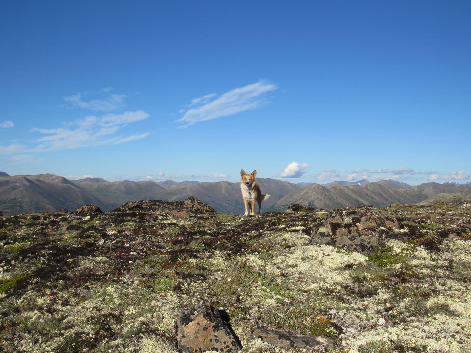
Starting back toward North Mystery Hills (Center). Photo looks NNW.The Mystery Dingo of the Mystery Hills up on the ridgeline. Photo looks E.
As the sun sank lower toward the horizon, the E wind finally began to relent, losing some of its strength. Lupe had a wonderful time exploring the ridge along the Skyline Trail. It was a relaxing evening trek, surrounded by beauty on all sides, high in the Mystery Hills.
Lupe returned to the true summit of North Mystery Hills. From there, she went on to the NW end of the broad summit ridge, back to the high rocky point where she had first discovered the metal box containing the register, and met Patrick Metzger only 4 hours ago.
Lupe returns to the true summit of North Mystery Hills. Photo looks NW.Back at the far NW end of the North Mystery Hills summit area. Lupe is at the high point where she found the metal box containing the register, and met Patrick Metzger a few hours ago. Photo looks NNW.Looper in the evening sunlight, prior to starting back down the Skyline Trail from North Mystery Hills. Photo looks N.Lower Peak 2851 is partially hidden by the slope on the R. The Skyline Trail can be seen leading back down this slope on its way from the high saddle to the first saddle where the stand of old gnarled pines was. The Sterling Highway is on the L. Photo looks NW.
Although Lupe hadn’t seen anyone on the Skyline Trail after Patrick left, once Lupe began her descent from the Mystery Hills, she met a few hikers on their way up. They were hoping to catch the sunset from North Mystery Hills. To SPHP, it looked like the sun was going to sink into a cloud bank. The sunset was likely to be more silver and gray than colorful.
Looking WSW on the way down to the first saddle. Skilak Lake can be seen beyond Hideout Hill on the L. A silvery Cook Inlet shimmers on the far horizon.Jean Lake and more distant Skilak Lake. Photo looks SW.
What those hikers actually saw at sunset, Lupe never knew. By then she was far down steep Skyline Trail in the encroaching gloom of the dark forest at the base of the Mystery Hills. (8:49 PM)