
Lupe and SPHP first came to explore the Absaroka-Beartooth Mountains of NW Wyoming and S Montana in August, 2012 on Lupe’s first ever big summer Dingo Vacation. Lanis had been along then, too. Lupe and SPHP were completely enthralled with these beautiful mountains full of alpine lakes, streams and forests, and eager to return in 2013.
This glorious long day hike starts at Island Lake (elevation 9,518 ft.) in NW Wyoming and gains less than 1,000 ft., with a high point of around 10,360 ft. on a ridge reached N of Jasper Lake shortly before arriving at Two Bits Lake. Lupe and SPHP found no discernable trail the last part of the hike beyond Jasper Lake. The hike passes just E of Lonesome Mountain, the highest peak Lupe has ever climbed to date (6-23-15), although she didn’t climb it until 2014, about a year after making the hike that is the subject of this post.
Clicking on this blue Lonesome Mountain link will take you to the Peakbagger.com page for Lonesome Mountain which features a topographic map of this area. Clicking on this red Lonesome Mountain link will take you to Lupe’s blog post on climbing Lonesome Mountain in 2014.
The Island Lake trailhead is near the Island Lake campground on the N side of Beartooth Highway No. 212 in NW Wyoming. (Both use the same access road off the highway.) The Island Lake campground is approximately 2 miles E of the Top of the World Store & Motel or roughly 15-20 miles E of Hwy 212’s junction with the Chief Joseph Scenic Byway, Hwy 296. Lanis & SPHP purchased topographic maps of the area at the Top of the World Store in 2012.
Lupe woke up early on the 3rd day of her 2013 Dingo Vacation to the Beartooths and Canadian Rockies. She and SPHP had spent the night in the G6 due to rain, after having claimed their favorite camping spot on the Clark’s Fork of the Yellowstone River the day before. It was early, but already light out. The sky was mostly cloudy, but it was no longer raining or even threatening to rain. Lupe and SPHP got out of the G6 eager to greet the new day in the Beartooths.

Swarms of mosquitoes were eager to greet Lupe and SPHP, too. Lupe and SPHP beat a hasty retreat back into the G6. Lupe snoozed another 30 minutes while SPHP made journal entries. Eventually a squirrel woke Lupe up and she just had to get out to bark at it. She buried the only “Minties” bone SPHP has ever given her under a tree near the tent. SPHP resolved to retrieve it after checking out the maps for a place to go exploring.
Back in August, 2012, Lupe, SPHP and Lanis had taken a fabulous hike from the Island Lake trailhead to Beauty Lake and then doubling back to a side trail to Becker Lake. SPHP decided exploring the area above tree line beyond Becker Lake would be great fun for Lupe. By 10:00 AM, Lupe was setting out on the trail from Island Lake. Lupe passed by lakes she had first seen with Lanis in 2012 including Island Lake, Night Lake and Flake Lake. Lupe was making great progress along the trail, partly because mosquitoes became a big problem anytime SPHP stopped for even a few moments.
SPHP was watching for a side trail angling to the right that led to Mutt & Jeff Lakes and then went on to Becker Lake and beyond, and yet somehow missed it. When the trail started to curve to the left and rapidly lose elevation, SPHP remembered it was about to descend to Beauty Lake. SPHP realized Lupe had gone too far. Lupe and SPHP turned around and went back in search of the side trail to Becker Lake and beyond, and this time found it. Upon reaching Mutt & Jeff Lakes, SPHP knew for certain Lupe was headed in the right direction.
Mutt & Jeff Lakes are very close together. The trail goes between the two lakes, crossing a broad connecting stream. There is no bridge, but there are quite a few rocks in the stream and stranded bits of grassy or bushy land. SPHP managed to hop across from rock to rock without getting non-waterproof boots too wet. Lupe had no problem leaping from one rock to the next, or just wading through enjoying the cold, clear water.
Once across the stream, the trail turns NE and crosses a boulder field that extends right down to the NW shore of Jeff Lake. Past Jeff Lake, the trail heads N up a small headwall and then along the E side of a shallow pond (more boulders here) in a saddle.


Soon after passing the saddle, a portion of the S end of Becker Lake came into view. Lupe followed the trail N through the woods well above the E shore of Becker Lake. Towards the N end of Becker Lake, the trail was out in the open and closer to the lake.
There were just scattered groups of trees around as Lupe and SPHP left Wyoming N of Becker Lake and entered Montana on the way to Albino Lake. The trail stayed on the E side of the stream coming down from Albino Lake to Becker Lake. The last few trees were at Albino Lake (10,000 feet elevation), which is situated just E of Lonesome Mountain. Lupe loved the open ground of the high country, although without trees there was the drawback of no more squirrels to bark at.


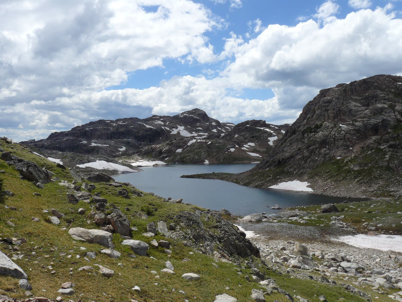
At the SE end of Albino Lake, Lupe crossed over the outlet stream (easy rock hopping) to the W. Lupe and SPHP went up on a hill just S of Albino Lake for a look back towards Becker Lake. Then Lupe followed the trail NW above the W shore of Albino Lake up to the next big saddle ridge ahead. From the saddle was Lupe’s first view of Jasper Lake. The area around Jasper Lake was completely devoid of forest. Rock, heather, scattered patches of snow and sky was all there was. Gorgeous high mountain terrain was everywhere.


Lupe and SPHP were not alone, however. Soon after reaching the saddle with a view of Jasper Lake, a troop of backpackers came traipsing up the trail from the NW. Lupe ran over to greet them, but they soon passed on by. The rest of the afternoon, Lupe and SPHP saw no one. After a break enjoying the view of Jasper Lake, Lupe and SPHP continued NW on the trail, which went down to the outlet stream from Jasper Lake near the SW corner of the lake. This stream had a lot of flow in it.

SPHP didn’t want to get wet feet, so Lupe and SPHP followed the S shore of the stream down all the way to Golden Lake, which wasn’t far off to the WSW. There was no place to cross and stay dry anywhere along the way. There was nothing to be done, except take the plunge. SPHP and Lupe forded the stream at the delta where it enters Golden Lake. Now on the N side of the stream, Lupe and SPHP headed back up towards the W shore of Jasper Lake. Nearing the lake again, Lupe turned N heading for a ridge.


Lupe and SPHP gained the top of the ridge NNW of Jasper Lake at a broad shallow saddle. The saddle area and beyond consisted of rolling terrain strewn with a mix of boulder fields, grassy areas and small shallow lakes. Crossing this ridge, Lupe reached her highest elevation of the day at somewhere between 10,360 and 10,400 feet. Beyond the ridge was Two Bits Lake. Lupe spotted a snow drift and ran down to cool off in it not far from the lake.


Just S of Two Bits Lake, Lupe and SPHP stopped for a break. Lupe chowed down on some Taste of the Wild. SPHP celebrated success with a Coke. After the break, Lupe and SPHP explored among the rocks above the S shore of Two Bits Lake.
Consulting the topo maps, SPHP really wanted to climb another ridge NW of Two Bits Lake and then turn N to find High Pass with the ultimate goal of reaching Sky Pilot Lake. However, the day was wearing on and it was a long way back to the G6. It was too late in the day to try it. If Lupe was ever going to reach Sky Pilot Lake, she would have to come back to Island Lake and start all over again earlier in the day.


After suitable time spent admiring pretty Two Bits Lake, Lupe and SPHP followed a rock ridge SW from the lake. Just to the NW was the outlet stream from Two Bits Lake running down to Triskele Lake. When Lupe reached Triskele Lake it was time to turn back. Lupe headed back up to the saddle area on the ridge NNW of Jasper Lake. The view of Lonesome Mountain and Jasper Lake was just awesome. Lupe saw a bald eagle fly over Jasper Lake heading E.


SPHP wanted to go around the E side of Jasper Lake to avoid having to ford the big outlet stream again. On the NE side of Jasper Lake, Lupe found a big feather near a little stream. Perhaps it was from the bald eagle? That was pretty cool! There were lots of streams coming into Jasper Lake from the E, but since they were smaller, SPHP managed to stay mostly dry getting across them. Eventually Lupe and SPHP reached the ridge to the S of Jasper Lake and found the trail again.


The rest of the evening was spent retracing the trail back to the G6. Lupe and SPHP had seen very few people all day, but on the way back SPHP did stop to talk to a fisherman on the W side of Albino Lake. He was catching mostly 8-12″ cutthroat trout, but said he had caught a couple of 18-20″ cutthroats up at Golden and Jasper Lakes. The fisherman was from Pennsylvania. He claimed to have seen a white wolf.
Lupe reached the G6 again at 11:28 PM. Lupe had been sniffing and exploring for 13.5 glorious hours! By now, though, both Lupe and SPHP were about totally played out. The weary dingo hopped into the G6 and curled up for a snooze. SPHP drove back to the campsite at the Clark’s Fork of the Yellowstone River. Arriving well after midnight, SPHP was just too tired to set things up in the tent. SPHP covered Lupe with a blanket. Another night was spent in the G6. The next morning, a bleary-eyed dingo was still curled up, happily snuggled in the blanket.

Although Lupe did not get as far as Sky Pilot Lake this time, 3 days later she returned and did find it. Click on this Sky Pilot Lake link to see her post on that adventure!
Links:
Next Adventure Prior Adventure
Want more Lupe adventures? Choose from Lupe’s 2013 Beartooths & Canadian Rockies Adventure Index, Dingo Vacations Adventure Index or Master Adventure Index. Or subscribe free to new Lupe adventures.