Hunt Mountain & Bald Mountain, Bighorn Range, Wyoming (6-13-18)

Day 5 of Lupe’s 2018 Dingo Vacation to the Bighorn Mountains of Wyoming & Beyond!

Oh, this was going to be a cinch!  USFS Road No. 10 had been rough, but the G6 had made it.  SPHP parked near the road’s highest point.  (11:33 AM, 53°F)  When Lupe hopped out, she was at 10,000 feet elevation.  She could already see Cloud Peak (13,167 ft.), mightiest of the Bighorn Range, far to the SE.

Hunt Mountain (10,162 ft.), the American Dingo’s immediate peakbagging objective, was only 0.67 mile W of the road.  From this direction, a traipse up a gradual, treeless slope to the summit was mere child’s play.   Good thing, too.  After yesterday’s long march to Dry Fork Ridge and back, SPHP was, well, call it “low energy” today.

Hunt Mountain as seen from USFS Road No. 10 about 3 or 4 miles S of Highway 14A on the way to Lupe’s departure point. Photo looks SW.
Cloud Peak (Center) from close to where the G6 was parked along USFS Road No. 10. Photo looks SE with considerable assistance from the telephoto lens.

A 10 to 15 mph W breeze was blowing as Loopster set out for a small rock outcropping visible a short distance W of the road.

Hunt Mountain from the small rock outcropping. Photo looks W.

From the rocks, a broad drainage area at the base of a big snowdrift was seen sloping gently to the NE.  In order to avoid any wet terrain, Lupe turned SW gaining elevation slowly.  Following the high ground, a big arc could be made around to the NW when she got closer to the W edge of Hunt Mountain.

Lupe delighted in frolicking on a snowbank she found in a depression.

Lupe enjoys a refreshing moment on the snowbank she discovered in this depression. Cloud Peak (L) is on the horizon. Photo looks SSE.

The W face of Hunt Mountain drops off very sharply.  As Lupe got close to the edge, she found fortification-like rock formations standing along the brink of a line of cliffs.

Fortification-like rock formations stood perched along the W edge of Hunt Mountain. Photo looks WNW.
Near the W edge of Hunt Mountain. Photo looks SSW towards High Point 10,015.

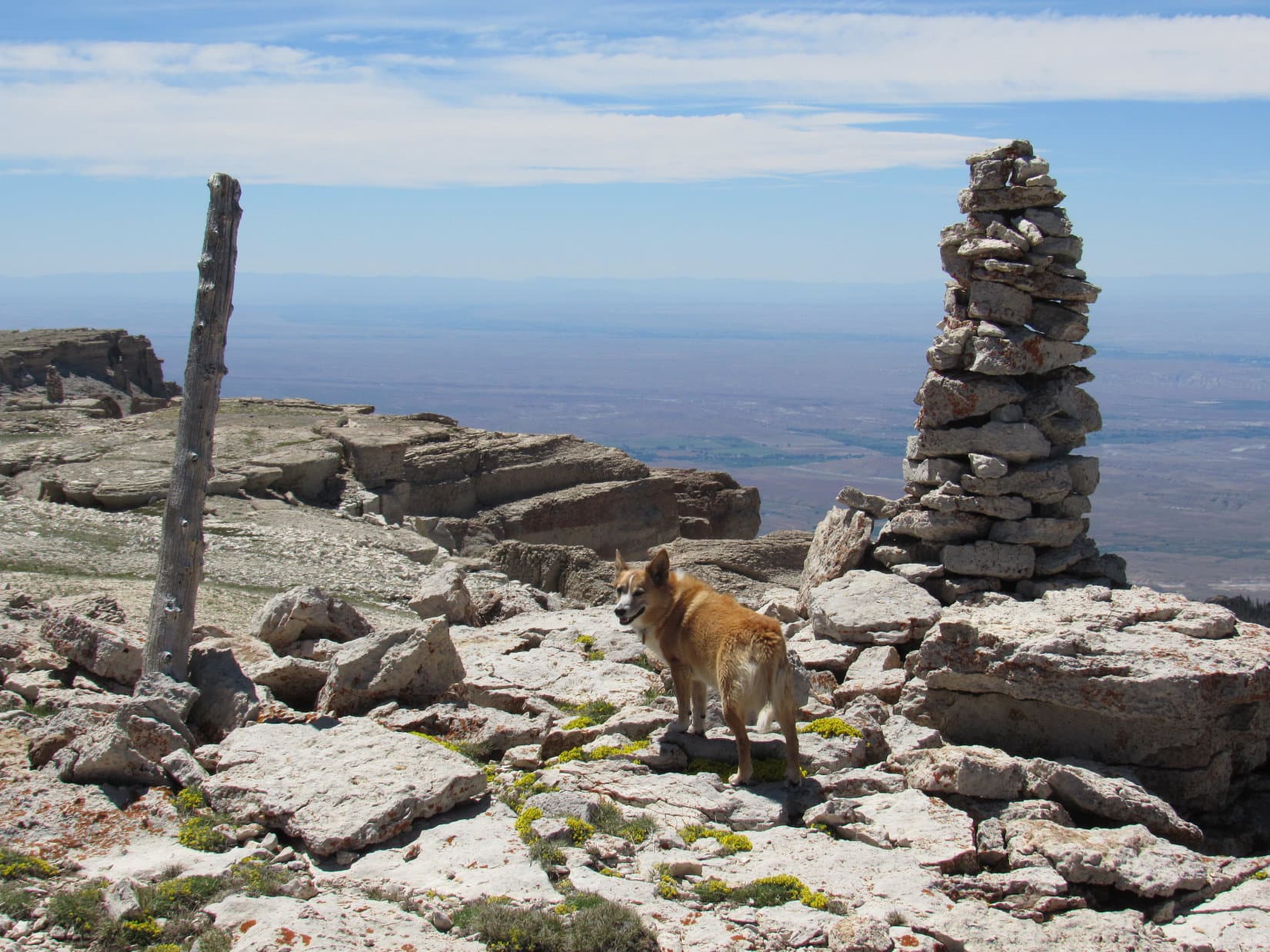
The summit of Hunt Mountain was still a little farther NNW.  Traveling toward it, Lupe could soon see a tall cairn ahead.

Traveling NNW along the W edge of Hunt Mountain a tall cairn (R) came into view. Photo looks NNW.
Getting closer. Photo looks NW.

The tall cairn had a commanding view of a huge amount of territory W of the Bighorn Range.  However, upon reaching it, Lupe could see that this first cairn was not at the top of Hunt Mountain.  Another higher cairn was in sight farther N.

The tall cairn had a commanding view of a vast territory W of the Bighorn Range. Photo looks SW.
From the first cairn, a second, higher cairn (R) could be seen. Photo looks N.

Approaching the second cairn, Lupe came upon a sinkhole.  Apparently parts of Hunt Mountain were hollow!

Loop discovers a sinkhole S of the 2nd cairn. Photo looks N.

The second cairn proved to be the summit of Hunt Mountain (10,162 ft.).  With nothing to obstruct the views in any direction, Lupe enjoyed magnificent scenery everywhere she looked.

At the summit. Photo looks SW.
A wider view of the summit area looking WSW.
Looking WNW with help from the telephoto lens.
Looking N.
Bald Mountain (10,042 ft.) is L of the cairn. Duncum Mountain (9,831 ft.) is on the horizon at Center. Photo looks NNW.
Cloud Peak (13,167 ft.) (Center). Photo looks SE.
Black Tooth Mountain (13,005 ft.) (L) and Cloud Peak (Center) with lots of help from the telephoto lens. Photo looks SE.

The view to the NW was of particular interest.  Lupe could see Bald Mountain (10,042 ft.) and more distant Medicine Mountain (9.962 ft.), both of which she had been to before.  In fact, she intended to visit Bald Mountain again later on today.

At the summit of Hunt Mountain. Medicine Mountain (Center) is on the far horizon. Bald Mountain (R) streaked with long snowbanks is a bit closer. Photo looks NW.
Bald Mountain with help from the telephoto lens. Lupe intended to make her 5th ascent of Bald Mountain later this afternoon. Photo looks NW.
Medicine Mountain (R). The white sphere is part of an FAA installation. Medicine Mountain is the site of the Bighorn Medicine Wheel. Photo looks NW with help from the telephoto lens.

Although sparse vegetation gave Hunt Mountain an overall barren look, tiny wildflowers decorated the summit.  Orange lichens grew on many of the whitish stones.  A knob of stone nearly as high as the summit stood close by to the N.  Just for fun, Lupe got up on top of it, too.

The overall rather barren appearance of Hunt Mountain was deceiving. Tiny wildflowers flourished among the rocks.
Pink flowers were fairly uncommon. Blue and yellow ones were predominant.
These yellow flowers grew on a knob of rock N of the summit that had a particularly nice display of orange lichens, too. Medicine Mountain (Center) & Bald Mountain (R) are on the horizon. Photo looks NW.
Lupe by the yellow flowers on the N knob of rock. Medicine Mountain (L) and Bald Mountain (R) both in view. Photo looks NW with help from the telephoto lens.

In addition to the second tall cairn, Lupe found two survey markers on top of Hunt Mountain.  Both were stamped “Hudson” and had arrows that pointed toward a pile of rocks between them.

Lupe stands near the first of the survey markers she came to, Hudson No. 2. Photo looks NW.
Hudson No. 2.
Hudson No. 1.

Hunt Mountain offered an awful lot of scenic bang for the amount of effort required to get here!  However, it was rather breezy at the summit.  After taking in the sights, Lupe and SPHP retreated down the slope E of the summit to escape the W wind.

Lupe went as far as a rim of rocks overlooking the big snowbank that had been visible from the first little rock outcropping she had come to after leaving the road.  A big boulder on the rim provided some shade.  Low on water, SPHP packed a couple of water bottles and a jug with snow, setting them out in the sun so the snow would melt.

Loop near the big boulder while waiting for the sun to melt snow packed into the water containers. Photo looks SW.

Lupe and SPHP rested by the big boulder, relaxing while waiting for the snow to melt.  Weary from yesterday’s exertions, Looper put her head down and fell fast asleep.  Soon SPHP was out of it, too.

When SPHP came to, Lupe was gone!  A squeaking noise.  Marmots!  SPHP scanned the rocky rim of the ridge.  There she was!  The Carolina Dog had snuck off to go looking for marmots among the rocks.  SPHP called her back.  She returned marmotless, but evidently enthused and entertained by her futile hunt for them.  This was, after all, “Hunt” Mountain.

SPHP packed more snow into the water containers.  Better not fall asleep this time, no matter how tempting it was.  SPHP started writing in the trip journal.  Looper got bored, and passed out again.  Time ebbed away.

Suddenly, a distant pop followed by a closer one.  What the?  Within a minute, another couple of pops.  Same deal, except the second pop was much closer.  Gunfire!  Lupe was awake and concerned.  Someone was using the boulder she was resting beside for target practice!  Ordering Loop to stay down, SPHP stood up displaying a red shirt and waved.

At first, SPHP didn’t see anyone, but a pickup truck was now in view off to the E parked close to the G6.  Oh, yeah.  There he was!  Off to the SW, someone carrying a rifle was heading for the W edge of Hunt Mountain, but well S of the summit.

Hmm.  Maybe enough snow had melted?  The gunfire made a convincing case.  SPHP gathered the water bottles up.  Lupe returned to the summit of Hunt Mountain for a final look around before heading back to the G6.  On the way down, whoever it was with the rifle was seen far to the S on a rock platform along the W edge of the mountain.  The rifle was now set up on a tripod.

No further incidents occurred.  An easy downhill stroll, and Loop was back at the G6.  (3:10 PM, 59°F)  SPHP drove off, conceding the rifleman complete possession of Hunt Mountain.  Too much hunting going on at Hunt Mountain for SPHP’s tastes.  The American Dingo was done here, anyway.  On to Bald Mountain (10,042 ft.)!

Once back down to Highway 14A, SPHP turned L (W).  9 or 10 miles later came another L turn into the Bald Mountain campground.  SPHP parked the G6 at the S end of the campground road.  (4:24 PM, 66°F)

Loop left the campground heading SE.  Bald Mountain was dead ahead.  This would be her 5th ascent!  Like at Hunt Mountain, there was nothing to climbing Bald Mountain.  Bald Mountain is just a big, rounded hill.  This was going to be harder, though.  The summit was 2 miles away, and the Carolina Dog would have to gain nearly 1,000 feet of elevation.

Loopster sets off on her 5th ascent of Bald Mountain (L). Photo looks SE.

A big stand of pines stood S of the most direct route up Bald Mountain.  Lupe would like the woods, so SPHP headed for it.  Loop crossed a small creek.  The ground near the forest turned out to be wet, much boggier than SPHP had anticipated.  Yellow wildflowers grew in profusion.

Crossing a small creek on the way to the forest.
Yellow wildflowers were abundant in and near the boggy forest.

The Carolina Dog did have fun exploring the boggy woods.  Lupe found a squirrel to bark at, a surefire source of Dingo happiness.  SPHP enjoyed being out of the wind, but it didn’t last.  The forest encompassed only a small area.  Soon Looper was through it.  The ascent of Bald Mountain began in earnest.

The climb was the same relentless uphill trudge as always, but seemed harder.  Low energy SPHP was just plain tired from the start.  Loopster didn’t like the W wind, which blew harder as she gained elevation.  The treeless slope offered absolutely no refuge.  By the time Lupe made it to top of the W end of the mountain, the wind was 20 to 25 mph.

There was a reason Lupe was on Bald Mountain for a 5th time.  In addition to tagging the summit, SPHP wanted to fix the names.  In this wind, the American Dingo wasn’t too keen on either idea.  SPHP had success finding the names fairly quickly, but Lupe was not happy about having to wait around for 20 minutes while SPHP repaired them.

Loopster sits next to her name after SPHP repaired it. Hunt Mountain is in the distance directly behind her. The summit of Bald Mountain is on the L. Photo looks SE.

Loop was even more disgusted when SPHP made it clear that going on to the summit was a requirement.  She soon resigned herself to the idea of this wind tunnel trek, however, and led the way.  It wasn’t so bad.  Why, this gale was going to blow her clear to the top!

Loop, resigned to having to go all the way to the summit, leaves SPHP behind. Photo looks SE.

A 30 mph gale swept over the summit of Bald Mountain (10,042 ft.).  A birdhouse stood NW of a survey marker.  Little blue, yellow, and white wildflowers blanketed the ground.  Not a bush or a tree anywhere.

A great view of Hunt Mountain (10,162 ft.), where Lupe had just come from, was off to the SE.  Medicine Mountain (9,962 ft.) was only 4 miles NW, while Duncum Mountain (9,831 ft.) was farther N.  Unfortunately, lingering to contemplate the fine views wasn’t going to happen under these conditions.  Lupe stood bravely in the breeze hoping SPHP would just hurry up.

Lupe reaches the top of Bald Mountain to claim her 5th successful ascent. Duncum Mountain (Center) is on the horizon. Photo looks N.
Loop by the survey benchmark. The W end of Bald Mountain is beyond her with Medicine Mountain (Center) 4 miles away in the distance. Photo looks NW.
The survey benchmark.
Duncum Mountain (L of Center) again. Photo looks N.
Looking SW.
Hunt Mountain (L) and High Point 10,015 (straight up from the pipe). Photo looks SE.
Hunt Mountain (Center). Photo looks SE with help from the telephoto lens.

Loopster was thrilled when SPHP indicated it was finally time to head down.  The wind made her wild, and she really took the lead now.  Lupe raced here and there roaming a vast plain despite the gale.  She passed by her name again, then paused at the W end of Bald Mountain before the steepest part of the descent.

Looper takes the lead on the way down Bald Mountain. Medicine Mountain (Center) in the distance. Photo looks NW.
Approaching the steepest part of the descent. Medicine Mountain (Center). The road to the Bald Mountain campground is near the R edge. Photo looks NW.

The feral, ferocious were-puppy attacked SPHP twice.  Once down off Bald Mountain, she again prowled the boggy forest.  By the end, even the were-puppy was tired and hungry.  Immediately upon reaching the G6, she devoured 2/3 of a can of Alpo.  (7:25 PM, 61°F)

N of Bald Mountain late in the day. Photo looks S.

A couple miles N of Highway 14A, SPHP found a dispersed camping spot off USFS Road No. 11 near the edge of the forest.  The sun sank below the horizon.  Hunt Mountain and Bald Mountain weren’t difficult peaks, but the fabulous scenery and fresh air had been enough for this day.

In any case, the sandman was coming.  The wild one curled up, and heaved a bleary-eyed sigh.  SPHP drew her blankie over her.  Moments later, magically re-energized, the were-puppy bounded off to new adventures in the mountains of Dingo dreamland.  Perhaps the restless breeze blew there tonight, too?

In the wild W wind atop Bald Mountain, Bighorn Range, Wyoming 6-13-18

Notes:

Hunt Mountain directions: In the northern Bighorns, go W from Burgess Junction on Hwy 14A approximately 14 miles to a L (S) turn onto USFS Road No. 10.  Follow No. 10 about 5 miles to the highest part of the road.  Hunt Mountain is 0.67 mile E.

Bald Mountain directions: Go approximately 24 miles W of Burgess Junction on Hwy 14A (10 miles beyond the turn to Hunt Mountain).  Take a L (S) turn into the Bald Mountain campground.  Bald Mountain is 2 miles SE.

Links:

Next Adventure              Prior Adventure

Want more Lupe adventures?  Choose from Lupe’s 2018 Dingo Vacation to the Bighorn Mountains of Wyoming & Beyond Adventure IndexDingo Vacations Adventure Index or Master Adventure Index.  Or subscribe free to new Lupe adventures.

Black Hills, SD Expedition No. 98 – The Northern Hills Day of Deterioration (10-2-14)

About 5 miles SW of Lead in the northern Black Hills, SPHP found a spot to park the G6 (9:59 AM, 45°F).  Lupe started Expedition No. 98 along the E side of USFS Road No. 194 a short distance N of Hwy 85.  The skies were blue, the air was calm, and the cool morning air felt good.  The forecast called for a high in the low 60’s °F (although at lower elevations) with an outside chance (20%) of rain.

Deer Mountain (6,652 ft.), site of a local downhill ski resort, was only 0.5 mile away.  Lupe and SPHP followed No. 194 N gaining elevation, but soon left the road to turn NE and head up through the forest toward the summit.  The climb was moderately steep, but not terribly long.  The day had hardly started when Lupe and SPHP arrived on top of Deer Mountain.

Lupe arrives at the chair lift on top of Deer Mountain.
There was quite a view to the NE toward the town of Lead, SD from the top of Deer Mountain. The view might be particularly impressive when conditions are all white and right for skiing. Since Carolina Dogs hardly ever go skiing, Lupe was happier with this beautiful, sunny morning. The only thing disappointing about Deer Mountain to Lupe was that there weren’t any deer. However, she did see a jackrabbit. Lupe now thinks of Deer Mountain as Jackrabbit Mountain.
Although Deer Mountain at 6,652 ft. is a pretty high peak for the Black Hills, Terry Peak 2 miles to the N is even higher at 7,064 ft. Photo looks N.

Lupe and SPHP left Deer Mountain heading N back down to USFS Road No. 194.  Terry Peak (7,064 ft.), site of another downhill ski resort just 2 miles N of Deer Mountain, was Lupe’s next peakbagging goal.

Lupe on the N slopes of Deer Mountain with Terry Peak in the background. Photo looks N.
Terry Peak using the telephoto lens.

Lupe and SPHP followed No. 194 almost all the way up to the top of Terry Peak.  It would have been possible to drive up, although the road did deteriorate some toward the end.

Looking SSE from USFS Road No. 194 a little below the summit of Terry Peak. Custer Peak (6,804 ft.) is the pointy peak on the L. Harney Peak (7,242 ft.) is on the far horizon near the center. Deer Mountain is the rounded hill in the foreground on the R.

The top of Terry Peak is cluttered with assorted towers, metal buildings, and power lines.  The ski facilities are a bit lower down toward the NE.  An apparently abandoned lookout tower sits at the very summit.  A huge observation deck with 2 different stairways up to it crowned the entire building.

The lookout tower’s appearance was suffering from a lack of maintenance, but there wasn’t anything wrong with the views from the platform on top!

Lupe up on top of the Terry Peak lookout tower. Photo looks S.
Low gray clouds were starting to pass over the Terry Peak lookout tower while Lupe was up on the observation deck. It became quite windy and cool as each cloud sailed by overhead. This photo looks WNW. The long distant ridge on the R is part of the Black Hills in Wyoming known as the Bear Lodge Mountains.
Looking N at the Terry Peak lookout tower after Lupe came down off the viewing platform. Some of the clouds were starting to look pretty dark.

Lupe and SPHP enjoyed 360° views from the huge observation deck.  Lupe and SPHP lingered up there for a while, but the weather started to deteriorate.  The skies had been mostly clear earlier in the morning, but now puffy white clouds were sailing by.  Some of them were pretty big.  Each cloud brought a cold wind with it.  The sky started to darken.  The clouds kept getting bigger and grayer.

Lupe wanted to get down out of the wind.  SPHP finally agreed.  Lupe and SPHP left the observation deck, and wandered over to the base of a tall tower to the N for a look at a couple of Lupe’s next peakbagging goals without towers in the way.

Foley Mountain hardly even looks like a hill looking down from Terry Peak. The top of Foley Mountain was in the trees beyond and to the R of the white building near the center of this photo. Photo looks NNW.
Bald Mountain at least looked like a hill from Terry Peak. It is the rounded hill with all the dead trees on it just R of center in the foreground. The hill beyond it is Mount Theodore Roosevelt (5,680 ft.). Photo looks NE.

SPHP had originally planned for Lupe to head down the N slope of Terry Peak to Foley Mountain (6,640 ft.), but there appeared to be a lot of private property in the area.  The weather continued to deteriorate, too.  Maybe it was best not to get too far from the G6.

Lupe and SPHP returned to USFS Road No. 194, and followed it all the way back to the G6 (1:24 PM, 54°F).  Along the way, Lupe was pelted a number of time with crusty, round snow granules.  None of these snow showers lasted very long, and there was no accumulation.  The snow granules all melted as they hit the ground.

SPHP had been gathering Lupe Treasures along No. 194.  After depositing them in the trunk of the G6 for future recycling, Lupe and SPHP got in and headed NW on Hwy 85 to Nevada Gulch Road.  SPHP drove all the way up to the Barefoot Resort, which had been visible from Terry Peak.

The Barefoot Resort seemed to be quite close to the top of Foley Mountain.  SPHP found an empty parking lot behind a long, low building and parked the G6 (1:41 PM, 45°F).  Almost as soon as Lupe and SPHP left the car, someone started shooting guns close by.  Lupe bolted back into the safety of the G6.  Fortunately, the gunfire didn’t last long.  After a few minutes of silence, SPHP managed to persuade the doubtful Dingo to come back out.

The long building seemed to be abandoned.  Although there was a nice big gravel parking lot behind it, when Lupe and SPHP went around to the front to get a look at Terry Peak, the yard was nothing but thistles and tall weeds.  There was a pretty good close-up view of Terry Peak from the NNW, though.

Terry Peak from the NNW.

Lupe and SPHP went back behind the building.  A gravel road headed uphill going N out of the parking lot into the forest.  After about 100 yards, the road ended near more buildings.  There was still slightly higher ground to the N, so Lupe left the road and went on through the forest.

After about 5 minutes, Lupe reached a fairly big rock outcropping.  This appeared to be the summit of Foley Mountain.  Lupe and SPHP scrambled up easily enough.  From up on top, it was clear that this rock formation was, indeed, the summit.  A 3″ diameter capped pipe stuck up out of the ground at the very highest point.  Lupe got up next to it to claim her 3rd peakbagging success of the day.

Lupe at the summit of Foley Mountain. The summit area was all forested, so there weren't any views.
Lupe at the summit of Foley Mountain. The summit area was all forested, so there weren’t any views.

Since the top of Foley Mountain was all forested, there weren’t any clear views.  There was little reason for Lupe and SPHP to linger.  After peering between the trees as much as possible, it was time to go.  Lupe scrambled back down off the rock formation.  Within 10 minutes, she was back at the G6 (2:16 PM, 44°F).

Lupe on her way down the rock formation at the top of Foley Mountain. Photo looks NE.

By now the sky was overcast.  A chill breeze blew.  Lupe still had a 4th peakbagging goal, Bald Mountain (6,617 ft.).  Bald Mountain was only a mile to the E, but Wharf Resources had gold mining operations between Bald Mountain and Foley Mountain.  SPHP would have to drive to a better access point.  Along the way, Lupe and SPHP stopped at a pullout along Nevada Gulch Road with a good view of Bald Mountain.

Bald Mountain from a pullout near Foley Mountain along Nevada Gulch Road. Photo looks E.

SPHP had to drive quite a distance down Nevada Gulch Road to find a decent place to park the G6.  Lupe and SPHP started back up Nevada Gulch Road on paw and foot.  It wasn’t too far to a side road with a sign for Lost Miner’s Lodge.  After a short trek along this side road, Lupe turned N climbing up the forested S slope of Bald Mountain.  Lupe crossed a couple more roads along the way, but they appeared to be seldom, if ever, used.

The drive down Nevada Gulch Road had lost a lot of elevation.  Lupe had to gain over 850 feet to reach the summit of Bald Mountain.  As Lupe neared the top of the mountain, the terrain started to level out.  Meanwhile, snow showers started in again.  This time they were heavier and lasted longer than the ones after Lupe left Terry Peak.  There still wasn’t any accumulation, however.

Finally, Lupe reached the top of Bald Mountain.  It really hadn’t been a bad climb.  Although traffic could be heard from down on Nevada Gulch Road, Bald Mountain still seemed much wilder than anywhere else Lupe had been this day.  Quite a few trees on the summit had fallen over, killed by mountain pine bark beetles.  Consequently, it was possible to get a bit of a view in some directions.

Lupe on top of Bald Mountain. She collected a lot of burrs in her tail on the way up! Photo looks NE.
Lupe seems to have thought of something absolutely hilarious, but she didn't let SPHP in on the joke.
Lupe seems to have thought of something absolutely hilarious, but she didn’t let SPHP in on the joke.
The top of Bald Mountain also featured a 3" diameter pipe. This pipe was taller than the one on Foley Mountain, painted white, and uncapped. Photo looks SW toward Terry Peak.
The top of Bald Mountain also featured a 3″ diameter pipe. This pipe was taller than the one on Foley Mountain, painted white, and uncapped. Photo looks SW toward Terry Peak.

The summit area on Bald Mountain was large and flat.  It was hard to tell where the exact highest point might be.  Lupe found a pipe sticking up out of the ground.  Just like on Foley Mountain, the pipe seemed to be at about the highest point around.

The views from Bald Mountain weren’t the greatest.  Too many trees were still standing.  Pretty soon, it was time to leave.  Lupe and SPHP started back down the S slope again.

Lupe shortly after starting back down the S slope of Bald Mountain. Photo looks S.

The snow showers held off while Lupe was up on top of Bald Mountain, but shortly after she started back down, the snow started in again.  This time the snow showers persisted much longer.  The ground started to turn white.

As Lupe lost elevation, though, the snow turned to rain.  Lupe was cold and soaking wet by the time she got back to the G6 (4:33 PM, 39°F).  SPHP turned on the heater full blast, and put a jacket over Lupe to help her warm up.

The burrs in Lupe’s tail must have been bugging her.  As SPHP drove to Lead, Lupe started tearing burrs out of her fur with her teeth.  SPHP found a place to park in Lead, and commenced to help Lupe get rid of the pesky burrs.  Lupe had a few hundred burrs in her fur, so it took quite a while.  By the time de-burring operations were over, the windows of the G6 were all fogged up.  De-fogging operations began.

It was still raining.  Lupe and SPHP stopped by a Subway in Lead.  After sharing a sandwich, despite the conditions, Lupe and SPHP made a quick trip up one more mountain.  It was cold, windy and snowing hard when Lupe left the G6 at 5:45 PM (32°F).  The mountaintop wasn’t far away, but by the time Lupe reached it, blizzard conditions had set in.

Snow was piling up fast.  The wind absolutely howled.  Fog and developing darkness made it hard to see, especially while being pelted by the driven snow.  Lupe flattened her soft ears and posed for one last peakbagging photo.  Lupe and SPHP were both freezing.  A mad dash back to the G6 ensued (6:16 PM, 32°F).

Well, Loopster, that was quite a day!  Five peaks climbed!  Think we will call this one the Northern Hills Day of Deterioration!

A cold, sodden Carolina Dog stared back at SPHP.  Think I’ll just call you nuts!Lupe on Green Mountain, 10-214

Links:

Next Black Hills Adventure                    Prior Black Hills Adventure

Want more Lupe adventures?  Choose from Lupe’s Black Hills Expeditions Adventure Index or Master Adventure Index.  Or subscribe free to new Lupe adventures.

King’s Hill, Montana & Bald Mountain, Wyoming (9-7-16 & 9-8-16)

Days 40 & 41 of Lupe’s Summer of 2016 Dingo Vacation to the Canadian Rockies, Yukon & Alaska

Night, Unknown Hour, Pre-dawn on Day 40 – Cold out, but at least Lupe wasn’t going to get snowed in at the Canadian Rockies.  Last evening’s rain had stopped.  Stars glittered in the black night sky.  Back to sleep, if possible, no telling how many hours away dawn was.  Lupe wasn’t going anywhere until then, not with the G6’s burnt out R headlight.

Day 40, 6:55 AM, 33°F – Whatever happened to that bright morning sunshine SPHP had expected?  The clouds were back.  In places there was fog along Icefields Parkway Hwy 93.  It hadn’t snowed down here, but mountains visible between the clouds were sporting a dusting of new snow.  The mood was more like the onset of winter than a day in early September.

Morning in the Canadian Rockies.

Sadly, Lupe was leaving.  Her Summer of 2016 Dingo Vacation to the Canadian Rockies, Yukon & Alaska was all but over.  She would have a couple more adventures on the way home, but they wouldn’t take long.

The miles flew by as Lupe watched the scenery from the comfort of the G6.  She saw the grandeur of the towering Canadian Rockies.  She passed by many a turn leading to fabulous adventures she’d had earlier on this Dingo Vacation or back in 2013 or 2014.  As Lupe left the glorious mountains, the sky started to clear and the sun came out.

Lupe wasn’t the least bit sad.  As far as she was concerned, the adventure was still on.  In fact, it was getting even better!  Ahead of her were more than 1,000 miles of farm and ranchlands.  That meant one thing to the Carolina Dog – an abundance of cows, horses, haystacks, suspicious barns and outbuildings to bark at while leaping from window to window in the G6!  Yes, it was going to be an exciting, busy, exhausting day!

And so it was.  Barking at cows and horses from the G6 is a sport Looper never tires of, nor loses interest in.  The unsuspecting cows and horses don’t have to do anything more than exist in order to egg her on.  Seldom are they even aware of her brief, shrill, distant presence.  Doesn’t matter a whit.  Loop barks all the harder.  The whole experience provides her with a sense of purpose, accomplishment and joy.

The only way to calm the energetic din, is to drive into a town or up into the mountains.  Even the mountains can be noisy, but rarely are there enough deer and squirrels present as substitutes to make the experience at all comparable to the pleasures to be had in cattle country.

SPHP was granted a break while driving through Calgary, and another later on in Great Falls, Montana.  In Great Falls, SPHP stopped to pick up fried chicken, potato wedges and Almond Joys.  For a while SE of Great Falls, the potato wedges and Almond Joys kept Lupe distracted.  By the time SPHP stopped at the Al Buck Memorial Park along Highway 89 N of the Little Belt Range, Lupe was too stuffed to share the fried chicken.

Day 40, 7:00 PM, 47°F – Lupe arrived at King’s Hill Pass on Hwy 89 in the Little Belt Mountains of W Central Montana very satisfied with how her day had gone.  The excitement of being in cattle country was temporarily over up here, but the sun would be above the horizon for a little while longer.  The American Dingo was still bursting with energy and eager for some exercise climbing King’s Hill (8,008 ft.).

From the pass, Lupe went SW through the forest until she reached USFS Road No. 487, which she followed for 0.75 mile going S along the W face of King’s Hill.  By the time No. 487 turned E, she was almost up to the S end of the huge, nearly level summit area.  Lupe went N along the wide summit ridge, as the last feeble rays of sunlight faded.

Lupe near the S end of the King’s Hill summit near sunset. The highest point on King’s Hill is toward the far end of this meadow. Photo looks NNW.

Lupe traveled NNW across the open ground until she reached the survey benchmark at the true summit near the N end of the mountain.  Although the sun was still above the horizon, clouds filtered the remaining sunlight to the point where it was hard to tell it was even present.  It certainly did nothing to cut the chill from the W wind sweeping over King’s Hill.

Off to the NNE, Lupe could see Big Baldy Mountain (9,177 ft.), the highest point in the Little Belt Range.  Big Baldy already had snow on top!

Off to the NNE, Lupe could see Big Baldy Mountain, the high point of the Little Belt Range. Big Baldy already had snow on top!
Big Baldy Mountain from King’s Hill. Photo looks NNE using the telephoto lens.

Up in the cold wind, late in the day after being cooped up in the G6 so long, the American Dingo started getting ideas.  Oh, no!  SPHP recognized that look.

Up in the cold wind on King’s Hill late in the day, Lupe started getting ideas. She stood motionless staring steadily at SPHP. In a flash, SPHP realized what was coming. The were-puppy was about to attack! Photo looks SSW.

Suddenly Lupe vanished.  In her place appeared the wild, ferocious were-puppy.  Without hesitation the were-puppy attacked SPHP!

After a few minutes of struggle, during which the were-puppy lunged and leaped at SPHP with snapping jaws, SPHP managed to fend off the were-puppy.  Lupe returned looking as innocent as she could be.

So, I take you adventuring not only to the Canadian Rockies, but way up to the Yukon and even Alaska, and this is what I get?

Why, whatever do you mean, SPHP?  Are you feeling well?

Sly dog!  Well, the wind was cold, and Lupe had made it to the top of King’s Hill.  The sun really would be down behind Porphyry Peak (8,192 ft.) soon.  No sense in sticking around waiting for the were-puppy to return.  Lupe and SPHP started S toward the road leading back down to the G6.

The lookout tower on Porphyry Peak stands silhouetted against the sky near sundown. Photo looks W.

Shots rang out.  Gunfire!  Hunters?  The same American Dingo which had presented itself as the bold, ferocious, wild and invincible were-puppy only minutes ago, now pleaded with SPHP for reassurance and assistance.

Help!  Help!  Hide me!  Save me!  Hold me!  Pet me!  Love me!  Carry me!  All of the above me!

Sheesh, such drama!  Come on Looper, you’ll be fine.  Just stick close by.  No harm will come to you.

As promised, Lupe returned safely to the G6, though shaken by her narrow escape (8:19 PM).  She leaped into the G6 immediately.  SPHP fed her Alpo and Taste of the Wild before putting her blankie over her.  Soon the were-puppy was snoring peacefully.  Outside, stars shone brilliantly accompanied by a half moon.

Day 41, First Light, 6:13 AM, 41°F – Lupe woke to the sound of rain and wind gusts.  A small storm was blowing through.  So much for any thought of climbing Porphyry Peak this morning.  SPHP had hatched a different plan already, anyway.  Look out cows, horses and haystacks, Lupe is on her way!

Lupe left the Little Belt Range behind.  S of White Sulphur Springs near the junction of Hwys 12 & 89, Lupe & SPHP got out of the G6 to take a look at the dramatic sky remaining in the aftermath of the storm front.

Lupe in W Central Montana along Hwy 89 near its junction with Hwy 12. The day started off with scattered small storms and wind. A little later on, the sky cleared off completely. Photo looks SE.
Dramatic clouds of a line of small storms boosted the scenic value of Lupe’s early drive through W central Montana. Photo looks SE along Hwy 89.

Cows, horses, haystacks!  Lupe had her fun.  Ahh, this was the life!  Another great day!

E of Lovell, Wyoming, Highway Alt 14 wound steeply up into the last big mountain range of Lupe’s Summer of 2016 Dingo Vacation.  Lupe was back in the Bighorns for the first time since she’d climbed Cloud Peak (13,167 ft.) back in July.  Her final peakbagging adventures of this Dingo Vacation would occur here.

A little after noon, on this cool breezy day, Lupe set out from the Bald Mountain campground for Bald Mountain (10,042 ft.) (12:09 PM, 56°F).

Lupe sets out for Bald Mountain. Photo looks SE.

The mostly bare, rounded mountain was an easy climb.  The only real obstacle was the SW wind, which blew harder and harder as Lupe gained elevation.  Carolina Dogs are not great fans of wind, but Loopster persevered.  There was nothing along the way to protect her from the wind, but on the other hand, the views were tremendous!

On the way up. The summit of Bald Mountain is ahead. Photo looks ESE from the S side of the W end of the mountain.
Looking SSE.
Looking SW.
Looking SSW.

Lupe reached the survey benchmark at the true summit.  The wind was worst here.  She didn’t like it, but the Carolina Dog stayed long enough for photos.  Lupe had been here before.  Twice in 2012, once in 2013.  More than 3 years had gone by since her last ascent.

The survey benchmark at the summit of Bald Mountain.
At the summit. Photo looks SSE.
Hwy Alt 14 is seen on the L. Hunt Mountain (10,162 ft.) is on the R. Photo looks SE.
Medicine Mountain (9,962 ft.) (L) from Bald Mountain. The round white dome on Medicine Mountain is part of an FAA air traffic control installation, and is often visible from great distances. Photo looks NW.
Looking WNW. Medicine Mountain on the R.
Lupe patiently endures the wind at the summit of Bald Mountain. Photo looks NNW.

Well, this was it.  Lupe had done it.  She had reached the summit of Bald Mountain.  Only one task remained – to go find the place of names, and make the necessary repairs.  Lupe’s name has been immortalized in stone on Bald Mountain since July 11, 2013.

It had been more than 3 years since Lupe and SPHP were here last, but the place of names was found with relatively little difficulty.  Lupe waited in the wind for an hour, while SPHP fixed things up.  Finally, it was done.And that was that.  There was nothing left to do.  Enough of this wind!  Lupe and SPHP began the easy trek back to the G6 with a grand view of Medicine Mountain ahead.

Lupe about to start the return journey down to the G6. Bald Mountain CG where the G6 was parked is at the closest large clump of trees down on the R. Medicine Mountain is at Center. Photo looks NW.
Medicine Mountain using the telephoto lens.
About 1.25 miles beyond the summit of Medicine Mountain, is the Medicine Wheel National Historic Landmark. No details of the Medicine Wheel’s origins are known, other than that it was built by Native Americans. Considered a sacred site, visitors are allowed to visit the Medicine Wheel when not in use by Native Americans, but Lupe did not go there today.

The wind was still blowing when Lupe reached the G6 at the Bald Mountain campground (3:13 PM, 53°F), but not as strongly as up on the mountain.  She stayed in the area for more than an hour before heading E again on Highway Alt 14A toward Burgess Junction.

Later in the day, E of the magnificent Bighorn Range, Lupe resumed her happy duty watching for cows and horses to bark at along I90.  She kept it up as long as there was light to see by.  Yes, this really was the life, all these splendid days adventuring on and off the long road to the Canadian Rockies, Yukon & Alaska and back, every minute spent with sweet Lupe!

Lupe coming down Bald Mountain.

After an adventure spanning 9,126 miles, 41 days & 40 nights, Lupe returned to her home in the Black Hills of South Dakota at 10:50 PM on 9-8-2016.  She had gone thousands of miles farther than she had ever been before, seen countless magnificent sights, and had wonderful adventures all the way up to the Yukon and far into Alaska.

In the Brooks Range of northern Alaska, Lupe went her last mile N reaching the confluence of the Dietrich River and a stream NW of Dillon Mountain.  From there she saw a mountain, farther N yet, privately designated the Mountain of the Midnight Sun.  Whether Lupe ever sees the Mountain of the Midnight Sun and adventures in Alaska again is, at this moment, part of the unknown, uncertain future.

So long as Lupe is alive and well, hope remains that some day the Dingo of the Midnight Sun will return to roam and play once more beneath the pale blue Arctic sky.

The dark blue Mountain of the Midnight Sun (R).

The Owl & The Pussycat

The Owl and the Pussycat went to sea in a beautiful pea-green boat,

They took some honey, and plenty of money, wrapped up in a five pound note.

The Owl looked up to the stars above, and sang to a small guitar,

“O lovely Pussy!  O Pussy, my love, what a beautiful Pussy you are, you are, you are, what a beautiful Pussy you are.”

Pussy said to the Owl “You elegant fowl, how charmingly sweet you sing.  O let us be married, too long we have tarried; but what shall we do for a ring?”

They sailed away for a year and a day, to the land where the Bong-tree grows, and there in a wood, a Piggy-wig stood, with a ring at the end of his nose, his nose, his nose.  With a ring at the end of his nose.

“Dear Pig, are you willing to sell for one shilling your ring?”  Said the Piggy, “I will.”

So they took it away, and were married next day by the Turkey who lives on the hill.

They dined on mince, and slices of quince, which they ate with a runcible spoon.

And hand in hand, on the edge of the sand, they danced by the light of the moon, the moon, the moon.

They danced by the light of the moon.

 – Edward Lear, first published 1871

Links:

                   Next Dingo Vacation                     Prior Adventure

This Dingo Vacation                          Prior Dingo Vacation

Want more Lupe adventures?  Choose from Lupe’s 2016 Canadian Rockies, Yukon & Alaska Adventure Index, Dingo Vacations Adventure Index or Master Adventure Index.  Or subscribe free to New Lupe Adventures.