Mount Jimmy Simpson, Banff National Park, Alberta, Canada (8-6-18)

Days 1-3 of Lupe’s 2018 Dingo Vacation to the Yukon, Northwest Territories & Alaska!

Lupe stood out on the flat, cracked mud of a small clearing.  Bright green shoots were poking up around the edges.  Bushes or stunted deep green conifers surrounded most of the area.  The Carolina Dog gazed up at SPHP with a puzzled expression.  A fabulous morning in the Canadian Rockies!  Everything had been going great.  What was the holdup?

Lupe wasn’t the only one puzzled.  The path simply ended here.  No sign of any trail.  SPHP had been certain there would be one.  A year ago, on the way back from Bow Glacier Falls, a hiker had told SPHP there was a side trail to Mount Jimmy Simpson (9,731 ft.) from this area.  The hiker had said the trail left the Bow Glacier Falls Trail from the forested ridge providing the first close up view of the falls.  A search of that ridge had revealed nothing.  Lupe had gone on, giving up on the idea, but SPHP had vowed she would return some day better prepared.

So here she was!  Back again, a year later.  Supposedly better prepared, but apparently not well enough.  As SPHP studied the topo map with the GPS track on it, a sickening realization sunk in.  Overly confident, SPHP hadn’t printed out enough of the surrounding territory to be able to tell exactly where Lupe was supposed to leave the Bow Glacier Falls trail.  The falls weren’t shown.

Should have paid more attention to the terrain to the W on the way up.  Most of it was out of sight now.  Heh.  It didn’t seem right.  SPHP hated to say it, much less do it.  Probably a complete waste of valuable time, but the possibility needed to be checked out.

Guess we better go back, Looper!  Don’t think we did, but we might have already missed the turn to Mount Jimmy Simpson.  Let’s go back down for a quick reconnaissance.  We can come back up and search around some more, if we don’t see anything promising below the stairs.

Made you wonder.  Was this just the first big fiasco of many more to come?  On August 4th, two days ago, Lupe had finally left home to start this grandest of all her Summer of 2018 Dingo Vacations.  Six solid weeks of epic adventures ahead!  Well, maybe.  The plan was ultimately to take the new all season road to Tuktoyaktuk.  The Most High Exalted Dingo of the Arctic Sisterhood was going all the way to the Arctic Ocean!  Yet, even though this Dingo Vacation had launched 4 days late, SPHP hadn’t managed to get Lupe on the road until afternoon.

Even then, SPHP had forgotten something.  Coats!  No joke.  That was the sad state of preparation for this incredible journey.  Loopster had been forced to return home so SPHP could retrieve coats.  Seemed like a detail that shouldn’t have managed to slip by on a long anticipated trip to the Arctic.  Lupe had finally hit the road for good at 2:09 PM (8-4-18, 86°F).

Since then, at least until now, things had gone well.  The G6 had purred W on I-90 through Wyoming.  By sundown on the 4th, Lupe was beyond Billings only a few miles S of Lavina, Montana.  The next morning she’d enjoyed a scenic drive up the Musselshell River valley, revisited King’s Hill (8,008 ft.) in the Little Belt Mountains, and stopped by for a drink out of Issac Walton Spring at Al Buck Memorial Park.

Oh, are you coming with? Glad to hear it! Hope you remembered your coat! We’re going all the way to the Arctic Ocean. Tuktoyaktuk or bust! Lupe at a quick stop along I-90 E of the Bighorn Mountains, Wyoming 8-4-18
Sundown from Hwy 3 S of Lavina, Montana 8-4-18
Porphyry Peak (8,192 ft.) from King’s Hill in the Little Belt Mountains, MT 8-5-18. Photo looks W.
King’s Hill survey benchmark.
Exploring a new off-road route down the W side of King’s Hill. Photo looks SW.
Cooling off in Issac Walton Spring at Al Buck Memorial Park along Hwy 89 N of the Little Belt Mountains, Montana.
Belt Creek across Hwy 89 from Al Buck Memorial Park. Photo looks SSW.

By mid-afternoon on the 5th, Lupe had breezed through customs into Canada.  She made it to Banff in the Canadian Rockies in time for her traditional evening Pretty Puppy Parade up and down both sides of Banff Avenue.  And as light faded from the sky, she’d strolled the path along the Bow River clear down to Bow River Falls and back.

Only 1.5 days into our Dingo Vacation, and here we are at Banff in the fabulous Canadian Rockies along the Bow River. That’s Cascade Mountain (9,836) (Center) in the background! Photo looks N.
Banff Avenue! This way to the Pretty Puppy Parade! It’s a tradition, you know. Photo looks N.
At the Louis Trono Gazebo in Banff.
Maybe there’s going to be a Mangy Moose Parade, too?
Bow River Falls near the end of the day in Banff, 8-5-18

This morning had started out well, too.  Up at dawn, Lupe and SPHP had been treated to the super scenic drive W from Banff on Hwy 1, then N along Icefields Parkway Hwy 93 all the way to breakfast at the picnic ground along the E shore of Bow Lake.  Along the N shore, the red roof of Simpson’s Num-Ti-Jah Lodge had been in view.

Towering beyond both Bow Lake and the lodge was Lupe’s peakbagging goal for the day – Mount Jimmy Simpson (9,731 ft.).  Oh, yeah!  The views were going to be stupendous from up there!

Mount Jimmy Simpson (Center) from the picnic ground on the E shore of Bow Lake. Photo looks NW.

The trail, or route, or whatever it was to Mount Jimmy Simpson was an off-shoot from the trail to Bow Glacier Glacier Falls, and the trail to Bow Glacier Falls started from the Num-Ti-Jah Lodge.  That much was for absolute certain.  Lupe had been all the way to the falls twice before.  The trek to Bow Glacier Falls is one of the easiest, most scenic half-day hikes in the entire Canadian Rockies.

So as soon as breakfast was over, SPHP had driven over to the trailhead parking lot by the Num-Ti-Jah Lodge.  (8:27 AM, 47°F)  Of course, the first thing to do, even before setting off on the trail, was to check out the view of Bow Lake, Crowfoot Mountain (10,023 ft.), and the Crowfoot Glacier from the N shore.

Along the N shore of Bow Lake. Bow Peak (9,318 ft.) (far L), Crowfoot Glacier (L) and Crowfoot Mountain (R). Photo looks SSE.

Off to the SW, where she would soon be headed, Lupe could see the toe of the Bow Glacier and the upper half of Bow Glacier Falls.

From the shore of Bow Lake close to Num-Ti-Jah Lodge, Lupe already had a distant view of the toe of the Bow Glacier and upper portion of Bow Glacier Falls (L). Photo looks SW.
Bow Glacier and Bow Glacier Falls. Photo looks SW with help from the telephoto lens.

A few people were out and about, but it was still relatively early.  The views from Bow Lake were wonderful, but this was only the beginning!  An incredible day full of amazing scenery was ahead.  The Bow Glacier Falls trail would be busy before long.  Still a chance to beat the rush, if the Carolina Dog got underway now!

Mount Jimmy Simpson (Center) from the N shore of Bow Lake. The Bow Glacier Falls Trail heads off to the L (W) along the shoreline. Photo looks NW.

From Num-Ti-Jah Lodge, the Bow Glacier Falls trail heads W along the N shore of Bow Lake.  Loopster had been this way before, but it was still astonishing how beautiful Bow Lake was!  Crowfoot Mountain soared dramatically from the opposite shore.  As Lupe got farther along the lake, she could see more of the wilderness peaks to the SW.

Bow Lake was an astonishingly beautiful blue! Crowfoot Mountain on the L. The spire seen far beyond Lupe at Center is St. Nicholas Peak (9,639 ft.). Photo looks SW.
Mount Olive (10,256 ft.) (L), St. Nicholas Peak (L of Center), Polaris Peak (8,694 ft.) (Center R). Bow Glacier and Bow Glacier Falls on the R. Photo looks SW with help from the telephoto lens.

Immediately beyond Bow Lake, the trail went SSW along the edge of a delta built up by the Bow River.  Looking back to the NE, Lupe could see Cirque Peak (9,820 ft.), which she had climbed in July, 2014.

Cirque Peak (Center) from the delta created by the Bow River where it enters Bow Lake. Photo looks NE.

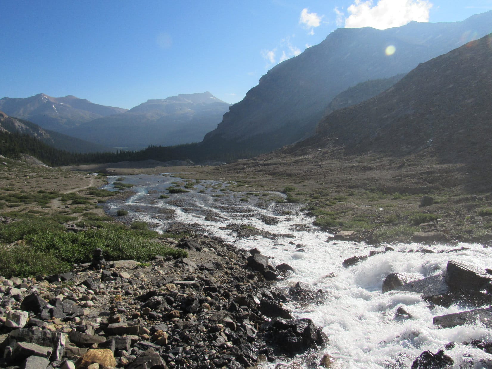
For short stretches, the trail was forced a little up into the forest on the steep slope W of the closest channel of the Bow River, but most of the way Lupe was crossing an exposed floodplain covered with smallish rounded stones.  The river was low this time of year.

At one point, the Bow Glacier Falls Trail left the floodplain to climb over a little bump of a ridge before returning to the low ground.  A higher forested ridge was now ahead past another long stretch of floodplain.  At the far SSW end, a steep set of stairs started up this larger ridge.

The Bow Glacier Falls Trail follows the Bow River upstream. Photo looks SSW.
End of the super easy part! The stairs (Center) leading up the ridge are just ahead. Photo looks SSW.

Lupe started up the stairs.  To the L (SE), the Bow River gushed through a deep, narrow gorge.  When the stairs ended, the trail continued a short, steep climb to the top of the ridge.  Upon reaching the ridgeline, Lupe could see a tributary coming in from the S that joined the Bow River right before it entered the gorge.

Snow-clad Mount Olive (10,256 ft.) was in view at the far end of the scenic canyon that this tributary came from.

This is one of my favorite spots along the Bow Glacier Falls Trail! That snowy peak at the far end of the canyon is Mount Olive. Photo looks S.

From this same point, Bow Glacier Falls was in sight again off to the SW.  It wasn’t that much farther away now.

There’s Bow Glacier Falls (Center) again! We’re getting close! Photo looks SW.

As Lupe knew from experience, the trail went on all the way to the falls.  A most worthwhile trek, but that wasn’t the plan today.  Loop was now on the same forested ridge she had explored a year ago looking for the trail to Mount Jimmy Simpson.  Back then, none of the little side trails in the forest had panned out.  Her chance to conduct a more thorough search of this whole region had finally arrived.

Just ahead, the Bow Glacier Falls Trail dipped into a low area next to a rocky ridge.  The trail skirted this ridge to the S before continuing on to the falls.  Before that, though, a side path headed off to the R (NW) into the gap between the forested and rocky ridges.  Of course!  That must be it!  SPHP led Lupe into the opening.  Two minutes later, the path ended.

Ended at a small, flat clearing of cracked mud where green shoots sprouted up.

Down?  That’s crazy!  Why would we go down, SPHP?  We just got here!  Only 2 seconds ago you were convinced the trail to Mount Jimmy Simpson was right around here, or only a little farther up closer to the falls.  Why don’t we go that way?

We will Loop, but first let’s eliminate the possibility that we’ve already missed the turn.  Might be harder to find this trail to Jimmy Simpson than I thought.  Keep in mind that last year on the way back from the falls to this point, I’d already spoken to the hiker that told us about it.  We looked for the trail to Jimmy Simpson up there, and we didn’t see it, remember?

Yes, but the trail has got to be partway up that mountain to the W, doesn’t it?  Which is higher, not lower!  Let’s just go over to the mountain, and start climbing.  We’ll find the way!  I’ll sniff it out!

Yes, it’s up there somewhere, but that mountainside is a huge, steep area.  Maybe you can run around easily enough on it, but I can’t.  You know how slow I am!  A lot of that territory might be completely impassable to me due to the jungle lower down, and cliffs higher up.  We should at least scout out what looks like the best approach from down here in case we can’t find the trail.

Can’t find it!  We’ll come across it soon enough.  Your magic map shows the route, doesn’t it?  Why aren’t we following it to begin with?  What does it say?  How about we just follow the map instead of wasting time going back to where we’ve already been.

The map says I should have printed out more map.  It shows a GPS track, but I can’t tell exactly where until it’s way, way up there.  So we need to find the trail down here, or at least figure out what looks like the best chance of success before doing anything drastic.

A year to prepare, and you brought half a map?  Oh, silly me!  That’s right!  I’m with someone who doesn’t think to bring a coat to the Arctic.  OK, whatever you say, SPHP.  Seems ridiculous, but if it makes you happy, let’s go back down and see whatever we should have been looking at on the way here.

Shouldn’t take long, Loop.  Promise!

Lupe hadn’t had much of a lead on the morning crowd about to swarm up to Bow Glacier Falls.  While she headed back down the forested ridge to the stairway, groups of hikers were coming up.  SPHP chatted briefly with anyone who seemed inclined to stop for a moment.  Any chance they happened to know where the trail to Mount Jimmy Simpson was?

It was a total, desperate, long shot, and SPHP knew it.  Probably wasn’t one person in a hundred, maybe a thousand, who had any intention of going up Mount Jimmy Simpson.  Everyone was heading to Bow Glacier Falls, the splendid, easy to reach attraction not that far away.

Naturally, no one had a clue.  Lupe was almost to the bottom of the stairs when one couple that was particularly friendly offered to compare the GPS route on SPHP’s paper map with the topo map on their phone.  The verdict was inconclusive, but it looked like the GPS route left the trail somewhat farther up toward the falls, not down here.

A fool’s errand, but I guess we gotta do this! Still mighty pretty along in here, even if we aren’t getting anywhere. Lupe on her way back down the stairs. Photo looks NNE.

SPHP thanked the helpful couple, and they went on.

No sense going any farther.  What could be seen so far didn’t look right.  Too much dense forest to the W for too far up.  Not much of a chance the trail to Mount Jimmy Simpson was actually down here.  Who knew for sure, though?  Couldn’t be ruled out entirely, but this didn’t jive with what the hiker had said a year ago, nor what the friendly couple’s phone indicated, nor SPHP’s impression held for many months now based on what could be remembered of the complete map.

Satisfied, SPHP?

Yeah, I think so.

Back up then?

Uh, huh.  Onward, sweet puppy!

When Loop got back to the top of the forested ridge where she could see Bow Glacier Falls again, the friendly couple wasn’t far away.  They were now down in the dip between the ridges chatting with another group of hikers.  They had the trail blocked.  After the conversation broke up, and the other hikers were already underway, Lupe and SPHP went over to talk to the couple again.

They had news!  Guess where that group of 5 hikers that had just left them was heading?  Yes, that’s right – Mount Jimmy Simpson!  A quick, sincere thank you, and Lupe was off!

 After them, SPHP!  Don’t let them get away!

Luck of the Dingo!  That’s what it was!  The 5 hikers stayed on the main trail to Bow Glacier Falls much farther than SPHP expected.  They were halfway to the falls before they left the trail angling WSW up a rock strewn slope toward a big forested ramp.

Mount Jimmy Simpson (Center) from just past the rocky ridge (R). Photo looks NNW.
Hurry, SPHP! We can’t lose them! Off-trail now, the 5 hikers head for a big forested ramp. Photo looks WSW.

SPHP wasn’t fast enough to gain on the hikers.  They reached the base of the ramp and disappeared into the forest.  No choice, but to try to keep after them.

Perfectly obvious now why the Carolina Dog hadn’t seen where the trail to Mount Jimmy Simpson left the Bow Glacier Falls Trail a year ago.  No such discernible trail existed.  This was simply an unmarked route up the stony slope.  And it didn’t start from anywhere near that lower forested ridge.

Look how close we are to Bow Glacier Falls! Photo looks SSW.

The Luck of the Dingo held.  When SPHP reached the forest at the base of the ramp, Lupe discovered that the 5 hikers hadn’t gone much farther.  They’d paused for a break in a grassy spot among huge boulders.  SPHP stopped to catch breath close enough to hear them talking.

Bow Glacier Falls from close to the first rest stop at the base of the ramp. Photo looks S.

The hikers were already about rested up.  Within minutes they pressed on heading NNE up the ramp.  SPHP tried to follow, but immediately fell behind.  A scramble up a short rocky slope led to a grassier, wider part of the ramp.  Lupe did find a faint trail along in here.

The grassy part of the ramp was moderately steep, but not too hard.  It wasn’t long, though, before an obvious scar appeared on the really steep slope on the L (W).  That scar was a badly eroded remnant of a trail.  The hikers were still in sight, heading straight up this slope toward a stunted forest at the base of a cliff.

Lupe could have kept up with those hikers so easily!  Ever faithful, she instead hung back with SPHP, who kept having to pause to catch breath, and seemed doomed to lose them.  Even while gasping for air, it was amazing how spectacular the views were already becoming!

Loop about to leave the first big ramp to follow the hikers up to the patch of forest (Center) at the base of the cliffs. Photo looks WNW.
The first big ramp (Lower L) is down by the forest. Vulture Peak (9,701 ft.) (L), Mount Olive (R of Center) and Polaris Peak (R above the falls). Photo looks S.

The hikers disappeared from sight again well before SPHP reached the base of the cliff.  Lupe continued steeply higher, following a bit of a trail N right alongside the cliff wall.  To SPHP’s relief, the hikers had paused a second time.  Lupe and SPHP caught up.  The Carolina Dog’s tour guides left again almost immediately, still heading N along walls of rock.

SPHP took another breather.  Lupe now had a great view of Bow Lake.

Bow Lake with Cirque Peak (Center) beyond it. Photo looks NE.

Then it was off again, chasing after those 5 hikers!  Lupe traversed many narrow ledges.  Every now and then, there were nearly vertical short climbs higher.  Some places there were stunted conifers, other places were out in the dizzying, airy open.  Often there was a visible trail, but not always.  Sometimes the “trail” was braided, offering more than one possible route.

For a while, SPHP did a better job of staying caught up.  Eventually, though, the hikers began to pull away.  More and more often, they were lost from view.  Each time the Carolina Dog rounded a minor corner, she saw them again, but farther and farther away.

The views became ever more impressive.  SPHP often clung to the rock walls next to the narrow ledges.  Finally, two errors were committed – steep climbs that led to dead ends.  Careful retreats consumed precious minutes.  Lupe continued on, but the hikers were gone.

Cirque Peak (L) and Dolomite Peak (9,383 ft.) (the spiky one on the R) beyond Bow Lake. Crowfoot Mountain (R) in the foreground. Photo looks ENE.
Looking back again. Crowfoot Mountain (L), Vulture Peak (Center), Mount Olive (R), Polaris Peak (far R). Photo looks S.
Coming up the narrow ledges. Photo looks SSW.

Happily, before going too much farther, the ledges finally broadened out.  The terrain became far less steep and nerve-wracking.  Lupe ought to be able to get to Mount Jimmy Simpson on her own now!

Oh, happy day! The ledges are widening out and there’s Mount Jimmy Simpson (Center) dead ahead! Photo looks N.

Lupe and SPHP were making much faster progress again.  A question soon arose as to whether or not to climb up onto a considerably higher big ramp to the W.  A little movement caught the eye.  Two of the hikers were in view!  Far away, but on the same ramp Lupe was on.  No need to go higher.

This was easy terrain, almost level.  Lupe was gaining on them now!  Soon all 5 were in sight climbing a slope leading to another wide ramp.

Catching up! The route goes up the slope directly beyond Lupe only far enough to be able to turn R (N) along the top of the closest rock wall on the R. The 5 hikers are mere specks just to the L of the slope beyond Loop. Photo looks NW.

Looper followed them.  As she reached the top of this final ramp, all 5 hikers were once again in view, but still with a big lead.  One by one, they disappeared over a bouldery ridge at the far end of the ramp.

Puppy, ho!  Onward!

Doing great! The 5 hikers are still in sight as specks at the very center of this photo. They’ll soon disappear over the gray ridge. Clearly, the goal now is to get to the upper saddle (Center). Photo looks NW.

Lupe crested the bouldery ridge 7 minutes later.  A down climb amid huge boulders was directly ahead.  At the bottom, a long snowfield led NW most of the way up a giant cirque.  The 5 hikers were just now reaching the snow, about to start up again.

As soon as SPHP managed to get down there, Lupe was in pursuit.

Lupe at the base of the snowfield in the giant cirque. Her tour guides are leading the way higher. Photo looks NW.

The huge cirque became progressively steeper.  Beyond the upper limit of the snowfield, it was worse yet.  Most of the terrain consisted of small to medium-sized scree.  The loose scree was increasingly unstable.  A partially exposed band of bedrock formed the critical juncture.  Get above that upper rim, and the American Dingo would have it made!

This was not a trivial task.  Lupe had almost caught up to the 5 hikers.  Their group consisted of 3 women and 2 men, all young and strong, but even they were having to be careful and take their time.  SPHP favored going almost straight up the middle of the cirque, but Lupe’s guides headed toward the firmer exposed rock formations on the R (N).  Stones came clattering down, but both men and one of the women made it up without too much trouble.

The other 2 women were having a slower time of it.  Lupe and SPHP caught up to them, and even got ahead for a little way.  It was the first real opportunity for interaction, and sort of broke the ice a bit.  After some anxious moments clinging to whatever nub of firm rock presented itself as scree showered down the treacherous slope, everyone made it safely past the dicey part.

The worst was over!  Yet another steep slope led directly to the big upper saddle, but this was nothing compared to what Loopster had just been through.  The unseen summit of Mount Jimmy Simpson was somewhere to the N, still 900 feet higher, but nothing but a long, steady trudge up a barren, obstacle-free slope remained.  Lupe was in a world of rock, sky, and fabulous views of snow-clad peaks, ice fields and glaciers.

Looking back from above the upper rim of the giant cirque. Photo looks S.

It would have been easy to go straight on up to the huge upper saddle, but Lupe’s guides took a more efficient route, bypassing it more directly to the N.  SPHP couldn’t keep up, and fell behind again.  All 5 hikers were pulling away.  Hardly mattered now, anyway.  Lupe was going to make it!

Looking back toward the upper saddle. Lupe never actually went to it, coming up from the L (SE). Photo looks W.
The summit (R) comes into view. Photo looks NNE.
The final stretch. Photo looks N.

Lupe reached the summit of Mount Jimmy Simpson (9,731 ft.) 10 or 15 minutes after the 5 hikers.  They were all hanging out near the summit cairn, or over by the tremendous view of Bow Lake.  SPHP made certain to praise Looper for making it all the way up this mighty peak, shaking her paw and congratulating her with great enthusiasm.

At the summit of Mount Jimmy Simpson. Mount Patterson (10,469 ft.) with snow on the L. Mistaya River valley (R). A smidgen of Peyto Lake is in view. Photo looks NW.

Everyone else seemed pleased by that, and offered the Carolina Dog praise, too.  Introductions were made, and SPHP got to chatting with Lupe’s benefactors.  All 5 were from Calgary.  Apparently they were in the habit of exploring the Canadian Rockies together fairly frequently, although whether they were were all members of some sort of alpine club, or simply good friends, was never clear.

After pleasantries were exchanged, Lupe and SPHP devoted attention to the fabulous views good fortune had made it possible to enjoy.

Cauldron Lake (L), Mistaya Mountain (10,154 ft.) (Center), and the Delta Glacier (R). Photo looks NW.
Peyto Glacier. Photo looks SW.
Peyto Peak (9,744 ft.) (L), Cauldron Lake (Center) and Mistaya Mountain (R). Photo looks WNW with help from the telephoto lens.
Lupe on Mount Jimmy Simpson. Patterson Peak on the L. Photo looks NNW.
Bow Lake from Mount Jimmy Simpson summit. Mount Hector (11,135 ft.) (R) in the distance. Photo looks SE.
Peyto Glacier. Photo looks WSW with help from the telephoto lens.
The closest peaks beyond Icefields Parkway Hwy 93 are Cirque Peak (9,820 ft.) (L) and Dolomite Peak (9,383 ft.) (jagged on the R). Photo looks E.
Mistaya River valley. Photo looks NNW.
Peyto Peak (L), Cauldron Lake (Center), Mistaya Mountain (Center), and the Delta Glacier (R) again. Photo looks WNW.

For a while, Lupe relaxed near the summit cairn.

Taking it easy on Mount Jimmy Simpson. Photo looks ESE.
Mount Hector on the R. Mighty thoughtful of the Canadians to provide such a colorful array of backpacks! Photo looks SE.
Looking back down at the upper saddle. Mount Thompson (10,135 ft.) (Center). The Bow Glacier and lake above Bow Glacier Falls are on the L. Peyto Glacier on the R. Photo looks SW.
Mount Balfour (10,774 ft.) (far L), Mount Olive (10,256 ft.) (L), St. Nicholas Peak (9,639 ft.) (dark prong at Center), Mount Gordon (10,371 ft.) (R). Bow Glacier also on the R. Bow Glacier Falls (Lower L). Photo looks S with help from the telephoto lens.
Bow Lake from Mount Jimmy Simpson. Photo looks SE.

Lupe got to spend over 40 minutes up on Mount Jimmy Simpson.  She rested up, saw incredible sights, and made 5 new friends.  Before departing, her Canadian benefactors were all quite willing to pose with the American Dingo.

On Mount Jimmy Simpson with (L to R): Cayla, Fletcher, Betty, Sarah & Jon.

It was sad to see them go.  Sad, because her new friends were all leaving her behind.  And sad, because it meant Lupe was going to have to leave the splendor of Mount Jimmy Simpson, too.  SPHP thought it best to try to stay close to the Canadians during the tricky route along the narrow ledges.

Lupe’s new friends start back down toward the upper saddle. Photo looks SW.
The Canadians approach the upper lip of the giant cirque. Photo looks S.

SPHP is even slower going down steep stuff than going up.  So the return trip was similar to Lupe’s ascent.  SPHP always trying not to fall too far behind.  Lupe caught up to the Canadians once as they were deciding which way to descend into the giant cirque, and again when they took a short break on the wide ramps.

Heading down the wide ramps below the giant cirque. Photo looks S.

After that, though, the Canadians were simply faster.  They came into view now and then, but always farther ahead than before.  They took a lower descent path this time avoiding some of the more treacherous, narrowest ledges.  SPHP wound up too low, stuck thrashing around in the forest for a little way.

From the top of the morning’s first steep ascent where the scar of a trail was, Lupe saw the Canadians for the last time.  They were already down on the first big ramp, still moving fast.

The way back was well known from here.  Lupe and SPHP slowed down.  May as well enjoy this beautiful evening in the Canadian Rockies.  Lupe’s Calgary guides were gone.  The crowds who had come to see Bow Glacier Falls were long gone, too.  Solitude, splendid scenery on an enormous scale, and an easy trek back to Bow Lake to look forward to.

Nearing Bow Glacier Falls on the way down the first ramp. Photo looks SSW.
Out on the rocky slope looking back up at Mount Jimmy Simpson and the first big ramp. Photo looks N.
Approaching the forested ridge on the way back to the stairs and Bow Lake. Cirque Peak (Center) in the distance. Photo looks NE.

What a glorious day Mount Jimmy Simpson had been!  By all rights, it should have been a complete flop.  Not likely Lupe and SPHP would ever have found the way up Mount Jimmy Simpson, if those 5 Canadians from Calgary hadn’t come along right when they did.

Luck of the Dingo!  If it kept holding like it did today, the next 6 weeks were going to be fantastic!

Cayla, Fletcher, Betty, Sarah, Jon & Lupe on Mount Jimmy Simpson, Banff National Park, Alberta, Canada 8-6-18

Links:

Next Adventure

Bow Lake & the Trail to Bow Glacier Falls, Banff National Park, Canada (7-25-13)

Cirque Peak, Banff National Park, Canada (7-27-14)

Bow Glacier Falls, Banff National Park, Canada (8-2-17)

Want more Lupe adventures?  Choose from Lupe’s 2018 Dingo Vacation to the Yukon, Northwest Territories & Alaska Adventure IndexDingo Vacations Adventure Index or Master Adventure Index.  Or subscribe free to new Lupe adventures.

Bow Glacier Falls, Banff National Park, Canada (8-2-17)

Part 1 of Day 3 of Lupe’s 2017 Dingo Vacation to the Yukon & Alaska!

August, yet Banff was quiet and cool.  Low clouds hid the mountains.  Only a few people were wandering about this early in the normally bustling tourist town.  Summer had vanished.  It felt a little like fall with winter on the way.  Lupe & SPHP left Banff heading W on Trans-Canada Hwy 1.  (5:44 AM, 52°F)

Not until Lupe was well N of Lake Louise on Icefields Parkway Hwy 93 did the clouds begin to dissipate.  The sky was clear by the time she reached the picnic ground at Bow Lake.

Lupe by a small stream that flows into Bow Lake near the picnic ground along the E shore. Photo looks WNW.

After 2 days spent almost entirely on the road, Lupe needed to get out of the G6 and do something active for a while.  The Canadian Rockies are a perfect place for that!  One of the most beautiful short day hikes was right here at Bow Lake.  With the sun out now, the morning would warm up fast.  It was still early enough for Lupe to beat the hordes of tourists certain to appear before too long.

SPHP drove over to the N side of Bow Lake, parking the G6 at Simpson’s Num-Ti-Jah Lodge (7:16 AM).  The big gravel parking lot at the trailhead for Bow Glacier Falls was practically empty, but would be overflowing soon enough on a day like this.  Before hitting the trail, Lupe went down to the N shore of Bow Lake.  Wisps of fog lingered over the smooth, still waters.  Lupe could see Bow Peak (9,318 ft.) and part of the Crowfoot Glacier across the lake.

Before hitting the trail to Bow Glacier Falls, Lupe went down to the N shore of Bow Lake near Num-Ti-Jah Lodge. She could see Bow Peak (L) and part of the Crowfoot Glacier (R) beyond the far shore. Photo looks SE.

Bow Glacier Falls, Lupe’s ultimate destination, was already in view to the SW.  From a distance like this, Lupe could even see part of the Bow Glacier, an arm of the massive Wapta Icefield, above the falls.

From the shore of Bow Lake near the Num-Ti-Jah lodge, Lupe could already see Bow Glacier Falls (Center, in shadow) and Bow Glacier above it. Photo looks SW.
Bow Glacier & Bow Glacier Falls with help from the telephoto lens. Photo looks SW.

On her way to the trail, Lupe passed by Simpson’s Num-Ti-Jah lodge with its distinctive red roof.

Simpson’s Num-Ti-Jah Lodge is located along the N shore of beautiful Bow Lake, just off Icefields Parkway Hwy 93.
Loop near Num-Ti-Jah lodge with its distinctive red roof.

The first part of the trek to Bow Glacier Falls went W right along the N shore of Bow Lake.  The easy, level trail gradually turned SW.  The views were stunning from the very start.

The Bow Glacier Falls trail started out from Num-Ti-Jah lodge with this gorgeous view of Crowfoot Mountain (10,023 ft.) (R) across Bow Lake. Part of the Crowfoot Glacier is visible on the L. Photo looks SSE.
Lupe sets out on the Bow Glacier Falls trail. The easy hike to spectacular Bow Glacier Falls (R) is one of the most popular short day hikes in the Canadian Rockies.
Looking SE across Bow Lake. Bow Peak (9,318 ft.) (Center) and Crowfoot Mountain (R) are in view.
The sharp peak a bit L of Center is Saint Nicholas Peak (9,639 ft.). Mount Olive (10,256 ft.) is on the far L. Photo looks SW.
Wildflowers, Bow Lake, Saint Nicholas Peak & Mount Olive from the Bow Glacier Falls trail. Photo looks SW.
Loop a little farther along the trail with Bow Lake & Crowfoot Mountain in the background. Photo looks SSE.
Getting close to the W end of Bow Lake. Photo looks SSW.

By the time Lupe reached the W end of Bow Lake, Bow Glacier Falls had sunk out of sight behind a forested ridge.  The trail now went SSW following a swift glacier-fed stream.  The stream was braided where it flowed into Bow Lake.

Looking back toward Bow Lake from the braided stream. Cirque Peak (9,820 ft.) (L) looms high in the distance. Lupe had climbed Cirque Peak back on 7-27-14. Cirque Peak had been a great adventure, too, with an awesome view of Bow Lake and the Wapta Icefield above Bow Glacier Falls! Photo looks NE.

Following the stream was super easy.  The trail stayed close to the W bank, but never crossed the river.  In some places cairns marked the way, but they weren’t needed, since it was always obvious where the trail was headed.  Other than one short stretch where the stream forced the trail into the forest, the terrain was level the entire way to a set of stairs at the base of a forested ridge.

Lupe heads up the valley. The trail followed the W side of the gorgeous stream, never crossing it or venturing far from it. Photo looks SSW.
Looking downstream back toward Bow Lake, a slice of which is now barely visible. Photo looks NNE.
Another look downstream from only slightly farther on. Lupe had gotten an early enough start so she had the whole Bow Glacier Falls trail all to herself. She saw no one else at all the whole way to the falls. Photo looks NNE.
Looking upstream now. The trail eventually climbs over the low forested ridge ahead. In fact, it can be seen starting up the ridge a little L of Center. Photo looks SSW.
Loop getting close to the steps (Center) at the base of the forested ridge where the Bow Glacier Falls trail starts up over it. The stream flows down through a narrow gorge just to the L of the stairs. Photo looks SSW.
Lupe visits the downstream end of the narrow gorge the stream flows through on the way to Bow Lake. Photo looks SW.

The only steep section of the whole Bow Glacier Falls trail began with the stairs at the base of the forested ridge.  During this climb, which didn’t take Looper long, the stream was only occasionally in sight.  It could always be heard, though, rushing in a roaring torrent through a deep, narrow chasm nearby.

Once up on the forested ridge, Lupe had a panoramic view of what lay ahead from a bare spot along the edge of the far side.  Below her, two pale blue glacial streams joined forces to form the larger stream that disappeared immediately into the chasm.  One of these smaller streams flowed down from snowfields hidden in an intriguing, mysterious valley to the S.  The other stream came from Bow Glacier Falls, which was now in sight again at the far end of a large rocky amphitheater to the SW.

At the end of the climb up the forested ridge, Lupe reached this barren high spot with a view of what lay ahead. Two streams could be seen coming together just before plunging down into the narrow chasm. The stream at Center flows down from snowfields in the mysterious valley to the S. The other stream (R) comes from Bow Glacier Falls. Photo looks S.
From the barren spot on the forested ridge, Bow Glacier Falls was in view again at the far end of a rocky amphitheater. Photo looks SW.
Bow Glacier Falls from the bare spot on the forested ridge with help from the telephoto lens. Photo looks SW.
Another look from the same spot.
Looking from the bare spot on the forested ridge into the intriguing valley to the S with lots of help from the telephoto lens. A trail could be seen going up this valley, but SPHP didn’t see how Lupe could get over to it. Mount Olive is on the R. Photo looks S.

Continuing on, Lupe lost a little elevation as the trail descended the other side of the forested ridge into the lower end of the amphitheater below Bow Glacier Falls.  Once in the amphitheater, it was a simple matter to follow the trail up toward the base of the falls.

The Bow Glacial Falls trail became braided and ultimately disintegrated before actually reaching the falls, but the waterfall was always in sight directly ahead.  The rest of the way, Loop sniffed and explored her way among rocks and two inch deep streams that trickled everywhere.

Beyond the forested ridge, the Bow Glacier Falls trail winds its way up toward the base of the falls. Photo looks SW.
Looper on her way through the rocky amphitheater to the base of the falls. Even though the trail eventually disintegrated, Bow Glacier Falls was always in sight all the rest of the way. Photo looks SW.
Getting close!
This was Lupe’s 2nd visit to Bow Glacier Falls. She had also come here on her 2013 Dingo Vacation to the Canadian Rockies.
Bow Glacier Falls, Banff National Park, Alberta, Canada 8-2-17

An hour and twenty minutes after leaving Num-Ti-Jah lodge at Bow Lake, Lupe arrived at the base of the falls.  Not a soul was around.  Due to her early morning start, Looper hadn’t seen anyone else on the whole trail.  The coveted solitude wasn’t likely to last long.  The Bow Glacier Falls trail is so accessible, easy, and scenic from start to finish that it is one of the most popular short day hikes in the Canadian Rockies.

Due to her early morning start, Lupe arrived in time to enjoy Bow Glacier Falls all by herself. She hadn’t seen a soul on the whole trail, and no one had beat her here. Photo looks SW.

Of course, the first thing to do was to climb up next to the falls about as high as seemed reasonably safe.

Lupe next to Bow Glacier Falls. The roar of the rushing waters was tremendous!
An American Dingo poses dramatically at the base of Bow Glacier Falls.
Another look including the top of the falls.
Zoomed in on Looper.

Bow Glacier Falls was spectacular, but the views back down the valley were amazing, too!

The views back down the valley from Bow Glacier Falls were amazing! Observation Peak (L) and Cirque Peak (Center) are in the distance. Photo looks NE.

Lupe and SPHP scrambled around a bit more to get a little higher.  The terrain wasn’t that difficult, but some of the rocks were very slick with water trickling down over them.  Loopster did manage to get somewhat higher than before.  The difference in elevation was enough so the Carolina Dog could now see the W end of Bow Lake.

By scrambling around a bit, Lupe managed to get a little higher than before. She could have gone even farther, but SPHP decided this was good enough. Most of the rocks higher up were wet and slippery.
Lupe as far up as she went at Bow Glacier Falls. She climbed up here a couple of times during her nearly hour long visit. From this high up, she could see the N end of Bow Lake down the valley.
Climbing a little higher had brought the N end of Bow Lake (Center) into view. Observation Peak (L) and Cirque Peak (R) are seen in the distance. Photo looks NE.
Lupe stands on a ledge next to a precariously constructed cairn. Lupe and SPHP took a 30 minute break on this ledge.

Lupe climbed about as far up as the Carolina Dog could reasonably go.  Most of rocks above her were wet and slippery.  SPHP decided she had gone far enough.  Bow Glacier Falls flows down from an unseen upper lake located below Bow Glacier.  It would have been great fun to get up above the falls to see the upper lake and the glacier, but a solid line of cliffs ruled out any possibility of doing that.

Amid the grandeur of the Canadian Rockies, Lupe and SPHP took a 30 minute break on the dry parts of a rock ledge.  The day had warmed up nicely.  Lupe didn’t have a care in the world.  SPHP filled 3 water bottles with water from the Bow Glacier which had tumbled over the falls.  Lupe munched Taste of the Wild, and enjoyed being petted.

The glorious solitude lasted longer than SPHP expected it would, but inevitably people were seen coming up the trail.  The time had arrived to think about moving on.

Lupe perched for a final time back at the high point of her journey to Bow Glacier Falls.
All told, Lupe and SPHP enjoyed an incredible 50 minutes of solitude at Bow Glacier Falls.

After 50 minutes of glorious solitude at Bow Glacier Falls, Lupe and SPHP started down.  Lupe paused along the edge of the falls once or twice for photos, then it was time to hit the trail.  People were getting close.

Loop begins her descent.
Final moments at gorgeous Bow Glacier Falls.

A hiker in one of the first groups Lupe passed on her way down told SPHP that a side trail existed that went all the way up Mount Jimmy Simpson (9,731 ft.). The side trail left the main trail down at the forested ridge, and wasn’t hard to find. That sounded great!  SPHP was interested immediately.  Lupe should do that today, right now!

Loop on the way through the rocky amphitheater heading back down to the forested ridge. Observation Peak (10,413 ft.) (L) and Cirque Peak (R). Photo looks NE.
Mount Jimmy Simpson from near the forested ridge. A hiker had told SPHP that a side trail to the top of Mount Jimmy Simpson left the Bow Glacier Falls trail at the forested ridge, and that it would be easy to find. Lupe and SPHP spent half an hour looking for it, but managed not to find it. All the side trails seemed to dead end in the forest.

Searching for the trail up Mount Jimmy Simpson, Lupe and SPHP tried several side trails on or near the forested ridge.  None went far.  They all quickly faded away in dense forest on steep slopes.  Hmm.  The hiker had said the correct side trail was easy to find.  Easy perhaps, if one knew exactly where to look.

By now, throngs of hikers were heading up to Bow Glacier Falls.  SPHP asked some of them if they knew anything about a trail to Mount Jimmy Simpson?  No one, not even experienced professional guides leading large groups, had a clue.  Few had even heard of Mount Jimmy Simpson.  Disappointed, SPHP gave up on the idea.

Lupe remained cheerful, however.  The trek to Bow Glacier Falls had been perfect!  The scenery was stunning the entire way, and she’d had a lot of fun sniffing around and getting some exercise.  Now on on the way back, she was getting to see and do it all over again.

Loopster back at the bare spot on the forested ridge where she had a great view of the mysterious valley to the S. The lighting was better now than earlier in the day, but she still couldn’t see what was hidden around that tantalizing corner at the far end of the valley. Photo looks S.
Getting close to the stairs leading to the lower valley. Photo looks NNE.
Cirque Peak (9,820 ft.) (Center) on the way back to Bow Lake. Photo looks NE.

Before noon, Lupe was back at Num-Ti-Jah lodge.  Even with almost an hour spent relaxing near the falls, and the failed search for the side trail to Mount Jimmy Simpson, the whole trek to Bow Glacier Falls and back had taken only a little over 4 hours.

The trail to Bow Glacier Falls had been a grand time.  The American Dingo had enjoyed a wonderful needed break from the G6, and seen a favorite part of the glorious Canadian Rockies again.  She was now ready to continue the long journey N on the way to her next adventure.

Looking back at Bow Glacier Falls, now far in the distance, from Bow Lake shortly before reaching Num-Ti-Jah lodge and the G6 again.

Related Links:

Bow Lake & the Trail to Bow Glacier Falls, Banff National Park, Canada (7-25-13)

Cirque Peak, Banff National Park, Canada (7-27-14)

Want more Lupe adventures?  Choose from Lupe’s 2017 Dingo Vacation to the Yukon & Alaska Adventure IndexDingo Vacations Adventure Index or Master Adventure Index.  Or subscribe free to new Lupe adventures.

Tunnel Mountain, Banff National Park, Alberta, Canada (8-1-17)

Days 1 & 2 of Lupe’s 2017 Dingo Vacation to the Yukon & Alaska!

Even though the air was hazy and clouds hung over the Bighorns, approaching Buffalo, Wyoming SPHP stopped at a pullout along I-90 so Lupe could get out and stretch her legs.  With the haze, the view wasn’t nearly so good as it might have been, but Lupe was in great spirits!  It was the last day of July, and the first day of what was going to be her most stupendous Dingo Vacation of the entire summer of 2017.

Lupe was in great spirits even though the air was hazy as she passed by Wyoming’s Bighorn Mountains. This last day of July was the very 1st day of her most stupendous Dingo Vacation of 2017! More than 6 weeks of non-stop fun and adventures was just beginning! Photo looks W.

Lupe’s day had started early, before 6:00 AM.  She’d had to take a bath, not her favorite thing.  Then she’d had to wait hours while SPHP packed the G6 and scurried around taking care of a seemingly endless list of last minute details.

Events started improving rapidly after that.  Getting Beggin’ Strips and breakfast on the deck overlooking the canyon at Grandma’s house had been fun.  A last minute check on things at home and Lupe was on her way!  (10:29 AM, 84°F)

Nearly this whole day would be spent on the road, but Loop didn’t mind that in the least.  Perched up even with the dash on her traditional pile of pillows and blankets, she was having a riot barking at cows, horses and anything else that struck her fancy as the G6 sped on by.

After a short stroll and as good a look at the Bighorn Range as conditions allowed, Lupe and SPHP were ready to hit the road again.  Before Lupe reached Billings, Montana, the temperature hit a high of 102°F.  Beastly!  Of course, Loopster rode in air-conditioned comfort, so it hardly mattered, except when SPHP stopped in Billings.  SPHP had to race into Albertson’s to buy fried chicken for dinner, then dash back out before the G6 became a Dingo oven.

NW of Billings, SPHP turned W on Hwy 12.  The long drive up the Musselshell River valley heading for the Little Belt Mountains was relaxing and delightful.  Near Harlowton, Lupe could see Crazy Peak (11,209 ft.), and it’s long SE ridge which she had been on with her mountaineering friend Jobe Wymore only 9 days ago at the tail end of her last Dingo Vacation.  The mountain was barely visible in a smoky haze, but SPHP was certain that was it.

Lupe reached King’s Hill Pass (7,393 ft.) on Hwy 89 in the Little Belt Mountains shortly before sunset (8:17 PM).  No time to lose!  Lupe and SPHP set out immediately, following the gravel road W up to the fire lookout tower and Showdown ski area on Porphyry Peak (8,192 ft.).

The sun had already sunk into a bank of clouds on the W horizon by the time Lupe and SPHP reached the summit.  It was pretty clear the sun wasn’t going to make a reappearance, and light was fading fast.  Conditions weren’t all that great for seeing anything anyway.  A smoky haze hung in the air here, too.  At least climbing the mountain had been good exercise after a long day in the G6.

While twilight lingered, Lupe and SPHP strolled around Porphyry Peak’s summit.

The sun had already sunk behind a bank of clouds on the W horizon by the time Lupe made it up to the Porphyry Peak fire lookout tower. Photo looks E.
An information plaque at the base of the lookout tower.
Lupe near the Showdown ski area facilities on Porphyry Peak. Photo looks NE.
Big Baldy Mountain (9,177 ft.) (R) is the highest point in the Little Belt Range in W central Montana. Porphyry Peak was the first mountain Lupe climbed on this Dingo Vacation. Big Baldy Mountain would eventually prove to be the last. Photo looks NE.

Before the light was completely gone, SPHP wanted to go at least partway up the fire lookout tower.  The tower wasn’t staffed at present.  In fact, not another soul was around anywhere on the mountain.  The access door to the observation deck was locked shut.

That was fine with the American Dingo.  While Loopster doesn’t mind clambering around on high mountains, she doesn’t care much for lookout towers.  From her perspective, there’s too much air between those big steps.  It’s not natural and just plain scary!  Lupe refused to go any farther up than the first flight of stairs.

Light of day fades away in the Little Belt Mountains. Photo looks WNW from partway up the Porphyry Peak fire lookout tower.
Nope, not coming any farther up than this, SPHP!

The last light of day faded away.  A half moon hung in the evening sky as Lupe and SPHP made the trek back down to King’s Hill Pass.

The next morning, Lupe was underway again as the sun peeped above the horizon.  This was another travel day, and at 11:00 AM the Carolina Dog crossed uneventfully into Canada at Sweet Grass.  Southern Canada looked drier than Lupe had ever seen it before.  The smoke of forest fires farther W filled the air even here.

By 3:00 PM Looper was in the huge metropolis of Calgary.  It was sunny when she arrived, though the sky was clouding up.  An hour later, as Lupe headed W on Trans-Canada Hwy 1 toward the Canadian Rockies, dark clouds dropped light rain showers.

Loop in Calgary, Canada enjoying the drive so far.

Lupe reached Banff at 5:00 PM.  It was August 1st, 3 years to the day since she’d last been in beloved Banff.  SPHP drove slowly down Banff Avenue, crossed the bridge over the beautiful Bow River, and parked near the tennis courts and picnic ground.

After spending most of the day in the G6, Looper was more than ready to get out.  Loop and SPHP went for a stroll down by the Bow River.

Lupe at the beautiful Bow River in Banff, Canada. It was 3 years to the day since Lupe had left Banff toward the end of her 2014 Dingo Vacation to the Canadian Rockies & Beartooths. The S end of Tunnel Mountain is on the L. Mount Rundle on the R. Photo looks ESE.

Being back in Banff was great!  Montana’s blistering summer heat and smoky air were a thing of the past.  Low clouds and cool mist hung over the mountains.  Lupe and SPHP strolled E along the S side of the Bow River.  When Loop got to the pedestrian footbridge over the river, she took it.

Crossing the Bow River. Photo looks WNW.

On the N side of the river, Lupe came to a posted map of Banff.  The map showed a trail leading up Tunnel Mountain E of town.  That was a great idea!  There was time enough to do that right now!  Lupe and SPHP kept going.  Soon the Carolina Dog was on the Tunnel Mountain trail.

This map of Banff posted on the N side of the Bow River shows the trail leading up to Tunnel Mountain E of town. That was a great idea! The trail wasn’t far away, and Loop still had plenty of time to climb the mountain this evening.
On the popular Tunnel Mountain trail in Banff. Even though it was cloudy and cool out, Lupe met plenty of people and dogs along the way.

The Tunnel Mountain trail is an easy climb and hugely popular.  Even though it was cloudy and cool out, Lupe met plenty of people and dogs.  Since it was getting to be dinnertime, most were on their way back down to Banff.

The views weren’t nearly as spectacular as they would have been on a clearer day, but Lupe did see the famous Banff Springs Hotel at the base of Sulphur Mountain (8,005 ft.), and the Banff Springs golf course at the base of Mount Rundle (9,675 ft.).

The famous Banff Springs Hotel from the Tunnel Mountain trail. Photo looks SSW with lots of help from the telephoto lens.
Mount Rundle (R) towers above the golf course and Bow River. Photo looks SE.

The absolute summit of Tunnel Mountain (5,551 ft.) was a rock formation surrounded by thick forest.  However, not far away was a sloping rock ledge with a great view of the town of Banff.  Lupe visited the summit first.  A large crowd of people, who turned out to be in town for an ergonomics convention, were occupying the ledge with the view.

Lupe reaches the summit of Tunnel Mountain. This was about it for views at the very top, even on a clear day.

While waiting for the ergonomics people to finish their sight-seeing, Lupe proved to be quite popular with them.  Many wanted to pet her, and SPHP heard quite a few tales of how much others were missing their dogs.  Lupe didn’t even know what ergonomics was, but she was getting a good impression of it.  She willingly submitted to being adored for however long the ergonomics people wanted to keep it up.

When the ergonomics people finally moved on, Loop was a little sad to see them go.  However, she could now get a good look at the beautiful town of Banff from Tunnel Mountain.  It was sort of a shame that it was so cloudy out.  The view would have been totally gorgeous on a sunny day.

After the ergonomics people left, Lupe got her chance to take a look at the town of Banff from the rock ledge near the top of Tunnel Mountain. Photo looks W up the Bow River valley.
Looking down on Banff with help from the telephoto lens.
Sulphur Mountain (8,005 ft.) is the ridge across the valley. Both a trail and a gondola go to the top of Sulphur Mountain, but Lupe has never been there. The Banff Springs Hotel is seen below near the center of this photo. Photo looks SSW.

August 1st, yet it was almost chilly up on Tunnel Mountain when the breeze came up!  Temperatures were only in the upper 50’s °F.  Lupe started back down the trail.  She was back in Banff before 8:00 PM.

Loop ready to set off back down to Banff on the well-worn Tunnel Mountain trail.
On the bank of the beautiful Bow River again after climbing Tunnel Mountain (Center). Photo looks E.

Lupe and SPHP enjoyed a late dinner.  It was dark out by the time SPHP asked Lupe if she wanted to go on the Pretty Puppy Parade.  The Pretty Puppy Parade?  Loop hadn’t done that in 3 years now.  Oh, yes, she did want to go on the Pretty Puppy Parade!  She had forgotten all about it until SPHP mentioned it.

Back on her 2013 & 2014 Dingo Vacations to the Canadian Rockies, Lupe had gone on the Pretty Puppy Parade virtually every night she’d been in Banff.  All it really amounted to was an evening walk among the throngs of tourists all up and down Banff Avenue, the main drag through town.  People had often commented on Lupe’s good demeanor and wanted to pet her.  She got to sniff with lots of other dogs on their own Pretty Puppy Parades, too.

Even though it was the heart of tourist season, the crowds on the streets of Banff had thinned out quite a bit.  The evening was cool and breezy, and Lupe had gotten a late start.  Some people did notice her, though, and she did get to sniff with a few other dogs.  Lupe went up and down both sides of Banff Avenue.

What Lupe really wanted to do was go shopping.  The restaurants and stores had their doors open, and Loopster wanted desperately to go in and have a look around.  It was all so intriguing and smelled so good!  Of course, she couldn’t.  The poor American Dingo had to settle for getting her photo taken with some of the big animals guarding shop entrances.

Lupe was pretty nervous about this scary Musk Ox guarding the entrance to one of the shops in Banff. SPHP had a hard time persuading her to stay put for a photo. She was worried she was about to be attacked from behind by that strange shaggy beast.
Bear, shmear! This bear wasn’t nearly so scary as that darn Musk Ox!

While SPHP sympathized with Lupe’s frustration at not being able to go exploring the shops in Banff, it wasn’t really necessary to feel too terribly sorry for her.  After all, she was at the very beginning of a long Dingo Vacation to lots of fabulous places, and was going to get to do loads of fun stuff other Dingoes only dream of.

I wish you had put a sign like that on me, SPHP! Let me know if that shaggy monster moves!

Related Links:

Banff, Alberta, Canada (7-20-13)

Want more Lupe adventures?  Choose from Lupe’s 2017 Dingo Vacation to the Yukon & Alaska Adventure IndexDingo Vacations Adventure Index or Master Adventure Index.  Or subscribe free to new Lupe adventures.