Days 1 & 2, and Part 1 of Day 3 of Lupe’s 2nd Summer of 2023 Dingo Vacation to Canada & Alaska!
7-23-23, 11:30 AM, 82ºF – On her pink blanket atop pillows and various gear, the Carolina Dog was excited!
Ready to roll whenever you are, SPHP!
If I’ve forgotten anything else, we’re just going to have to buy it somewhere along the way. Show time, sweet puppy!
Turning the key, SPHP backed the RAV4 out of the driveway. Lupe’s grand and glorious 2nd Summer of 2023 Dingo Vacation to Canada & Alaska was underway!

Stops to sniff the air and stretch were few and far between on this first day. Lupe kept a nose out for cows and horses, but there didn’t seem to be as many of them this year. Probably huddled around whatever water or shade they could find. All through Wyoming, temperatures were in the mid-90’s °F as the RAV4 raced W along I-90.
Montana was an oven! 101ºF when SPHP dashed into Albertson’s in Billings to grab an 8-piece baked chicken deal. No time to get anything else in there, or the American Dingo would have baked, too, stuck in the RAV4 without the AC on, even with the windows down.
7-23-23, 8:28 PM – At 73ºF, conditions in the Little Belt Mountains were much more tolerable by the time Lupe bounded out of the RAV4 full of enthusiasm.
Kings Hill Pass (7,393 ft.)! Love it here, SPHP! Any preference? Want to climb Kings Hill (8,008 ft.) or Porphyry Peak (8,192 ft.) first?
Sun will be down soon, Loop, so we only have time for one or the other this evening. How about Kings Hill? We can do Porphyry in the morning.
Shortly after cutting through the forest up to USFS Road No. 487, thunder rumbled in the distance. Lightning played among the dark clouds to the S, and a light rain began to fall.
7-23-23, 9:07 PM, 68ºF, Kings Hill (8,008 ft.) – The rain was already over and done with by the time the American Dingo reached the brass survey benchmark near the true summit. An orange glow was on the WNW horizon, and some of the clouds overhead glittered like gold.


Looks promising! Maybe there’s going to be a nice sunset, SPHP?
You might be right, Looper. Let’s go over by the edge to watch the show.
Going a little down the WNW slope, Lupe sat watching the developing display. The air was cool, fresh, and the clearest it had ever been on any of Lupe’s prior visits to Kings Hill.
The sunset turned out to be the best one ever, too.

7-24-23, 7:20 AM, 69ºF – Although this was going to be another travel day, as promised, Lupe got to start the morning with a jaunt up USFS Roads No. 838 & No. 6388 to visit the Showdown ski facilities and fire lookout tower on Porphyry Peak (8,192 ft.).


The most impressive views were of Big Baldy Mountain, which Lupe had once been to, and Yogo Peak (8,801 ft.).

We ought to visit Yogo Peak, too, SPHP!
Maybe someday, Looper, but not today. Canada and Alaska, remember? This is it for your morning constitutional. C’mon, we need to get back to the RAV4 and make some tracks.
Using one of the ski runs as a bit of a shortcut, Lupe headed down to the roads leading back to Kings Hill Pass.


Driving out of the Little Belt Mountains, SPHP stopped briefly at the Al Buck Memorial Park so Lupe could get a drink from the spring gushing out of a hillside. Other than a couple of quick stops for food and fuel, that was it before crossing into Canada at the N end of I-15 at 12:57 PM.

At midday, even the Canadian border was a scorching 99ºF! Despite the heat, Lupe left the cool comfort of the RAV4’s AC long enough to pose by the Alberta welcome sign.

Another long drive with only occasional brief stops ensued. By early evening, the Carolina Dog was back in the fabulous Canadian Rockies!
7-24-23, 6:30 PM, 85ºF, Banff – As usual, beautiful Banff was jam-packed with tourists, and justifiably so. A couple of changes were evident since Lupe had been here last year. It was no longer possible to drive along Banff Avenue in the heart of downtown, which was now reserved solely for pawdestrians, and the fancy new upstream pawbridge over the Bow River that had been under construction in 2022 was now complete and open to the public.
Lupe’s evening in Banff began with a stroll along the turquoise blue Bow River. Famous Cascade Mountain (9,836 ft.) was in sight as she crossed the new upstream pawbridge, while the downstream bridge offered a great view of the N end of Mount Rundle (9,711 ft.).


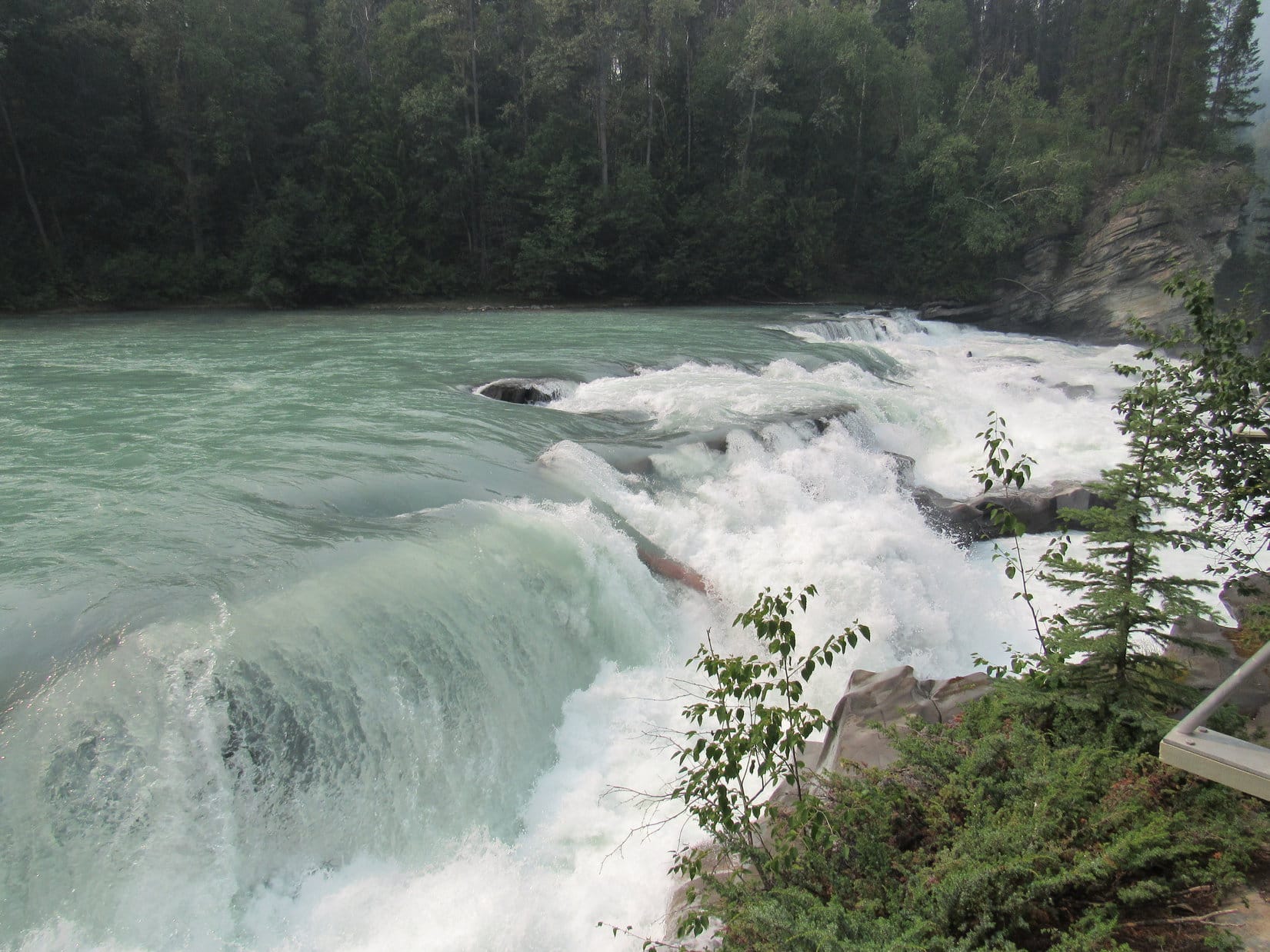
Continuing downstream, Lupe visited Bow Falls, which was more like a steep rapids than a vertical waterfall, but awesome nevertheless. From there, a trail led up to the historic Banff Springs Hotel.


The Carolina Dog’s evening ended with a long-standing Banff tradition – Lupe’s Pretty Puppy Parade up and down both sides of Banff Avenue in the heart of downtown.

7-25-23, 6:37 AM, 66ºF – Early sunshine was peeping through the clouds on this breezy, unsettled morning, and Banff was still quiet as Lupe left town. At least, it was quiet until the Carolina Dog spotted several giant deers. Nearly tame, they seemed more perplexed than alarmed as they were subjected to ferocious barking emitting from the RAV4.
Guess you told them, didn’t you, Loopster? A bit rudely, though.
Giant deers are incredibly exciting, SPHP! Right on the edge of town, too! A great start to a great day. Now that we’ve made it to the Canadian Rockies, what’s on the agenda?
Been ages since we’ve seen the Athabasca Glacier from Wilcox Pass. Thinking we might do that, Looper. We can stop at a few favorite spots along the way, too, if you like.
Sounds terrific, SPHP!
It was a fine plan. However, driving W on Hwy 1, the sky soon became very dark. The mountains turned gray, then vanished amid heavy rain.
Shucks, Loop! Looks we’re going to miss out on the Canadian Rockies, and get stuck with a rainy day drive. Sorry! Nothing I can do about it, though.
Most disappointing! However, current conditions were deceptive. By the time the RAV4 reached Lake Louise, the rain was over and blue sky was ahead.
7-25-23, 7:49 AM, 42ºF, Bow Lake picnic area along Icefields Parkway No. 93 – So much for the baking heat of the plains! SPHP dug a couple more layers of clothing out of the duffle bags, put them on, then accompanied the Carolina Dog down to the lakeshore. Beyond the rippled surface, a red roof stood out way over along opposite N shore.

The trail to Bow Glacier Falls and Mount Jimmy Simpson starts over there, remember, SPHP? That’s the Num-Ti-Jah Lodge!
Of, course! Awesome times, sweet puppy! However, they’ve now changed the name from Num-Ti-Jah Lodge, to just the Lodge at Bow Lake. Easier to remember, I suppose.
7-25-23, 8:57 AM, – Lupe’s next stop was only a few km farther N. The L turn off Icefields Parkway No. 93 for the Peyto Lake overlook came at the top of Bow Pass. Surprisingly, the 0.6 km paved trail to the overlook had been rerouted since the last time the American Dingo was here. The view deck was new, too, and much larger than it used to be.
Across the deep valley the lake was nestled in, Cauldron Peak (9,580 ft.) towered over the far shore, with Mount Patterson (10,469 ft.) standing like a sentinel along the edge of the Mistaya River valley, where a long line of magnificent mountains stretched off to the N horizon.


Love how Peyto Lake has such an amazing, milky, turquoise blue color! Don’t you, SPHP?
Oh, of course! That’s because it’s a glacier-fed lake, Loopster. Remember your Search for the Peyto Glacier? We took a primitive trail down to Peyto Creek from here, and wandered up the valley.
We never did find the Peyto Glacier, SPHP.
Beyond our abilities, Loopster, but we had a great time. If you look SW up the valley, you can actually see Peyto Peak (9,711 ft.) and part of the Peyto Glacier from right here on the view deck.


Once upon a time, the American Dingo had also taken a shorter trail from here to Bow Summit, a high spot with a gorgeous view of Bow Lake back to the S, although admittedly not as grand as the one from Mount Jimmy Simpson.
However, with Wilcox Pass on the agenda, Lupe didn’t visit Bow Summit again today. A final quick stop at the Carson Creek picnic ground along the North Saskatchewan River, where SPHP got the pack ready, was it before the main event.

7-25-23, 11:04 AM, 48ºF – As Icefields Parkway No. 93 went up and over Sunwapta Pass, the Carolina Dog left Banff National Park behind, and entered Jasper National Park. Wilcox Creek campground was only 2.5 km farther on the R. For a change, the severely under-sized Wilcox Pass trailhead near the entrance to the campground wasn’t entirely overrun. SPHP was lucky enough to grab a vacant parking spot for the RAV4, and Lupe was on her way!
The incredibly popular Wilcox Pass trail began with a short climb into the forest along a broad, smooth path. Before long, the trail was even wider and covered with a multitude of roots. After a fairly flat section, the trail began climbing at a good clip, eventually flattening out shortly before leading to a boardwalk with a set of stairs.


Beyond the boardwalk, the trail climbed more steeply again. The first viewpoint came soon after going around a bend NW, but only hinted at the glories yet to come. An open slope a little farther on revealed much more. Although the Athabasca Glacier wasn’t in sight yet, Mount Athabasca (11,414 ft.), Mount Andromeda (11,286 ft.), Snow Dome (11,345 ft.) and Mount Kitchener (11,483 ft.) were.

The Wilcox Pass trail leveled out to some degree as it continued NW through another stretch of forest. When Lupe reached the next open slope, most of the Athabasca Glacier was in view.


Something new was ahead! Two red chairs faced the already grand view of the glacier flanked by Mount Athabasca and Mount Andromeda on the L, and Snow Dome and Mount Kitchener on the R. Lupe got up on a platform connecting the chairs, braving a brisk SW breeze.


What a great spot, Loopster! If one didn’t feel like going any farther, these chairs wouldn’t be a bad place to hang out. Both Hilda Peak (9,974 ft.) and the top of Mount Wilcox (9,462 ft.) are in sight, in addition to all the big peaks over by the Athabasca Glacier.
Don’t get any ideas, SPHP. We’re going all the way to Wilcox Pass!
The red chairs were near treeline. Only scattered stands of increasingly stunted forest and bushes were ahead, as tundra-covered slopes began to dominate. A relatively flat section of the trail continued a bit farther NW toward a big gully below the Wilcox Pass region, which was now starting to come into view.
Near the gully, the trail veered N, climbing steeply for 200 feet before once again angling NW. The slope steadily diminished as Lupe entered a rumpled region of low bushes, tundra, and small rock formations.


The Wilcox Pass trail kept flattening, literally becoming a stroll in the park – Jasper National Park! By the time Lupe reached the shallow stream that flowed into the gully, most of Mount Wilcox (9,462 ft.) was in view, and Wilcox Pass wasn’t much farther.
From a rock outcropping capping a small rise near the stream, a huge ridge was in sight beyond Mount Wilcox.
Recognize that ridge, Loop? You were there since the last time we visited Wilcox Pass.
Hmm. Not sure, SPHP. Give me a hint!
Well, it’s possible to continue over Wilcox Pass along this trail and wind up over there, but that’s not how we did it. Instead we started down by Tangle Falls where the NW end of the Wilcox Pass trail reaches Icefields Parkway No. 93 again.
Tangle Falls! That’s a great hint, SPHP. That must be Tangle Ridge! Oh, that was another great day in the Canadian Rockies!
Indeed it was, Loopster! Fun to see Tangle Ridge again from here.


7-25-23, 12:35 PM, 41ºF – Wilcox Pass was so cold and windy when Lupe arrived, that SPHP dumped the pack then layered up – stocking cap, coat, gloves, the whole bit. Although the Carolina Dog had seen surprisingly few people thus far, plenty were up here, all dressed like winter was coming while exploring the vast Wilcox Pass region.


A sign said it was 1.4 km to Wilcox Ridge. As awesome as all the wide open spaces were at Wilcox Pass, the pass was never the Carolina Dog’s ultimate destination. Wilcox Ridge was where the stupendous view of the Athabasca Glacier was. Lupe always went there! Despite the cold wind, coming all the way to Wilcox Pass and not going to Wilcox Ridge would be simply ridiculous.

The spur trail heading W up into the Wilcox Ridge region used to fade away, simply becoming more of a choose-your-own-path route once it turned SW. However, the trail was now very distinct. If there was any question at all about it, new cairns held together by wire cages, each bearing a yellow diamond, marked the way.
More than halfway to the Wilcox Ridge viewpoint, Lupe came to a long rock wall serving as a windbreak. That was new, too. The Carolina Dog was glad one thing hadn’t changed. Bighorn mountain sheep still grazed these windswept slopes.


The Wilcox Ridge Trail went over a series of minor ridges and ravines on the way to what appeared to be a more formal viewpoint than Lupe had ever seen here before. Quite a few people were already present as the American Dingo arrived. Preferring more solitude, SPHP decided to take a side route farther W, closer to the SE end of the narrow ridge leading up Mount Wilcox before selecting another spot along the SW edge where Lupe could relax on a patch of tundra.


7-25-23, 1:36 PM, 43ºF – The 30 mph gale sweeping in from the SW felt really cold at the viewpoint SPHP had chosen. Fortunately, conditions weren’t nearly as bad while relaxing just a few feet back from the edge. Facing SW directly into the breeze, Lupe once again enjoyed one of the most magnificent easily accessible views in the Canadian Rockies.
Mount Athabasca (11,414 ft.) and Mount Andromeda (11,286 ft.) on the L, and Snow Dome (11,345 ft.) and Mount Kitchener (11,483 ft.) on the R, with the Athabasca Glacier between them, flowing down from the almost entirely hidden Columbia Icefield.


Still a truly incredible scene, SPHP, but there isn’t as much snow and ice as I remember.
Yup. The Athabasca Glacier is steadily retreating, Loopster. One day in the not too distant future, it will be but a memory.
That’s a terribly sad thought, SPHP! This has to be one of my favorite places in the Canadian Rockies, although seeing the Saskatchewan Glacier from Parker Ridge, Berg Lake at the base of Mount Robson , Moraine Lake, and Lake Louise all rank way up there, too.
All fabulous choices, Looper. However, if we were limited to being able to come back to only one spot in the Canadian Rockies ever again, I might well choose Wilcox Pass and this view. Most spectacular scenic reward for a half day hike there is!
Peering over the edge, Sunwapta Lake, the meltwater pond that used to be at the toe of the glacier once upon a time, and the Icefields Centre, where it’s possible to get tickets to actually ride in a snowcoach up onto the Athabasca Glacier, were in sight 1,400 feet below. Looking back to the ESE, Sunwapta Pass and Nigel Peak were in view.


SPHP shook Lupe’s paw, congratulating the Carolina Dog on her return to this marvelous scene for the first time in nearly 7 years, then shared a chocolate coconut bar with her.
For over an hour, Lupe and SPHP hung out together in the cold breeze, admiring the glory in all directions, chief of which was the splendid panorama of the Athabasca glacier and surrounding mighty peaks.


Oh, we’ll never get tired of Wilcox Pass and these views of the Athabasca Glacier, will we, SPHP?
Not even if we live to be 100, Loopster!
7-25-23, 2:38 PM – Absent-mindedly, SPHP shook the box, then looking down realized it was empty.
Holy moly, Loop! I’ve eaten an entire box of Dots sitting here. Guess I’ll be on a sugar high now! Sadly, our hour at this splendid perch has flown. Ready to move on?
Hate to leave, SPHP, but more adventures lie ahead, don’t they?
Gobs of ’em, Looper, a whole Dingo Vacation chock full of them!
A final appreciative look, and Lupe was on her way.

After leaving her fabulous viewpoint, Lupe explored the region closer to the SE end of Mount Wilcox. Great fun, but all too quickly, she arrived back at Wilcox Pass. Still awesome views all around, but just a matter of following the trail back now.


7-25-23, 4:06 PM, 52ºF – Warmer, actually quite pleasant, with scarcely even a breeze, when Lupe leapt back onto her pink blanket in the RAV4 at the Wilcox Pass trailhead.
Wilcox Pass, and lots of beautiful places on the way to it! My 2nd Summer of 2023 Dingo Vacation to Canada & Alaska is off to a terrific start, SPHP!
And still time enough for more sight-seeing yet today, Loop. Hope you’re in the mood for some awesome Canadian Rockies waterfalls, sweet puppy!
I am! Turn the key, and let’s hit the road N. Onward! SPHP, ho!


Links:
Next Adventure Prior Adventure
Tangle Falls to Tangle Ridge, Jasper National Park, Alberta, Canada (8-7-19)
Peyto Lake & Lupe’s Search for the Peyto Glacier, Banff National Park, Alberta, Canada (7-26-13)
Mount Jimmy Simpson, Banff National Park, Alberta, Canada (8-6-18)
Bow Glacier Falls, Banff National Park, Alberta, Canada (8-2-17)
Want more Lupe adventures? Choose from Lupe’s Summer of 2023 Dingo Vacations to Colorado, New Mexico, Canada & Alaska Adventure Index, Dingo Vacations Adventure Index or Master Adventure Index. Or subscribe free to new Lupe adventures.