Hazelton Pyramid, Bighorn Mountains, Wyoming (7-18-16)

It wasn’t even noon yet, when Lupe concluded her successful visit to all three possible Washakie County, Wyoming high points (9,600 ft.).  There was still time in the day for Lupe to tackle her next peakbagging goal, Hazelton Pyramid (10,534 ft.), which was only 6 or 7 miles away to the SE.  Lupe and SPHP headed E on Hwy 16 in the G6.  After going just a couple of miles, SPHP parked at Powder River Pass.

Some sort of bicycling event was going on along Hwy 16.  There were lots of bicyclists at the big pullout, which was serving as a rest and refreshment stop.

Lupe near Powder River Pass. Photo looks NNE.

Lupe wasn’t here for the bicycle event.  A short stroll S of Hwy 16 were some big rock formations from which SPHP wanted to get a preliminary look at Hazelton Pyramid.

Lupe up on the rock formations near Powder River Pass. Hazelton Pyramid is the more distant peak on the R. Photo looks SSE.
Hesse Mountain (10,385 ft.) (L) as seen from Powder River Pass. Nearly 2 years ago, Lupe had climbed Hesse Mountain on 8-6-14. Photo looks SE.
Hesse Mountain (10,385 ft.) (L) could also be seen from Powder River Pass. Nearly 2 years ago, Lupe had climbed Hesse Mountain on 8-6-14. Photo looks SE.

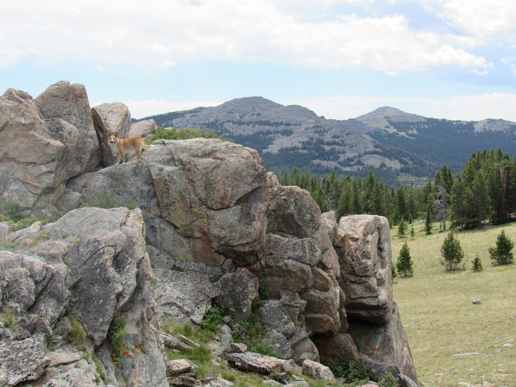
The view of Hazelton Pyramid was encouraging.  Lupe also got a look at Hesse Mountain, which she had climbed on an intermittently foggy day almost 2 years ago.

Lupe and SPHP returned to the G6.  A mile E of Powder River Pass, SPHP turned S off Hwy 16 onto USFS Road No. 29.  No. 29 wound around for 4 or 5 miles in a generally SSW direction.  At a small turnaround loop where the road first reaches the North Fork of the Powder River, SPHP parked the G6 again (1:02 PM).  Hazelton Pyramid was about 2 miles away to the ESE.  Lupe would start for Hazelton Pyramid from here.

Hazelton Pyramid is the more distant peak on the R. The high ground at Center is in the area of High Point 10201 on the Peakbagger.com topo map. Photo taken from USFS Road No. 29 before reaching the North Fork of the Powder River. Photo looks SE.
Lupe cools off in the North Fork of the Powder River before setting out for Hazelton Pyramid.

A bridge near the turnaround loop got SPHP over to the N side of the Powder River where Lupe started off heading NE on 4WD Route 584111.  She soon turned E on Route 584116, which quickly leveled out and left open ground to enter the forest.  Before long, the road curved S and crossed a small creek.  Beyond the creek, Lupe and SPHP continued on the road, but not very far, since it started trending SW.

Lupe left the road to begin climbing ESE through the forest.  The forest featured great views of, well, trees.  Lupe was happy with that.  Trees meant squirrels!  The slope gained elevation at a moderate pace, making for a pretty pleasant shady trek.  Lupe had fun dashing this way and that winding along a maze of faint animal trails.  She did find a few squirrels to growl and bark at, while they taunted and hurled insults at her from the safety of the treetops.

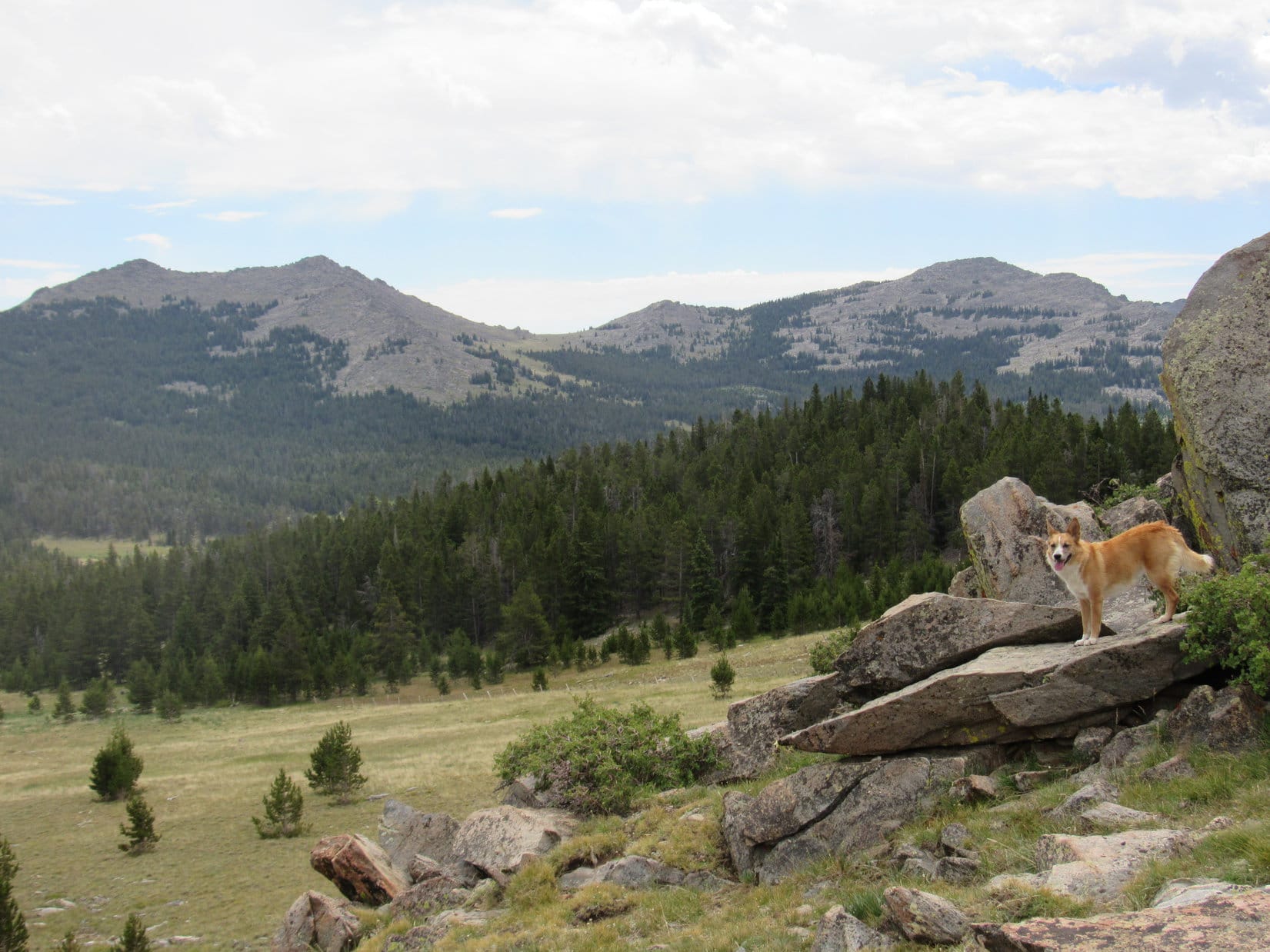
After 0.5 mile or more going through the forest, Lupe reached the top of a relatively flat and broad ridge.  There was a large meadow here from which it was possible to see Hazelton Pyramid again, and some of the high ground above tree line leading to it.

Lupe reaches a big meadow on the first ridge. Hazelton Pyramid is the distant peak on the R. From here, Lupe headed toward the high rocky ridge on the L. She followed the base of that ridge to the minor pass and high point seen just L of Center. Photo looks E.

There were a couple of reasonable looking routes toward Hazelton Pyramid from here.  Lupe could either climb above tree line heading ENE to the base of a rocky ridge which she could follow up to high ground near High Point 10201, or stay lower and farther S while heading E in an area of scattered forest.

SPHP thought the route up near the rocky ridge looked more dramatic and interesting.  Lupe was quite certain the scattered forest would offer more squirrel possibilities, but she had no real objections to the rocky route.  After all, there might be marmots up there, and marmots are fun, too!  Either way was fine with Lupe.  In any case, there was still a bit of forest to go through even to get to the rocky route.

Above tree line, Lupe approaches the rocky ridge (L). She soon passed below it to reach the saddle seen R of Center, and then climbed the high point on the R. Photo looks E.

Lupe lost a little elevation going through the last section of forest on the way to the rocky route, but quickly regained it on a somewhat steep climb just beyond the forest.  Soon (well relatively soon, SPHP kept stopping for air) Lupe was approaching the area below the rocky ridge.  Here the climb was not so steep. The views got better and better as Lupe headed for a saddle near the E end of the ridge.

Looking back to the W along the rocky ridge as Lupe continues her climb.

When Lupe reached the saddle (a short distance SW of High Point 10201), she had a great view of Hazelton Pyramid ahead.  Lupe could also see the high ground she would follow as it swept around to the summit.

Lupe reaches the saddle SW of High Point 10201. Hazelton Pyramid is seen beyond her. Lupe would eventually follow the high ground on the L as it sweeps around toward the summit. Photo looks ESE.

Before continuing on to Hazelton Pyramid, Lupe checked out the views from the minor high point immediately SW of the saddle.

Lupe up on the minor high point SW of the saddle. Photo looks SW.
Looking NW over the rocky ridge toward some of the higher peaks of the Bighorns.
Looking W. USFS Road No. 29 is visible far below on the L. The G6 is parked down there, but not in view.

After a short rest break on the minor high point, Lupe and SPHP returned to the saddle.  It was time to follow the high ground leading over to the summit of Hazelton Pyramid.  Most of the time, Lupe was able to stay at or near the top of the long ridge.  A couple of times she was forced to lose some elevation to get around small cliffs.

Getting closer! Photo looks SE.
Looking back to the W along Lupe's route. This first part of the way from the minor high point was pretty easy. The high ground was wide, mostly grassy, and not steep at all. As Lupe got closer to the top of Hazelton Pyramid, the ground grew progressively rougher, rockier, and steeper.
Looking back to the W along Lupe’s route. This first part of the way from the minor high point was pretty easy. The high ground was wide, mostly grassy, and not steep at all. As Lupe got closer to the top of Hazelton Pyramid, the ground grew progressively rougher, rockier, and steeper.

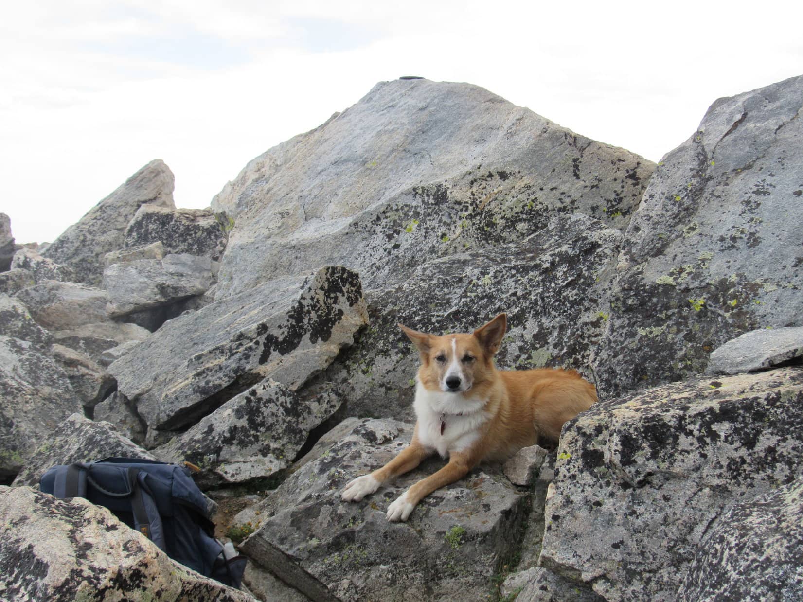
The last part of Lupe’s climb up Hazelton Pyramid was the steepest and rockiest, but still easily manageable.  The true summit turned out to be along a ridge of boulders extending farther to the SE a few hundred feet beyond the apparent summit Lupe had seen while climbing up from the NW.  Lupe and SPHP stayed on the NE side of this ridge due to a steep drop off immediately to the SW.

On Hazelton Pyramid! The very highest boulder is seen still a little farther beyond Lupe. Photo looks SE.
Lupe reaches the highest boulder on Hazelton Pyramid! Photo looks SE.
Lupe at the summit. Note the survey benchmark clearly visible on top of the boulder. Photo looks SE.
The survey benchmark at the summit.

Naturally, Lupe and SPHP took a break up on Hazelton Pyramid for water, a bit to eat, and to spend some time admiring the splendid views.  Although it had been a beautiful, mostly sunny day during the entire ascent, a line of gray clouds was now approaching from the SW.  Streaks of rain trailed beneath the clouds.  SPHP eyed the clouds suspiciously, even though they didn’t look too threatening.

Fortunately, there wasn’t any thunder or lightning.  Lupe and SPHP stayed on the mountain.  A SW wind picked up and blew rather strongly for a little while as the clouds approached.  Lupe had to endure a rainstorm as they passed over Hazelton Pyramid, but it didn’t rain hard or last too long.  The day soon grew somewhat sunnier again.

Looking NNW from Hazelton Peak before the rain clouds arrived. The cairn seen next to Lupe is some distance NW of the true summit. Lupe originally passed by it on her way to the summit. High Point 10372 is the barren, somewhat lower peak 1.25 miles away in the foreground R of Center. Much higher peaks of the Bighorn range are seen on the far horizon.
Lupe went a little farther SE along the summit ridgeline beyond the true summit of Hazelton Pyramid (10,534 ft.) to get this view of Hazelton Peak (10,264 ft.) seen beyond Lupe another 1.33 miles farther to the SE.
Lupe went a little farther SE past the true summit of Hazelton Pyramid (10,534 ft.) to get this view of Hazelton Peak (10,264 ft.), seen beyond Lupe another 1.33 miles farther to the SE.
Looking WSW over the edge of the Hazelton Pyramid summit ridge.
Lupe in an Egyptian mood just below the summit of Hazelton Pyramid. Here she poses as the Dingo-Sphinx. SPHP did not dare request any riddle from the Dingo-Sphinx for fear of what might happen if SPHP couldn't answer the riddle correctly.
Lupe in an Egyptian mood just below the summit of Hazelton Pyramid. Here she poses as the Dingo-Sphinx. SPHP did not dare request any riddle from the Dingo-Sphinx for fear of what might happen if SPHP couldn’t answer the riddle correctly.

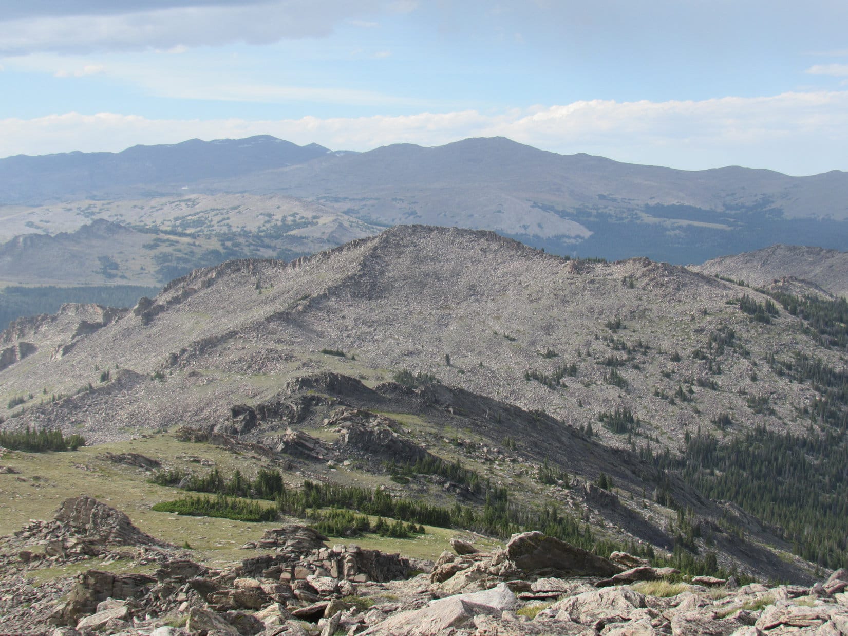
Eventually, of course, it was time to start down off Hazelton Peak to begin the trek back to the G6.  For a long way, Lupe and SPHP continued to enjoy the wonderful mountain scenery visible from the high ground above tree line.

Lupe starts back down off Hazelton Pyramid. She would retrace her route up along the high ground seen on the long ridge in the foreground, going first down toward the R, and then over to the L. Photo looks W.
Tiny blue flowers like these were abundant on the upper slopes of Hazelton Pyramid.
Looking NNW. High Point 10372 in the foreground on the R.
Looking W toward the minor high point (L of Center) Lupe climbed on the way to Hazelton Pyramid. The saddle is seen to the R of it. Somewhere in the cluster of rocky prominences to the R of center is High Point 10201.
High Point 10372 with higher peaks of the Bighorn Range in the distance. Photo looks NNW using the telephoto lens.
Looking back up at the apparent summit of Hazelton Pyramid from the NW. The true summit is out of sight 200 to 300 feet farther SE along a continuation of the ridge of boulders seen on the R which curves directly away from the camera at a point near the Center of this photo.
Looking back up at the apparent summit of Hazelton Pyramid from the NW. The true summit is out of sight 200 to 300 feet farther SE along a continuation of the ridge of boulders seen on the R, which curves directly away from the camera at a point near the Center of this photo.
Looking N. High Point 10372 (L) and double-peaked Hesse Mountain (R) with higher peaks of the Bighorn Range on the horizon.
Rock columns in the general area of High Point 10201. Photo looks N.
Lupe returns to the saddle area NE of the minor high point she climbed on the way to Hazelton Pyramid. Photo looks N.
Looking W back down along the first rocky ridge.

Lupe retraced her way up Hazelton Peak all the way back down below tree line.  Not too long after reaching the forest, SPHP tried to take a shortcut, heading WNW down off the ridge before reaching the big meadow.

The shortcut became a longcut and a Lupe adventure all its own, but one without photos as SPHP tried to hurry through the darkening forest.  At one point Lupe crossed a road which may have been 4WD Route 584113.  Lupe explored beautiful little clearings of swampy land near a tiny creek.  However, the forest seemed longer, denser, and more difficult to navigate than on Lupe’s original route.

All’s well that ends well, though!  Lupe finally emerged from the forest and swamps on open ground above and N of 4WD Route 584116.  SPHP recognized Route 584111 a little farther off to the W.  Lupe trotted happily along.  She was almost back to the North Fork of the Powder River and the G6 (7:37 PM).

Sunset in the Bighorn Mountains, 7-18-16

Well, Loopster!  That was a pretty good day wasn’t it?  Up before dawn barking at cows and horses on the way to the Bighorns, visiting all 3 of the Washakie County High Point candidates, and then climbing Hazelton Pyramid, too!

Yes, this was great, and about time, too!  What’s on the agenda tomorrow?

Tomorrow you start for Cloud Peak (13,167 ft.), the highest mountain in the entire Bighorn Range!  It’s so big and so far it will take us 2 days to get to the top.

Oh, sounds exciting!  Will there be squirrels?

I think you’re gonna like it, and yeah, there should be some squirrels.  Believe me, your summer of 2016 is going to be fantastic.  You haven’t seen anything yet, Looper!

Heh, I certainly hope so SPHP, until today that’s been just about literally true! 

Links:

Next Adventure                        Prior Adventure

Hazelton Peak, Bighorn Mountains, Wyoming 6-27-19

Want more Lupe adventures?  Choose from Lupe’s 2016 Bighorn Mountains, WY Adventure IndexDingo Vacations Adventure Index or Master Adventure Index.  Or subscribe free to new Lupe adventures.