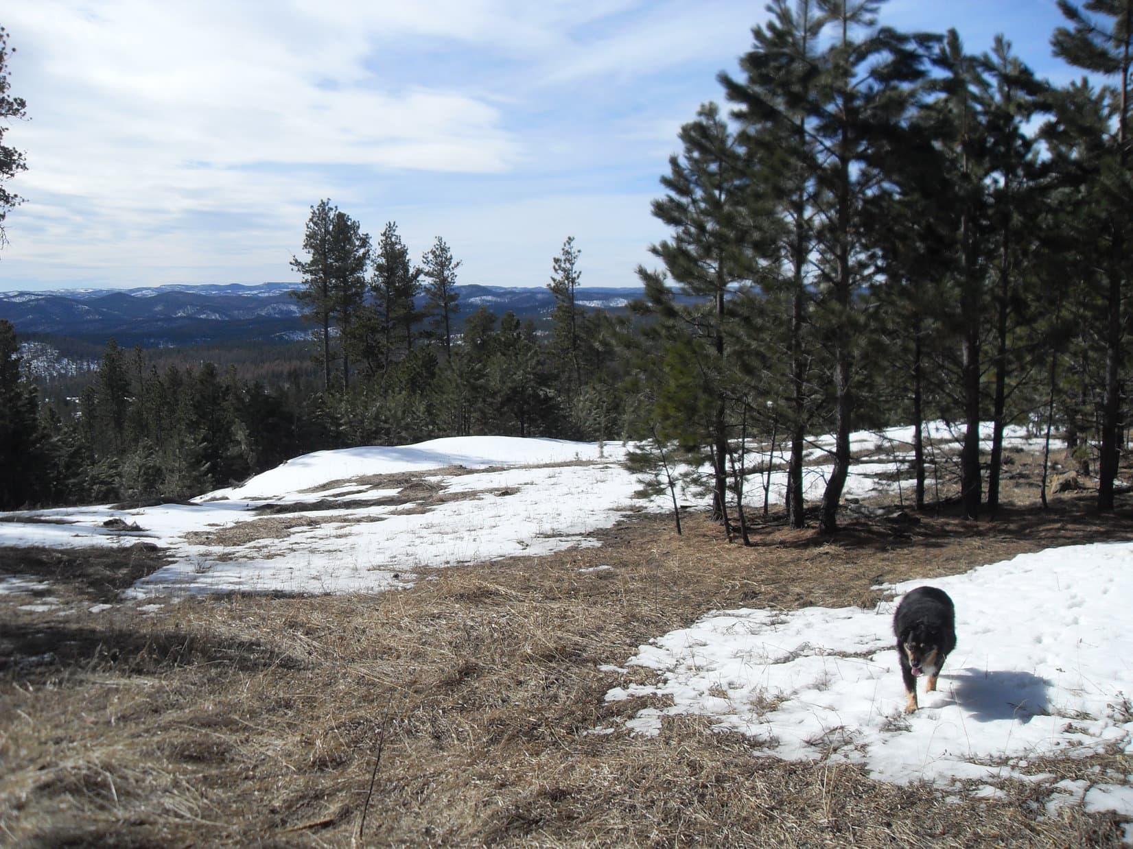
11:30 AM, start of USFS Road No. 203 off Rochford Road – What? Totally unexpected! A crew was doing some kind of maintenance work on USFS Road No. 203, the very road SPHP had chosen for today’s expedition in light of Cousin Dusty’s need for a relatively easy experience.
At the start of USFS Road No. 203 with unexpected road work ahead. Photo looks NW.
Fortunately, the maintenance work wasn’t a big deal. Merely a culvert being replaced. After waiting just a couple of minutes, the friendly two man crew waved Lupe and the pack by without further delay. No. 203 soon curved around a hillside, blotting out the sound of the machinery busily digging a trench for the new culvert.
Only two days ago, it had felt like winter up at frozen Sylvan Lake, all cold and gray with snow on the ground. Springtime today, though! Sunny and comfortably warm with a clear blue sky overhead.
Around the bend beyond the road work. Photo looks NE.
The plan was to escort Uncle Joe, and Cousins Dusty and Laddie up the scenic, gentle Gimlet Creek valley. It was a perfect choice, since Dusty was now nearly 16 years old. The objective, to the extent there was one, and provided Dusty could manage it, was to visit Gimlet Pond 2.5 miles up the valley.
Cousin Dusty has always enjoyed water, and soon availed herself of an opportunity to cool off in Gimlet Creek.
Dusty in Gimlet Creek.
No. 203 proceeded NNW up the valley with little variation in course. Elevation gain was slow, but steady.
Heading up the Gimlet Creek valley. Photo looks N.Lupe with Cousins Laddie (Center) and Dusty (R).Looking back down the valley. Photo looks S.
The valley eventually widened out. When a single track trail closer to the creek appeared, everyone abandoned the road for a while to march through a field.
The day was getting warmer. Dusty and Lupe started taking frequent dips in Gimlet Creek. Laddie drank a little water, but preferred not to get his fancy, long thick coat wet.
Abandoning the road to take the trail through the field. Photo looks N.Dusty helps herself to a drink. Photo looks N.Laddie, Lupe and Joe on the trail. Photo looks SSW.Lupe takes a turn in the creek while landlubber Laddie strolls by. Photo looks WSW.
Near the N end of the field, Gimlet Creek flowed right over USFS Road No. 203. The road climbed more steeply from here, soon passing a small rise on the L (W). Briefly leaving the road, everyone went up onto the rise, which provided a great view back down the valley.
Getting close to where Gimlet Creek flows over USFS Road No. 203. Photo looks N.Laddie and Dusty at the shallow ford. Photo looks S.Looking back down the valley from the rise. Photo looks S.
Although Dusty still seemed to be doing fine, Joe was beginning to think that maybe this was far enough. However, Lupe had explored this valley on at least a couple of different occasions. It had been years since she’d last been here, but SPHP was almost certain Gimlet Pond wasn’t all that much farther now.
In that case, Joe was fine with letting Dusty continue. Beyond the rise, now on the W side of the valley, the road flattened out entirely. Several deer had been seen in the big field, but many were now visible racing across the N end of the valley ahead, close to where Gimlet Pond should be. More and more deer kept appearing until nearly 100 of them must have dashed by.
Joe pointing toward deer in the distance. Photo looks NNW.
As expected, it didn’t take much longer to reach Gimlet Pond, yet not a deer was in sight by the time Lupe got there. The lovely pond was just as she remembered it. Cousin Dusty went wading almost right away.
Arriving at Gimlet Pond. Photo looks NW.Joe and Laddie on the bridge over the outlet. Photo looks NNW.Dusty wading in Gimlet Pond. Photo looks SW.
Everyone except Dusty crossed the bridge over the outlet to get a look at Gimlet Pond from along the N shore. Dusty merely waded through the pond. Loopster soon decided she might as well go wading, too. As usual, Laddie showed no interest in getting wet.
12:42 PM – About time to let Dusty rest for a while, so a break was taken on a small hill overlooking Gimlet Pond from the S. Looking down the Gimlet Creek valley, Black Elk Peak(7,231 ft.) was visible far to the SSE.
Sitting in the shade of the pines, Joe and SPHP had Kind bars and apples while the dogs shared a couple of chocolate coconut bars. Lupe also had some Taste of the Wild, which Cousin Dusty shared in, too.
Black Elk Peak (L of Center) on the far horizon. Photo looks SSE.Dusty, Laddie, and Joe relaxing on the hill. Photo looks NNE.Gimlet Pond from the hill. Photo looks NE.
Oh, it was great to be here at Gimlet Pond on a lovely spring day! Lupe and SPHP were happy that Cousin Dusty had made it in good shape.
Toward the end of the rest break, Uncle Joe took an interest in the field W of the hill. Looked like it might be a good place to look for signs of old Native American encampments, so the whole pack went down there to have a sniff around.
Searching for artifacts. Photo looks SW.
Joe found nothing in the field. Further investigation down by the creek yielded the same result, but it was fun to look.
Joe and Dusty down by the creek. Photo looks E.Wandering upstream. Photo looks WNW.
Well, soon time to head back. Happily, still another 2.5 miles of fun in the Black Hills along Gimlet Creek to go. Better savor every moment! Tomorrow, Joe, Andrea, Dusty and Laddie would return to Colorado.
About ready to head back. Photo looks E from just downstream of Gimlet Pond.Leaving the Gimlet Pond region on USFS Road No. 203. Photo looks S.
Cousin Dusty was a veteran of many Black Hills expeditions with Lupe. On the way back, it was sad to think that at nearly 16, this might be her last one. Dusty had done great! Clearly, she was still enjoying herself. Cousin Dusty always did love the Black Hills where she was free to roam without a leash, a rare treat in crowded Colorado.
Faithful Dusty following Joe while Laddie and Lupe lag behind. Photo looks SSE.
By the time it was all over and done with, Dusty had gone more than 5 miles. Sylvan Lake, the Custer State Park buffalo hunt, and now Gimlet Pond! Lupe and SPHP were so glad that Joe, Dusty, and Laddie had come to visit, and especially hoped that Cousin Dusty would make it back to the beautiful Black Hills again some day.
Gimlet Creek valley, not too far from the end, Black Hills of South Dakota 4-18-22
After 3 weeks of very cold weather, suddenly the forecast was for 70°F! Lupe couldn’t have been happier. An expedition was in the works! Lupe ran over to Dog Heaven and got permission for her buddy, Sidney, to come along, too. Big Sid was equally thrilled with this turn of events. It had been nearly 3 months since the last time he’d joined Lupe on Expedition No. 72 back on her 3rd birthday in December. This would be his 7th Black Hills expedition with her.
Before long, SPHP was parking the G6 along USFS Road No. 616 (9:36 AM, 48°F), a little N of its junction with Rochford Road. This was in the SE part of a roughly 5 square mile area shown on the old USFS map as the “Black Hills Experimental Forest”. What was experimental about it was never clear. The whole area was ponderosa pine forest with a few aspens mixed in, indistinguishable from the rest of the Black Hills.
Snow was melting in the forest, as Lupe and Sidney set out on No. 616 going N. The road was still hard snow-packed and icy. Loop and Big Sid spent most of the time roaming the forest nearby having a blast, while SPHP trudged along the slick surface. After 0.25 mile, a junction with USFS Road No. 660 was reached. No 660 was clearly less traveled and looked more interesting, so Lupe and company took it.
At first, No. 660 lost elevation gradually. It wound around near the S and then the W border of the Experimental Forest. By the time it turned N, the road was gaining elevation steadily. After a little while, Lupe was starting to get glimpses of views off to the SW. However, along a fairly level section of road, she and Sidney saw something of much greater interest. Off to the NE, something was moving in the trees!
Giant deer! Lupe and Sidney were enthralled. SPHP counted 17 elk for certain, and there were probably more. It was the biggest herd of giant deers Lupe had ever seen. The elk ran off as soon as they realized they had company, quickly disappearing from view. So cool!
Continuing N, the road started gaining elevation again. Lupe came to an opening in the forest with an unobstructed view to the SW. The views were getting better. Beyond the viewpoint, No. 660 angled NE re-entering the forest. Lupe passed by a couple of big puddles on the NW side of the road. The first one was an interesting yellow-orange color.
This first big meltwater puddle on the NW side of USFS Road No. 660 was an unusual yellow-orange color. Photo looks NW.
By the time Lupe passed the second puddle, she was approaching a ridge to the N. No. 660 would soon turn E to rejoin No. 616 again, but the plan was to go NW toward Minnesota Ridge. Shortly after passing the second puddle, Lupe, Big Sid and SPHP all left the road heading NW. The dogs discovered a small meadow with the best view yet.
This small meadow was a little NW of where Lupe and Sidney left USFS Road No. 660. It had the best distant view yet. Photo looks WSW.
After enjoying the view from the meadow, Lupe and Big Sid continued NW, leaving the Experimental Forest. The top of the ridge to the N was now only a little higher than where they were, so they climbed up on it. The ridgeline was rather rocky and narrower than SPHP expected. Lupe and Sidney followed it WSW a short distance before SPHP called a halt to check the map.
During the break, both dogs were extraordinarily helpful at reducing SPHP’s chocolate chip and oatmeal cookie burden.
Lupe and Sidney at the break point on the ridge. Here they proved most helpful at reducing SPHP’s chocolate chip and oatmeal cookie burden. Photo looks WSW.So, SPHP, that pack looks kind of heavy. Are you quite certain there aren’t any more cookies in there I could help you with? Looking back ENE along the ridgeline. Although this ridge was fairly high, the views were nothing to write home about.
The map had shown that the S end of Minnesota Ridge was still more than a mile W. When the cookie break was over, Lupe and Big Sid continued WSW along the rocky ridgeline. The high rocky part soon ended, and everyone started down a slope going SW. Lupe emerged from the forest at a big sunny open area where the forest appeared to have been clear cut. From here, a logging trail led down to USFS Road No. 204.
Lupe and Sidney reached No. 204 at its high point at a minor pass. They didn’t follow the road. Instead, they crossed it heading W into forest and started climbing Minnesota Ridge. As they gained elevation, the amount of snow and deadfall timber around increased rapidly. Lupe expended a tremendous amount of energy leaping over deadfall and 2 foot high snowdrifts.
Eventually, a tall rock ledge appeared ahead. Lupe, Big Sid and SPHP climbed up on it for a look around. The former views to the S and SW were blocked by trees, but now snowy Custer Peak(6804 ft.) could be seen off to the NNW. After admiring the view, SPHP led Lupe and Sidney NW picking a way along the ledge.
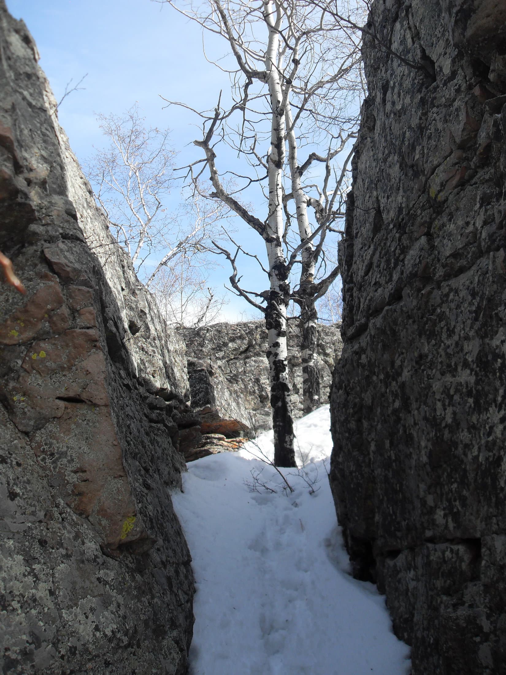
SPHP expected the ledge to slowly sink back into the easier surrounding terrain. Instead, the ledge became even higher. 20 foot cliffs were on both sides. Deep fissures in the rocks, combined with snow and small trees growing up in the cracks made traversing the ledge slow and tricky. At a particularly wide crack in the rocks, Lupe and Sidney finally found a way down through a 40 foot long passage.
Looking back up the deep crack in the rocks that Lupe and Sidney used to get off the rock ledge.
Once off the rock ledge, Lupe and Sidney resumed a steady climb going NW through the forest. Snow was everywhere now, perhaps 1.5 to 2 feet deep on average, with drifts up to 3 feet deep. Lupe didn’t complain, but SPHP began to worry she was going to wear herself out and get cold. Big Sid was well insulated, and being considerably larger, had far less trouble.
SPHP wondered why Lupe hadn’t reached USFS Road No. 203 yet? If she went too far N, she would miss the road entirely. Even though it meant losing elevation, it was time to change course and head SW to find the road. It proved to be farther away than SPHP expected, but Lupe did come to it. She turned N on No. 203, resuming her climb of Minnesota Ridge.
A side road heading W with a sign saying Green Gulch Loop appeared. SPHP remembered this place. Lupe had passed by here on a prior expedition. At the time, Green Gulch Loop had looked like an interesting place to explore. SPHP expected it would take Lupe up and over the ridge to the W then down into Green Gulch.
Not true, as it turned out. The road began promisingly enough going W while gaining elevation, but before long Green Gulch Loop made a big curve back to the S. Lupe and Sid started coming to a number of hillbilly cabins and old campers up on a relatively narrow ridge. Signs at each property said “Private Property”, “Beware of Dog” or “No Trespassing”. The fanciest home featured a big tattered Confederate flag flying on a tall flagpole at an exposed part of the ridge.
Lupe reached a place where it looked like the road ended. A house and garage were practically right on Green Gulch Loop. A sign said “Smile You’re On Camera”. Another sign mentioned a dog. SPHP hesitated, unsure if this was the end or not. Although there were plenty of tire tracks in the snow, none of them were fresh. No people or dogs were evident anywhere. Deep valleys were to the E and W.
After a couple minutes, SPHP decided to see if Lupe and Big Sid could go around this property. Everyone left the road skirting around to the W, away from the house and garage. The maneuver succeeded. Surprisingly, Green Gulch Loop did continue S beyond the home. Lupe and Sid passed by a couple more decaying shacks along the way before they were completely beyond the strange hillbilly camp.
Green Gulch Loop stayed up high until the narrow ridge petered out. Near the end, Lupe and Big Sid lost considerable elevation before arriving at an intersection where several USFS roads headed off in different directions. Lupe had been here before on Expedition No. 51 nearly a year ago on 3-14-13. Since it was time to start thinking about working back toward the G6, Lupe and Sidney took USFS Road No. 204 going E. In about 0.75 mile, it would link up with No. 203.
By now the ice on the road was getting soft and slushy. Wherever there wasn’t ice and slush, there was mud. Fortunately, ice still prevailed. Lupe and Sid were losing elevation, so it was a pleasant stroll. The road turned NE and the intersection with No. 203 came into view ahead. Surprisingly, another intersection was closer. A road led S into a shallow valley with nice open ground. A sign said this was Killoern Springs Road. This road wasn’t shown on the USFS map, but the shallow valley looked appealing. Lupe and Big Sid made the turn S.
After only a short distance, Killoern Springs Road turned W and climbed up out of the shallow valley. However, SPHP recognized this place from Expedition No. 51, too. A pole fence running E/W partially blocked the way farther S down the shallow valley, but an ATV trail could be seen continuing beyond the fence. That was the way to go! Lupe, Sidney and SPHP left Killoern Springs Road, went around the pole fence, and followed the ATV trail.
Lupe and Sidney had a great time in the shallow valley. The ground was nearly level and open. Snow was still present, but far less than had been up on Minnesota Ridge. Both dogs ran around as they pleased. Lupe was excited by several large birds which flew down the valley not very far above her. A small stream appeared, a western tributary of Gimlet Creek. Several times the ATV trail forded the stream, but the creek was so small even SPHP could leap across it.
The ATV trail forded this western tributary of Gimlet Creek several times, but the stream was so small even SPHP could simply leap over it. Photo looks SSW.Due to the melting snow, the tiny stream had good flow.Loopster and Sidney had a great time in the shallow valley leading to Gimlet Creek.
The shallow valley had been slowly turning SE. After nearly a mile, it broadened out and turned directly E. Another 0.25 mile brought Lupe to a small pond she had seen before on Expedition No. 51. A nice bridge crossed the stream again at the dam. Everyone went over the bridge. Gimlet Creek could now be seen off to the E. It flowed down another valley from the N on its way to its confluence with the tributary Lupe and Sid had been following.
Lupe, Sidney and SPHP headed E to Gimlet Creek, then turned N to explore part of this new valley, too. Several more creek crossings were required, but it was still fairly easy to find ways across. At the last crossing, a few boards helped SPHP get over the creek. After going 100 yards farther, SPHP suddenly realized Lupe and Sidney weren’t here! Where were they? Turning around, SPHP saw them back near the last creek crossing. Big Sid was watching Lupe.
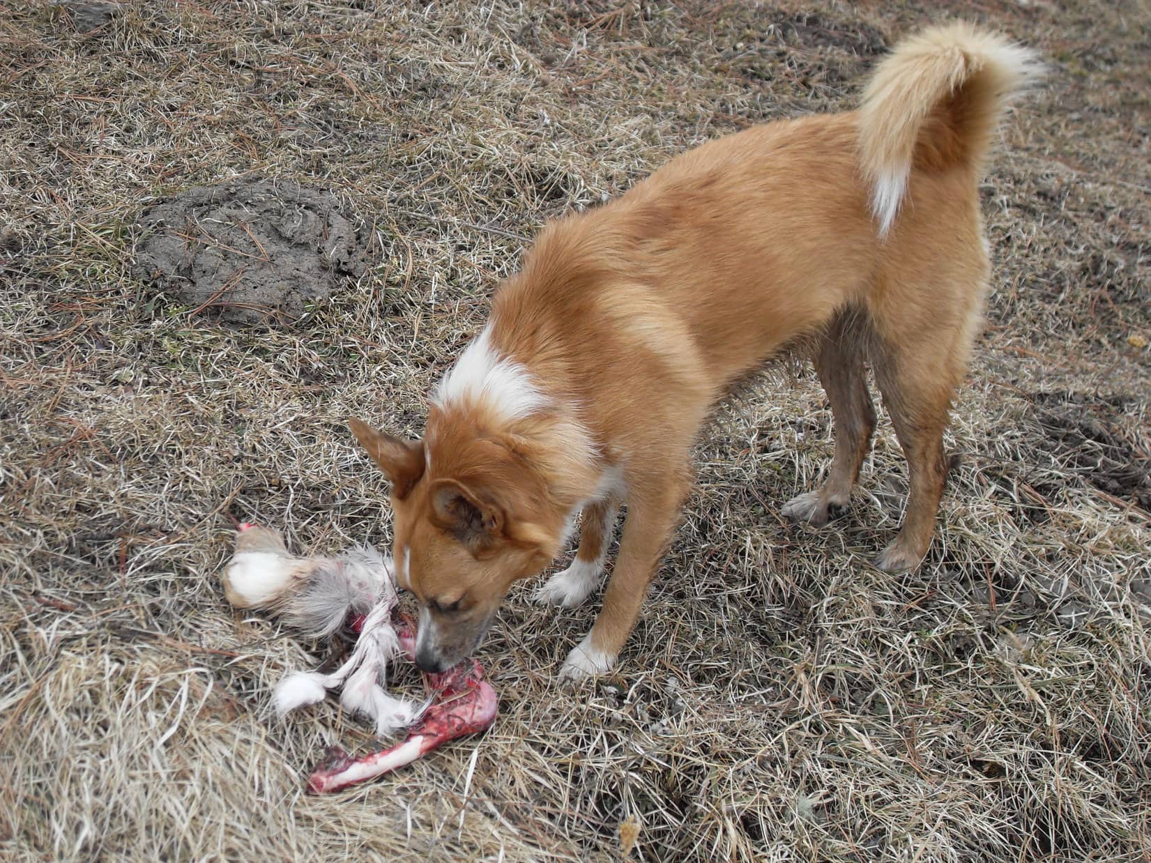
Lupe came running toward SPHP. She was carrying something in her mouth – a piece of deer leg! Lupe had occasionally found pieces of deer legs and carcasses in the forest on prior expeditions, but none like this one. This deer leg was red with blood! Fur, a little meat, and sinewy membranes still clung to the bone.
Lupe considered this deer leg the find of a century! She couldn’t have been happier if she had come across an ancient Egyptian tomb full of golden treasures. To her the deer leg was a treasure! She growled menacing warnings at Sidney whenever he got close. Sidney had the good sense to stay away and show no interest.
Lupe was crazy for the deer leg. She tore at it, cutting pieces of fur and sinew off using her molars like scissors. She devoured what little meat and sinew there was, even though she wound up swallowing a lot of fur in the process. Lupe didn’t care. She acted like a ravenous wolf. It all came very naturally to her. She knew exactly what to do!
It was the find of a century! Lupe was crazy for this deer leg she found in the Gimlet Creek valley. She growled warnings at Sidney whenever he got close.
Lupe wasn’t about to abandon her deer leg, so SPHP watched while Loop did her best to consume every last morsel of meat or gristle she could tear off it.
A savage American Dingo devours a deer in the Gimlet Creek valley!
Finally, after 20 or 30 minutes, hardly anything was left of the deer leg other than fur and bone. SPHP persuaded Lupe that it was time to press on. She agreed with great reluctance. Several times she ran back for her precious deer leg, picking it up and carrying it a bit farther. At last, she finally dropped the deer leg for good.
The valley split into two valleys just ahead to the N. Gimlet Creek flowed down from the valley that went straight N. The other valley was dry and came down from the NE. It was time to try to find USFS Road No. 660 in the Experimental Forest again, which couldn’t be much farther away to the E. Lupe, Sidney and SPHP left Gimlet Creek going up the dry NE valley.
Lupe hadn’t gone very far when suddenly there was gunfire! One shot, then another. It was coming from the direction Lupe was headed. The ferocious, deer-devouring Dingo vanished in an instant. Lupe begged for SPHP’s help. Hide me! Hide me! Hold me! Protect me! Sidney was completely unfazed. He paid no more attention to the gunfire than he had to the rotten deer leg.
Several more gunshots rang out. Lupe was desperate to get away. Sadly, the Carolina Dog wasn’t far from where she and Sidney had earlier seen the herd of 17 elk. SPHP was afraid the beautiful elk were being slaughtered. It was a most depressing thought.
Sidney and SPHP turned SE to flee up and out of the valley, while Lupe kept begging SPHP to stop and protect her. The valley wasn’t all that deep, but an anxious Dingo constantly leaping in the way didn’t make for a quick escape. SPHP gave in and carried the concerned Carolina Dog partway up the hillside.
Shortly after the terrain started leveling out, Big Sid found USFS road No. 660 again. By now a total of 5 or 6 gunshots had been heard. SPHP put Lupe down again. Everyone took off down No. 660 racing away to the S. To Lupe’s enormous relief, no more gunfire was heard. The rest of the way back to USFS Road No. 616 and the G6 was uneventful (5:06 PM, 50°F).
Lupe’s day with Big Sid in the Experimental Forest and on Minnesota Ridge was over, but her Expedition No. 78 adventures were not! A little after midnight, SPHP woke to the sound of a Carolina Dog puking up her spaghetti dinner. Oh, joy! SPHP got up, cleaned up the mess, and snuggled in again with the queasy companion.
Ten minutes later, Lupe gave a repeat performance. This time she threw up fur and grimy deer leg sinews. Another cleanup ensued. Lupe felt much better and slept soundly after that. Expedition No. 78 officially ended in the morning when clean sheets and bedding were restored to the bed after a thorough cleaning in the washer and dryer.
Could there be any doubt, though, that given the chance to do it all over again Lupe would relish devouring the next deer leg she finds in the forest? Of all the treasures Lupe has found on her many adventures, that spoiled rotten deer leg was the most wonderful, glittering prize of all!
Start 8:23 AM, 50°F, USFS Road No. 203.5 just off Rochford Road
Lupe liked the looks of this place – green grass, a bubbling creek, choice of sun or shade. A slice of American Dingo paradise, that’s what it was! Loopster was all smiles.
Lupe was all smiles at the start of Expedition No. 203. She anticipated a great day ahead!
Smiles and energy, that is! Lupe took off running. She bounded through the tall grass wet with dew near Gimlet Creek. Of course, she tested the waters of the creek itself, too. They quickly earned the Carolina Dog seal of approval.
Lupe’s day started close to the confluence of Gimlet Creek & East Gimlet Creek. Here she tests the waters of East Gimlet Creek.
As SPHP started up USFS Road No. 203.5, Lupe raced through fields on both sides of the creek. Sometimes she scrambled partway up the sides of the valley. She was looking for squirrels, but didn’t find any. A great many of the large trees on the hillsides were dead, killed by pine bark beetles.
Lupe remained hopeful, though. The day was just beginning. Having a creek to follow was simply glorious! Loop loved being able to cool off in the stream. At intervals, the road had big mud puddles, too. Lupe strolled through each one, slurping up cloudy brown water as she went. She was definitely getting her mineral requirements met.
Lupe on USFS Road No. 203.5 in lower Gimlet Creek valley. Photo looks N.Lupe got to follow USFS Road No. 203.5 up Gimlet Creek valley for more than 2 miles. Actually, it was SPHP who followed the road. Loop was busy exploring.Looking downstream in the Gimlet Creek valley. The lower part of the valley was fairly narrow as seen here. Photo looks S.Looking NNW up the valley.
Only a week ago, Lupe had found snow up in the hills on Expedition No. 202. No chance of that today. Not even close. Beneath a cloudless blue sky, the day was warming up fast. In fact, the forecast was for near record temperatures in the 80’s °F. From winter to summer with scarcely any transition between. Not good, but not that unusual in the Black Hills.
After 2 miles, the road forded Gimlet Creek. Lupe was already slowing down due to the rising temperatures. She stayed closer to SPHP and the road. Fur coats are wonderful when it’s cool out, but not so great when it’s warm. Lupe’s tongue hung out. She wore a perpetual smile whether she wanted to or not.
By the time Lupe reached the Gimlet Creek ford on USFS Road No. 203.5, she was slowing down. The day was warming up fast, and the heat was starting to get to her. The creek and every mud puddle she came to were welcome sights.
Beyond the ford, the valley widened out considerably.
The valley had become much wider by the time Lupe reached the ford on Gimlet Creek. Photo looks N across the valley, which curves to the E (R) here for a short distance.
About 0.25 mile N of the ford, Gimlet Creek turned E. From a side valley to the W, a smaller tributary stream flowed into a pond before continuing over to its confluence with Gimlet Creek. Several ducks flew away as Lupe drew near the pond.
Getting close to the pond, which isn’t in view quite yet, but isn’t far off to the L. The small tributary stream flows through the fenced-in area seen above Looper on its way to Gimlet Creek on the far R. Photo looks NE.Lupe reaches the pond, the biggest water feature she would see on Expedition No. 203. Several ducks had flown off as Lupe approached. Photo looks NW.A good bridge crossed the small tributary of Gimlet Creek where it exited the pond. Lupe had come up USFS Road No. 203.5 from the direction seen on the L. Photo looks SW.
A family of Canadian geese had made this pond home. When Lupe arrived, they were out for a stroll on the green grass nearby.
Momma and papa goose out for a stroll with their 5 chicks.
The little geese were far too young to fly, so when momma and papa saw Lupe, they led the chicks back to the safety of the water. In the meantime, the ducks had already returned.
By the time Lupe circled around to the N side of the pond, the ducks had already returned. Photo looks S down the Gimlet Creek valley the way Lupe had come.The geese returned to the safety of the water while Lupe was around.
For a few minutes, Lupe and SPHP enjoyed watching the ducks and geese. Unseen frogs sang a noisy tune. It was a pleasant scene, but Lupe was soon eager to press on.
Immediately N of the pond, USFS Road No. 203.5 left the valley and disappeared up a forested hillside. Lupe didn’t follow it. Instead, she went W on a fading side road, which paralleled the tributary of Gimlet Creek. She had to go around deadfall timber blocking the road in a number of places.
The side road soon ended at a marshy area where another small valley came down from the N. Lupe crossed the marsh, still heading W. She stayed in the valley the tributary of Gimlet Creek flowed through. Eventually this valley turned N, too.
The tributary of Gimlet Creek was a very small stream, but did have flow. After the valley turned N, Lupe came across another minor road following this stream. The road forded the tiny creek 5 or 6 times. Lupe was always glad to have another chance to cool her paws off.
A minor road Lupe was following upstream forded the little creek 5 or 6 times. Lupe was always glad to have another chance to cool her paws off or get a quick drink. Photo looks NNE.The tiny stream supported a lush green ribbon of life.
Lupe was 1.25 miles from the pond when she came to a pole fence across the valley. On the other side was a better road. Lupe went around the fence and continued N on this new road. She met a little green snake basking in the sun. Though it was warm out, the snake didn’t move even when SPHP prodded it with a stick.
Why the snake didn’t move wasn’t clear. It looked fine, but perhaps something was wrong with it? The only sign of life it gave was to flicker its tongue when lightly poked.
Lupe came to this small green snake basking in the sun on the road. It wouldn’t move other than to flick its tongue now and then.
The new road quickly brought Lupe to a junction. A sign said Lupe had been on Killoern Springs Road (USFS Road No. 204.1B). The other road at the junction was USFS Road No. 204.1. Lupe sat in the shade of a big pine tree while SPHP checked the maps.
Lupe relaxes in the shade of a pine tree while SPHP checks the maps.Looking NW from the junction of Killoern Springs Road and USFS Road No. 204.1. Pine bark beetle damaged sections of the forest are a common sight in the Black Hills these days.
The maps confirmed that Lupe was now more than 3 miles from where she’d left the G6. She actually did have a peakbagging goal today. She was on her way to Minnesota Ridge(6,240 ft.), the summit of which was still another 2 miles to the NW. Only a little farther N on No. 204.1 was another junction, this one with Minnesota Ridge Road (USFS Road No. 203). In fact, Lupe could see the junction from here.
Minnesota Ridge Road wouldn’t take Lupe all the way to the summit, but it would get her reasonably close. Lupe headed for it.
The march up Minnesota Ridge Road was sunny. The day was very hot for early May. The little stream Lupe had been following had completely disappeared. Lupe panted. Her tongue hung out as she plodded along the dusty road behind SPHP. A couple of times, SPHP stopped to give her water.
The road didn’t climb all that steeply, but it was steep enough. The heat sapped both Lupe’s and SPHP’s energy. A mile from the last junction, the road finally began to level out. Lupe reached another intersection with Greens Gulch Loop.
The road leveled out about the time Lupe reached this intersection with Greens Gulch Loop (unseen to the L). Photo looks N.
SPHP checked the maps again. Lupe could go either way, W on Greens Gulch Loop or N on Minnesota Ridge Road. No matter which way she went, she would have to leave the road before long.
Loop stayed on Minnesota Ridge Road for another 0.25 mile. She reached a big mud hole where frogs were singing noisily.
Frogs singing in this mud hole on the E side of Minnesota Ridge Road ceased their din when Lupe appeared. Lupe was far enough N now. It was time to leave the road to look for the summit of Minnesota Ridge. Photo looks ENE.
Lupe left the road heading WNW through the forest. The true summit of Minnesota Ridge might be as much as 0.5 mile away or even a little more. SPHP was more concerned with how difficult it might be to find the summit, than how far away it was. The topo map showed only a gradual rise in the terrain toward the W. The top of Minnesota Ridge was likely to be flat, forested, and cover a lot of territory.
Although many trees were still green and growing, the forest floor was thick with beetle-killed deadfall timber. Lupe wound around trying to avoid the worst of it. At least it was clear Lupe actually was gradually gaining elevation as she continued WNW. Nothing except more forest was in view in any direction.
After a long wandering way, Lupe started catching glimpses of distant ridges miles away to the W. She was nearing the W edge of Minnesota Ridge, which was the steepest side of the mountain. As she reached what seemed to be the highest terrain, Lupe found a series of boulders scattered along a line running roughly N/S.
Tree broken views of distant ridges farther W appeared as Lupe reached the W “edge” of Minnesota Ridge. A line of boulders ran N/S. Maybe one of them was the true summit? Photo looks W.
Lupe had hardly seen any rocks in the forest until now. Maybe this was Minnesota Ridge’s summit area? It seemed likely. Perhaps one of these boulders would be clearly higher than all the others? Maybe it wasn’t going to be as hard to find the true summit as SPHP expected.
Lupe explored S along the line of boulders. She didn’t have to go too far before it became clear the terrain was definitely going to start dropping off if she went any farther this way.
Lupe on the last big boulder at the S end of the highest terrain. A short exploration to the S from here confirmed that Lupe would lose elevation going any farther that way. Photo looks S.
Once it was established that there was no point in going any farther S, Lupe turned N again. She followed the line of scattered boulders looking for the highest one.
Lupe willingly leapt up on each boulder SPHP thought might be the true summit of Minnesota Ridge(6,240 ft.), but the process soon became somewhat of a comedy. Each time SPHP believed Lupe had been at the true summit, another boulder that seemed clearly a little higher would be found hidden in the forest another 20 to 50 feet farther N.
Lupe on the 1st boulder SPHP declared the true summit. Photo looks NE.On the 2nd “true summit”. Photo looks NW.On the 3rd “true summit”. Photo looks E.Lupe on the 4th “true summit”. This one was well back from the W edge of the mountain, and had an interesting knob of different colored rock firmly fastened on top. There was even a clearing in the forest nearby. Photo looks NW.The 5th “true summit” rock had its own little ecosystem growing on it. SPHP named this one Garden Rock. Photo looks ENE.Looper on the 6th “true summit”, the highest and farthest N in the line of boulders. Photo looks NNW.
Finally after standing on 6 different “true summit” boulders, the line of boulders faded away. The ground to the N seemed to dip slightly, so No. 6 was probably it. To be certain, though, Lupe continued N near the W edge of the mountain. Only when it was clear that the terrain was going to start dropping off decisively would Lupe claim her peakbagging success.
It didn’t happen. Beyond the slight dip, the ground rose slowly again. Lupe went hundreds of feet N before coming to another area where the terrain leveled out. She was almost certainly higher now than she had been back at boulder No. 6. This large area of flat ground was sunny and open. Most of the trees had been killed by pine bark beetles, and had subsequently snapped and fallen over.
SPHP didn’t like it. This area now had to be considered the true summit, but the place lacked charm. All the deadfall was just plain ugly. A couple of modest-sized rocks about equal in elevation were now joint contenders for true summit. Once again, Lupe willingly got on each one.
Boulder No. 7 in contention for the title of true summit. However, No. 8 only 25 feet away was about the same elevation, too. Photo looks SSW.“True summit” No. 8 was in an ugly place with lots of deadfall. Photo looks N.
“True summits” 7 and 8 were in such a hideous place, there was no point in lingering. The terrain to the N was still flat, so Lupe needed to explore it too, in order to make certain this was actually the top of the mountain.
The deadfall was bad for hundreds of feet. Lupe and SPHP made slow progress, but nearing the end of it, a rock ledge appeared ahead. It was definitely at least 5 feet higher than anywhere Lupe had been yet! SPHP was glad. Lupe worked her way over to it.
From the S end of the rock ledge, Lupe could see that the ledge continued on to the NNW for some distance. Lupe was at the top of a line of small cliffs which became larger off to the NNW, but only because the terrain below the cliffs was dropping off faster than the ledge above. The S end of the ledge where Lupe first reached it appeared to be the highest point.
The rock ledge definitely made a better looking “true summit” No. 9. Lupe perched on top while SPHP scrambled down through rocks and deadfall to get her official Minnesota Ridge(6,240 ft.) summit photo.
Lupe perches on “true summit” No. 9 at the S end of the rock ledge. Photo looks N.
Lupe even enjoyed a bit of a view from the ledge, making it even more worthy of being the summit.
The view to the W wasn’t spectacular, but was much better than a bunch of collapsed dead trees.
Lupe and SPHP explored a little farther to the NNW along the rock ledge. The ledge lost elevation gradually in this direction, but continued onward.
Beneath the shade of a big pine tree, not far from “true summit” No. 9 at a point where the views to the W were pretty good, Lupe and SPHP took a break. Lupe crunched some of her Taste of the Wild. SPHP munched an apple. The water in the water bottles was icky warm now, but that couldn’t be helped. Warm water or none at all. Take it or leave it.
After 5 or 10 minutes, a couple of large birds came sailing by. They circled and soared in updrafts near the ledge. They circled around many times, but were moving so fast through the small patch of sky where Lupe had a clear view of them between the pines, it was hard for SPHP to get a good photo.
One of the two large birds soaring on updrafts near the long ledge. The birds circled around to swoop by many times during Lupe’s break.Hawks or eagles? SPHP wasn’t sure. They didn’t seem quite large enough to be eagles.Lupe on a big rectangular rock at the edge of the ledge. Her break area was just off to the L. True summit No. 9 is only a short distance beyond her. Photo looks SSE.On the same rectangular rock.
When the big birds soared away for the final time, Lupe’s break was over. She returned briefly to “true summit” No. 9. Since the terrain 30 to 50 feet back from the edge of the ledge seemed to be slightly higher, Lupe resumed her search for the absolutely highest point.
Nothing really stood out as being the exact spot, so Lupe chose a small rock that looked as high as anything else around for her final “true summit” No. 10 photo. If this wasn’t the real deal, SPHP was convinced it had to be within a foot or two of the actual high point, which might be hidden anywhere among all the deadfall nearby. This was close enough as far as Carolina Dogs are concerned!
True summit No. 10. Even if this wasn’t the actual tippy top of Minnesota Ridge it had to be close. Certainly close enough as far as Carolina Dogs are concerned. Photo looks NNE.
Ten true summits were more than enough for any mountain. Lupe claimed her peakbagging success. Now what? The sun was still high in the sky. Hours and hours of daylight remained. May as well explore NNW along the rock ledge to see how far it went. Maybe there were places with better views than Lupe had seen so far?
Lupe explores farther NNW along the rock ledge. Photo looks SSE.
Lupe did come to a few places where the rock ledge provided better views! All of the views were to the W where Lupe could see the edge of the higher limestone plateau country of the western Black Hills. She could see Nipple Butte(6,800 ft.), Flag Mountain(6,937 ft.) and other high points she had been to before on prior expeditions, but they were all miles away.
Looking SW from the ledge toward the higher limestone plateau country of the western Black Hills.Lupe out on the largest rock platform she found along the entire ledge. Nipple Butte and Flag Mountain are in view on the horizon straight up from her, but they are very far away. Photo looks SW.
The rock ledge eventually petered out. The views were gone. It was clear Lupe really had been to the summit. She had lost enough elevation by now so there was no doubt. With all the time left in the day, Lupe could still do some exploring.
Years ago, back during the days of her early expeditions, Lupe had come to the Minnesota Ridge area on several different occasions, although she had never sought out the summit before today. Somewhere to the W was a road she had followed as a very young Dingo a couple of different times. It would be fun to travel it again. Somewhere to the N was a road she had been on before that would lead her to it.
Lupe and SPHP went N looking for the road. Lupe was losing elevation steadily now. She came to a big field that didn’t seem familiar.
Lupe came to this big field somewhere on the N slope of Minnesota Ridge. SPHP didn’t recognize it. Photo looks S.
The big field led down to another good-sized field, where Lupe discovered an American Dingo display stand.
Lupe on the American Dingo display stand. What else could it be?
From the American Dingo display stand, Lupe headed NW. She picked up a faint road she had never been on before. Eventually it turned W and led her to the USFS road SPHP remembered W of Minnesota Ridge.
Lupe traveled S on this road, which ultimately proved to be USFS Road No. 204.1A. It was fun to recognize a few places along the way. Lupe took a short break at a tiny creek she had been to years before. This creek flows down into Greens Gulch, but Lupe did not follow it as she had done on one prior occasion.
Lupe drank again from this tiny stream that flows into Greens Gulch. It had been years since she’d last been here.
The road went up and down. It was surprising how much of it still seemed familiar, despite the years gone by. The uphill stretches weren’t that long or difficult, but made the heat more oppressive. Lupe had plenty of time. After climbing past one uphill stretch, Lupe and SPHP took a water break.
Yes, the water was warm, but it did feel good to sit down and rest a bit. A few clouds were drifting through the blue sky. Lupe seemed content to lay panting on the ground, watching and listening. Why not? SPHP stretched out, too. The heat made being lazy easy.
SPHP watched clouds. Lupe listened to birds and watched for signs of activity in the forest. Half an hour went by. Then Lupe spotted a deer peering at her through the forest. For a couple of minutes, Lupe and the deer stared at each other. When the deer finally looked away and started moving, it was too much for Lupe. Instinct took over and she was off like a shot. A minute later she was back. Lazy day break time was over.
Lupe’s trek along the road continued. She soon came to a familiar intersection where she turned E on USFS Road No. 204.1. She completed her big loop around the W side of Minnesota Ridge and arrived back at Killoern Springs Road.
On the remaining 3 miles back to the G6, Lupe retraced her route taken earlier in the day. The ducks and Canadian geese were still at the pond. Lupe and SPHP stopped to watch them for 15 minutes before pressing on S down Gimlet Creek valley.
Nearing the pond again. Photo looks E.The Canadian geese were still at the pond. Lupe and SPHP watched them for a little while before pressing on.
The G6 wasn’t far from the confluence of Gimlet Creek and East Gimlet Creek. On her last exploration of the day, Lupe visited the confluence. She drank the refreshing cold water, and cooled her paws off one more time in the combined stream.
Expedition No. 203 had been different from most in recent years. It was more of a throwback to the long treks of Lupe’s early years, with less emphasis on peakbagging. Lupe had really enjoyed Gimlet Creek, the pond, and the easy strolls through the long valleys. She still made it to the top of Minnesota Ridge, and got to see territory she hadn’t been to in years.
The unseasonal heat showed one thing, though. It was soon time to think about heading to higher ground and cooler climes. For a little while yet, that still meant higher terrain in Lupe’s Black Hills. However, it wouldn’t be long before more distant adventures beckoned.
The start of Lupe’s grand summer of 2017 was fast approaching.
(End 6:04 PM, 77°F)
At the confluence of East Gimlet Creek (L) and Gimlet Creek (R) at the end of the day.