Sky Pilot Lake, Beartooth Mountains of Montana (7-17-13)

On 7-16-13, the day after Lupe’s long day spent looking for Fossil Lake (and actually reaching Fizzle Lake instead) in the Beartooth Mountains of Montana, Lupe and SPHP spent an easy day in camp on the Clark’s Fork of the Yellowstone River.  There weren’t nearly so many “bad bugs” (mosquitoes) at camp, so SPHP started feeling more positive about staying in the Beartooths another couple of days.

SPHP still had it in mind that Lupe ought to at least try to reach Sky Pilot Lake before leaving the Beartooths.  Getting there would be a very long day hike.  In the morning, SPHP spent some time looking at maps to consider possible alternate routes.  In the afternoon, a guy named Mick drove up in his motor home and camped by the river near Lupe’s camp.  Mick was originally from England, but had married an American.  Now he and his wife live in Boulder, CO.

Mick was very friendly and quite a character.  He had a start in the music industry in England, but spent most of his career as a welder in the USA.  He had been many places and had lots of stories to tell.  Although Mick was traveling alone, he does own a dog.  Mick was very kind to Lupe, even giving her treats intended for his dog.

SPHP spent hours visiting with Mick.  In the evening, Mick invited SPHP and Lupe in for a tour of his motor home.  Lupe got to spend the whole evening in there “roughing it” in the lap of luxury.  Mick knows lots of famous people from the music industry.  He said he has had a tremendously fun life.  He told some pretty wild tales about the music industry, places he had been, and people he knew.  His nickname in the music industry was “puker” – not terribly charming, but related to the wild partying lifestyle he shared for a while with the rich and famous.

On 7-17-13, Lupe and SPHP woke up pretty early, refreshed from the easy prior day in camp spent visiting with Mick.  Lupe and SPHP were ready to go find Sky Pilot Lake!  SPHP intended to start the trek Beartooth Lake campground, so Lupe and SPHP went there first.  However, SPHP wasn’t able to find a source of water there.  Since the familiar Island Lake campground and trailhead were only a few miles farther E on Beartooth Hwy No. 212, SPHP quickly gave up on a start from Beartooth Lake.  At the Island Lake campground, SPHP got water and Lupe was ready to go.

Lupe left the Island Lake trailhead at around 8:15 AM.  Even though Lupe had taken the trail from Island Lake twice before (once with Lanis in August, 2012 as far as Beauty and Becker Lakes, and a 2nd time just 3 days earlier on 7-14-13 as far as Two Bits Lake), Lupe and SPHP were perfectly happy to take this trail again.  It really is the easiest and most direct route to Sky Pilot Lake from Beartooth Hwy No. 212.  Better yet, the entire trail goes through simply gorgeous alpine territory.

At first, Lupe and SPHP made very good time.  Lupe and SPHP passed Island Lake, Night Lake, Flake Lake, Mutt & Jeff Lakes, Becker Lake and were all the way to Albino Lake by 11:15 AM.  Soon Lupe and SPHP reached Jasper Lake.  From Jasper Lake on, the going became much slower.  Lupe left the trail at the S end of Jasper Lake, and the ground became progressively rougher with more and more boulder fields.  The weather had been cool and overcast, which was great for hiking, but began to clear and became sunny as Lupe and SPHP worked around the E side of Jasper Lake.

Lonesome Mountain from Jasper Lake 7-17-13. Much later in the day, Lupe and SPHP were caught in a storm near this point.

From Jasper Lake, Lupe headed NNW up a rocky ridge towards Two Bits Lake.  On the other side of the ridge was a series of little lakes and ponds scattered among the rocks and grassy areas.  Once up on the ridge, instead of heading N for Two Bits Lake again (which Lupe had reached just 3 days earlier), this time Lupe stayed farther W.  She wound her way around to cross the stream which comes from Two Bits Lake just downstream of Triskele Lake.

Beyond the ridge NNW of Jasper Lake. A portion of Triskele Lake is seen beyond this pond toward the left side of this photo.
Beyond the ridge NNW of Jasper Lake. A sliver of Triskele Lake is seen beyond this pond toward the left side of this photo.
Lupe takes a break not far from Triskele Lake in the Beartooth Mountains.
Lupe takes a break near the pond before reaching Triskele Lake in the Beartooth Mountains.
Lupe investigates something interesting near the stream below Triskele Lake.

Lupe and SPHP were happy.  Lupe was now exploring new country.  It was all wonderful!  Lupe and SPHP climbed NNW up the big ridge beyond Triskele Lake.  Lupe kept coming to one false top after another.  It was very rough country, but not a dangerous climb.

When Lupe finally reached the top of the ridge, there was a grand view from the SE to the SW all the way around to the NW.  There were many high mountains in view.  Relatively close by and most dramatic was Lonesome Mountain (11,399 ft.) back to the S.  Nearby and for the first time, Lupe and SPHP could now see Donelson and Maryott Lakes below to the WNW.

Lupe up on the ridge NNW of Triskele Lake and W of Two Bits Lake. Lupe is enjoying a view of the SE end of Donelson Lake. Photo looks SW.
Donelson Lake and a bit of Maryott Lake beyond. Looks like very interesting territory to explore! Photo looks SW. Beartooth Mountains, Montana.
Donelson (closest) and Maryott (farthest) Lakes. The W arm of Donelson Lake is seen beyond the little ridge at the left side of the photo.
Donelson (closest) and Maryott (farthest) Lakes from higher up. The W arm of Donelson Lake is seen beyond the little ridge at the left side of the photo.

Once up on the ridge, SPHP had expected it to be relatively easy to find High Pass where Lupe needed to go to get to Sky Pilot Lake, but even with the topo map it was hard to figure out exactly which way to go.  Lupe and SPHP kept climbing along the ridgeline heading N and scrambling around the boulder fields trying to figure out which way was the easiest way to High Pass.  The boulder fields really slowed progress down.   SPHP could now see what looked like a line of storms developing to the W, and some big clouds that looked a bit threatening to the N of the high ridge hiding Sky Pilot Lake.

Lonesome Mountain as seen from the ridge W of Two Bits Lake and NNW of Triskele Lake.
Lonesome Mountain (11,399 ft.) as seen from the ridge W of Two Bits Lake and NNW of Triskele Lake.
Our intrepid American Dingo, Lupe, rests above Donelson and Maryott Lakes in the Beartooth Mountains of Montana on 7-17-13.

After much consulting of the maps and gazing at the terrain to the N, SPHP could see 3 possible ways that might lead to High Pass.  The closest one was the westernmost.  SPHP thought Lupe was too far W for it to be the right one, but although steep, it looked relatively easy to climb.

Since it was taking so long to traverse the endless boulder fields, SPHP didn’t want to go to the E to check out the other possibilities.  SPHP decided Lupe would just climb this closest big ridge, which was directly N of the ridge Lupe was on.  It took a while to get up there, but Lupe and SPHP finally got to the top.

Lupe reaches the top of the ridge about 0.67 mile NNE of Donelson Lake and just W of High Pass. This was her high point reached at around 11,120 feet. The jagged mountains N of High Pass are now in view.

At the top was a huge view in almost every direction.  For the first time Lupe and SPHP could see farther N.  SPHP had been right.  Lupe’s climb up to this N ridge was W of the best access to High Pass.  A few hundred feet below, Lupe and SPHP could see High Pass and High Pass Lake.  Some dramatic towering jagged mountains including Sky Pilot Mountain (12,047 ft.) were in view beyond High Pass Lake.

High Pass Lake. SPHP believes the mountain at the L is a false peak of Sky Pilot Mountain (12,047'). The mountain seen in the center beyond the gap is probably Whitetail Mountain (12,551'). Beartooth Mountains, Montana, 7-17-13
High Pass Lake. SPHP believes the mountain at the L is the SE ridge and a false summit of Sky Pilot Mountain (12,047 ft.). The mountain seen in the center beyond the gap is probably Whitetail Peak (12,551 ft.).  Photo looks NNE.  Beartooth Mountains, Montana, 7-17-13
Lonesome Mountain from the ridge just to the W above High Pass. Photo looks S.
Lonesome Mountain from the ridge just to the W above High Pass.  In the far distance beyond Lonesome Mountain to the L a small portion of Island Lake is seen.  The far side of the lake is where Lupe started this long day hike!  Photo looks S.

By now the storm clouds to the W & N looked closer.  SPHP realized there wasn’t a lot of time to dawdle.  High Pass is 10,800+ feet and Lupe had climbed several hundred feet higher than that.  Lupe was probably somewhere around 11,120+ feet.  Lupe and SPHP worked on down the other side of the ridge into High Pass.  Despite the need to hurry, it was slow going.  Once down in the pass, the going was much easier.  Lupe and SPHP headed N past High Pass Lake up to a small ridge.  SPHP hoped to see Sky Pilot Lake from this ridge, but was disappointed when it was not visible from there.

There was one more ridge to the N, a bit lower, but which was hiding some land in a big cirque.  SPHP thought Sky Pilot Lake might be just beyond that ridge.  SPHP certainly hoped it would be.  SPHP could see that there was a gigantic canyon ahead heading off to the NE.  Lupe shouldn’t go very far down into the gigantic canyon to find Sky Pilot Lake, given the developing weather conditions.  This last ridge was as far as SPHP was willing to go.  So Lupe went down to the lower ridge.  The first thing that Lupe saw was the upper end of the big cirque beyond the ridge.

The big cirque as viewed from the final (lower) ridge. Snow, yes, but not looking like a glacier to SPHP!
The big cirque as viewed from the final (lower) ridge. Snow, yes, but not looking like a glacier to SPHP no matter what the topo map showed!

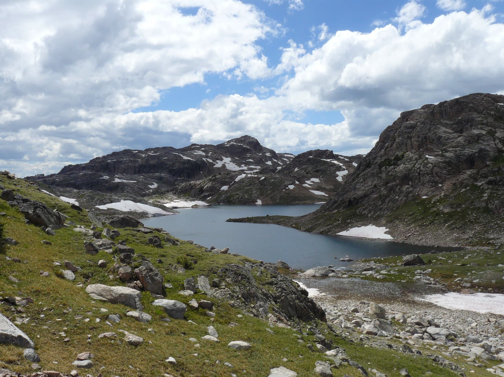
The topo map showed a glacier in the big cirque.  Although there was a considerable amount of snow, it really didn’t look like much.  It certainly didn’t look like there was a glacier any more.  More disappointingly, Sky Pilot Lake was not visible.  Lupe and SPHP headed a bit further to the NNE up to the end of the ridge.  There, nearby, but hundreds of feet below Lupe, was Sky Pilot Lake!  Lupe had succeeded in finding it!

Lupe rests on the final ridge above beautiful Sky Pilot Lake in the Beartooth Mountains of Montana 7-17-13
Sky Pilot Lake (10,478 ft.) shines beautifully in the sunlight. Whitetail Peak (12,551 ft.) is shrouded by clouds to the N.

Sky Pilot Lake was a very beautiful lake!  It shimmered with a gorgeous blue-green color when the sun shone on it.  SPHP wished it hadn’t taken so long to get here, because it would have been great to go down to the shore of the lake and see it from there. However, it was getting late and the weather looked increasingly ominous.  It clouded up, but then blue sky came out again.  Lupe and SPHP sat high up near the end of the little ridge looking at the great view of Sky Pilot Lake.  Lupe rested and had some Taste of the Wild and water.

The SE arm of Sky Pilot Mountain, which is a false summit.
Looking E from the ridge SW of Sky Pilot Lake and N of High Pass. The mountain at L may be the W side of Beartooth Mountain (12,351').
Looking E from the ridge SW of Sky Pilot Lake and N of High Pass. The mountain at L may be the W side of Beartooth Mountain (12,351 ft.).
SE arm and false summit of Sky Pilot Mountain (L) and Whitetail Peak (center).

Lupe and SPHP had been there maybe 20 minutes or more when Lupe started hearing thunder in the distance.  Reluctantly, SPHP decided Lupe had better get going.  After a last glance at Sky Pilot Lake, as fast as SPHP could manage, Lupe and SPHP scrambled back over to High Pass and High Pass Lake.  Soon it completely clouded up and started to sprinkle.  SPHP had raingear in the backpack, but did not stop to put it on.

Lupe got over High Pass and had just barely started down the S side of the pass when the storm hit with driving rain.  Soon there was hail, too.  The hail was only pea-sized, but still stung a bit. SPHP saw an especially big rock nearby with a little bit of an overhang.  Lupe and SPHP headed for it.  Arriving at the big rock, SPHP got Lupe under the overhang and out of the hail.  There was room for SPHP’s head under there too, but that was it.  At least the backpack provided some protection, too.  Still, it was a good thing the hail didn’t get any bigger, or SPHP would have been pounded.  Lupe and SPHP hid there under the overhang for a few minutes while it hailed and SPHP got drenched.

The hail let up pretty soon.  Lupe and SPHP got going again.  It was still raining, but not as hard.  More concerning, lightning was now not too far away, and there was frequent thunder.  The lightning was really the scariest thing.  Lupe needed to lose elevation as fast as possible.   Lupe and SPHP were way too high up and easy targets.  As far as SPHP could see to the W (and SPHP could see a long way from here!), there were more storm clouds.

Lupe and SPHP scrambled onward.  Sometimes it rained harder again, but mostly it was relatively light.  Thankfully, it didn’t hail again.  From the sound of the thunder, lightning was close, but still a little ways away.  Lupe and SPHP made it all the way down through the biggest boulder fields and crossed the stream below Triskele Lake again.  Lupe and SPHP were utterly alone.  The scenery seemed even more beautiful, dramatic and wild in the storm.  Once past the stream, Lupe and SPHP headed up and over the ridge to the S and down to Jasper Lake.

Lupe and SPHP were heading around the E side of Jasper Lake when the storm hit hard again.  It poured rain and hailed again, but the hail was so tiny it didn’t do anything.  This time though, the lightning was now close.  It flashed all around and thunder roared, echoing in the mountains.   Lupe and SPHP crouched down beside a big boulder not far from the shore of Jasper Lake.  There Lupe waited for the storm to pass.  It was an amazing view.  The surface of Jasper Lake danced with raindrops while lightning struck Lonesome Mountain on the other side of the lake.

After 10 or 15 minutes, the rain let up quite a bit.  The lightning and thunder moved away to the E.  Lupe and SPHP got going again.  Lupe and SPHP got up over the ridge S of Jasper Lake and started heading for Albino Lake.  Although occasionally thunder and lightning threatened again, it was never as bad as at Jasper Lake and never again caused Lupe to seek cover.  It rained, but not hard.  Eventually the rain diminished to become just a light sprinkle.  At times it quit entirely.  The clouds broke up and the half moon was out.

Lupe had fun exploring.  There no more mishaps the rest of the way to the G6.  It got so dark, SPHP had to start using the flashlight before Lupe was even back to Mutt & Jeff Lakes.  For hours, Lupe continued to see lightning in the darkness far to the SE.  SPHP was tired, but still felt amazingly good.  Lupe seemed to feel the same way.  Lupe made it back to the G6 back at the Island Lake trailhead at 11:42 PM.  It was 50°F.

By 12:30 PM, Lupe and SPHP were back at camp at the Clarks Fork of the Yellowstone River.  It looked like it had really rained hard there.  SPHP was tempted to sleep in the G6, but Lupe wanted to go in her “tiny house” (tent).  So SPHP got rid of the water in the tiny house and put things in order.   Sometime around 1:00 AM, Lupe and SPHP sacked out in the tiny house.

At nearly 15.5 hours, this was Lupe and SPHP’s longest day hike in the Beartooths on her 2013 Dingo Vacation, and the most spectacular.  It had also been the most dangerous, when Lupe and SPHP got caught in the storm up in High Pass at around 10,800 feet elevation.  Sometime it would be fun to explore the high country around Donelson and Maryott Lakes.  SPHP was very happy Lupe did get to see Sky Pilot Lake, which was very pretty and remote.  The peaks nearby and the gigantic canyon to the NE below Sky Pilot Lake were most impressive too.

A year later, Lupe returned to the Beartooth Mountains as part of her 2014 Dingo Vacation.  On 8-3-14 she climbed Lonesome Mountain, which she had passed by this day on the way to Sky Pilot Lake.

Whitetail Peak beyond Sky Pilot Lake, Beartooth Mountains, Montana 7-17-13

Links:

Next Adventure                    Prior Adventure

Lonesome Mountain in the Beartooth Mountains of Montana (8-3-14)

Want more Lupe adventures?  Choose from Lupe’s 2013 Beartooths & Canadian Rockies Adventure IndexDingo Vacations Adventure Index or Master Adventure Index.  Or subscribe free to new Lupe adventures.

The Journey to Two Bits Lake, Beartooth Mountains (7-12-13)

Lupe and SPHP first came to explore the Absaroka-Beartooth Mountains of NW Wyoming and S Montana in August, 2012 on Lupe’s first ever big summer Dingo Vacation.  Lanis had been along then, too.  Lupe and SPHP were completely enthralled with these beautiful mountains full of alpine lakes, streams and forests, and eager to return in 2013.

This glorious long day hike starts at Island Lake (elevation 9,518 ft.) in NW Wyoming and gains less than 1,000 ft., with a high point of around 10,360 ft. on a ridge reached N of Jasper Lake shortly before arriving at Two Bits Lake.  Lupe and SPHP found no discernable trail the last part of the hike beyond Jasper Lake.  The hike passes just E of Lonesome Mountain, the highest peak Lupe has ever climbed to date (6-23-15), although she didn’t climb it until 2014, about a year after making the hike that is the subject of this post.

Clicking on this blue Lonesome Mountain link will take you to the Peakbagger.com page for Lonesome Mountain which features a topographic map of this area.  Clicking on this red Lonesome Mountain link will take you to Lupe’s blog post on climbing Lonesome Mountain in 2014. 

The Island Lake trailhead is near the Island Lake campground on the N side of Beartooth Highway No. 212 in NW Wyoming.  (Both use the same access road off the highway.)  The Island Lake campground is approximately 2 miles E of the Top of the World Store & Motel or roughly 15-20 miles E of Hwy 212’s junction with the Chief Joseph Scenic Byway, Hwy 296.  Lanis & SPHP purchased topographic maps of the area at the Top of the World Store in 2012.

Lupe woke up early on the 3rd day of her 2013 Dingo Vacation to the Beartooths and Canadian Rockies.  She and SPHP had spent the night in the G6 due to rain, after having claimed their favorite camping spot on the Clark’s Fork of the Yellowstone River the day before.  It was early, but already light out.  The sky was mostly cloudy, but it was no longer raining or even threatening to rain.  Lupe and SPHP got out of the G6 eager to greet the new day in the Beartooths.

Set up on the Clark's Fork of the Yellowstone, July 2013
Set up on the Clark’s Fork of the Yellowstone, July 11, 2013

Swarms of mosquitoes were eager to greet Lupe and SPHP, too.  Lupe and SPHP beat a hasty retreat back into the G6.  Lupe snoozed another 30 minutes while SPHP made journal entries.  Eventually a squirrel woke Lupe up and she just had to get out to bark at it.  She buried the only “Minties” bone SPHP has ever given her under a tree near the tent.  SPHP resolved to retrieve it after checking out the maps for a place to go exploring.

Back in August, 2012, Lupe, SPHP and Lanis had taken a fabulous hike from the Island Lake trailhead to Beauty Lake and then doubling back to a side trail to Becker Lake.  SPHP decided exploring the area above tree line beyond Becker Lake would be great fun for Lupe.  By 10:00 AM, Lupe was setting out on the trail from Island Lake.  Lupe passed by lakes she had first seen with Lanis in 2012 including Island Lake, Night Lake and Flake Lake.  Lupe was making great progress along the trail, partly because mosquitoes became a big problem anytime SPHP stopped for even a few moments.

SPHP was watching for a side trail angling to the right that led to Mutt & Jeff Lakes and then went on to Becker Lake and beyond, and yet somehow missed it.  When the trail started to curve to the left and rapidly lose elevation, SPHP remembered it was about to descend to Beauty Lake.  SPHP realized Lupe had gone too far.  Lupe and SPHP turned around and went back in search of the side trail to Becker Lake and beyond, and this time found it.  Upon reaching Mutt & Jeff Lakes, SPHP knew for certain Lupe was headed in the right direction.

Mutt & Jeff Lakes are very close together.  The trail goes between the two lakes, crossing a broad connecting stream.  There is no bridge, but there are quite a few rocks in the stream and stranded bits of grassy or bushy land.  SPHP managed to hop across from rock to rock without getting non-waterproof boots too wet.  Lupe had no problem leaping from one rock to the next, or just wading through enjoying the cold, clear water.

Once across the stream, the trail turns NE and crosses a boulder field that extends right down to the NW shore of Jeff Lake.  Past Jeff Lake, the trail heads N up a small headwall and then along the E side of a shallow pond (more boulders here) in a saddle.

Jeff Lake in the Beartooth Mountains. The trail crosses the boulders at the base of the hill (L) and then goes up around the right side of the hill.
Jeff Lake in the Beartooth Mountains. The trail crosses the boulders at the base of the hill (L) and then goes up around the right side of the hill.  Mutt Lake is just to the left of this photo.  (Not pictured.)
Mutt Lake.
Mutt Lake.

Soon after passing the saddle, a portion of the S end of Becker Lake came into view.  Lupe followed the trail N through the woods well above the E shore of Becker Lake.  Towards the N end of Becker Lake, the trail was out in the open and closer to the lake.

There were just scattered groups of trees around as Lupe and SPHP left Wyoming N of Becker Lake and entered Montana on the way to Albino Lake.  The trail stayed on the E side of the stream coming down from Albino Lake to Becker Lake.  The last few trees were at Albino Lake (10,000 feet elevation), which is situated just E of Lonesome Mountain.  Lupe loved the open ground of the high country, although without trees there was the drawback of no more squirrels to bark at.

Part of the S end of Becker Lake.
Lupe near the trail E of Becker Lake.
Lupe near the trail E of Becker Lake.  Photo looks N.
Looking S from the trail on the E side of Becker Lake.
The stream coming down from Albino Lake on its way to Becker Lake. Photo looks N.
Lonesome Mountain (L) lies just W of Albino Lake. This photo is taken looking NW from the trail near the stream flowing out of Albino Lake.
Lonesome Mountain (11,399 ft.) (L) lies just W of Albino Lake. This photo is taken looking NW from the trail near the stream flowing out of Albino Lake.
Albino Lake and Lonesome Mountain. Photo looks WNW.
Looking S back at Becker Lake from a hill S of Albino Lake.
Albino Lake from the hill to the S.
Albino Lake from the hill to the S.  Lonesome Mountain at left side of photo.
Lupe happy in the Beartooth Mountains S of Albino Lake 7-12-13
Happy Lupe in the Beartooth Mountains S of Albino Lake 7-12-13
Lupe on the hill S of Albino Lake. Photo looks N.
Lupe on the hill S of Albino Lake.  From here Lupe went around the left (W) side of the lake and climbed over the ridge shown on the far side of the lake at the low point seen at left center.   Photo looks N.

At the SE end of Albino Lake, Lupe crossed over the outlet stream (easy rock hopping) to the W.  Lupe and SPHP went up on a hill just S of Albino Lake for a look back towards Becker Lake.  Then Lupe followed the trail NW above the W shore of Albino Lake up to the next big saddle ridge ahead.  From the saddle was Lupe’s first view of Jasper Lake.  The area around Jasper Lake was completely devoid of forest.  Rock, heather, scattered patches of snow and sky was all there was.  Gorgeous high mountain terrain was everywhere.

Jasper Lake in the Beartooth Mountains.
Jasper Lake in the Beartooth Mountains.  Photo looks N.
Jasper Lake
W side of Jasper Lake.  Photo looks N.
The NW end of Golden Lake visible from the ridge S of Jasper Lake. Photo looks WSW.
The NE end of Golden Lake visible from the ridge S of Jasper Lake. Photo looks WSW.

Lupe and SPHP were not alone, however.  Soon after reaching the saddle with a view of Jasper Lake, a troop of backpackers came traipsing up the trail from the NW.  Lupe ran over to greet them, but they soon passed on by.  The rest of the afternoon, Lupe and SPHP saw no one.  After a break enjoying the view of Jasper Lake, Lupe and SPHP continued NW on the trail, which went down to the outlet stream from Jasper Lake near the SW corner of the lake.  This stream had a lot of flow in it.

Lupe greeted these backpackers, some of the very few people Lupe saw this day. Golden Lake in background.

SPHP didn’t want to get wet feet, so Lupe and SPHP followed the S shore of the stream down all the way to Golden Lake, which wasn’t far off to the WSW.  There was no place to cross and stay dry anywhere along the way.  There was nothing to be done, except take the plunge.  SPHP and Lupe forded the stream at the delta where it enters Golden Lake.   Now on the N side of the stream, Lupe and SPHP headed back up towards the W shore of Jasper Lake.  Nearing the lake again, Lupe turned N heading for a ridge.

Stream flowing down from Jasper Lake.
Lupe near Golden Lake. Photo looks SW.
Lupe near Golden Lake. Photo looks SW.  Lonesome Mountain is on the left.
SPHP's boots got soaked crossing this stream where it enters Golden Lake. Lonesome Mountain on left. Photo looks SW.
SPHP’s boots got soaked crossing this stream where it enters Golden Lake. Lonesome Mountain on left. Photo looks SW.

Lupe and SPHP gained the top of the ridge NNW of Jasper Lake at a broad shallow saddle.  The saddle area and beyond consisted of rolling terrain strewn with a mix of boulder fields, grassy areas and small shallow lakes.  Crossing this ridge, Lupe reached her highest elevation of the day at somewhere between 10,360 and 10,400 feet.  Beyond the ridge was Two Bits Lake.  Lupe spotted a snow drift and ran down to cool off in it not far from the lake.

Looking back at Lonesome Mountain from the N on the way to the ridge NNW of Jasper Lake.
Looking back to the SE at Jasper Lake.
Looking back to the SE at Jasper Lake.  The ridge Lupe came over from Albino Lake is on the right side of the photo.
Largest of the unnamed lakes in the saddle area NNW of Jasper Lake.
Lupe on her snowbank near Two Bits Lake. Photo looks NNW.

Just S of Two Bits Lake, Lupe and SPHP stopped for a break.  Lupe chowed down on some Taste of the Wild.  SPHP celebrated success with a Coke.  After the break, Lupe and SPHP explored among the rocks above the S shore of Two Bits Lake.

Consulting the topo maps, SPHP really wanted to climb another ridge NW of Two Bits Lake and then turn N to find High Pass with the ultimate goal of reaching Sky Pilot Lake.  However, the day was wearing on and it was a long way back to the G6.  It was too late in the day to try it.  If Lupe was ever going to reach Sky Pilot Lake, she would have to come back to Island Lake and start all over again earlier in the day.

Two Bits Lake, Beartooth Mountains 7-12-13. Photo looks NNW.
Lupe takes a break SSE of Two Bits Lake.
Lupe S of Two Bits Lake
W side of Two Bits Lake. Photo looks N.

After suitable time spent admiring pretty Two Bits Lake, Lupe and SPHP followed a rock ridge SW from the lake.  Just to the NW was the outlet stream from Two Bits Lake running down to Triskele Lake.  When Lupe reached Triskele Lake it was time to turn back.  Lupe headed back up to the saddle area on the ridge NNW of Jasper Lake.  The view of Lonesome Mountain and Jasper Lake was just awesome.  Lupe saw a bald eagle fly over Jasper Lake heading E.

SPHP thought about climbing this ridge to look for High Pass and Sky Pilot Lake, but it was too late in the day to be advisable. Photo looks NW and shows SW corner of Two Bits Lake.
Looking SW down the stream from Two Bits Lake on its way to Triskele Lake.
Triskele Lake in the Beartooth Mountains from the NE.
SPHP's favorite photo of Lupe and Lonesome Mountain. Photo was taken looking S from NNW of Jasper Lake. Lonesome Mountain is much more impressive from this angle than from along the trail to the E or S.
SPHP’s favorite photo of Lupe and Lonesome Mountain. Photo was taken looking S from NNW of Jasper Lake. Lonesome Mountain is much more impressive from this angle than from along the trail to the E or S of the mountain.  A portion of Golden Lake is seen at center right.

SPHP wanted to go around the E side of Jasper Lake to avoid having to ford the big outlet stream again.  On the NE side of Jasper Lake, Lupe found a big feather near a little stream.  Perhaps it was from the bald eagle?  That was pretty cool!  There were lots of streams coming into Jasper Lake from the E, but since they were smaller, SPHP managed to stay mostly dry getting across them.   Eventually Lupe and SPHP reached the ridge to the S of Jasper Lake and found the trail again.

The eagle feather is seen just to the left of Lupe. Photo taken NE of Jasper Lake.
Lonesome Mountain across Jasper Lake from near the eagle feather.
Lonesome Mountain across Jasper Lake from “Eagle Feather Creek”.
Jasper Lake & Lonesome Mountain, 7-12-13
A last look back N at Jasper Lake.

The rest of the evening was spent retracing the trail back to the G6.  Lupe and SPHP had seen very few people all day, but on the way back SPHP did stop to talk to a fisherman on the W side of Albino Lake.  He was catching mostly 8-12″ cutthroat trout, but said he had caught a couple of 18-20″ cutthroats up at Golden and Jasper Lakes.  The fisherman was from Pennsylvania.  He claimed to have seen a white wolf.

Lupe reached the G6 again at 11:28 PM.  Lupe had been sniffing and exploring for 13.5 glorious hours!  By now, though, both Lupe and SPHP were about totally played out.  The weary dingo hopped into the G6 and curled up for a snooze.  SPHP drove back to the campsite at the Clark’s Fork of the Yellowstone River.   Arriving well after midnight, SPHP was just too tired to set things up in the tent.  SPHP covered Lupe with a blanket.  Another night was spent in the G6.  The next morning, a bleary-eyed dingo was still curled up, happily snuggled in the blanket.

Carolina Dog catches 40 winks. More adventuring lies ahead!

Although Lupe did not get as far as Sky Pilot Lake this time, 3 days later she returned and did find it.  Click on this Sky Pilot Lake link to see her post on that adventure!

Links:

Next Adventure                   Prior Adventure

Castle Mountain, the Carbon County Montana High Point with Mountaineer Jobe Wymore – Part 1: Island Lake to Two Bits Lake (8-7-20)

Want more Lupe adventures?  Choose from Lupe’s 2013 Beartooths & Canadian Rockies Adventure IndexDingo Vacations Adventure Index or Master Adventure Index.  Or subscribe free to new Lupe adventures.