Poot Peak, Kachemak Bay State Park, Alaska (9-1-18)

Day 29 of Lupe’s 2018 Dingo Vacation to the Yukon, Northwest Territories & Alaska!

7:40 AM, Homer Spit – Ten minutes after Mako’s Water Taxi opened, Lupe sauntered in.  The American Dingo had such a good time on the Alpine Ridge trail going to see the Grewingk Glacier yesterday, that SPHP wanted to find out if there was any chance she might be able to return to Kachemak Bay State Park for an attempt on Poot Peak (2,585 ft.)?

Absolutely!  Lupe can depart Homer Spit aboard the Orca at 8:00 AM, with a 4:30 PM pickup at Halibut Cove Lagoon.  $85.70 total round trip for SPHP, all fees and taxes included, and Dingoes ride free.

Wow!  Sounded great!  Without the slightest hesitation, or even giving it a moment’s thought, SPHP agreed.  After forking over a credit card for payment, Lupe was all set.  Half an hour later, the Carolina Dog was aboard the Orca racing across Kachemak Bay toward Halibut Cove for the second day in a row.

Sea-faring Dingo Lupe aboard the Orca.
Leaving the Homer Spit on Kachemak Bay.

Lupe and SPHP stayed up front sitting on a tote box outside the skipper’s cabin.  The sky was clearer, and the wind greatly diminished from the conditions prevailing yesterday.  The voyage aboard the Orca was much smoother than the bumpy, sometimes jarring, ride over choppy seas aboard the Smokey Bay the day before.  Colder out today, though.  SPHP’s hands were soon freezing hanging onto the metal railing.  Should have worn gloves!

The only other passengers, a couple from Illinois, stayed in the heated cabin.  Once across Kachemak Bay, the Orca dropped them off at the Glacier Spit trailhead.  Lupe was next!  Poot Peak (2,585 ft.) was in sight as the Orca entered Halibut Cove Lagoon on the way to the big dock at the S end near the ranger station.

So that’s Poot Peak there on the R? Looks kind of steep, doesn’t it, SPHP? Aboard the Orca in Halibut Cove Lagoon. Photo looks S.

The skipper pointed out sea otters playing in the lagoon.  The little wakes they made in the water gave away their positions, but they were too far from the Orca to get a good look at them.  A few minutes later, Lupe was disembarking at the huge dock.  As soon as Lupe and SPHP were safely off, the Orca turned and sped away.

At the huge dock at the S end of Halibut Cove Lagoon.
The Orca departs. Photo looks N across Halibut Cove Lagoon.

8:40 AM, Halibut Cove Lagoon dock – As the Orca receded, Lupe and SPHP turned and went up the metal ramp leading away from the dock to the ranger station.  An impressive sign welcomed Lupe to Kachemak Bay State Park, but the ranger station was closed.  SPHP filled in the registry, and took a look at the posted map of the trail system.

Cool sign, don’t ya think, Loop? …… Yes, indeed, SPHP! Kind of reminds me of the sign at that other park. What was it again? Jurassic Park, I think. Be sure to say something if you see any T Rexes or Velociraptors lurking about!
Trail system map posted at the ranger station.

Past the ranger station, a long stairway led down to a small clearing.  Two big planks crossed a tiny stream, beyond which a trail disappeared up into the forest.  Lupe followed this trail as it snaked higher through a thick jungle of ferns and bushes beneath a canopy of tall trees.

Crossing the little stream beyond the ranger station.

Five minutes out, suddenly a disturbance occurred in the forest not far from the trail.  Lupe started running ahead to investigate, but SPHP called her back.  Branches cracked, and bushes shook only 25 feet away, but nothing could be seen of the cause.  A moose?  More likely a bear.

Whatever it was, was so close to the trail that trying to get past it might be asking for trouble.  As the cracking and shaking drew nearer, Lupe and SPHP backed quietly away.  After several short retreats, Loopster couldn’t take it any more.  The Carolina Dog whimpered softly.

Immediately a great commotion erupted.  Violent cracking and shaking!  Something big was fleeing!  Lupe was tremendously excited, but didn’t budge.  Ten seconds, and the jungle fell silent again.  Carefully making sure the coast was clear, Lupe resumed her explorations along the trail.

Probably a T Rex making itself scarce. They know Dingoes rule the earth these days!

A junction was just ahead.  Lupe could go R to the official Halibut Cove Lagoon trailhead, which was different from, and a bit W of, the ranger station trailhead.  The other option, and correct choice, was L on the China Poot Lake trail.

After following the China Poot Lake trail S for half an hour, Lupe came to a high point where a spur trail on the R went steeply down to the shore of First Lake.  Why not?  Would only take a few minutes.  Lupe found lily pads floating on the still waters of a sheltered cove, but the spur trail didn’t go any farther.

First Lake.

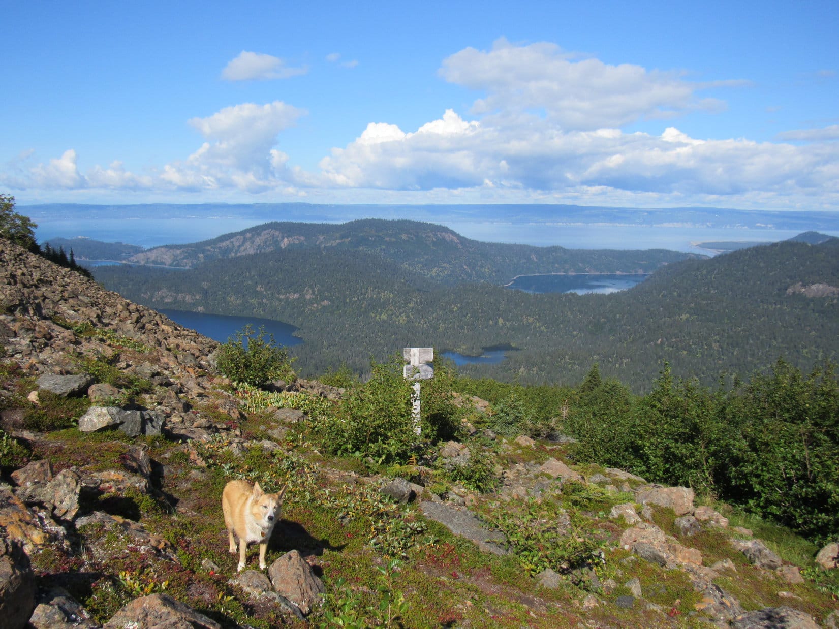
By now, Lupe had gained 500 feet of elevation since leaving Halibut Cove Lagoon.  The China Poot Lake trail leveled out as it crossed a broad ridge heading SSE.  Nothing could be seen except the surrounding jungle.  The trail was easy to follow, although tree roots made the pathway uneven.

Deep in the green jungle along the China Poot Lake trail.

Once Lupe made it across the broad ridge, the trail began switchbacking down a slope before turning E.  For the first time since she had been aboard the Orca, Loopster started catching glimpses of Poot Peak.  The mountain was still surprisingly far away.

Poot Peak from the China Poot Lake trail. Photo looks SSE.
Poot Peak with help from the telephoto lens. Photo looks SSE.

After going E for a bit, the trail turned SE.  Lupe soon came to a junction with the Moose Valley trail.  The China Poot Lake trail turned SW (R) here, while the Moose Valley trail continued SE.

At the intersection with the Moose Valley trail.

Loopster stuck with the China Poot Lake trail.  She caught glimpses of Two Loon Lake off to the SE (L), before coming to several side trails, all of which went W (R).  Ignoring the side trails, Loop crossed a bridge over a rushing stream, and then a second bridge over a dry wash.

Sign at an intersection with the Coalition Loop trail.
At the junction with a short spur trail to the public use cabin on China Poot Lake.
Crossing the bridge over the dry wash.

When Lupe reached it, China Poot Lake was a bit of a disappointment.  The American Dingo was heading S on the China Poot Lake trail only a few feet from the E shore, but trees and bushes still managed to prevent her from getting any clear views of the lake.  Part of this section of the trail was slow going, too.  Full of exposed roots, the trail made a series of small steep climbs and descents on an embankment crowding the shore.

A rare glimpse of China Poot Lake, even though the trail went right by it. Photo looks W.

11:10 AM – Shortly after the trail left China Poot Lake heading SE, Lupe arrived at a junction with the Poot Peak North trail.  Checking the time, SPHP’s heart fell as a sudden realization began to sink in.  The American Dingo’s attempt on Poot Peak (2,585 ft.) was almost certainly doomed to failure!

2.5 hours had already gone by.  The Poot Peak North trail was supposed to take 3 to 4 hours round trip, plus an additional 1 to 2 hours on the Summit spur to reach the top of the mountain.  That totaled 4 to 6 hours to summit and get back here, plus another 2.5 hours to return to Halibut Cove Lagoon.  If those figures were right, Lupe wouldn’t be back ready for pickup until 6.5 to 8.5 hours from now, or 5:40 PM to 7:40 PM.

Scheduled pickup was 4:30 PM.  The gal at Mako’s had said they might run 15 minutes late, but Loop would still be at least an hour later than that.  Only yesterday Lupe had run out of time to complete all that she’d hoped to do up on the Alpine Ridge trail, and this situation was far worse.  How could SPHP have let this happen?  Why hadn’t the slightest attention been paid to how long it would take simply to get to Poot Peak before booking the water taxi?

Not a single valid excuse.  Lupe wasn’t going to make up Poot Peak, and it was all SPHP’s fault.

At the start of the Poot Peak North trail.

Oh, Loopster!  I’m so sorry!

Why, what’s wrong, SPHP?

I’m not used to these timed events.  If I’d given it even 30 seconds thought I would have insisted on a pickup time 2 or 3 hours later, or just told Mako’s to forget it.  I was so excited that a water taxi was available to get us over here right away this morning, that I didn’t stop to consider how long this was going to take.  We can’t make it to Poot Peak.  It’s already too late in the day.  You’ve come all this way, but we’ll be forced to retreat before you stand any chance of reaching the summit.

So this is it?  Do we have to turn around now?

No, not yet.  We can probably go another hour and 20 minutes, and that’s pushing it.  We will have only 3.5 hours to get back.  I can’t believe it!  Looks like we are going to spend all day running around in the jungle without ever seeing anything.

Oh, we still might see a T Rex.  That would be something!

I’ll grant you that.

Well, enough of this standing around, SPHP!  As the Most High Exalted Dingo of the Arctic Sisterhood, I have a reputation at stake here, even if you don’t.  Faced with defeat, I can’t slink back tail between my legs.  Let’s see how far we can get, unless you have a brighter idea.

SPHP didn’t, which was no great surprise.  So once again, a race was on!  The Most High Exalted Dingo of the Arctic Sisterhood took off leading the way along the Poot Peak North trail.  Lupe had only gained 200 feet of net elevation so far, with another 2400 feet to go to get to the summit of Poot Peak.  5 hours and 20 minutes from right now, she was supposed to be back at Halibut Cove Lagoon.

An initial up and down section wasn’t that bad, but then the Poot Peak North trail started climbing steeply.  Wet grass and bushes overhung the unmaintained route, although whether due to rain last night or a heavy dew was unclear.  In practically no time, Lupe was drenched, and SPHP was soaked nearly to the waist.  The trail seemed to be braided in some places.  At times, SPHP wasn’t at all certain Loop was on the main route.

The Carolina Dog came to a long stretch where a series of chutes of slick mud and smooth rocks made it difficult for SPHP climb any higher.  The chutes were separated by less troublesome sections, and often were only 10 or 12 feet high, but were still problematic.  Yesterday Lupe had come to 4 ropes at treacherous spots on the Alpine Ridge trail.  The Poot Peak North trail could have used 20 such ropes, but had none.  However, by clinging to whatever was available, SPHP managed to creep up or bypass each chute without incident, though doing so chewed up time, and SPHP dreaded the return descent.

Beyond the last of the chutes, the trail finally leveled out to some extent, but was so overgrown that SPHP often wasn’t even able to see it.  Each step forward was an act of faith.  Meanwhile, however, the forest was starting to thin out.  Parts of Poot Peak could sometimes be seen rising sharply hundreds of feet above.

At last, Lupe reached a meadow of tall grass, where the trail was almost flat.  One more push higher up a steep scree slope beyond the meadow, and the American Dingo came to a junction.  She had made it to the end of the Poot Peak North trail where it met up with the Poot Peak South trail.  Loopster was only 0.25 mile N of Poot Peak (2,585 ft.)!

In the meadow before the last push up to the junction with the Poot Peak South trail. Photo looks SW.
On the L is part of Poot Peak’s 2100 foot N ridge. Part of the summit ridge is seen on the R. Photo looks SSW.
Lupe reaches the junction of the Poot Peak North & South trails where the spur route to the summit begins.

12:50 PM, Junction of the Poot Peak trails & Summit Route – The bad news was that only 1.1 miles on the Poot Peak North trail had taken SPHP an hour and 40 minutes.  Only 10 minutes until it was time to turn around.  This junction of the Poot Peak North and South trails was at a mere 1,800 feet of elevation.  The glittering, glorious, soaring summit of Poot Peak loomed another 800 feet higher.

Sigh.  Simply impossible!

At least this junction was above the forest on open ground.  For the first time since entering the jungle, Lupe had some beautiful distant views.  Back to the NW, parts of Halibut Cove Lagoon, China Poot Lake, Two Loon Lake and Kachemak Bay were all in sight.  To the SE, Lupe could see the Wosnesenski Glacier amid high peaks and smaller snowfields.

At the junction of the Poot Peak North & South trails. Part of China Poot Lake is seen beyond Lupe. Two Loon Lake is near the sign. Halibut Cove Lagoon is on the R. Kachemak Bay is in the distance. Photo looks NW.
Looking SE toward the Wosnesenski Glacier (slightly L of Center).
Another look with help from the telephoto lens. Wosnesenski Glacier on the L.

Loop and SPHP took a short break while enjoying these first real views of the day.  Lupe was far less despondent than SPHP.  She’d been having a whale of a good time finding squirrels along the North Poot Peak trail while SPHP struggled with the slippery chutes.

To the S, the Summit spur trail wound up a very steep slope of bushes and scree.  No way.  1:00 PM.  Time to start back.  4 hours and 20 minutes elapsed since drop-off.  Only 3.5 hours until pickup.  Yet SPHP hesitated.  Surely it would be possible to quicken the pace going back?  Going down the Poot Peak North trail would be faster than going up, and Lupe hadn’t been in any big rush on the China Poot Lake trail on the way here.  SPHP hadn’t realized how short of time she’d been from the very beginning.

800 feet higher, the Poot Peak summit was out of the question.  In fact, there had been a good chance all along that Looper might never reach the top of the mountain.  Rock climbing training was recommended for anyone attempting to go beyond a 2,100 foot ridge.  SPHP had none.  So it had always been likely that prudence would force SPHP to face defeat at some point, anyway.

Yet that 2,100 foot ridge, the recommended turnaround point for most people, was only 300 feet higher than where Lupe was right now.  She could see it.  The ridge was right there!  An extra 300 feet might make a huge difference in the views.  Not the same as pushing on to the summit by any means, but still a substantial improvement and worthy goal.

Poot Peak summit (L). 2,100 foot N ridge recommended as the turnaround point for those without formal rock climbing training (R). Photo looks SW.

Really no time for this, but maybe Mako actually would run a bit late?  If not, perhaps they would wait at least a little while, even if Lupe wasn’t back at the dock ready and waiting right on the dot?

So are we doing this or not, SPHP?

Yeah.  Puppy, ho!  Onward!

Going up the steep slope, SPHP clung to bushes.  Loose scree clattered down, while Lupe easily powered higher.  Above the bushes, SPHP had nothing much to hang on to, but the slope soon diminished.  This wasn’t any worse than the Poot Peak North trail had been.  Before long, the American Dingo was there!

The 2,100 foot N ridge was roomy.  Brilliant, beautiful tundra flourished where Loop came up from the E.  Rocky high points extended out toward the N.  This was so worth it!  An Alaskan wilderness panorama extended from the ocean at Kachemak Bay all the way around past the low jungle to snow-clad mountains and the Wosnesenski Glacier.

Only to the S were views blocked by a steep conical scree slope leading to the base of a ragged cap of solid rock atop Poot Peak’s summit ridge.  Another 500 feet up!  Didn’t look that far, but that capstone didn’t look that easy, either.  Hard to tell from here how difficult it might really be.

No time to think about that.  This was the end.  A short stay, and Lupe would have to be on her way.  Just look, look, look – drinking it all in!

The Most High Exalted Dingo of the Arctic Sisterhood on Poot Peak’s 2,100 foot N ridge. Photo looks SE.
The rocky N end of the 2,100 foot ridge. Photo looks NE.
Looking SSW toward the summit of Poot Peak (L). No doubt Lupe could have gotten a lot closer to the top of the mountain, but whether SPHP would have been capable of summiting remains forever in doubt.
Looper on the Summit spur trail as it reaches the 2,100 foot ridge. Photo Looks NW.
The tundra was gorgeous! All Christmasy red and green.
Dazzling beauty in miniature.
Wosnesenski Glacier (L). Photo looks SE.
Similar view.
Cook Inlet (L), Home Spit (Center), and Kachemak Bay (R). Part of China Poot Lake is close by on the R. Photo looks NW.
China Poot Lake (L), Two Loon Lake (closest on R), and Halibut Cove Lagoon (distant R). Kachemak Bay in the distance. Photo looks NW.
China Poot Lake with help from the telephoto lens.
The Homer Spit (Center) protruding into Kachemak Bay during low tide. Photo looks NW with lots of help from the telephoto lens.
Relaxing on the beautiful N ridge.
On Poot Peak’s 2,100 foot N ridge. Photo looks SE.

1:45 PM, Poot Peak’s 2,100 foot N ridge – Egads!  A paltry 2.75 hours to pick up time at Halibut Cove Lagoon.  20 glorious, precious minutes on the 2,100 foot ridge had shot by.  A reluctant farewell, Poot Peak!  Lupe and SPHP started down the Summit spur trail.  The race was on again.

Well, sort of on.  Lupe could run around practically anywhere, but SPHP had to exercise caution on the steep scree slope back to the Poot Peak North trail, and then again at the many treacherous, slick chutes going down that trail.  It wasn’t until Lupe was past all the chutes to the up and down portion of the Poot Peak North trail that SPHP could consistently move at speed.

Suddenly, there was another cracking of branches and swaying of bushes off in the jungle to the L (SW).  Again nothing was seen.  Whatever the source, it was fleeing, and hadn’t been that close to the trail to begin with.  Lupe and SPHP paid little attention, hastening on by.

3:25 PM, China Poot Lake trail – Going down the Poot Peak North trail hadn’t been as bad as SPHP feared, but had once again chewed up a ton of time, due to the caution required.  Only an hour and 5 minutes left, and more than 3 miles to go!  Hurry, hurry!

Back at the China Poot Lake trail.

Progress was encouragingly faster on the China Poot Lake trail, until 15 minutes after leaving the Poot Peak North trail behind, Lupe suddenly dashed ahead intensely excited.  Movement in the forest to the R of the trail!  Very close by!  Both Lupe and SPHP saw it.  A black bear, only 20 feet away!

Remaining on the trail, the American Dingo barked aggressively.  SPHP called her back.  Loop came instantly, and was quiet.  No great cracking of branches and swaying of bushes this time around.  This bear did not flee.  Retreating only a few feet deeper into the shady forest, the bear turned and peered back at Lupe and SPHP.

Only the bear’s black ears (Center) are visible, as it peers back from the jungle.

Was the bear merely curious?  Feeling aggressive?  Hungry?  For 20 long seconds the staring went on both ways, a silent, motionless contest.

The bear decided to move off, but slowly, pausing every few seconds to check on Lupe.  It was enough.  Quietly, stealthily, Lupe and SPHP slunk away.  Got by the bear!  Hit it!  The race against time resumed.

Cooling off in Moose Creek after the bear stare down.
Even though I never made it to the summit, this Poot Peak adventure has been quite a day, don’t you think? Between the water taxi ride, jungle exploration, scaredy-cat T Rexes, squirrels, views from the the 2,100 foot ridge, and now bears, its been pretty exciting!

4:49 PM, Halibut Cove Lagoon – The ranger station was still closed as Lupe and SPHP rushed by.  The dock was empty and quiet.  19 minutes late.  No water taxi.  No one at all.  Completely relaxed, having a fun, mellow time, a lone sea otter played lazily in the incredibly blue, cold waters of Halibut Cove Lagoon.

A sea otter enjoys a sunny afternoon in Halibut Cove Lagoon.
While the sea otter relaxed, Lupe finally could, too.

For the second day in a row, nothing to do at the end of a failed race against time, but wait.  No telling for how long, but the dock at Halibut Cove Lagoon was an awesome place to be.  Lupe relaxed watching the sea otter paddle and play.  A giant sea squirrel was just about the strangest thing ever!

Within 10 minutes, the drone of an engine could be heard.  A boat was heading this way!  The Orca?  No.  As the craft drew near, SPHP could see it was the considerably smaller Blue Too.  The Blue Too pulled up alongside the dock, and a couple of passengers disembarked with all their gear.  In smaller letters up on the side of the Blue Too’s cabin roof were the words SPHP was looking for – Mako’s Water Taxi.

The skipper soon asked if Lupe was waiting for pick up.  Yes, indeed!  Minutes later, Loop and SPHP were out in front of the cabin windows in the cool breeze, while the Blue Too sped across the smooth, sheltered waters of Halibut Cove Lagoon.  The Carolina Dog was amazed to see whole flocks, herds, packs of the giant sea squirrels!

Hah! Made it back in time after all!

Before heading out to Kachemak Bay, the Blue Too stopped by the Saddle trailhead in Halibut Cove to pick up 4 more passengers.  Out on the open sea, it was sunny with big clouds.  The return voyage was delightful until one of the clouds decided to let loose with a downpour.  The shower was brief, but effective.  Lupe and SPHP got soaked.  No worries.  Loop dried off in the breeze before the Blue Too cruised into the Homer Spit harbor.

Approaching the Homer Spit aboard the Blue Too.
Journey’s end.

5:35 PM, Homer Spit – Upon disembarking from the Blue Too, Looper’s adventures in Kachemak Bay State Park were over.  Neither the Alpine Ridge trail to see the Grewingk Glacier yesterday, nor Poot Peak today had gone exactly as planned, but both had been memorable days in the stunningly beautiful Alaskan wilderness.

Still sopping wet, SPHP drove Lupe over to the Marine Park at the start of the Homer Spit.  Dinner in the G6 with that grand view of Kachemak Bay, followed by a stroll along the beach.  On the far shore, Lupe could see Grace Ridge (3,136 ft.), site of her first ever adventure in Kachemak Bay State Park two years ago now.

The mountains of Kachemak Bay State Park from the Marine Park at the start of the Homer Spit. Grace Ridge at far R. Photo looks SSE.
Grace Ridge across Kachemak Bay. Photo looks S.

After a change into dry duds for SPHP, Lupe left Homer at 8:05 PM.  She made it to a deserted beach at Ninilchik in time to see the golden sun set between Iliamna Volcano (10,016 ft.) and Redoubt Volcano (10,197) beyond Cook Inlet.

Sunset across Cook Inlet from the beach at Ninilchik. Iliamna Volcano (L) and Redoubt Volcano (R). Photo looks W.
Iliamna Volcano with help from the telephoto lens. Photo looks W.
What a fabulous evening! Iliamna Volcano (L).
Day’s end at Ninilchik.
A beloved American Dingo at the end of a long day of adventures in wild Alaska.
Redoubt Volcano from the Sterling Highway after sunset. Photo looks WNW.

In Soldotna, SPHP stopped at Safeway for fried chicken and orange juice.  It was late and pitch black when Lupe reached Bottenintnin Lake for the night.  (11:33 PM)

On Poot Peak’s 2,100 foot N ridge, Kachemak Bay State Park, Alaska 9-1-18

Links:

Next Adventure                          Prior Adventure

Mako’s Water Taxi

Poot Peak Fact Sheet & Map

Kachemak Bay State Park

Kachemak Bay State Park  and Wilderness Brochure & Map

On the Alpine Ridge trail to see the Grewingk Glacier, Kachemak Bay State Park, Alaska (8-31-18)

Sailing the North Pacific Ocean to Grace Ridge, Kachemak Bay State Park, Alaska (8-26-16)

Want more Lupe adventures?  Choose from Lupe’s 2018 Dingo Vacation to the Yukon, Northwest Territories & Alaska Adventure IndexDingo Vacations Adventure Index or Master Adventure Index.  Or subscribe free to new Lupe adventures.

On the Alpine Ridge Trail to see the Grewingk Glacier, Kachemak Bay State Park, Alaska (8-31-18)

Day 28 of Lupe’s 2018 Dingo Vacation to the Yukon, Northwest Territories & Alaska!

5:50 AM, Anchor Point – Still dark and windy out, too dark to see the ocean, but Lupe could hear it.  A quick step outside confirmed that it wasn’t as windy as it had been yesterday.  Better get ready, then get to Mako’s!  Lupe and SPHP piled back into the G6 and headed for Homer.

7:30 AM, Homer Spit – Lupe strolled in the door at Mako’s Water Taxi just as they opened.  Yesterday it had been so windy that the taxis hadn’t been running, but this morning it was a different story.  Not only were the taxis running, but several other passengers already had reservations to take the same trip across Kachemak Bay to the Saddle trailhead Lupe was hoping to get to.  The 2 passenger minimum was already met.

Fantastic!  SPHP paid the $80.33 round trip fare (taxes and fees included, plus Dingoes ride free!), and Lupe and SPHP were on their way down to the docks looking for the Smokey Bay landing craft.  After an extensive search, it turned out that the Smokey Bay had been the very first boat on the L.  Doh!  Departure was at 8:00 AM sharp, only minutes from now.

Loopster ready to set sail aboard Mako’s Smokey Bay landing craft.
You ready, SPHP? 7:55 AM! We better get aboard.

Four other passengers plus Skipper Gabe climbed aboard the Smokey Bay in addition to Lupe and SPHP.  The rest of them went inside the heated cabin, but it wasn’t that cold out, so Lupe and SPHP stayed up front.  Gabe had the Smokey Bay underway almost immediately.

This was still a breezy day, and the seas were a bit rough as the Smokey Bay raced across Kachemak Bay.  Occasionally the landing craft came down hard on a wave.  Lupe was a bit concerned at times, but if she was going to be a sea-faring Dingo, she knew she had to get used to it.  As long as she didn’t get seasick, or go Dingo overboard, it was going to be OK.  Meanwhile, SPHP seemed to think this was all great fun!

Crossing Kachemak Bay on the way to the Saddle trailhead in Halibut Cove.
Is this bouncing normal? Please tell me we’re not going to sink!

Half an hour after leaving the Homer Spit, everyone was disembarking at the Saddle trailhead in Halibut Cove.  Lupe was safe and sound on damp ground again, at a beach guarded by a battalion of rotting logs.  The Carolina Dog was back in Kachemak Bay State Park for the first time since she’d been to Grace Ridge 2 years ago!

Here we are, back in Kachemak Bay State Park at the Saddle trailhead on Halibut Cove!
On the beach at the Saddle trailhead.

Skipper Gabe departed in the Smokey Bay.  No facilities here, except a steep wooden stairway that led up into the forest.  The stairs were the start of the Saddle trail, and everyone headed that way.

Halibut Cove from the stairs at the start of the Saddle trail. Photo looks SW.

Beyond the top of the stairs, a log bridge with wide railings came next.  After the bridge, the Saddle trail switchbacked 0.4 mile up a steep slope at a comfortable rate.  The Saddle trail started leveling out, and Lupe came to a trail junction.

This is kind of an interesting start to the Saddle trail, isn’t it? I’m liking this! Looper on the bridge beyond the top of the stairs.
On the Saddle trail switchbacks.

The Saddle trail continued over a pass on its way to the Glacier Lake trail another 0.6 mile away.  Everyone else had already disappeared in that direction, but Glacier Lake wasn’t where Lupe was going.  The American Dingo was on her way to Alpine Ridge to see the Grewingk Glacier!  To get there, she needed to take the Lagoon Trail instead.

At the junction of the Saddle and Lagoon trails.

The Lagoon trail was narrower and more overgrown than the popular Saddle trail, but Lupe had no problem following it.  After climbing fairly steeply for 0.3 mile on the Lagoon trail, she came to another intersection, this time with the Alpine Ridge trail, which was what Loop was actually looking for.

A glimpse of Halibut Cove from the Lagoon trail. Photo looks SW.
Trail system map.
This Lagoon trail is kind of jungley, isn’t it?
At the junction of the Lagoon and Alpine Ridge trails.

The Alpine Ridge trail began with a steep set of cut log steps.  Beyond the steps, the trail climbed aggressively through thick vegetation.  Trees and large bushes hid all views, and tall grasses overhung the trail to such an extent that sometimes SPHP could barely see it.  Meanwhile, Loopster traveled through what amounted to a grass tunnel.  A great profusion of ferns grew in some places, creating a forgotten, prehistoric feel.

If this jungle had been wet, Lupe would have been absolutely soaked in no time.  Perhaps worse, the steep trail would have been extremely slick.  Fortunately, the Alpine Ridge trail was merely damp today.  Hard-packed dirt provided decent traction, except at the very steepest points.

The trail went on for a while, and Lupe eventually came to a big fallen tree.  She leapt up on top of it, then over, and quickly came to a 35 foot long rope hanging down an exceptionally steep slope.  Lupe didn’t need the rope, but SPHP found it most helpful.  Once beyond the rope, Looper finally began to get glimpses of distant views.

At first the views were always back toward Halibut Cove, or a high point NW of the pass the Saddle trail went over.  Eventually, though, a higher part of Alpine Ridge could be seen ahead.  Somewhat discouragingly, it was all heavily forested, too.

The jungle continues on the Alpine Ridge trail.
At the huge fallen tree.
Among the ferns.
A rare opening with a view on the first part of the Alpine Ridge trail.
Brilliant berries.
A higher part of Alpine Ridge appears ahead.

Considerably farther on, the Carolina Dog came to three more ropes in quick succession.  These ropes weren’t as long as the first rope had been, but still provided SPHP with essential assistance at super steep spots.  Despite the ropes, overall the trail was no longer as steep as earlier on.  Loop came to level sections, and even dips, but the trail always resumed its ascent of Alpine Ridge, often gaining elevation in big chunks.

By now, Lupe was getting more frequent views, and was high enough to see Kachemak Bay and the Homer Spit.  Sometimes Grewingk Glacier Lake and the Grewingk Creek delta could be seen.

One of the short ropes on a slope that is much steeper than it looks.
Kachemak Bay and the Homer Spit (Center). Halibut Cove is in the foreground. Photo looks WNW from the Alpine Ridge trail.
The Grewingk Creek delta is on the R. The Saddle trail runs between the two high points on the L. Photo looks NW.

As Lupe got higher, both the vegetation and geology began to change.  Views opened up as trees and bushes faded away.  Tundra, blueberries, and crowberries started taking over.  Rock outcroppings appeared.  At one point, SPHP was almost certain that the top of Grace Ridge, where Lupe had such a great time 2 years ago, was in view.

Dingo on the rocks! Out in the open with the Grewingk Creek delta and Kachemak Bay in sight. Photo looks NNW with help from the telephoto lens.
Grewingk Creek (L) and part of Grewingk Glacier Lake (R). Photo looks N.
Approaching much more open territory. Photo looks ESE.
Above treeline. Kachemak Bay and the Homer Spit (R). Part of Halibut Lagoon (L). Photo looks W.
Plump, sweet wild blueberries were abundant!
Crowberries, too!
Part of Halibut Cove is seen just beyond Lupe. The Homer Spit is farther away protruding into Kachemak Bay. Photo looks WNW.
SPHP wondered if that wasn’t the top of Grace Ridge sticking up beyond the far ridge slightly R of Center? Photo looks SW.

After 2.5 miles on the Alpine Ridge trail, Lupe reached a major high point.  Beyond a significant drop, she could see much more of Alpine Ridge ahead.  SPHP recognized this view from literature seen online.  This was it, the end of the official trail!  Lupe had reached the alpine.

Looper at High Point 2100, the end of the official Alpine Ridge trail. Part of the Grewingk Glacier is in view on the L. Photo looks E.
Mountains and glaciers at the far end of the Halibut Creek canyon as seen from the end of the official Alpine Ridge trail. Photo looks SE.

Reaching the end of the official trail, meant the fun part of exploring Alpine Ridge was about to begin!  The whole point in coming up Alpine Ridge was to see the Grewingk Glacier.  SPHP had high hopes that Lupe would be able to go all the way to the 3,800 foot level where she ought to have an absolutely tremendous view of a huge expanse of the glacier.  Maybe Looper would even see part of the massive icefield from which the Grewingk and many other glaciers originate?

However, the 3,800 foot level was still more than 3 miles away.  After a short rest at High Point 2100, Lupe and SPHP pressed on.  An unofficial trail led E down into the lower region the Carolina Dog had to cross in order to continue farther up Alpine Ridge.

About to set off on the unofficial trail going farther E. The hope was that Lupe could get to the 3,800 foot level on Alpine Ridge, about a mile beyond the high point seen ahead, which is only about 3,500 feet. Photo looks E.

Lupe hadn’t seen anyone since leaving the Saddle trail, but suddenly voices were heard.  Two men with heavy packs appeared, one of them dragging an orange plastic sled like a child would use.  SPHP asked if he’d been sledding somewhere way up on Alpine Ridge, and he just laughed.

They had found the sled.  The men were geologists doing a study on the stability of Alpine Ridge.  The guy with the sled explained that in 1967 a portion of Alpine Ridge had collapsed onto the Grewingk Glacier, and proceeded to slide down into Grewingk Glacier Lake creating a 200 foot high tsunami.  (Mental note: Don’t camp by the lakeshore.)

Even without doing any geological stability study, that seemed to SPHP like sort of a big clue that maybe Alpine Ridge wasn’t all that stable.  At any rate, the geologists had found more evidence of instability, the most dramatic of which was a 40 foot deep crack at a high point much farther up the ridge.  They were now heading down to Grewingk Glacier Lake, and then over to the Saddle trailhead to be picked up by Mako later in the day.  Maybe Lupe would see them again?

The geologists went on, and so did Lupe.  She passed near a mostly dried up tarn on the way to the next big climb.

Near what was left of the tarn. Photo looks NNE.

After passing the tarn, the trail faded away, and Lupe turned N.  SPHP thought the Carolina Dog ought to go see the Grewingk Glacier from the N edge of Alpine Ridge before proceeding higher.  However, after Loop crossed one minor ridge on the way N, only to see yet another valley with another ridge beyond it, that notion was abandoned for now.

May as well get with it, and start climbing!

After going N over a minor ridge, all Lupe saw was another little valley with another ridge beyond it. Photo looks NNE.
The beautiful tundra.

So up Lupe went, higher and higher!  This was interesting territory.  Steep, especially at first, but all open and rolling.  The easiest route up was toward the SE.  Though the Grewingk Glacier was completely out of sight, hidden in a deep canyon to the N, Lupe did have some tremendous views.  Loop kept going until she reached the 3,500 foot high point she had seen from the end of the official trail.

High Point 3500 turned out to be the location of the big 40 foot crack in Alpine Ridge that the geologists had been talking about.

Making good progress toward High Point 3500. Photo looks E.
Looking down on Grewingk Glacier Lake. Photo looks NW.
Heading higher. Loopster would ultimately go up to High Point 3500 (Center) from the R. Photo looks E.
The Grewingk Glacier is hidden deep in the canyon on the L. Photo looks NE.
Looking back. High Point 2100 where the official trail ends is in shadow beyond Loop. Part of Grewingk Glacier Lake is on the R. Photo looks W.
Zoomed in on icebergs in Grewingk Glacier Lake. Photo looks NW.
The big crack up at High Point 3500 can be seen from here. Photo looks E.
Looper next to the crack. Photo looks E.

From High Point 3500, Lupe could see a broad, rolling area still ahead to the SE.  This region was not steep at all, an easy trek toward moderately higher hills in the distance.  Exploring that area looked like a lot of fun, and Lupe needed to go that way, if she was ever going to get to the 3,800 foot level, as SPHP still hoped.  However, first she took a look around.

30 feet NW, a pipe was sticking out of the ground.  Upon inspection, a survey marker was on top.  Not too surprising, since the geologists had mentioned a marker.

The most dramatic thing Lupe saw from High Point 3500 was off to the N.  Lower down, but fairly close by, a hill sloped skyward before ending abruptly at a gargantuan cliff that fell away into the Grewingk Glacier canyon.  The view from that broken hill ought to be amazing!

At High Point 3500. Ahead is a rolling region that looks like a lot of fun to explore. The rounded hill on the L by the snowbank is High Point 3647. Photo looks SE.
This survey marker was 30 feet NW of the High Point 3500 summit.

Lupe and SPHP set off for the dramatic hill.  However, by the time Loop reached the saddle leading to it, SPHP chickened out.  The brink of such a formidable precipice might be more terrifying than amazing.  Going to it suddenly seemed unnecessary.  A bit lower and farther E was a big fairly level area where Lupe ought to be able to see the Grewingk Glacier just fine.

Ever since Lupe had started her climb to High Point 3500, a steady 10 mph breeze out of the W had been bringing an endless procession of clouds over Alpine Ridge.  At times High Point 3500 had been in fog.  As Lupe headed down to the area E of the dramatic broken hill, fog came rolling in again.  For a short while, Loop actually had a dim view of the toe of the Grewingk Glacier down in the canyon, but it soon vanished.

On the way down from High Point 3500 to the dramatic hill (L). Photo looks NNE.
The dimly perceived toe of the Grewingk Glacier is far below Lupe. Dramatic hill on the L. Photo looks N.
Toe of the Grewingk Glacier with help from the telephoto lens. Photo looks N.
The dramatic hill (L) as fog fills the Grewingk Glacier canyon (R). Photo looks WNW.

SPHP expected the clouds to pass quickly on by to reveal the glacier again, so Lupe simply waited.  Blue sky did reappear overhead, but the fog down in the canyon seemed trapped down there.  When the situation persisted, SPHP began to realize that maybe Lupe had climbed too high?  If Loopster was ever going to get a decent look at the Grewingk Glacier, she might have to lose elevation!

That was a frustrating thought.  What to do?  Still more than a mile away, Lupe could see High Point 3800 from here, the place SPHP had been thinking of as her ultimate destination.

High Point 3800 is far beyond Lupe. High Point 3647 is on the R. Photo looks E.
I can sort of see the glacier now, SPHP!
Blue skies over High Point 3500. Meanwhile, the Grewingk Glacier canyon remains full of fog. Photo looks SW.

Uncertain what to do next, Lupe and SPHP returned to High Point 3500.  Might as well enjoy the views up here rather than stare into fog.

Loop returns to High Point 3500. Photo looks W.
The crack at High Point 3500. Photo looks WNW.
Grewingk Glacier Lake from High Point 3500. Lupe is standing by the pipe with the survey marker. Photo looks NW.
High Point 2100 where the official trail ends is in front of Halibut Cove beyond Lupe. Photo looks WNW back down Alpine Ridge.

Two good reasons existed not to go any farther.  Clouds might settle in at any moment ruining the views, and time was becoming an issue.  Even so, it was hard to turn back.  So hard that Lupe didn’t!  Instead, the American Dingo headed SE from High Point 3500, ultimately reaching the 3600 foot level.

A glimpse into the Halibut Creek canyon. Photo looks SE.
Roaming high on Alpine Ridge. Photo looks ESE.

From the 3600 foot level, Lupe could see glaciers among the mountains at the upper end of Halibut Creek canyon.

Upper end of Halibut Creek canyon. Photo looks SE.
Looper at 3,600 feet on Alpine Ridge. At least she’s got a glacier view, even if it isn’t the Grewingk Glacier. Photo looks SE.
Glaciers at the upper end of Halibut Creek canyon with help from the telephoto lens. Photo looks SE.

Oh, for a clearer day, and a few hours more!  High Point 3800 was still a mile away.  Lupe could see it off to the E.  The terrain between here and there looked so easy and enticing to explore!  Sadly, though, this was it.  Clouds kept sailing by only slightly overhead, threatening to envelop this upper portion of Alpine Ridge in fog.  Even if the skies had been clear, Lupe needed to be back at the Saddle trailhead by 6:30 PM for pickup by Mako’s, and time was running out.

For a few moments, Lupe and SPHP gazed wistfully at High Point 3800, the long sought goal beyond attainment.  Then, with great reluctance, the Carolina Dog turned and headed back toward High Point 3500.

Loop still near the 3600 foot level on Alpine Ridge. High Point 3800 is in the distance beyond her. High Point 3647 is on the L. Photo looks E.
Halibut Creek canyon and part of Halibut Lagoon are on the L. Kachemak Bay is in the distance. High Point 3500 is on the R. Photo looks back to the WNW.
Similar view with help from the telephoto lens.
On the way back to High Point 3500 (L).

Lupe went past High Point 3500 again, but did not return to its summit.  Instead, she descended the long, rolling, progressively steeper slope to the area where she had abandoned her earlier attempt to head N to see the Grewingk Glacier.  Staying as far E as possible along the base of the higher ground, Lupe again turned N traveling through the little valley she had seen earlier.

Climbing over the next minor ridge, Looper finally came to her fabulous view of the Grewingk Glacier.

Hah! We should have stuck with it, and come here to begin with, SPHP. This is a much better view of the Grewingk Glacier than we had from higher up!

For the next little while, Lupe and SPHP explored W along the S rim of the Grewingk Glacier canyon, going from one viewpoint to the next.  The views actually improved somewhat as Loop got a little farther from the glacier.  She also could see more of Grewingk Glacier Lake.

Coming down here had been the right thing to do!  As low as the clouds were now, if Lupe had gone on to High Point 3800, she wouldn’t have seen much of anything but fog.  Although it would have been nice to have had more sun, at least down here, the Carolina Dog did get to enjoy some pretty spectacular views of the Grewingk Glacier.  After all, she was still 1,500 to 2,000 feet above it.

Grewingk Glacier Lake and the creek delta beyond it. Photo looks NNW.
At another vantage point overlooking the Grewingk Glacier. Photo looks ENE.
S rim of the canyon. Photo looks WNW.
At the next high point along the rim seen in the previous photo. Looking ENE.
S rim of the canyon (L) and Grewingk Glacier Lake (R). Photo looks NW.

When Lupe got far enough W, she could see not only a long stretch of the Grewingk Glacier, but even the toe where it reached Grewingk Glacier Lake.  The far E end of the glacier disappeared up into the clouds.

Loop with a fantastic view of the Grewingk Glacier all the way down to where the toe reaches the lake. Photo looks ENE.
The E end of the Grewingk Glacier (R) disappeared up into the clouds!
Toe of the Grewingk Glacier with help from the telephoto lens.

Exploring from high point to high point along the S rim of the canyon was addictive.  With slightly different perspectives from each spot, the Grewingk Glacier views were fantastic!  At the last high point, Lupe could see nearly all of Grewingk Glacier Lake, and a number of icebergs calved off the glacier.

Another look toward the E end of the glacier. This time with a bit more help from the telephoto lens.
Lupe’s best view yet of Grewingk Glacier Lake. Photo looks NW.
Icebergs.
Final look at the Grewingk Glacier from Alpine Ridge.

The terrain along the S rim eventually started dropping more steeply to the W, putting an end to the glacier views as Lupe was forced detour a little away from the edge.  While Lupe took a break sitting on the tundra, SPHP finally thought to check the camera for the time.

What!?  7:08 PM!  Lupe had already missed her scheduled 6:30 PM pickup by Mako’s water taxi at the Saddle trailhead nearly 40 minutes ago!  SPHP was shocked.  Yeah, Loopster had been up on Alpine Ridge quite a while, and time does fly when you’re having fun, but it didn’t seem like it could possibly be that late.

Unaware of the sudden time crisis, Lupe sits calmly half-dozing on the tundra.

No wait.  It wasn’t 7:08 PM at all.  SPHP was forgetting about the time zone differential.  Whew!  5:08 PM.  That’s what it was!  Looper still had an hour and 22 minutes to get back to the Saddle trailhead.

Look alive, Looper!  Let’s hit it!  Suddenly we’re in one helluva rush!

Lupe was off like a shot, thrilled that apparently something exciting was about to take place.  Of course, she wasn’t the problem.  SPHP was.  Lupe could get to the trailhead easily enough with time to spare.  However, as SPHP did the mental calculations, it was clear that there was no way SPHP could.

Loopster was still more than a mile from the end of the official Alpine Ridge trail, which was 2.5 miles long.  Then came another 0.3 mile on the Lagoon Trail, plus 0.4 mile on the Saddle trail.  So 4.2+ miles to go while losing 2,500 feet of elevation.  Not going to happen.  Might be close, though.  If Mako’s ran just a bit late, maybe!

1 hour and 22 minutes to get back to the Saddle trailhead from here! High Point 2100 where the official Alpine Ridge trail ends (begins on the way back) is in the distance straight out from Lupe’s head. Photo looks W.
Hey! I’ll race you back, SPHP! Whad’ya say? Go ahead, I’ll give you a head start! ….. Oh, you’re just too funny, aren’t you Loop? Mangy Dingo!

So the race was on!  No more stopping for views, blueberries, or even to catch breath, since it was nearly all downhill.  Back to the trail, into the jungle, down the ropes, over the fallen tree, on and on it went.  Once in a while, a moment taken to check the time.  Oh, it was going to be close!  Late, but not by much.

As the end drew near, SPHP’s confidence began to soar.  Almost there!

Suddenly, the drone of an engine approaching.  Mako’s was on the way!  Oh, no!  They were early!  After a few minutes, the engine went silent.  Mako’s must already be at the trailhead.  Surely, they would wait a little?

6:30 PM – As Loop and SPHP raced down the switchbacks, two young women coming up the Saddle trail looked nervous.  They wanted to know if Lupe had seen any bears?  Nope, not a one.  Good luck, and have fun!  Bye!  That was just about SPHP’s entire helpful response.  Down, down, down!

At 6:33 PM, the engine roared back to life.  At 6:36 PM, Lupe arrived back at the Saddle trailhead.  A water taxi was purring away, already getting close to Kachemak Bay beyond Halibut Cove.  Seriously?  Mako’s had cut Lupe a whole 3 minutes of slack before departing?

Oh, well.  Late is late.  Not their fault.  No doubt Mako’s would return sooner or later.  Late customers must happen a lot in their line of work.  No doubt a constant aggravation for them.  However, it would be real nice if they returned sometime today.  SPHP hadn’t come equipped to spend the night.

Nothing to do, but wait.  Unfortunately, the Saddle trailhead didn’t look anything at all like it did this morning.  The tide had come in.  The beach and its battalion of rotting logs was inundated!  Only rocks to sit on.  Lupe and SPHP got as comfortable as possible.  After the big race to get off Alpine Ridge, complete inaction.  Gorgeous here, though.  Fun just watching the blue waves of Halibut Cove ripple in.

Alaska!  So freakin’ awesome!

So, what happened here, SPHP? Did Mako’s take the beach with them? Where is it? At the transformed Saddle trailhead on Halibut Cove.
Waiting at Halibut Cove. Photo looks SSW.

Nearly an hour went by.  Lupe heard it first – an engine.  Skipper Gabe and the Smokey Bay!  They were coming back!

The Smokey Bay water taxi returns to Halibut Cove!

When the Smokey Bay arrived, SPHP apologized to Gabe for being late, forcing him to come back for Lupe.

Huh?  Lupe’s fine.  6:30 PM right now.

What?  It finally sank in.  The camera was practically brand new, bought only days ago in Anchorage to replace the one that died in the rain at Hope Point.  SPHP had set the time on it incorrectly.  The camera was an hour off.  Lupe had made it back to the trailhead an hour early!  It had only been 4:08 PM when the panic began, not 5:08 PM.

Well, shucks.  Could have spent nearly another hour up on Alpine Ridge.  All’s well that ends well, though.  At least Lupe wasn’t going to have to spend the night at the Saddle trailhead.

Lupe was the first one aboard the Smokey Bay, but others were coming.  Within minutes, the two geologists appeared with all their gear.  The two young women hadn’t been devoured by bears, and were already back from a quick hike to see Grewingk Glacier Lake.  Gabe said the reason they’d been nervous was that they’d had to wait for a black bear to leave the Saddle trailhead before he could drop them off!

A sea-faring Dingo back aboard the Smokey Bay in Halibut Cove awaiting a return voyage to the Homer Spit.

On the way back to the Homer Spit, Lupe and SPHP sat in the cab of the Smokey Bay with everyone else.  The conversation was lighthearted and fun.  Almost too soon, the American Dingo was back at the spit, and everyone was saying good-bye and going their separate ways.

Lupe never did get to High Point 3800, but she did see the Grewingk Glacier from Alpine Ridge, having explored far beyond the minimum necessary to do so.  No complaints.  Alpine Ridge had been an incredible, memorable day in the magnificent Alaskan wilderness of Kachemak Bay State Park.

The Grewingk Glacier from Alpine Ridge, Kachemak Bay State Park, Alaska 8-31-18

Links:

Next Adventure                         Prior Adventure

Mako’s Water Taxi

Kachemak Bay State Park

Kachemak Bay State Park Brochure & Map

Alpine Ridge Trail Fact Sheet & Map

Poot Peak, Kachemak Bay State Park, Alaska (9-1-18)

Sailing the North Pacific Ocean to Grace Ridge, Kachemak Bay State Park, Alaska (8-26-16)

Want more Lupe adventures?  Choose from Lupe’s 2018 Dingo Vacation to the Yukon, Northwest Territories & Alaska Adventure IndexDingo Vacations Adventure Index or Master Adventure Index.  Or subscribe free to new Lupe adventures.

Sailing the North Pacific Ocean to Grace Ridge, Kachemak Bay State Park, Alaska (8-26-16)

Day 28 of Lupe’s Summer of 2016 Dingo Vacation to the Canadian Rockies, Yukon & Alaska

Ugh, what is it Loop?  What now?  Lupe kept pawing at SPHP.  Oh, Loopster, what do you want?  Do you need out? … 7:00 AM! … Oh, my gosh, Loop!  Thanks for waking me up!  We’ve got to get going!

Lupe may have just saved the day.  SPHP meant to be up an hour ago.  The sun was already above the horizon.  Was there still time?  The day was perfect – clear and bright, as SPHP drove out to the Homer Spit.

Narrow Homer Spit protruding 6 miles into Kachemak Bay was awesome!  Hundreds of boats of all descriptions were moored in a gigantic pack on the protected NE side.  Sea gulls whirled overhead.  The one road along the spit was lined with restaurants, colorful tourist shops, and fishing and sight-seeing charter businesses.  People were up and about.  The whole place hummed with activity.

SPHP drove slowly, looking for Homer Ocean Charters.  There it was, on the SW side of the street!  SPHP parked and went in, while Lupe waited in the G6.  SPHP asked the lady at the counter about getting a water taxi ride over to Grace Ridge in Kachemak Bay State Park.

The good news was that dogs were welcome, and Lupe could come along for free!  The bad news was they had a 2 person minimum requirement.  Grace Ridge wasn’t that popular.  They had no one else scheduled to go to Grace Ridge today.  The lady suggested either a different destination, or trying Mako’s Water Taxi across the street.

Mako’s wasn’t right across the street, although it wasn’t far away.  It took SPHP a few minutes to spot it.  Once again, Lupe waited in the G6 while SPHP went in, a little fearful of another negative response.  Mako’s was busy.  It took a few minutes for SPHP’s turn to come.  Another woman behind a counter asked what SPHP wanted.

Water taxi service to Grace Ridge?  They had only one group scheduled for Grace Ridge today.  Three people were leaving right now.  Round trip price was $81 plus tax (total a bit over $91).  Pickup at 6 PM.  Lupe could come along, no extra charge.  Was now OK?

Perfect!  Now was absolutely perfect!  SPHP paid up, then ran out to move the G6 to free parking a couple blocks away next to the Homer Grill.  As SPHP and a somewhat alarmed Lupe started running back to the dock, Mako’s captain of the water taxi XtraTuff was already yelling at SPHP to hurry up.  When Mako says now, they mean NOW!  They were leaving!

Lupe on Homer Spit, moments before dashing off to catch a ride to Grace Ridge on Mako’s water taxi XtraTuff. Photo looks NE.

Lupe was afraid of the open metal grate dock.  She could see the water below her.  SPHP picked the surprised Carolina Dog up, and ran carrying her to the XtraTuff.  Moments later, she was aboard.  Immediately, the captain put the engine into reverse, and started easing the XtraTuff away from the dock.  Lupe and SPHP sat out in the open air on a bench in the front of the boat.

Sea dog, Loopster, aboard Mako’s water taxi XtraTuff, embarks from Homer Spit to sail across Kachemak Bay of the North Pacific Ocean on her way to Grace Ridge! Photo looks NW.

The XtraTuff cruised slowly, leaving little wake, while maneuvering around all the other boats on the way out of port.  The XtraTuff picked up a little speed once it was clear of the moored boats.  The captain steered SE toward the end of Homer Spit.

Lupe aboard the XtraTuff nearing the SE end of Homer Spit. Grace Ridge is in view above the 2nd support from the L. Photo looks S.
Rounding Homer Spit. Grace Ridge on the L. Photo looks S.

As the XtraTuff rounded Homer Spit and headed out across Kachemak Bay, the captain put her in high gear.  XtraTuff was fast!  The water taxi bounded across the waves.

Even though the sea wasn’t that rough, it was a bumpy ride.  Every now and then XtraTuff hit a wave with a jarring jolt.  The morning’s cool breeze became rather chilly, as the XtraTuff raced toward Eldred Passage.  SPHP hung onto Lupe, so there wouldn’t be an American Dingo overboard.

On Kachemak Bay heading for Eldred Passage. Photo looks SSW.

The captain asked if Lupe and SPHP would like to come in the enclosed cabin to get out of the cold wind.  Thanks, but hell no!  This was what Lupe had come for!  Here she was, bounding across Kachemak Bay of the North Pacific Ocean on her way to Grace Ridge (3,136 ft.) in Alaska with fabulous views everywhere.  This was exciting!  This was glorious!

Mountains along Kachemak Bay. Photo looks SE.
Approaching Yukon Island (Center) aboard the XtraTuff. Photo looks SSW.
OK, SPHP, we’re way out here now. So level with me, what the heck are you getting us into?
Grace Ridge from Kachemak Bay aboard the XtraTuff. Photo looks S.
In Eldred Passage on the way to Tutka Bay. Billy, one of the other passengers, later told SPHP that the sharp peak on the L is called Broken Knife, although SPHP doesn’t find that name on any map. Photo looks SSW.

The Grace Ridge Trail is 9 miles long.  Lupe was going to take the entire trail from one end to the other, making only a single traverse.  A water taxi would pick her up at the other end.  SPHP had a choice of where to get dropped off.  At the N end, closest to Kachemak Bay, is Kayak Beach.  The more remote S trailhead is along the NE shore of Tutka Bay.  The other 3 passengers were going to the S trailhead.  SPHP told the captain that was where Lupe wanted to be dropped off, too.

The XtraTuff raced over smoother waters through Eldred Passage.  Lupe passed by the entrance to Sadie Cove to the E.  XtraTuff sailed S around the NW end of Grace Ridge.  Entering Tutka Bay, XtraTuff was still making great time.  After a few miles, though, a dense fog bank was dead ahead right on the water.

The captain slowed XtraTuff to a crawl as Lupe entered the fog.  Everything disappeared from view.  The drop-off point wasn’t much farther.  XtraTuff crept cautiously forward, the captain straining to see something, anything.  After 5 minutes, a tiny beach appeared close by and directly ahead.  The captain had found it!  This tiny beach was the Grace Ridge S trailhead.

XtraTuff glided into shore.  Lupe, SPHP, and the other 3 passengers disembarked.  It only took a minute.  As the XtraTuff backed slowly away, everyone waved and thanked the captain, who waved back.  XtraTuff disappeared like a ghost.

XtraTuff about to disappear into the fog on Tutka Bay. Photo looks, uh, well, let’s see, NW maybe?

Wow!  Incredible!  If the 3 other passengers hadn’t been here, this place would have been just plain spooky.  A dark, dense, primeval forest extended right down to the tiny beach at water’s edge.  Leafy ferns, thick clumps of moss, ancient trees.  In the fog, it all looked unnervingly prehistoric.  It could have been 10,000 years ago, maybe 10,000,000 years ago.  What was out there?  Bears?  Dinosaurs!?  Lupe was lost in time.

Lupe lost in time, and looking a tad concerned about it, at the South Grace Ridge trailhead.

The other 3 passengers seemed to know where they were.  They set right off, following a good single track trail through the jungle.  The trail gained elevation slowly at first, but soon started switchbacking up a steep slope.  Lupe and SPHP followed the rest of the group, trailing a little behind.

So far, so good. No bears or dinosaurs yet.

The fog bank was dense, but wasn’t all that thick.  Soon Lupe was getting up high enough to where sunshine could be seen filtering through the trees.  The other 3 XtraTuff passengers set a fairly brisk pace.  Lupe and SPHP continued following along behind.

As Lupe climbed above the fog, sunlight began filtering through the trees.

The trail was good.  The switchbacks made the pace of elevation gain moderate.  Lupe was making great time and gaining elevation steadily.  The rest of the group was traveling almost too fast for SPHP’s taste.  What was the hurry?  Lupe had been dropped off at the S trailhead around 9 AM.  She didn’t need to be at the N trailhead until 6 PM, 9 hours later.  Since the trail was only 9 miles long, she only had to travel one mile per hour.

Soon everyone, except Lupe, was sweating.  The group stopped for a break.  SPHP stripped down to a T-shirt.  The woman of the group introduced herself as Sandy.  With her were Kevin and Billy.  They were all friendly, but spent much of their time deeply engaged in their own conversations.  They were friends who all live in Homer, as near as SPHP could gather.

Everyone set off again.  The rapid pace continued.  Lupe and SPHP lagged behind when Lupe found, not a bear or a dinosaur, but a squirrel in the forest.  A brief, enthusiastic barkfest ensued.  A bit later, Lupe and SPHP caught up with the group again.  As Lupe gained elevation, the primeval forest gave way to a more normal looking forest minus all the moss and ferns.  The normal forest then began to thin out, with some of the tall bushes common in Alaska starting to take over.

There were other people on the trail!  The XtraTuff group overtook and passed a family of four.  Soon after that, Lupe got her first look at a barren high point ahead.

As the Grace Ridge Trail neared the ridgeline, Lupe got her first look at a barren high point ahead. Photo looks NNW.

The trail reached the ridgeline.  The switchbacks were done.  From now on, the trail would stay up on the ridgeline following it all the way NNW to the summit.  Tall bushes and scattered trees dominated at first, but that didn’t last long.  The moderate pace of elevation gain enjoyed while on the switchbacks was over.  The trail climbed steeply, quickly bringing Lupe up above all the tall vegetation.

The American Dingo wasn’t anywhere near the summit of Grace Ridge yet, but truly awesome views were opening up all around.

Tutka Bay, which Lupe had come sailing over on the water taxi XtraTuff on her way to the Grace Ridge S trailhead. The broader expanse of Kachemak Bay is seen in the distance. Photo looks WNW.
Looking down at the S end of Sadie Cove, which borders Grace Ridge to the N and E. Photo looks SE.
Lupe on the Grace Ridge trail having reached the first high point along the ridgeline above all the trees and tall bushes. Photo looks SSE back down along Grace Ridge. Part of Tutka Bay is seen on the R.

Ahead, Grace Ridge was covered only with alpine tundra.  A marvelous ridgeline trek of sweeping unobstructed panoramas was in store for Lupe.  The Carolina Dog still had a long way to go to reach the summit.  It wasn’t even in view yet.

Ahead, a marvelous ridge hike over alpine tundra was in store for Lupe. The summit was still far off. It wasn’t even in view yet. Photo looks NNW.

From her vantage point high on Grace Ridge, Lupe was now able to see great distances over the tundra.  She saw something move far below.  Suddenly, Lupe took off straight down the steep W slope toward Tutka Bay.  SPHP called her, but she disappeared over the edge of an embankment.  She had lost hundreds of feet of elevation in hardly any time at all!  SPHP kept calling her.

After a few minutes, here came the American Dingo, charging straight back up almost as fast as she had gone down.  Lupe arrived with a long pink tongue dangling from her mouth, panting as though she might burst.  Did she ever look happy, though!  Wow, what would SPHP give to be in that kind of shape?  Simply amazing!  However, Lupe was now under orders not to go running off like that again.  SPHP never did see whatever it was she chased after.

Lupe and SPHP had fallen a little behind the XtraTuff group, but caught up with them again between two small rocky hills where they had stopped for a snack.  Up on the exposed ridgeline, an E breeze was blowing, but between these small hills the trail was protected from the wind.

While everyone was still eating, Lupe climbed up the small hill on the E side of the trail for a look around.  The views were getting better!  Lupe could even see Iliamna Volcano (10,016 ft.) faint and far away across Kachemak Bay and Cook Inlet to the NW.

Lupe up on the small rocky hill E of where the XtraTuff gang stopped for a rest break. A small part of Sadie Cove is seen on the lower L. The highest peak on the L may be Sadie Peak (4,320 ft.). Photo looks SE.
The views kept getting better as Lupe gained elevation. This photo looks S farther into Kachemak Bay State Park.
Lupe back down in the sheltered area near the trail. The rest of the XtraTuff gang has already finished their break and moved on. Iliamna Volcano is seen very faintly far across Cook Inlet to the L of Lupe. Photo looks NW.

When the rest of the XtraTuff group moved on, Lupe and SPHP stayed at the sheltered spot between the two hills.  Everyone else seemed to be in a hurry to get to the summit.  No reason for it that SPHP could see.  Lupe had plenty of time.

SPHP had asked how much more elevation was left to be gained.  Sandy, Keven and Billy had all insisted Lupe was only halfway up, but that seemed to be a gross underestimate of the progress already made.  Lupe must have gained at least 67% of the 3,136 feet required to reach the summit.  Probably more like 75% or even 80%.

After a nice break, Lupe and SPHP continued on.  The trail remained good.  The route was obvious, in any case.  The exposed ridge hike was a ton of fun.  Fantastic views everywhere, all the time.  After passing through a dip into a big saddle, there was one more fairly long steep climb.

Lupe near the top of the next big climb. Tutka Bay is seen below. The mountain Billy called Broken Knife is on the R. SPHP wonders if it isn’t really Red Mountain (3,524 ft.), though the name would make more sense for the more distant tan colored peak seen straight up from Lupe. Photo looks SW.

Grace Ridge’s easily recognizable big summit ridge came into view ahead.  There was no mistaking it.  The trail headed straight for it, passing over several prominent high points.  This part of the ridge was often narrow and steep.

Grace Ridge’s easily recognizable big summit ridge(R) came into view. To get there, Lupe followed the trail up and down over several high points. Along the way, the trail was often steep and the ridge quite narrow.
How’s this for a view, SPHP? I’m not even at the summit yet! Kachemak Bay from Grace Ridge. Photo looks WNW.

Beyond the last of the prominences, Lupe had an unobstructed view of the big summit ridge running SE/NW ahead.  Getting there was going to be a piece of cake.  The ridgeline became much wider here.  The trail would take Lupe up to the SE end of the summit ridge.  The true summit of Grace Ridge was a knob of rock relatively close to that end.  Lupe was almost there!

From the last prominence, Lupe had an unobstructed view of Grace Ridge’s big summit ridge ahead. The trail would take Lupe to the SE (R) end. From there it wasn’t far to the true summit, the small knob of rock seen a little to the L.
Lupe at the last of the prominences prior to going on to the summit ridge. Sadie Cove is seen below on the L. Photo looks SSE.
Looking SSE using the telephoto lens.

Fifteen minutes later, Lupe was up at the SE end of the summit ridge.  While it had been breezy down along the lower ridge, it was just plain windy up here.  The E wind was strong!  Lupe didn’t like the wind one bit, but tried to wait patiently for SPHP to finish loitering around.

Lupe found a survey benchmark(R) at the end of a long pipe at the SE end of Grace Ridge’s big summit ridge. The near ridge in view is on the other side of Sadie Cove. Part of Kachemak Bay is in the distance on the L. Photo looks NE.
Peaks of Kachemak Bay State Park. Photo looks NE using the telephoto lens.
Lupe enduring the wind at the SE end of the Grace Ridge summit ridge. Photo looks SW.
The survey benchmark at the SE end of the Grace Ridge summit ridge.
Looking SSE back the way Lupe came up. Sadie Cove is on the L. The survey benchmark is at the lower L corner. A windswept Carolina Dog is on the R.

The true summit of Grace Ridge was only 200 yards away.  Sandy, Kevin and Billy were all over there, sitting below the SW side of the summit sheltered from the wind.  Lupe was going to get a lot more fresh air on her way over there.

The true summit of Grace Ridge is seen only 200 yards away to the NW. Sandy, Kevin and Billy were already over there taking shelter from the wind. Photo looks NW.

Of course, before rejoining the rest of the XtraTuff gang, Lupe had to climb up on top of the true summit to claim her windy Grace Ridge peakbagging success!

Lupe reaches the true summit of Grace Ridge in Alaska’s remote Kachemak Bay State Park! Photo looks NW.
Skinny Homer Spit is seen extending 6 miles into Kachemak Bay. Photo looks NNW from the true summit of Grace Ridge.
Mighty Loopster astride the true summit of Grace Ridge. Photo looks NW.

Kachemak Bay from the summit of Grace Ridge. Photo looks NNE.
Homer Spit again, this time using the telephoto lens. Photo looks N.
Looking SSE. Lupe’s route up was along the barren hilly ridgeline seen on the R.

Lupe was glad to get down off the true summit to take refuge from the wind on the SW side of the big rock outcropping.  Sandy, Kevin and Billy were still relaxing and finishing up lunch there for a little while longer.  They said it was noon, which meant it had taken Lupe only 3 hours to get here from the S Grace Ridge trailhead.  Lupe had 6 whole hours until she needed to be down at the N trailhead for the scheduled water taxi pickup at Kayak Beach.

Before long, the rest of the XtraTuff gang moved on.  Lupe and SPHP stayed alone, enjoying the solitude and the magnificent scenery.  The family of 4 that had been passed on the way up came by, continuing farther NW along the summit ridge.  For more than half an hour, Lupe and SPHP did not stir from the sheltered spot below the summit.  What a magnificent place!  Eventually, though, the time came to start exploring the big summit ridge.

The view to the SW from the sheltered spot where Lupe relaxed out of the wind just below the summit. Tutka Bay is down below.

First, Lupe returned to the SE end of the summit ridge near the survey benchmark.  The views of the mountains to the S were best from this end of the ridge.  Lupe and SPHP wanted to see them from this vantage point one more time before leaving.

Looking SE using the telephoto lens.
Worth a second look, aye?
Looking SSE.
Sadie Cove and Sadie Peak(L). Photo looks SE.
Lupe rests on the tundra near the SE end of Grace Ridge’s big summit ridge. The true summit is on the R. Tutka Bay is on the L. Photo looks WNW.

Bidding farewell to the S mountain views, Lupe headed NW, passing by the true summit for the final time.

Grace Ridge’s big summit ridge is about 0.25 mile long.  Unlike the lower SSE ridge Lupe followed to get here, which was narrow and steep in some places, the big summit ridge is broad and flat to gently rolling.  No clear trail exists most of the way, but the general route is totally obvious.  If you still don’t get it, NW of the true summit the route is marked by a series of big cairns.

Tutka Bay. A fog bank hangs over adjoining Kachemak Bay. Photo looks WNW.
Lupe NW of the true summit, seen on the L. Of course, American Dingoes can find their way across this broad, gentle ridge with their eyes closed. Huge cairns showed SPHP the way. Photo looks SSE.

Going NW along the big ridge, Lupe was heading away from the mountains and toward the ocean.  There was one impressive mountain view, however, which she was going toward.  Faint and far away, beyond Kachemak Bay and Cook Inlet, was Iliamna Volcano (10,016 ft.).

Naturally, faint and far away aren’t normally associated with impressive.  A look through the camera’s telephoto lens told a different story.

Iliamna Volcano from Grace Ridge. Bring those binoculars, if you want to see it looking like this instead of simply faint and far away. Photo looks NW.

A 0.25 mile long summit ridge is a pretty big summit, but even at a very leisurely pace with stops to sniff and admire the views, it took Lupe only half an hour to reach the NW end where the best ocean views were.

Lupe near the NW end of the big summit ridge. Photo looks back to the SSE. The true summit is seen on the L.
At the NW end. Photo looks WNW.
Anchor Point along Cook Inlet is in view here beyond Kachemak Bay. Photo looks NW.
Iliamna Volcano towers above low clouds covering Cook Inlet. Photo looks NW using the telephoto lens.
Anchor Point from the NW end of the Grace Ridge summit ridge. And, hey, isn’t that the peakbagging Carolina Dog from the Black Hills of South Dakota up there?! Photo looks NW.

Lupe and SPHP had first reached the SE end of the Grace Ridge summit ridge an hour and forty minutes ago.  If the wind hadn’t been so strong, Lupe would have remained at least another hour.  However, as wonderful as the views were, the wind was wearing enough to make starting down sound like a good idea.

A final look back at the true summit of Grace Ridge(R) before starting down. Sadie Peak is seen R of Center. Photo looks ESE.
Homer and the Homer Spit across Kachemak Bay. Lupe’s route down off Grace Ridge started toward the R in the direction of the cairn. Photo looks N.

The wind soon abated as Lupe lost elevation, a welcome development as far as she was concerned.  Going down the NW end of Grace Ridge was a lot different from coming up the SE end.  Lupe was facing views of the ocean.  The trail going down didn’t follow any distinct ridgeline, but wound around in open country.

Lupe in open country on her way down. Photo looks S.
On the trail down. Photo looks SSE.

Lupe had already lost a lot of elevation when she reached some flat ground.  Ahead was a small rise the trail was about to go over.  People were down here, and up on the rise, too.

Kevin from the XtraTuff group was in the flat area picking blueberries using a blueberry rake, a simple contraption SPHP had never seen before.  A woman named Poppy was picking blueberries, too.  Sandy and Billy were up ahead on the rise talking to still more people.

It was sunny and comfortably warm out.  The air was still.  Lupe had hours to reach Kayak Beach.  Picking blueberries sounded like a good idea.  The others were saving blueberries in plastic bags, but SPHP sat on the ground picking and eating them on the spot.  Lupe dozed contentedly in the shade of an evergreen tree.

Lupe’s nap and SPHP’s blueberry feast went on for 30 or 40 minutes.  Then almost everyone decided it was time to mosey on down the trail to the Kayak Beach pickup point.  Lupe and SPHP went with, tagging along at the end of the group.  Only Kevin and Poppy remained, picking blueberries for a while longer.

Looking back at Grace Ridge from the small rise. The trail Lupe had come down wound its way around in the territory seen on the L. Part of the trail is in view below, L of Center. The flat land where all the blueberry picking went on was down there next to the trail. Photo looks SE.
Hesketh Island(L) and Yukon Island(R) from the small rise. Anchor Point is in the distance on the far R. Photo looks NW.

As Lupe lost more elevation, the trail entered steeper terrain.  Tall bushes and trees hid the views.  The forest was full of Devil’s club, a tall plant with very large leaves, a thick and thorny stem, all crowned by numerous clusters of bright red berries.  A sort of giant blueberry plant grew 5 or 6 feet high here, too.

The trail was much wetter and muddier down here than anywhere else.  A couple of times, people fell on the slick mud.  Fortunately, no one sustained any injury beyond wounded pride.

Lupe investigates a small stream along the trail.
Devil’s club berries.

This larger group Lupe and SPHP were now part of traveled very slowly down the steeper part of the trail.  The pace finally picked up lower down, when the slope of the incline finally decreased.  Near the coast, the trees of the forest took over.  There were fewer bushes and tall plants.

Lupe reached Kayak Beach about 5:15 PM.  Kayak Beach proved to be much larger than the tiny beach at the S trailhead.  Still more people were on the beach, and several dogs, too.  Even though pickup time wasn’t supposed to be until 6:00 PM, Mako already had two water taxis here, ready and waiting.

Surprisingly, Lupe wasn’t interested in the other dogs.  Something else had caught her attention!  In the ocean, right next to the shore, was something very odd.  Lupe had never seen anything like it before!  A round translucent creature marked with an emblem of the sun moved with each wave.  Lupe was fascinated, but regarded the strange creature with deep suspicion.

Lupe discovered a jellyfish in the ocean at water’s edge on Kayak beach.
Loopster had never seen a jellyfish before. She regarded it with both fascination and suspicion, following it toward the sea when it retreated with the waves, and leaping back when the jellyfish surged forward, seemingly on the attack!
The jellyfish was a most puzzling creature to the Carolina Dog. Lupe spent a long time keeping a watchful eye on it. Who knew jellyfish could be so entertaining?
Lupe maintains her jellyfish vigil (it’s barely visible right in front of her nose) as one of the water taxis moves in to shore to begin boarding. Iliamna Volcano is seen faintly far beyond Eldred Passage(Center). Yukon Island is on the L. Photo looks NW.
Iliamna Volcano from Kayak Beach. Yukon Island on the L. Photo looks NW using the telephoto lens.

There was quite a large group of people milling around on the beach.  In addition to the two Mako water taxis, there was a third water taxi from another company waiting to return passengers to Homer Spit.

Apparently, there is a regulation prohibiting the water taxis from carrying more than 6 passengers at a time.  Everyone seemed worried about securing a spot on the water taxis.  Everyone except Lupe and SPHP, and two women who were staying to camp out at Kayak Beach.

Yes!  Mako had 13 passengers waiting for pickup, but could only take 12.  The water taxis filled up.  Lupe and SPHP were left standing on the beach.  Totally awesome!  Mako promised another water taxi was on the way.  It would be here in 15 minutes.  Whatever.  As long as it came eventually, Lupe and SPHP were happy.

The two women who were going to camp out here had two large dogs with them.  The biggest one, Ruby, acted so aggressively toward Lupe, that Ruby got put on a leash.  The women invited SPHP to join them for a cup of wine.  Who was SPHP to disappoint them?  While Lupe and the friendly dog played and explored, SPHP and the two women sat watching the ocean, chatting, and sipping wine.

Fifteen minutes was a lousy estimate.  The water taxi, Orca, didn’t show up until 7:00 PM, which was totally cool as far as Lupe and SPHP were concerned.   SPHP bid farewell to the two women, thanking them for the wine.  Lupe and SPHP boarded the Orca, and it pulled away from shore.

Mako’s water taxi, Orca, arrives at 7:00 PM to pick up Lupe and SPHP. Ruby, who was back off leash by now, is the dark brown dog on the R. The light brown dog is the friendly one that played with Lupe. The black dog came with the Orca. Yukon Island in the background. Photo looks NW.

A guy came running out of the woods from the direction of the trail.  Wait!!!  Come back!!!  His group had a 7:00 PM scheduled pickup with Mako.  Two more were still coming.  They would be here shortly.

Mako was confused.  The guy’s story didn’t seem to add up at first.  The confusion arose, because, just like the original XtraTuff group of 3, this group of 3 also had a Kevin and a Sandy.  For a few minutes, Mako thought they had already done their duty and picked up everyone they needed to.  However, instead of a Billy, this group had a Mark.

It all got straightened out over the radio.  Back to shore.  The two remaining members of the new Kevin, Sandy, and Mark group appeared.  Everyone boarded.  Out to sea again.  Soon the Orca was dashing over a glassy sea through Eldred Passage.  Lupe and SPHP enjoyed the ride seated out front in the open air again.

Aboard the Orca on Kachemak Bay.

Turned out the Orca wasn’t going directly back to the Homer Spit.  A package needed to be delivered to China Cove farther N on the E side of Kachemak Bay.  Fantastic!  A free extra long water taxi ride on a gorgeous evening!  The farther away China Cove was, the better.

The side trip to China Cove added an extra half hour.  Flocks of seagulls raced the Orca.  Lupe saw boats and ships on Kachemak Bay.  Beauty, light, and the cool, clean Alaskan air Orca rushed through were everywhere.  Life couldn’t be better!

It had to end.  The Orca returned to Homer Spit.

Kachemak Bay from the Orca near Homer Spit. Photo looks E.
Lupe aboard the Orca as it pulls into port at Homer Spit.
Her Kachemak Bay of the North Pacific Ocean and Grace Ridge adventure over, Lupe returned to land on Homer Spit.

What a day!  What an adventure!  Lupe and SPHP were famished.  Back in the G6, SPHP drove to Safeway in Homer and bought a whole roasted chicken.  Then it was back to a park on the SW side of Homer Spit.  Lupe and SPHP dined in the G6 watching gentle waves roll into shore.

The tide was coming in.  Across Kachemak Bay, there was Grace Ridge in the evening light.  Full of chicken, Lupe and SPHP left the G6 and strolled down to the ocean shore.  A woman from Homer was gathering pretty or unusual rocks she would use to line the sides of her driveway.  Most everyone else had gone home.

Grace Ridge(L) from Homer Spit. Photo looks SSW.
Grace Ridge using the telephoto lens. Photo looks S.

Well, Looper, you did save the day!  I’m sure glad you woke me up in the nick of time when you did.  There aren’t many days like this one in a lifetime.  We are so lucky we didn’t miss it!

And so it ended, with Lupe standing at the edge of the North Pacific Ocean on Homer Spit, Grace Ridge in view, beneath the fading glory of a rare epic day.

Links:

Next Adventure                          Prior Adventure

Mako’s Water Taxi

Grace Ridge Trail Fact Sheet & Map

Kachemak Bay State Park

Kachemak Bay State Park & Wilderness Brochure and Map

On the Alpine Ridge Trail to see the Grewingk Glacier, Kachemak Bay State Park, Alaska (8-31-18)

Poot Peak, Kachemak Bay State Park, Alaska (9-1-18)

Want more Lupe adventures?  Choose from Lupe’s 2016 Canadian Rockies, Yukon & Alaska Adventure Index, Dingo Vacations Adventure Index or Master Adventure Index.  Or subscribe free to New Lupe Adventures.