Lupe was delirious with delight! The shocking news SPHP had just given her was so incredibly wonderful! Why, Christmas was coming! Not only that, but Cousin Dusty and Uncle Joe were in town all the way from Colorado. Cousin Mark had even come with them. They all wanted to go on a Black Hills Expedition with Loop. Nothing too fancy or long, but enough to get a workout and see a few sights.
Was the American Dingo up for that? Oh, boy! Was she ever! She barked and leapt at SPHP. What’s the holdup? Let’s go right now!
Loopster raced through the front door of Grandma’s house and greeted everyone with great joy and energy. It was true! They were all here! Dusty was instantly excited, too, and responded in kind. Greetings all around. Dusty and Lupe both looked at SPHP expectantly. Oh, yeah. They both knew that Grandma had a big bag of Beggin’ Strips downstairs. Of course, they each got one. Sly dingo Loop grabbed two.
Start – 9:51 AM, 27°F at the junction of Highway 385 & USFS Road No. 710
Kind of cold and snowy, but this was a good spot for a quick romp in the hills. Peak5917 was only a little more than a mile away. Several options from there depending how things were going. With minimal delay the whole gang started up No. 710. The road headed W up a shady valley N of Peak5800. Cousin Dusty led the way.
Setting out for Peak 5917 on USFS Road No. 710. Uncle Joe with Cousin Dusty. Cousin Mark with Lupe.Cousin Dusty leads the way.
After 0.75 mile on No. 710, the road reached the upper end of the valley. The terrain flattened out. No snow here. The road curved S passing through an open stand of tall Ponderosa pines.
Lupe’s entourage reaches the open stand of Ponderosa pines at the upper end of the valley. Photo looks SW.
Beyond the pines the road turned W again, and began to fade. Ahead was a region of grasslands dotted with scattered pines. Peak5917 was already in sight.
Beyond the tall pines, heading for Peak 5917 (R). Photo looks W.
Soon everyone was on the way up Peak 5917’s SE slope. Mark and Dusty were out in front.
Cousins Mark & Dusty led the way up.Joe pauses to look back. The tall pines are at the far edge of the grasslands beyond him. Peak 5800 is on the R. Photo looks ESE.
Mark and Dusty reached the summit well before Joe, Lupe and SPHP caught up.
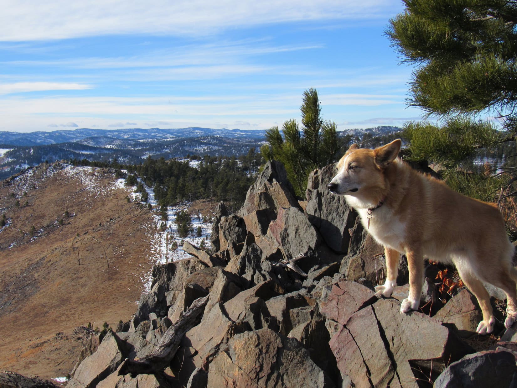
Cousin Mark atop Peak 5917. Mark is a Dance Dance Revolution champion who competes in tournaments. No wonder he was stepping so lively!Joe and Dusty join Mark at the summit. Photo looks N.Mark & Joe at the summit of Peak 5917. A triumph of sorts. They’re from Colorado. Maybe they’ve been on an even loftier peak once or twice before? Part of Pactola Reservoir (R) is in the background. Photo looks NNE.Lupe’s turn on the highest rocks while getting a pat from Mark. New Year’s Eve Peak is in view beyond her. Photo looks W.
December. Not especially cold, but definitely cool out. A chilly breeze was blowing out of the W. Prior to leaving Peak 5917, a group photo was hastily arranged.
L to R – Mark, Dusty, Lupe & Joe. Five Points(6,221 ft.) is a little L of Mark, and conical False North Point(6,130 ft.) is R of him. Pistol Point (5,880 ft.) is at the far end of the half grassy, half forested ridge on the R. Photo looks SW.
What now? Was everyone done? The closest options for extending the trek were New Year’s Eve Peak(6,046 ft.) a mile NW as the ridges went, go only halfway there to Pistol Point, or head SE back to Peak5800.
Pistol Point sounded good to everyone. Mark, Dusty and Joe started down Peak 5917’s SW slope. Loop lingered briefly at the summit before following after them.
Looper lingers in the chilly W breeze atop Peak 5917. New Year’s Eve Peak (L) in the distance. Lupe had been there only 5 days ago on Expedition No. 242. Photo looks NW.Mark, Dusty & Joe start down the SW slope. Black Elk Peak(7,231 ft.) (L), Five Points (Center) and False North Point (R) are all in sight. Photo looks SSW.Pistol Point is at the far end of the half grassy ridge on the L. Photo looks W.
Pistol Point is only 0.5 mile SW of Peak 5917. Cousin Mark was soon poised atop the rocky ridge.
Heading up to Pistol Point. Photo looks W.Mark poised atop the rock formations at Pistol Point while Joe takes a photo. Lupe is standing over near the rock resembling the handle of a pistol jammed into the ground that Pistol Point is named for. Photo looks ENE.Cousin Mark staying hydrated.Mark and Dusty relax for a moment taking in the views. Photo looks SE.Joe and Lupe take a turn up on the rocks. Photo looks W.
Pistol Point offers the same sweeping 180° views to the S that Peak 5917 does from only a slightly different perspective. The W wind was still chilly. If it hadn’t been for the breeze, New Year’s Eve Peak, only 0.5 mile NW, probably would have happened.
As it was, though, Cousin Dusty was shivering. At 12 years old, she was doing great to have come this far leading the way most of the time. Best to head back, though, to get her out of the cold wind.
Group photo at Pistol Point shortly before departure. Mark and Lupe on the L. Joe and Dusty on the R. Photo looks SW.Peak 5917 from Pistol Point. Photo looks NE.Joe and Dusty start down. Peak 5917 (L) and Peak 5800 (R). Photo looks ENE.
Dusty felt better as soon as she was out of the wind. The trek back to the G6 was scenic with great company to share the day with. The route back was the same, minus an excursion up to Peak 5917 again.
Dusty leads as Mark and Joe follow her down. Peak 5800 (R). Photo looks ENE.A momentary pause while Joe checks his phone. Part of Sheridan Lake is seen beyond Dusty.Calumet Ridge(5,601 ft.) is beyond the lake. Silver Mountain(5,405 ft.) is L of Calumet Ridge. Photo looks SE.Another pause on the return. Peak 5800 (Center). Photo looks ESE.Lupe in familiar territory. Nearly every year she makes a pilgrimage to New Year’s Eve Peak coming this way. Boulder Hill(5,331 ft.) (R) is the prominent knob far beyond her. Peak 5800 (L). Photo looks SE.Dusty having a good time in the Black Hills now that she’s out of the wind.Back on the road in the tall pines area. Photo looks E.
Before long, everyone was heading down the valley on snowy USFS Road No. 710. A ride back to Grandma’s house for goodies and more fun was waiting at the end of the road. Best of all, the festivities would continue for the next several days, because, you know, Christmas was coming! (12:52 PM, 29°F)
Mark, Joe, Dusty & Lupe on USFS Road No. 710, Black Hills of South Dakota 12-22-18
Lucky Dingo! Expedition No. 216 was going to have two parts. Mark and Hillary were in the Black Hills! Their time was limited, but they could spend a few hours hiking with Lupe and SPHP. Boulder Hill(5,331 ft.) would be a good destination. A trail goes all the way to the rocky top, and the summit offers some pretty nice views for moderate effort.
Loop and the gang arrived at the Boulder Hill trailhead of Flume Trail No. 50 before noon. Everyone hit the trail, heading SE through a Ponderosa pine forest which had been greatly thinned since the last time Lupe and SPHP were here. Only 0.33 mile from the trailhead, a saddle was reached between Boulder Hill and Storm Hill to the NE.
Beyond the saddle, a spur off Flume Trail No. 50 followed a dirt road S. The spur soon left the road, leading around the S side of Boulder Hill to the SW. Although Boulder Hill was only 0.5 mile S of the trailhead where Lupe had started, by the time she had circled around to the SW base of the rocky summit ridge, the Carolina Dog had already gone more than 0.75 mile.
The fun part of the climb was all that was left now! The trail leading up the ridge wound around among the rocks, passing near numerous viewpoints along the way.
Mark, Hillary & Lupe near the start of the short, but fun climb up the rocky ridge on top of Boulder Hill. Photo looks N.Lupe at one of the first vantage points. Photo looks NE.Hillary gazes toward Black Elk Peak(7,231 ft.) (L). Photo looks WSW.Hillary leading Mark on the way up. The trek to the top only takes 5-10 minutes. Photo looks S.
The trek to the top only took 5 or 10 minutes, plus a little time spent checking out views along the way. Although this was Lupe’s 6th ascent of Boulder Hill, Mark and Hillary had never been here before. They both seemed pretty happy with the interesting hike up, and the views available from the summit.
Of course, Lupe and SPHP never tire of seeing the world from a nice high point like Boulder Hill. Having Mark and Hillary’s company was a big added bonus!
Lupe, Hillary & Mark arrive at Boulder Hill’s summit. This was the first time Mark and Hillary had been here, but Lupe’s 6th ascent. Photo looks NW.Lupe was glad Mark & Hillary had taken the time to visit Boulder Hill with her. Their company was a rare treat! Photo looks NW.
Boulder Hill has two separate summit areas. They are practically right next to each other, and of about equal height. Naturally, Lupe, Mark, Hillary & SPHP visited both. It was only about 40°F and a chilly breeze was blowing, so the stay on top of the mountain was fairly brief. Soon everyone started down again.
Mark & Hillary start down. Photo looks NNW.
Lower down, on part of the ridge better protected from the breeze, everyone stopped to relax and have a longer look around. Mark & Hillary had brought sandwiches. SPHP had apples and chocolate chip cookies. Lupe had Taste of the Wild.
Surprisingly, it turned out that Lupe wasn’t the only Carolina Dog conducting tours of Boulder Hill today. Another Carolina Dog named Legos appeared! Legos was snappily dressed, and leading a man and a girl up the trail. In an odd coincidence, it turned out Mark and Hillary had met the man at a store only yesterday.
Lupe wasn’t the only Carolina Dog giving tours of Boulder Hill today! Snappily dressed in orange & gray, Legos appeared during break time. Legos was leading a man and a girl up the mountain.
Legos eventually led his party on up the trail. Mark and Hillary needed to get going, too. They had a social engagement this evening, and would return home to Colorado tomorrow. Except for the return trip to the trailhead, Lupe’s trip to Boulder Hill was over.
Lupe had enjoyed the outing, and SPHP really had fun visiting with Mark and Hillary. They’d had a good time, too, and felt Boulder Hill had been a great choice for the amount of time they’d had available.
The next morning the lucky Dingo was back in action, again! Things were back to normal. Just Loop and SPHP set out on Deerfield Trail No. 40 going up Rapid Creek from Silver City (10:13 AM, 41°F).
Lupe has been on this section of the Deerfield Trail many times. In fact, she first came here in January, 2012 on both Black Hills, SD Expeditions No. 1 & No. 2. In a sense, this was where her life of adventures began. SPHP had a new peakbagging destination in mind for her today, but the first part of the journey along Rapid Creek, was familiar territory.
On Deerfield Trail No. 40 near Silver City. This was familiar territory! Lupe’s first two Black Hills, SD expeditions way back in January, 2012 had been here.One of several fine footbridges across Rapid Creek upstream of Silver City.Loop on the bridge. Though there were quite a few footprints in the thin layer of snow, Lupe saw no one on or off the trail all day long.
Lupe had a great time exploring the forests alongside the trail. She was mainly looking for squirrels to bark at, and found a few, which made her very happy. Loop checked out the views along Rapid Creek, and visited an old abandoned horizontal mining shaft which she ventures into every time she comes this way. The shaft is only 20 or 25 feet long, but would make a great Dingo shelter in wet weather.
Going upstream from Silver City, Deerfield Trail No. 40 is never far from Rapid Creek, the largest stream in the entire Black Hills.Lupe at the entrance to the horizontal mining shaft. This mining shaft is only a few feet off Deerfield Trail No. 40, and makes a great Dingo cave!Looking out from near the end of the shaft.Continuing upstream on the trail.At another bridge over Rapid Creek.
Deerfield Trail No. 40 is a beautiful, easy trek along Rapid Creek. After she’d gone about 2 miles, though, Lupe was getting close to the Canyon City area where she would leave the trail.
Shortly after crossing yet another bridge, Lupe arrived at this bend in Rapid Creek. She was almost to Canyon City and would soon leave Deerfield Trail No. 40.This little swampy area comes just before Kelly Gulch close to Canyon City.
No town or much of anything else is at Canyon City these days. It’s only a spot along the trail, and a point on the map. About 0.25 mile before she got there, Lupe left Deerfield Trail No. 40 and Rapid Creek behind. She turned N following a path up Kelly Gulch.
Following the snowy path up Kelly Gulch. Photo looks N.
Kelly Gulch was the start of Lupe’s search for her peakbagging goal for the day, the summit of Tunnel Ridge(5,905 ft.). Loop wasn’t in Kelly Gulch very long, though. After only 0.2 mile, she came to a little parking area. Two roads left this point. The better road continued on up Kelly Gulch. Lupe took USFS Road No. 142.1D up Spurgeon Gulch instead.
On USFS Road No. 142.1D going up Spurgeon Gulch. Photo looks NNW.
Lupe had gained very little elevation down along Rapid Creek. She gained some coming up Kelly Gulch. Her climb really began in earnest, though, here in Spurgeon Gulch. The Carolina Dog gained elevation steadily now. She came to an unmarked intersection where a side road turned W, but she continued straight ahead. USFS Road No. 142.1D, if that’s what it still was, deteriorated and steepened.
Apparently USFS Road No. 142.1D sees little use these days. As Lupe followed it up Spurgeon Gulch, she came to places where the road was totally blocked by deadfall.
After going 0.75 mile up Spurgeon Gulch, Lupe arrived at a saddle in a small grassy open area where the road reached a “T” intersection. Some heavily forested hills could be seen from here. They weren’t far away, and the terrain seemed confusing. SPHP wasn’t certain which way Lupe should go.
Loop needed to work her way N, but straight N went down into another deep ravine. Staying on the roads, she had her choice of NE or W. The American Dingo tried the road going NE first. This road climbed gradually and seemed promising, but it soon turned R wrapping around a hillside until the position of the sun told SPHP that Loop was going S.
Lupe reaches the saddle at the upper end of Spurgeon Gulch. She had come up from the R. The road she’d been on came to a “T” intersection here. Photo looks NE along the branch Lupe explored first.
Going S wasn’t going to work at all. Lupe had a decent view of the hills nearby. It didn’t look like there was any way this road could turn N without losing a bunch of elevation.
The first road Lupe tried from the saddle went NE. It soon curled around a hillside and turned S leading to this view. This was definitely the wrong way. Photo looks SE.
Loop turned around and returned to the saddle. Time to try the road going W. Almost immediately, it angled NW and started gaining elevation steadily. Promising once again, but Lupe hadn’t gotten too far before she reached a bend where this road curved sharply around to the S, too. Hmm. What now?
At the bend, the ravine the road had been climbing continued NW. Lupe could see a stand of large brown-barked Ponderosa pines on a slope below rock outcroppings. Why not keep going that way? It seemed like the best option. Lupe left the road, continuing NW up the ravine.
Lupe among the large brown-barked Ponderosa pines after leaving the road. Photo looks N.
Loop only had to follow the ravine a little way before she appeared to be approaching the upper end of it. She turned N, scrambling up between the rock formations to reach a small ridge. On the other side, not very far below her, Loop saw another road heading NW. That was promising! Lupe worked her way down to the road and followed it.
Loopster was still gaining elevation, though more slowly than before. Eventually this new road joined another one heading NNW, exactly the direction Lupe needed to go.
Lupe at the intersection with another road that went NNW. She had come up the road seen on the L. NNW is toward the camera, and just the direction Loop needed to go. Photo looks SSE.
The road leading NNW gained only a little more elevation before topping out. The terrain ahead was now mostly flat to rolling. Lupe had succeeded in reaching the top of Tunnel Ridge, but exactly what part of it wasn’t clear yet.
Tunnel Ridge(5,905 ft.) is roughly 3 miles long N/S, and as much as 0.50 to 0.75 mile wide E/W. It was all forested, so it was hard to see very far ahead. There didn’t seem to be any definite ridge line to follow. Loop was probably only 0.33 to 0.50 of the way from the S end. The true summit was near the N end, which meant it was probably 1.5 to 2 miles N of Lupe’s position.
The road eventually bent NW and started going downhill. By now, Lupe had seen occasional glimpses of higher ground perhaps a mile or more to the NNW. Trying not to lose elevation, Lupe left the road traveling N through a level forest, hoping this area would connect somehow with the higher ground she’d seen in the distance.
Somewhere up on Tunnel Ridge, Lupe left the road to head N through this forest looking for the summit. This proved to be a dead end. Photo looks N.
Instead, Loop eventually found that the terrain dropped off rather steeply. This was a dead end. She had to return to the road. This happened once more, a little farther on. The road went NW downhill again, and Lupe made another foray off the road. She climbed N toward a high point, but on the other side, the terrain dropped steeply.
From the high point, Lupe went NW down a long slope, rejoining the road again at a gate near a saddle. At the saddle was a “T” intersection with another road passing E/W over the mountain. No road continued N from here, but the land sloped up, so Lupe left the road a third time.
Continuing N off road for the 3rd time. Photo looks NNW.
Lupe was only partway up when she saw the high point to the N again. She was definitely getting closer.
As Lupe continued her climb, the higher ground she had seen a while ago came back into view. She was definitely getting closer! Photo looks N.
By now, SPHP was confident Lupe was closing in on the summit of Tunnel Ridge. The topo map showed 4 separate areas enclosed within 5,880 foot contours. The central contour enclosing the most area contained a site elevation of 5,905 feet, which was likely the true summit. On the way there, Lupe explored the SW 5,880 foot contour, which contained the 2nd largest amount of territory.
The terrain within the SW 5,880 foot contour was pretty flat, but Lupe found a spot with a view toward Black Elk Peak(7,231 ft.).
Lupe at the high point of the 5,880 foot contour SW of the true summit. This was pretty flat territory! Photo looks W.A glimpse toward Black Elk Peak (R on horizon) from the SW 5,880 foot contour. Photo looks SSE with help from the telephoto lens.
From the SW high point, Lupe headed for the true summit. As she got close, she reached yet another unmarked road.
Approaching the true summit, Lupe came to this road. Photo looks NNE.
A short trek on this latest road led Lupe gradually up to a flat area which had to be the true summit. No views, really. The summit of Tunnel Ridge(5,905 ft.) was just another slightly higher spot in the woods.
Success! Loop at the true summit of Tunnel Ridge. Photo looks E.About all there was for a view from the top of Tunnel Ridge was this tree-broken glimpse of a distant ridge to the S.
Partly to check out another small area enclosed within a 5,880 ft. contour, and partly just to see what was there, Lupe left the true summit to explore a broad ridge to the SE. Loop went all the way to the end. The terrain was all lower than where she’d just been.
At the end of the ridge SE of the summit. Photo looks SE.
There wasn’t anything much different to see on the SE ridge, so Lupe returned to the true summit. On the way, she posed on a mighty, massive rock outcropping.
Oh, OK, so it wasn’t a mighty, massive rock outcropping – just a minor one. Lupe still looked pretty good on it!
It was only mid-afternoon, but the sun was already low in the sky. The G6 was 5+ miles away. Loop needed to get going. There wasn’t much reason to hang around the summit, anyway. On the way back, Lupe retraced virtually the exact same route she’d taken to Tunnel Ridge, minus some of the unnecessary forays that led to dead ends in the forest.
Starting back, still close to the summit.At the saddle where a road goes E/W across the mountain. All the roads Lupe came to on Tunnel Ridge were unmarked. The one leading back to Spurgeon Gulch is seen beyond Looper. Photo looks SW.
Looper’s journey to Tunnel Ridge had been a peakbagging success. She’d made it up onto the ridge and found the true summit. Of course, other than the pretty spots down along Rapid Creek, she hadn’t really come to much in the way of views. Due to the forest, Tunnel Ridge didn’t have much to offer in the way of scenic rewards.
A rare distant view on the return trip. Photo looks SE.
Yet the journey to Tunnel Ridge had been a good day. The maze of unmarked roads and promising routes that led nowhere had been confusing, but solving the puzzle was a fun challenge. Lupe and SPHP enjoyed unbroken peace and solitude from start to finish. And now a previously unknown part of the map was at least partially explored.
Just being on the move, exploring and sharing this cool day outdoors in the pine forest, made Lupe’s journey to Tunnel Ridge another adventure worth remembering (5:14 PM, 35°F).