Day 15 of Lupe’s 1st Summer of 2021 Dingo Vacation to New Mexico!
5-22-21, 6:42 AM, 40ºF, Jemez Mountains, New Mexico –
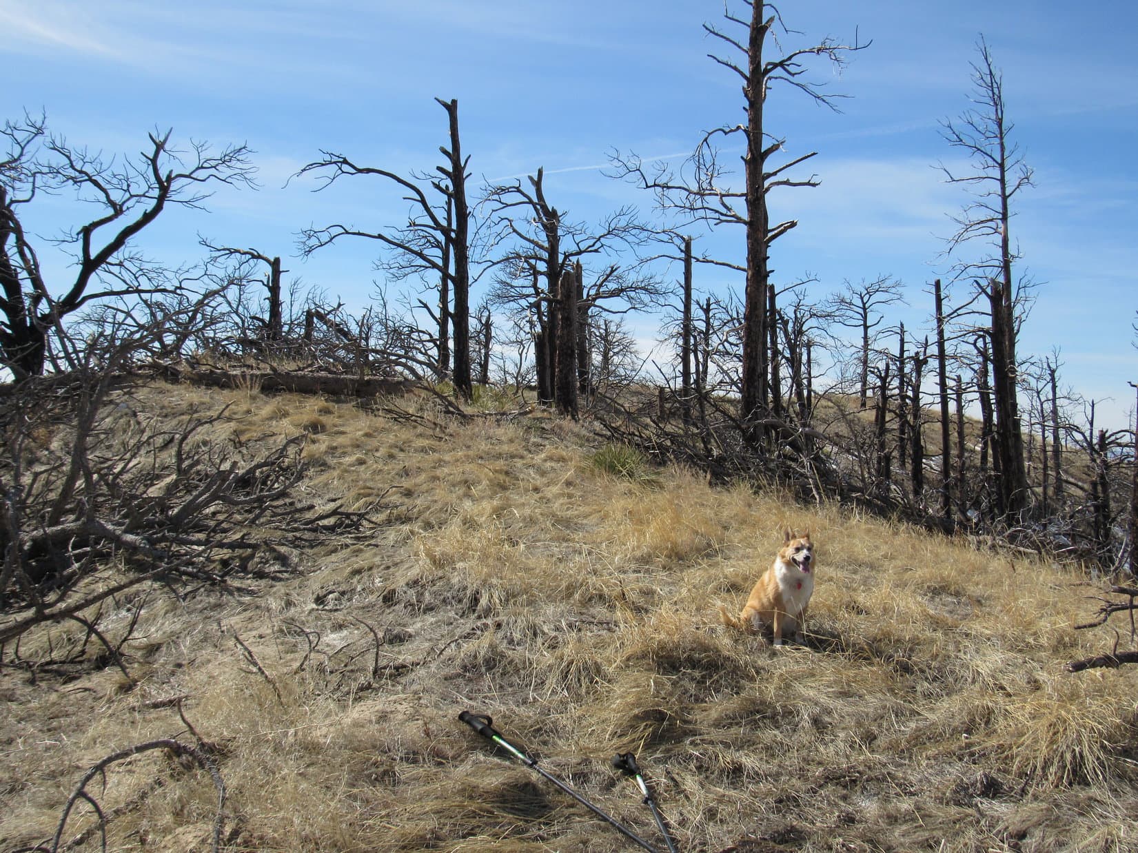
We’re turning around, SPHP?
Yup. Sorry, Loopster! It’s not happening.
The RAV4 had made it a few miles W of the pass along USFS Road No. 144 where Lupe had started for Polvadera Peak(11,232 ft.) yesterday, but directly ahead was a stretch of very rough road. The intention had been to start the day with an ascent of Cerro de la Garita(10,600 ft.), but it was still miles away, and Lupe’s RAV4 was practically brand new! SPHP wasn’t about to abuse it like this.
So Cerro de la Garita was out. Morning sun shining directly into SPHP’s eyes, the scenic drive back E to Espanola began.
Turned out, not much else was going to happen on this Dingo Vacation, either. It was time to start for home, and farther N the peaks on Lupe’s list of possibilities for this trip were all too high, still blanketed in snow. It was a gorgeous drive, though, through some parts of New Mexico and Colorado Lupe had never been to before. For hundreds of miles, the Carolina Dog was content riding in comfort on her pink blanket while enjoying all the fabulous scenery. Cows, horses, sometimes even sheep!
Now and then SPHP stopped to let the American Dingo get out to stretch and sniff the air for a few minutes, but SPHP seemed to have a different sense of what the journey’s highlights were.
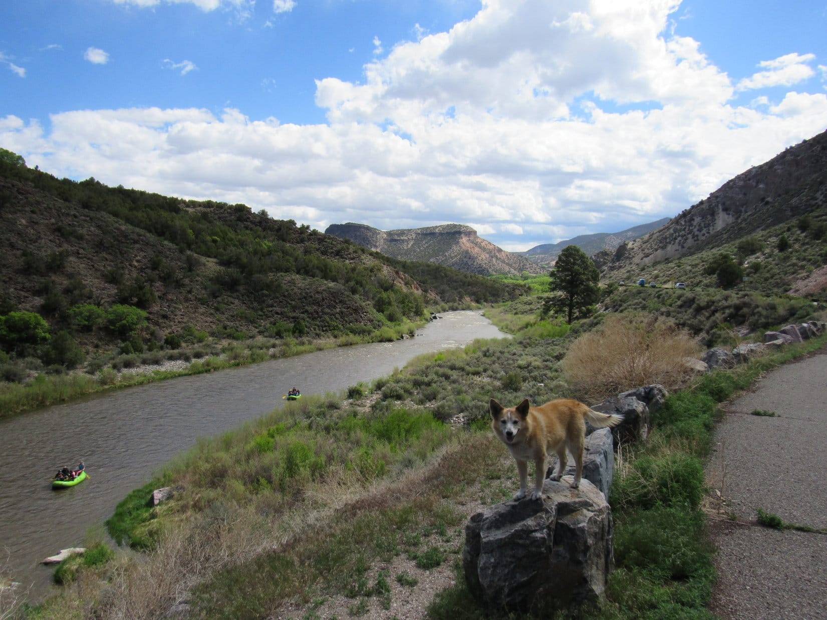
Rio Grande River from Hwy 68, S of Taos, New Mexico.Blanca Peak(14,345 ft.) (L) from Hwy 160, NE of Fort Garland, Colorado.
In Colorado, everything was green E of the Rockies. Clouds hung low over the prairie, hiding the mountains, as heavy showers drifted slowly E. Once SPHP turned N onto I-25, the interesting part of the drive was over as far as Loopster was concerned. Nothing but traffic. Nap time!
A long nap it was, too. SPHP thought about taking Hwy 24 NE out of Colorado Springs, then turning N on Hwy 71 way out on the prairie, but didn’t do it, a decision soon regretted as rain, construction, and accidents made a stop and go mess of I-25 all the way to Denver and beyond.
After fueling the RAV4 at Exit 269 near Fort Collins, instead of returning to I-25, SPHP drove E on Hwy 14 toward Briggsdale. Lupe yawned.
Finally wised up and getting us out of all the horrendous traffic, SPHP?
Yes, wised up in more ways than one, actually.
What do you mean, SPHP?
Rather late as far as ditching the traffic goes, since we were already past the worst of it, but I happened to think about one more thing we ought do on this Dingo Vacation.
And what might that be?
How would you like to see some buffalo, Looper?
You know I’d love that, SPHP!
Well, if we can get there before it gets dark, you might get to see some.
Get where before dark?
Panorama Point(5,429 ft.), Loop! Highpoint of the state of Nebraska! It’s at the far SW corner of the Nebraska panhandle on a buffalo ranch.
That sounds great, SPHP! Drive a little faster, would you? Don’t want to miss out on the buffalo!
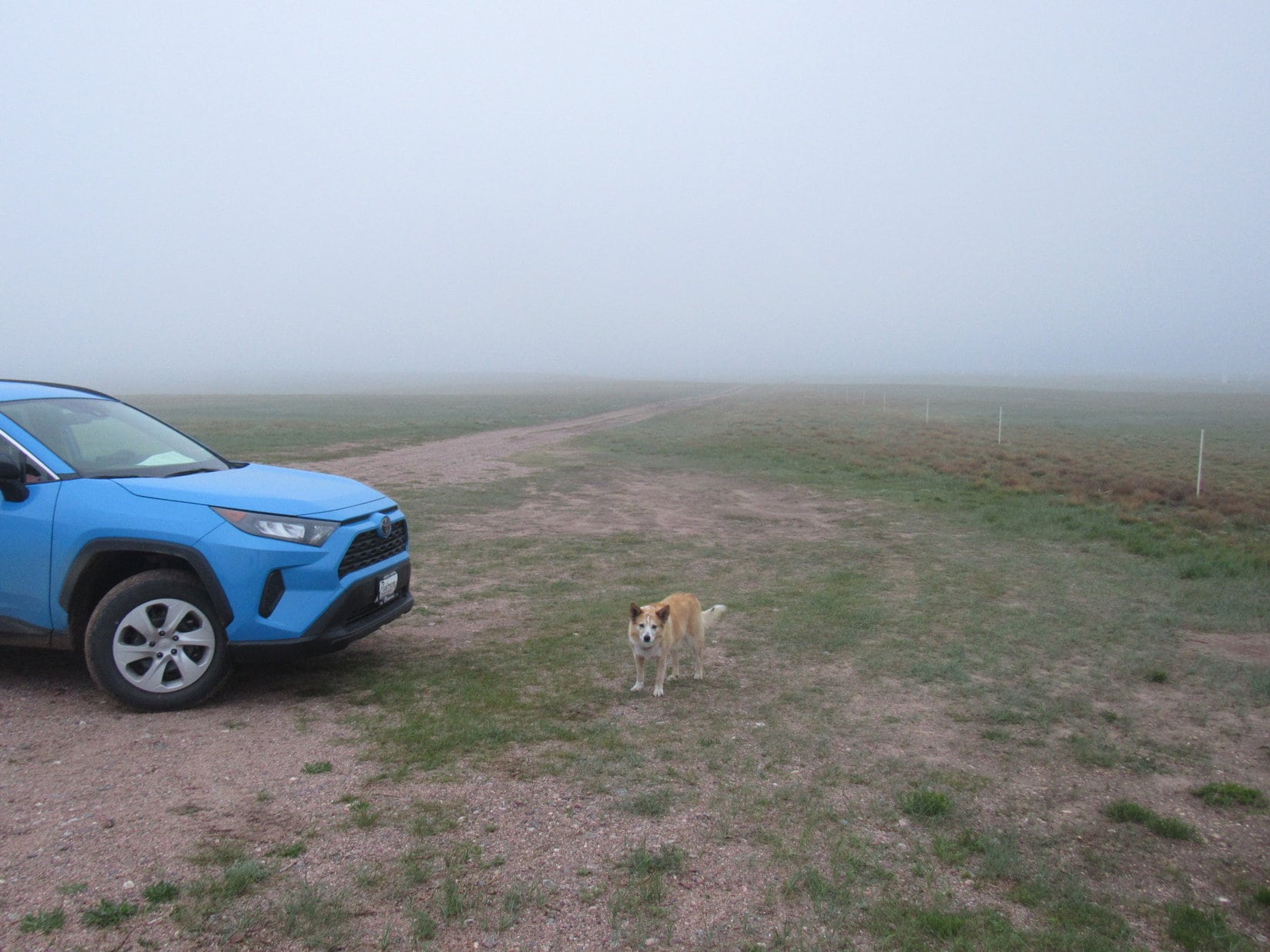
5-22-21, 8:00 PM, 53ºF, Nebraska state line – Of all the rotten luck! Poor Loop wasn’t going to get to see much of anything at Panorama Point, even though the evening light hadn’t completely faded away yet. 20 miles from Panorama Point, SPHP had driven into dense fog.
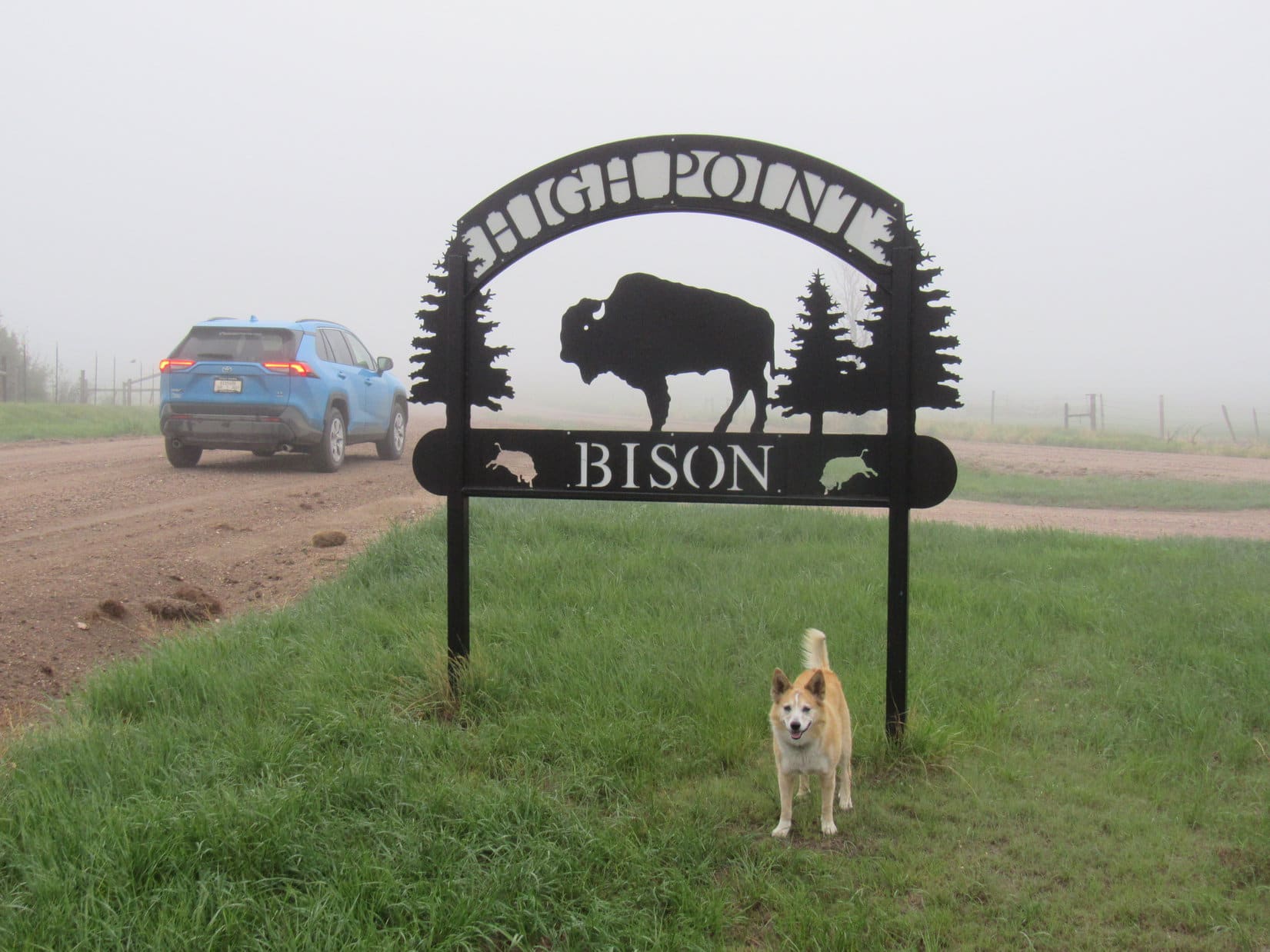
Standing cheerfully in a raw 20-25 mph E wind next to a big sign at the Nebraska state line, Lupe didn’t seem to realize what that meant yet. By the looks of the big grin on her face, the excited Carolina Dog was still eagerly anticipating all those glorious buffalo spread out across the Nebraska plains, a notion the sign greatly reinforced.
At the High Point Bison sign just inside the Nebraska state line.
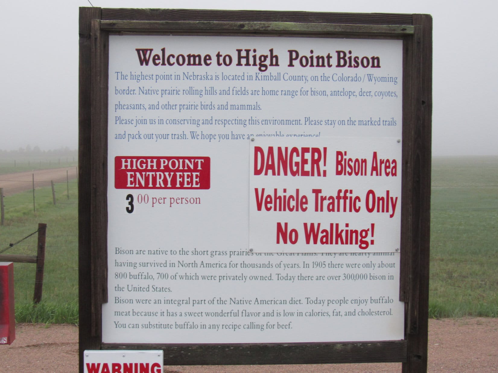
Apparently High Point Bison is the name preferred by the owners of the ranch where Panorama Point is located. Lupe thought it a marvelous name! 0.1 mile N of the High Point Bison sign, SPHP turned L (W) off County Road No. 203. Another sign at the turn explained the rules for public access. Basically a $3.00 per person fee, and no messing around with the buffalo – vehicle access only, no hiking or biking in.
The pay station was out of envelopes, so SPHP just wrote a check and slid it into the red metal drop box.
At the entrance to High Point Bison, aka Panorama Point. Photo looks S.Public access rules set by the landowners.
After paying the fee, there was no gate to open or close entering the ranch, only a cattle guard to drive over, a rather nice convenience on such a blustery, damp evening. Panorama Point was a little over a mile farther W. Sadly, the fog was so thick only the pasture next to the dirt road could be seen during the drive in.
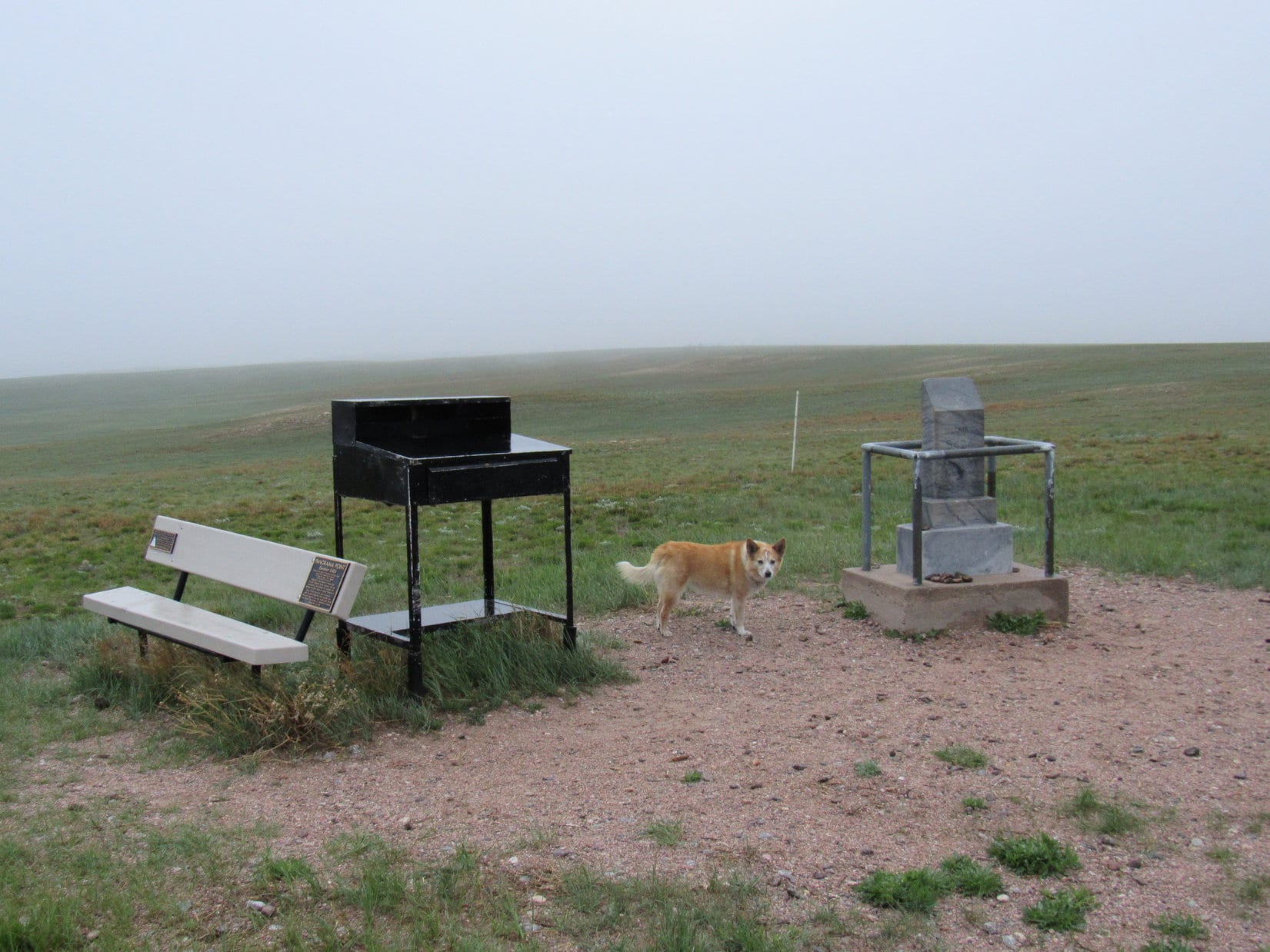
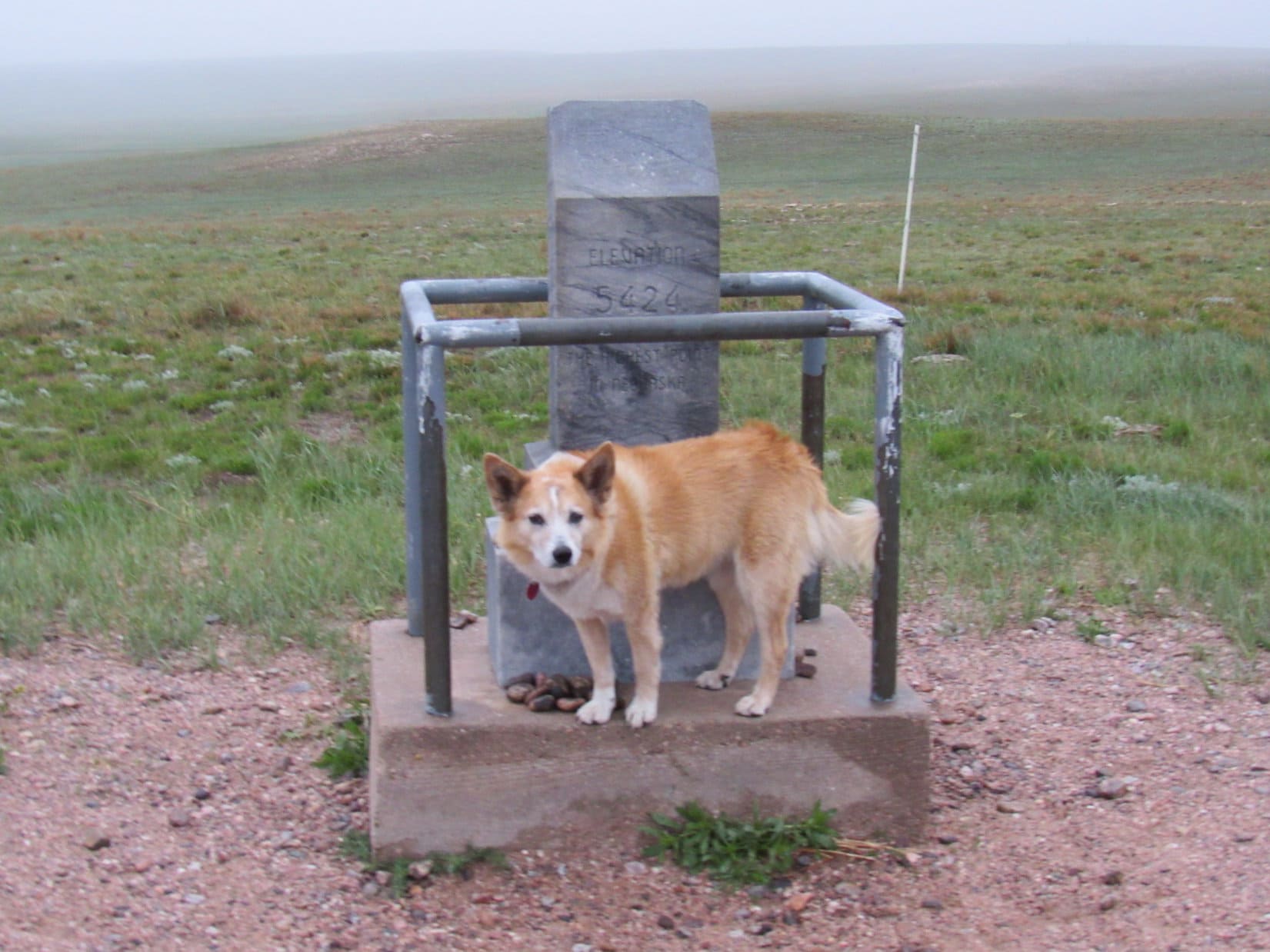
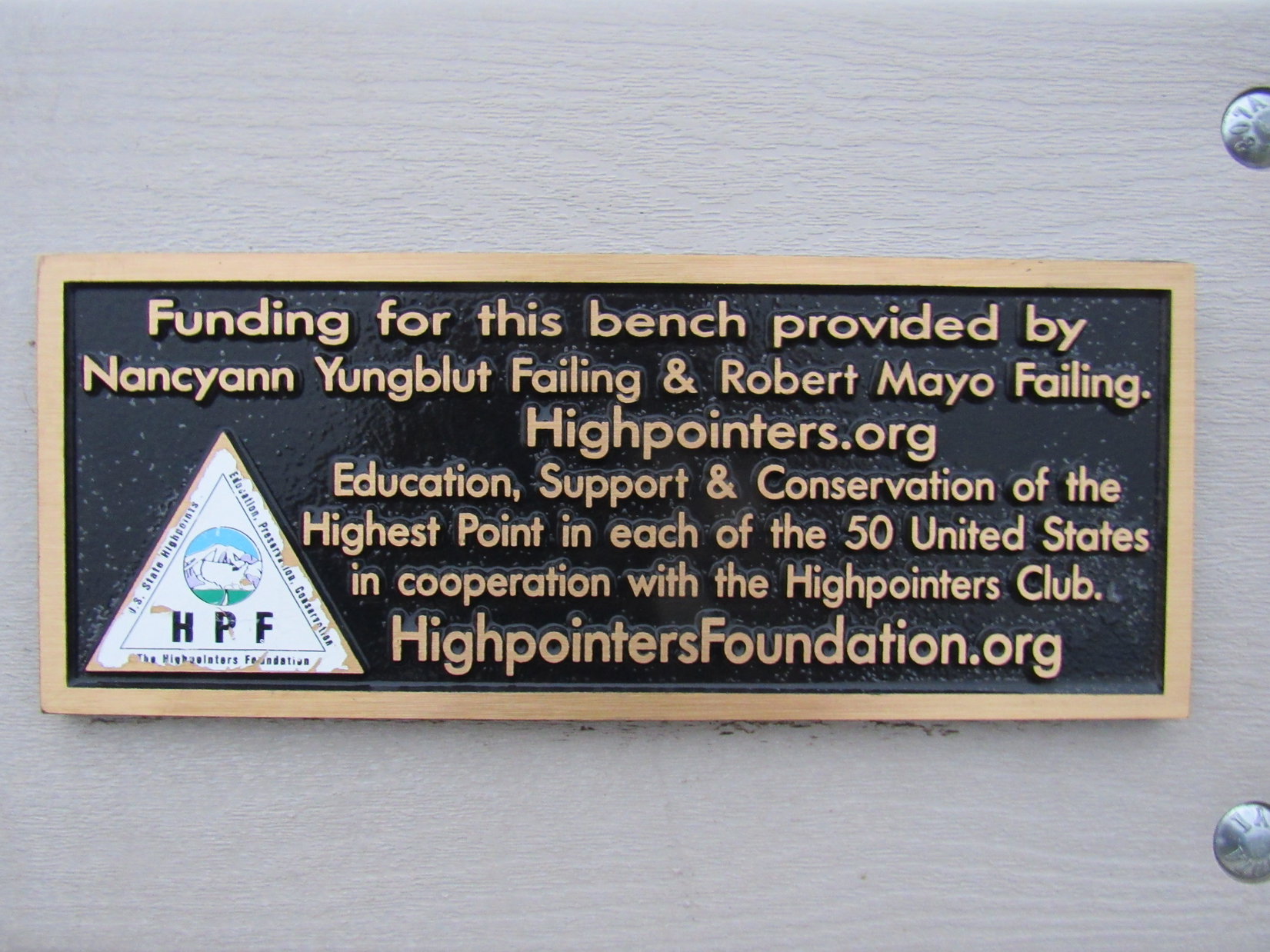
Near the end, the access road curved NW. Lupe was soon standing in fog, light rain, and the chill E wind at Nebraska’s remote state high point, which featured a small monument, a black desk, and a handsome bench placed by the HighpointersFoundation.org.
At Panorama Point, Nebraska, Lupe’s 5th state high point. Photo looks NW.
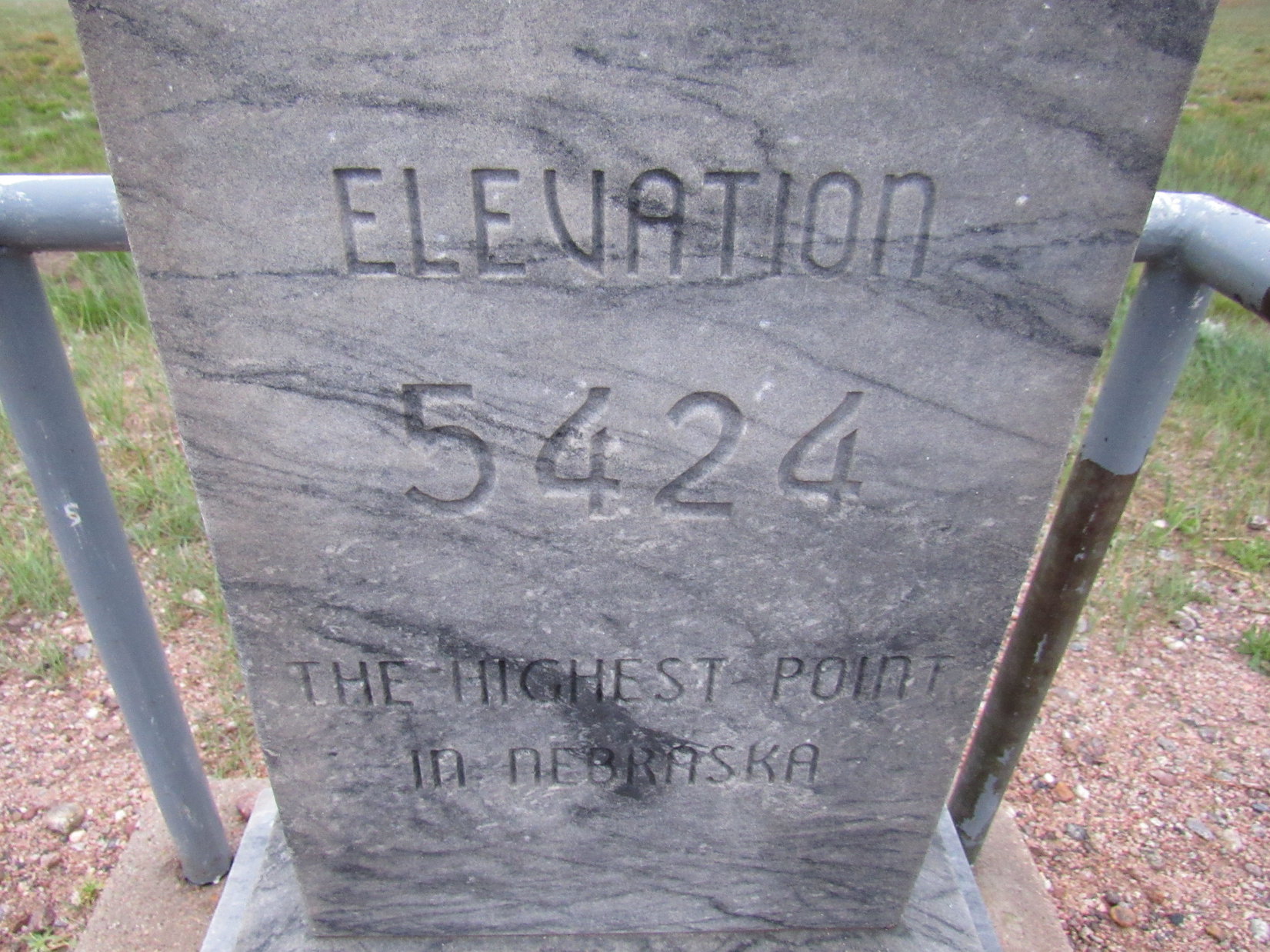
Of course, the first thing to do was to check out the stone monument.
By the monument marking Nebraska’s state high point. Photo looks NW.The monument inscription.
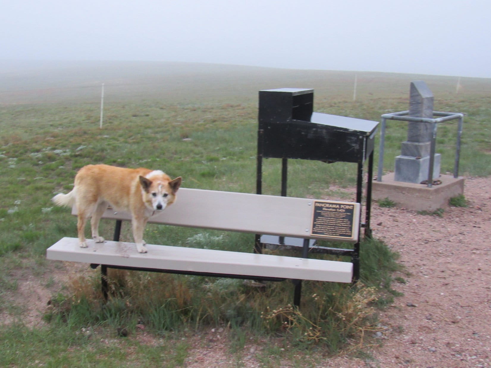
Next, Lupe went over to have a look at the world from the Highpointers bench.
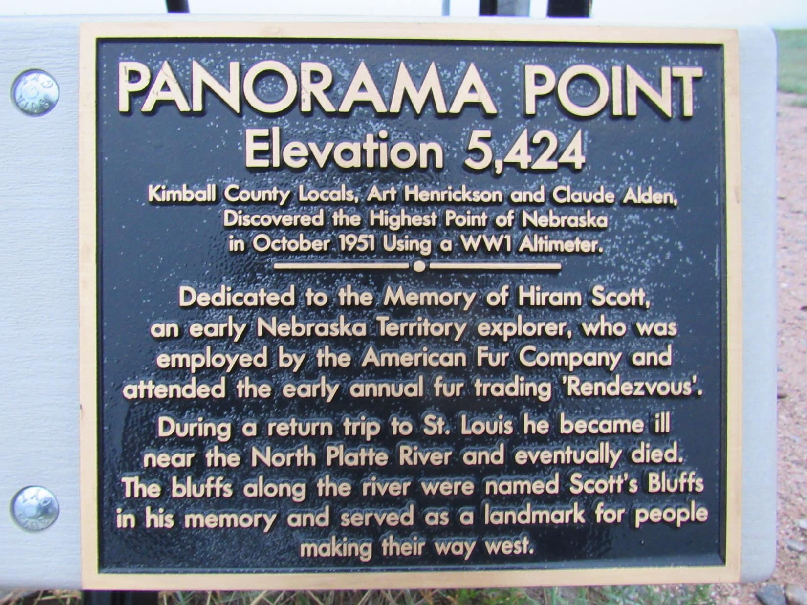
Standing on the Highpointers bench, since it was rather wet for sitting on.History-related plaque attached to the bench.
The world, at least this little chunk of it, looked foggy and damp, and was sorely lacking in the promised buffalo Lupe had come to see.
Come on, Looper, let’s go!
What? Wait a minute, SPHP! Where are all the buffalo? I don’t see any!
I know it, but that’s the way it goes, Loop. They’re probably somewhere out there in the fog, but we can’t stray too far from the RAV4 looking for them. Not allowed. Not to mention that it would be pretty easy to get lost. Wouldn’t be a very fun night outdoors, either, that’s for sure.
But this is a state high point, and we just got here! Aren’t you even going to sign us in at the registry? It must be in that black desk, don’t you think?
Yeah, probably, but no! Forget that! Not going to stand here in the cold wind and miserable rain any longer. Maybe we can come back sometime on a nicer day to sign in and see the buffalo?
SPHP wasn’t going to give in. Reluctantly, Lupe hopped back into the RAV4.
About to leave lovely Panorama Point. Photo looks SE.
Will you at least promise me we really will come back to see the buffalo some day, SPHP?
Yes, I suppose so. Sorry to have disappointed you this evening, Lupe. Just bad luck. You really will get to see them someday. I promise.
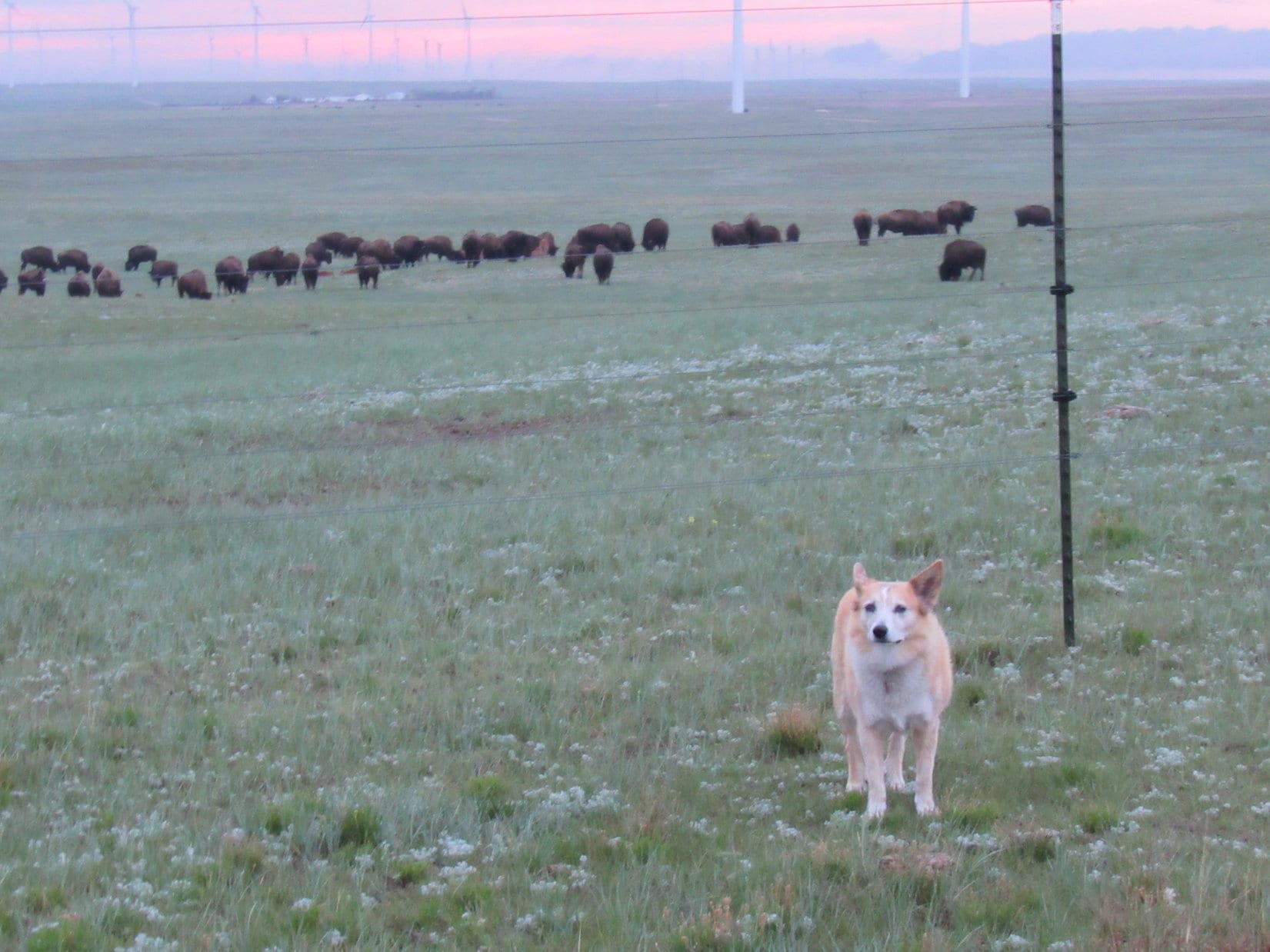
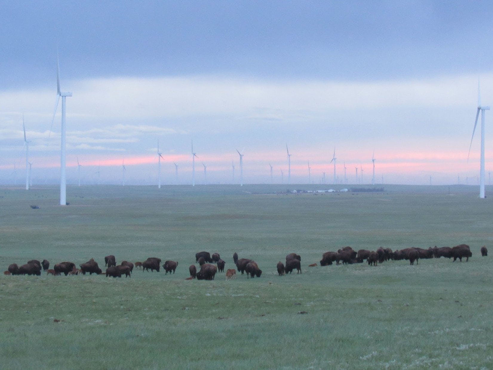
And then, on the short drive out, a minor miracle occurred. Suddenly, the last of the ground fog streamed by and the rain ended. A strong cold wind still blew out of the E, but it was now possible to see. Just S of the road there was a fence. In the evening gloam beyond the fence there was a big wind farm in the distance. Something else was out there, too.
SPHP! Stop! Stop! There they are! The buffaloes!
Out to see the buffaloes near Panorama Point.
Like magic, promise kept. And at the end of a wonderful Dingo Vacation, yet another Dingo dream come true!
Near Panorama Point, Nebraska’s state high point, 5-22-21.
Not much of an artist are you, SPHP? Can’t even draw a decent stick Dingo!
True, that! But it’s not a stick, Dingo. It’s a topographic map. With all of two contours on it. It’s going to have to do.
We’re going to rely on that?
Yeppers. Can’t waste any more time trying to print out a decent map. No telling where we might wind up with this wonderful homemade navigation tool, but we’ve got to get going.
Why can’t you print out a map? Is the printer broken?
No, I don’t think so. The computer and the printer are just having a spat. They’re refusing to talk to each other. Probably angry and upset by something one of these automatic Windows 10 updates said. I see that the printer got all huffy and “migrated” on 3-9-18. I never told it to do that, and it never asked for permission. It just took off on its own free artificial intelligence.
Migrated? Are you blind, SPHP? The printer is right there, still on your desk. It never goes anywhere.
Oh, you would be surprised, Looper. It migrates digitally. In this case, off to Noprintyland again, where it loves to wander off to every chance it gets.
So even though the printer is still right here, you’re saying it’s off having adventures of its own in Noprintyland?
Sounds strange, but yeah, that’s about the size of it.
Doesn’t make a lick of sense to me! Are you feeling, OK?
Yes, I’m fine. Anyway, come on! Time to hit the road!
Due to colder than normal wintry weather, Lupe hadn’t really been much of anywhere for a whole month. The snow had been melting the last couple of days, though, and today was supposed to be really nice. Loopster was ready for action – had been for weeks, but SPHP just kept driving. The American Dingo had a fun time barking at cows, but was still glad when SPHP finally parked the G6.
Lupe hopped out. She was at a familiar place, Cascade Falls along Hwy 71 at the S end of the Black Hills. Although Cascade Falls is a popular swimming and wading spot in the summer, no one was here now.
Let’s go take a look at the falls, Looper.
Lupe was happy to see Cascade Falls again. Photo looks WNW.Loop by Cascade Creek with Devil’s Slide Mountain(3,965 ft.) in the background. Photo looks NE.So are we gonna have a picnic, SPHP?
Lupe would have been perfectly happy staying at Cascade Falls, but that wasn’t her destination today. She was just here to stretch her legs for a few minutes, then it was back in the G. The drive S continued.
Nebraska! That sign said Nebraska! Are we going to cousin Dusty’s house in Colorado, SPHP? You sure packed light this time.
No, we aren’t going all the way to Colorado, Looper. We’re going back to Toadstool Geologic Park to explore part of the Hudson Meng Bison Trail. Remember when you took the Fossil Loop Trail a couple of years ago? That was in Toadstool Geologic Park.
Oh, yeah! That was awesome exploring the Nebraska badlands! Had to watch out for cactus, though. So we’re going back to take the Bison Trail now? Will we get to see the Hudson Meng Bison Kill? Oh, I hope so! Just think of it, SPHP, the bones of 600 bison, just laying there waiting to be gnawed on! Why, I will be the richest Dingo on earth with a treasure like that!
No, we’re not going all the way to Hudson Meng. Sorry. I don’t think it’s open this time of year. They wouldn’t let you chew on their bison bones, anyway. You wouldn’t like it if they did. Those bones are 10,000 year old fossils now. You’re a bit late getting to them.
Oh, too bad. So what are we gonna do then?
We’re going to take the Hudson Meng Bison Trail up the Big Cottonwood Creek drainage. When we’re out of the badlands, we’ll leave the trail and head S for Roundtop Peak. I’m hoping we’ll get to Pine Butte and Wright Peak, too. You will get to do a lot of exploring.
Oh, some peakbagging! Sounds like fun. Not as much fun as 600 bison bones, though.
Almost immediately after crossing the Nebraska state line, SPHP turned R on Toadstool Road. Toadstool Road was gravel. For a few miles there were spots where the road was mighty wet. The G6 went through huge mud puddles sending a slushy, muddy spray everywhere, but fortunately did not become stuck. The road then improved somewhat, up on higher, drier ground.
12 miles from the N end of Toadstool Road, Lupe saw another sign for Toadstool Geologic Park. SPHP turned R (SW) onto a side road that went up over railroad tracks. Toadstool Geologic Park was only 1.5 miles from here, but SPHP stopped a little before Lupe got there. Her peakbagging objectives for the day were in view.
Lupe arrives in NW Nebraska for some peakbagging fun. Roundtop Peak (far L), Pine Butte (L) and Wright Peak (far R) are all in view. Photo looks SW.Roundtop Peak(4,540 ft.) (L) and Pine Butte(4,500 ft.) (R) with a little help from the telephoto lens.Zoomed in on Roundtop Peak.
The road dead ended at a campground. Toadstool Geologic Park was totally deserted when Lupe arrived. SPHP took a quick look at some of the displays, while Lupe sniffed around the campground.
Lupe arrives at Toadstool Geologic Park in remote NW Nebraska.The Toadstool Geologic Park campground is on flat ground on the E edge of fossil bearing badlands. Photo looks SW.One of half a dozen informational displays. Fossils in the park are from the Eocene and Oligocene epochs during the “Golden Age of Mammals”.A display about the geological history of the area.This display is about exploring Toadstool Geologic Park. A 1 mile long Fossil Loop Trail goes through the badlands of Toadstool Geologic Park. Lupe had done the whole loop back in April, 2016. Easy and worthwhile!
After brief preparations, Lupe and SPHP left the campground heading W on the Fossil Loop Trail. (10:29 AM, 53°F) Lupe was soon among the toadstool rock formations Toadstool Geologic Park is named for.
Lupe among the toadstool formations along the Fossil Loop Trail. Photo looks NW.
The Fossil Loop Trail wound among fascinating badlands scenery. Lupe quickly reached a junction with the Hudson Meng Bison Trail.
After an interesting short trek along the Fossil Loop Trail, the junction with the Hudson Meng Bison Trail comes into view beyond Big Cottonwood Creek. Photo looks SW.The Fossil Loop Trail goes L, while the Hudson Meng Bison Trail goes R.Loopster ready to head out on the Hudson Meng Bison Trail. Photo looks W.
The Hudson Meng Bison Trail follows Big Cottonwood Creek S for more than a mile. Big Cottonwood Creek didn’t have any cottonwoods along it, so there wasn’t much shade. Most of the year, the creek would have been dry, but there was a shallow stream of snow melt today.
The trail crossed the creek many times. If conditions had been much wetter, this would have meant numerous slogs through deep mud. Clearly this was no place to be when it was wet. Fortunately, it was just dry enough today so SPHP could avoid getting too terribly muddy. Lupe simply forged ahead oblivious to the creek crossings.
Loop hadn’t gone far when she came to a sign saying she was about to leave Toadstool Geologic Park.
The Hudson Meng Bison Trail soon leaves Toadstool Geologic Park entering the Oglala National Grassland. Photo looks S.
The Hudson Meng Bison Trail promptly faded away. Apparently it sees little use. There was seldom any track to follow, but brown posts topped with beige marked the general route.
As Lupe followed Big Cottonwood Creek upstream, it became little more than a trickle. It wasn’t always possible to tell at a glance which way the Hudson Meng Bison Trail went. Other little creeks trickled out of large side canyons and ravines.
The marker posts weren’t numerous, but if Lupe went more than 5 or 10 minutes without seeing one, she had usually taken a wrong turn into a side canyon and had to backtrack. The correct route was almost always toward the W (R) in the canyon with the most vegetation.
Some of the side canyons proved to be interesting detours. Even if they were the wrong way, Lupe had fun on her brief excursions into them.
Loopster checks out the view from the top of a rock wall overlooking Big Cottonwood Creek. Photo looks WNW.Oh, SPHP, I just had a thought. Do you think we will come to any live bison along the Hudson Meng Bison Trail? Maybe I can get a fresh bison bone yet! Don’t see any bison from up here, but keep an eye out, would ya?Lupe in a scenic side canyon that proved to be the wrong way. Photo looks SE.Back on the trail. A brown marker post topped with beige is seen beyond Loop. Staying toward the W (R) in the canyon with the most grass was usually the correct way to go. Photo looks SSW.
Only a few days ago, it had still been cold out. With some snow still melting, SPHP wasn’t too worried Lupe would run into rattlesnakes.
However, there was a fair amount of her other prairie nemesis around. Cactus wasn’t super abundant, but it wasn’t uncommon either. SPHP had to watch out for it for Looper. In a few places, SPHP carried Lupe beyond larger cactus patches. Every now and then she stepped on a cactus, and didn’t care for that at all. SPHP then had to pull a few small, but painful spines out of her paws.
For the most part, though, the Carolina Dog was doing fine. She was having a good time sniffing and exploring. The badlands scenery following Big Cottonwood Creek was so beautiful and western looking! It was fun to think about all the strange ancient mammals that used to roam this area millions of years ago. Some of their bones are still hidden as fossils back in these wild looking ravines.
Another little stream trickles out of a wild badlands side canyon. Photo looks ESE.That’s kind of an interesting rock up ahead, don’t you think, SPHP? …. Oh, yeah! Pretty cool, Looper, looks like its the right direction, too! Not a bad landmark. Photo looks S.
After crossing muddy Big Cottonwood Creek a zillion times, and dodging cactus patches which were becoming more frequent and extensive, Lupe arrived at a fence. The fence had a big open gap in it where what little remained of Big Cottonwood Creek flowed through. Beyond this gap a trail marker could be seen. For the first time, the trail left the creek’s main channel here and entered a narrow side canyon.
At this fence line, Lupe reaches the end of her trek along Big Cottonwood Creek. A trail marker seen beyond the fence directed Loop into a narrow side canyon on the R.
The side canyon was V-shaped with steep, crumbly sides. The upper rim of this ravine wasn’t all that much higher than where Lupe was at the bottom. Clearly, the American Dingo would soon be reaching the end of the canyon.
Looper going up the narrow side canyon. The sides were steep and crumbly, but she would soon reach the end of this ravine. Photo looks S.
The end of the ravine was steep, but a short climb brought Lupe up onto a vast prairie. A faint, grassy road headed SSE. This was USFS Road No. 918, which would eventually go over a saddle between Roundtop Peak (4,540 ft.) and Pine Butte (4,500 ft.), both now back in view to the S.
Lupe emerged from the Big Cottonwood Creek drainage system up on a vast prairie. Roundtop Peak (L) and Pine Butte (R) were both back in view again. Photo looks S.
A line of Hudson Meng Bison Trail markers led across the prairie heading SW toward another big ravine. This ravine is part of the Whitehead Creek drainage. Following USFS Road No. 918 would have been a little shorter, but Lupe stuck with the Hudson Meng Bison Trail until she got close to the Whitehead Creek ravine instead.
Lupe nears the Whitehead Creek drainage. She left the Hudson Meng Bison Trail here. The trail continues down into the ravine and up the other side on its way to the Hudson Meng Bison Kill. Wright Peak(4,654 ft.) is in view at Center. Photo looks SW.
Instead of following the Bison Trail down into the Whitehead Creek drainage, Lupe left the trail heading SE. She stayed on the high ground overlooking the scenic ravine. The rim of the ravine had only a little grass and virtually no cactus. Lupe gained elevation steadily.
0.75 mile from where she’d left the trail, Lupe neared the top of a small hill. Here she had a good view off to the SW from a different angle than before. A higher ridge could now be seen beyond a sharp hill that SPHP had assumed was Wright Peak. Maybe that higher ridge was actually Wright Peak(4,654 ft.)? SPHP wasn’t certain. It seemed like that might make sense.
Consulting the hand-sketched topo map didn’t help. Knowing that Lupe would ultimately be approaching Wright Peak from the E, SPHP hadn’t extended the map any farther W than Wright Peak. Whether or not there was any higher ground beyond it wasn’t shown.
Nothing could be done to extend the map now. Lupe continued up to the top of the small hill. Roundtop Peak was less than 0.5 mile S.
Lupe on her way up the E edge of the Whitehead Creek drainage. This was a more scenic route than simply following USFS Road No. 918 would have been. Roundtop Peak is at Center. Photo looks SSE.Nearing the top of a grassy hill, Lupe has a good view to the WSW. Up until this point, SPHP had assumed that the sharp hill on the R was Wright Peak. However, Lupe could now see a higher ridge beyond it on the L.Looper reaches the top of the grassy hill. Her first peakbagging destination, Roundtop Peak is only 0.5 mile away. Photo looks S.
Lupe ended up following USFS Road No. 918 part of the way to the base of Roundtop Peak. She left the road to climb the hill’s surprisingly steep N slope.
A forest fire had occurred in this region in 2012. Most of the pine trees on Roundtop were dead. Quite a few had fallen over. The deadfall made getting to the summit of Roundtop Peak harder than it should have been, but it still didn’t take Loop long to reach the top of the hill.
First things first! Lupe was ready for a break. Water and Taste of the Wild. SPHP ate an apple. For a little while, Loop and SPHP rested with a grand view of the western Nebraska prairie off to the SE. Then it was time to tour Roundtop’s summit.
Loopster takes a break up on Roundtop Peak. Photo looks WNW.Lupe enjoyed a grand view of western Nebraska prairies and ridges from Roundtop Peak. She could see Sand Creek Road, which is on the way to the Hudson Meng Buffalo Kill by vehicle. Photo looks SE.Loop at the true summit of Roundtop Peak, which was very close to the E edge of the hill. Photo looks E.A dead pine tree was at the true summit. A forest fire ravaged this region in 2012. Sadly, most of the trees on Roundtop were dead. Photo looks ENE.So which one is it, SPHP? Lupe along the S edge of Roundtop Peak’s summit. Wright Peak had to be one of the two high points seen in the distance. The ridge on the L was clearly higher than the sharper peak on the R. Photo looks WSW.The W half of Roundtop Peak’s summit area is in view here. The S side of the mountain hadn’t been hit as hard by the forest fire. Some of the pines at the W end were also still alive. Photo looks WNW.Sand Creek Road and a long piney ridge are in sight looking SW from Roundtop.
From the W end of Roundtop Peak’s summit, Lupe had an excellent view of her remaining peakbagging objectives.
The high ridge on the L is Peak4760. By now SPHP was mistakenly convinced it was Wright Peak, which is actually at Center. Pine Butte (R) was Lupe’s next stop. Photo looks W.Peak 4760 (L) and Wright Peak (R) with help from the telephoto lens. Photo looks WSW.
The summit of Pine Butte(4,500 ft.) is 0.75 mile WNW of Roundtop. It didn’t take Lupe long to get there. Pine Butte had really been hit hard by the 2012 forest fire. Deadfall littered the summit ridge. Not a single pine tree survived. Worse yet, no small trees had germinated since the fire. Pine Butte will not be worthy of its name again for a long, long time.
Looking back at Roundtop from Pine Butte. Photo looks ESE.Pine Butte’s summit ridge had been devastated by the 2012 forest fire. Lupe didn’t find a single living tree, even a small one. Photo looks W.Another look back at Roundtop Peak. Photo looks ESE.The true summit of Pine Butte is near the W end of the hill. Lupe has a grand view of the vast prairie to the NW from here.Peak 4760 (L) and Wright Peak (R) from Pine Butte. Photo looks WSW.
From Pine Butte, Lupe could see the Hudson Meng Bison Kill site buildings. The whole place looked deserted.
Lupe could see buildings of the Hudson Meng Bison Kill site from Pine Butte. Photo looks NW with help from the telephoto lens.
Wright Peak was Lupe’s next objective. The Carolina Dog left Pine Butte going partway down a S ridge before turning WSW. She crossed two gravel roads and a fairly high ridge between them before reaching hills which should lead her to Wright Peak. Once she was high up in these hills, she skirted along the S side of them continuing SW.
Looking back at hills Lupe passed on her way to Wright Peak. Photo looks ENE.
Lupe was now very close to Wright Peak, but SPHP mistakenly believed the American Dingo needed to get all the way to the higher ridge to the SW. This error would never have occurred if the printer had operated correctly this morning. With only SPHP’s crude hand sketched topo map to go on, Lupe and SPHP went right on by the true summit.
All Lupe needed to do to reach Wright Peak was climb the steep slope on the R. However, SPHP now mistakenly believed that the higher ridge on the L was Wright Peak. Photo looks SW.
It was an interesting trek nonetheless. Lupe arrived up on the higher ridge to find several high points along a series of small rock formations spread out over a relatively large area. All of these high points were nearly equal in elevation, but the one farthest S seemed perhaps a little higher than the others. Lupe and SPHP repeatedly searched around all these high points looking for the Wright survey benchmark, but found nothing. Lupe was actually on Peak 4760.
Lupe reaches the first high point that SPHP thought might be the summit of Wright Peak. However, Lupe was actually on Peak 4760 here. Photo looks SW.Lupe at the SSW end of Peak 4760. Photo looks SSW.Lupe helped SPHP search for the Wright survey benchmark, but found nothing. Photo looks S.Well, it’s quite a wonderful view whether this is Wright Peak or not, don’t you think, SPHP? The only bad thing is, I still don’t see any bison. Photo looks SW.
Looper and SPHP stayed up on Peak 4760 a little while. Not too long, though. The sun was getting low, and it was a long way back to the G6. There was a need for some speed on the return trip, so Lupe wouldn’t get lost down in the Big Cottonwood Creek canyon after dark on the way back to Toadstool Geologic Park.
Since she was in a hurry, Lupe didn’t go back through the hills the way she had come. Instead, she took a grassy road (USFS Road No. 944) that led down a draw. The draw ultimately fed into the larger Sand Creek drainage. This was a faster route, but didn’t bring Lupe close to the real Wright Peak again. So the Carolina Dog never got to climb it, even though SPHP now suspected the truth.
Lupe on her way down off Peak 4760. Photo looks W.Pine Butte (L) and Roundtop Peak (R) from the E slopes of Peak 4760. Photo looks ENE.The NE end of Peak 4760’s summit area. Photo looks NW.
When Lupe reached Sand Creek Road, she headed ESE. She soon saw an intersection with USFS Road No. 918 ahead. Loop cut over to No. 918 and followed it over the little pass between Pine Butte and Roundtop.
Lupe by a couple of rusty looking water tanks NW of Roundtop Peak. USFS Road No. 918 goes right by these tanks. Photo looks NE.
Once N of Roundtop Peak, the rest of the journey back simply retraced Lupe’s earlier route to Roundtop. It was a beautiful evening. Both Loop and SPHP had a wonderful time. Enough light remained to navigate the muddy Big Cottonwood Creek crossings and avoid the cacti when Lupe reached the badlands again.
The sun was down by the time Loop was back at Toadstool Geologic Park. As twilight faded, Lupe completed the rest of the Fossil Loop Trail, which brought her back to the campground. (7:23 PM, 47°F) It was a long drive home from here, but the fun wasn’t entirely over yet. Until she reached Hwy 71 again, Lupe stood on SPHP’s lap, her head out the window, barking happily at unseen black cows sniffed on the night air.
Lupe N of Roundtop Peak on the way back to Toadstool Geological Park, Nebraska 3-14-18
The thin yellow-orange crescent of the dying moon hung low in the eastern sky. Overhead, the Milky Way stretched across the dark heavens. Birds were already singing, though. Dawn was coming. A faint light was already discernable on the horizon. In the darkness, Lupe sniffed around the huge vacant parking lot of the scenic overlook on the S side of Hwy 20 E of Harrison, Nebraska.
Lupe and SPHP weren’t sleepy, but there wasn’t any sense in leaving before it was light out. Lupe had come to see what was here. It would be light out soon enough. Back in the G6 for another restless hour. SPHP finally dozed a bit and woke up to find Lupe wide awake, and the sun about to rise.
Sunrise from the scenic overlook on the S side of Hwy 20 in western Nebraska.Sunrise a few minutes later from Hwy 20 approaching Fort Robson State Park.
Within a few minutes, Lupe and SPHP were heading E on Hwy 20 toward Crawford, Nebraska. It was a gorgeous morning for a drive. Fort Robson State Park was still closed when Lupe passed through. Nearing Crawford, Lupe stopped briefly at a golf course with a great view of Saddle Rock, one of the Red Cloud Buttes.
Lupe likes chasing balls, but she isn’t much into golf. She still stopped at this golf course W of Crawford due to the great view of Saddle Rock, part of the Red Cloud Buttes. Photo looks WNW.
Four or five miles N of Crawford, SPHP left Hwy 2/71 turning left on Toadstool Road. The gravel road was in fairly decent shape. It went W a couple miles before following the Burlington Northern railroad NW. Lupe had a blast riding with her head out the window in the wind. She barked with great vigor and enthusiasm at mostly unimpressed cows and horses along the way.
SPHP spotted an interesting mountain a few miles to the W. It looked like a great peakbagging goal for Lupe on a future trip. SPHP had no idea what mountain it was. A check of the maps later on revealed it is called Roundtop(4,540 ft.).
SPHP thought the mountain L of Center looked like an interesting possible future peakbagging goal for Lupe. A check of the maps later on revealed it is most likely Roundtop(4,540 ft.).
After following the railroad for 10 or 11 miles, Lupe reached a turn to the W for Toadstool Geologic Park. It was a little over a mile to the campground. Lupe was soon there. Not another soul was in sight, which was just perfect! Lupe and SPHP got out to take a look around.
Lupe at the entrance to Toadstool Geological Park in western Nebraska’s badlands. A sod home is seen on the L.
Toadstool Geologic Park has 6 campsites with covered picnic tables, fire rings, grills, and plenty of flat grassy land to pitch a tent on. There was a restroom, too, but that was it for amenities. There were no trees to provide shade, and no water or electricity. On the bright side, this time of year there weren’t any fees, either. The flat, exposed campground was next to stark, but beautiful badlands territory just to the W.
Before checking out the badlands on the Fossil Loop Trail, Lupe went to take a look at the campground’s sod house. A sign said the sod house had been constructed in 1984 as an example of the homes pioneers lived in on the prairie. Lupe went inside, but it didn’t take her long to check out the only amenities, which consisted of four walls and a roof. Life used to be extremely hard on the prairie!
Lupe on a little mound near the sod house. Photo looks SSW at some of the fossil-rich badlands at Toadstool Geological Park.
Next, Lupe and SPHP went to check out the Fossil Loop Trail. The mile long trail starts on the W side of the campground. There was a box full of pamphlets providing a self-guided tour. Numbered posts along the trail correspond to numbered sections in the pamphlet, so it was a good idea to take one along. According to the pamphlet:
Toadstool Geologic Park is a key link in understanding the earth’s history from 38 to 24 million years ago. Geologists consider it the “type section for the White River Group,” meaning that all other similar-aged deposits in North America are compared to the geologic standard designated at Toadstool. It is also the standard for animal fossils of that age – the Eocene and Oligocene epochs about 30 million years ago.
One of several informational displays at Toadstool Geologic Park.
While SPHP took the Fossil Loop Trail self-guided tour, Lupe raced around sniffing and exploring the badlands. There wasn’t much vegetation and she didn’t encounter any cactus, which made Lupe very happy. She did agree to take a little time out from her explorations of the strange rock formations to add some Carolina Dog charm to a number of photos.
Lupe among the toadstools. The toadstools are slabs of sandstone perched precariously on clay supports. Many of the sandstone caps were leaning sharply in one direction or another. Some of the toadstools were surprisingly large.
A tiny trickling stream wound through part of the area the Fossil Loop Trail went through. During periods of significant rain or melting snow, it was clear the stream would flash flood, making the trail at first impassable and later a complete muddy mess, but it was fine while Lupe was here.
A tiny stream trickled through this valley. In wet weather, parts of the trail would be a mucky mess.
About halfway around the loop, there was an intersection with a Bison Trail. A sign said the Bison Trail was 3 miles long. There was no mention of the Bison Trail in the pamphlet, or at any of the informational displays back at the campground.
Lupe near the intersection with the Bison Trail. Lupe and SPHP didn’t take the Bison trail, which was 3 miles long according to the sign, since there was no indication where it was really going.
Shortly after passing the Bison Trail, the Fossil Loop Trail climbed out of the shallow valley up onto some of the badlands formations. The trail stayed up here the rest of the way. A little bit of easy scrambling was required, and the trail went close to the edge of some cliffs, but this section of the Fossil Loop Trail had some of the most interesting rock formations.
Lupe up on the badlands formations on the Fossil Loop Trail. Post No. 5 for the self-guided tour is on the lower left. Photo looks ENE.When it rains, this dry wash must fill with water and create quite a waterfall! The trail passed very close to the cliff partly in view on the lower left. Photo looks SSE.An American Dingo adds a dash of color to this otherwise pale tan and blue scene. 30 million years ago miniature horses, humpless camels, gigantic tortoises, pigs and rhinoceroses roamed here. Now Dingoes do!
The Fossil Loop Trail was fun, but didn’t take very long to complete. Upon returning to the campground, Lupe and SPHP had a bit to eat. The solitude was broken when another vehicle entered the park. It turned out that a couple from northern Italy, Lorenzo and Gabriella, had come to hike the Bison Trail! When they couldn’t find any information about it, they came over to meet Lupe and talk to SPHP.
Lorenzo and Gabriella said the Bison Trail leads to a boneyard where 700 hundred bison had died! They wondered where the trail was. SPHP told them to just take the Fossil Loop Trail. Halfway along it they would find the intersection with the Bison Trail. After chatting pleasantly for a few more minutes, off they went.
SPHP was impressed that Lorenzo and Gabriella had travelled so far to see Toadstool Geological Park, but it was time for Lupe to move on. Except for a joy ride N barking at cows and horses, Lupe’s mini-Dingo Vacation in scenic western Nebraska was coming to an end. Minus the cactus on the hike with new friend Jobe Wymore, it had all been great fun!
Maybe Lupe will return some day to camp out at Toadstool Geological Park. Then she can explore the Bison Trail, climb Roundtop, and visit Fort Robson State Park. A stretch of pleasant dry weather during spring or fall would be the best time to be here. In badlands like these, winters are too cold and the summers baking hot!
There’s a little scrambling around on stuff like this on the Fossil Loop Trail, but it’s not hard.
Note: After Lupe returned home, a little online research revealed that the Bison Trail at Toadstool Geological Park probably goes to the Hudson-Meng Education & Research Center. Approximately 120-125 (not 700) bison died at this site around 10,000 years ago.