Oh, Canada! – The Long Road North: To The Canadian Rockies & Beyond! (7-30-22 thru 8-3-22)

Days 1-5 of Lupe’s 2nd Summer of 2022 Dingo Vacation to Canada & Alaska!

7-30-22, 2:30 PM, 92ºF, home – Hours of preparations and excitement had led to this!  Resting high on her pink blanket covering a pile of supplies and padding, Lupe smiled broadly in happy anticipation of what was next.  The American Dingo was about to set off on her 2nd Summer of 2022 Dingo Vacation, and this wasn’t just any old Dingo Vacation, oh no!

Are we really going to Canada and Alaska, SPHP?  It’s been 3 years!  I was afraid we might not ever see them again!

SPHP tried to sound convincingly cheerful.

Absolutely, sweet puppy!  At least, if Canada will actually let us cross the border.  Think I’ve got everything all lined up.  We’ll just have to see how it goes.  Should be fine, Canada is officially open again!

Before turning the key, SPHP looked over at Lupe.  She was so beautiful, and so happy!  This late July afternoon truly was a rare and wonderful occasion, only the 5th time the Carolina Dog had ever set off for Alaska!

Epic!  Yet also bittersweet.  SPHP was filled with grief and remorse.  The left side of Lupe’s face had an ugly wound on it.  Brand new.  And it was all SPHP’s fault on this otherwise joyful day.

Loopster ready to set out for Canada & Alaska for the first time in 3 years!

Happened just yesterday.  At some point in the last month or so Lupe must have rolled in something, because she’d had a black, sticky, tar-like substance clinging to a small clump of fur on her face for the last several weeks.  When it wouldn’t wash off, wanting Loop to look her finest for her next big Dingo Vacation, SPHP had gotten out a scissors to cut away that little clump of gooey fur.

The tar was tougher, and provided more resistance than expected, but a few seconds of cutting with the scissors had finally done the trick.  The tar came off, but when it did, SPHP was instantly shocked and horrified.

Oh, no!  Oh my gosh, Lupe!  What have I done?  I’ve cut your beautiful face wide open!  You didn’t flinch, or bark, or shy away from me.  You should have bit me!  Instead you just looked trustingly into my eyes and let me do this terrible, painful thing to you.  I’m so sorry!  How could I have been so careless and such an idiot?  We’re going to the puppy doctor!

At the emergency clinic, the puppy doctor cut away a loose flap of skin with beautiful fur still clinging to it that was going to die anyway, fully exposing the hideous wound.  The wound wasn’t deep, just a fleshy spot the size of a nickel seeping a little blood.  Staples or stitches to close the gap weren’t required, but Lupe’s fur wasn’t likely to ever grow back.  She would always have a scar.

Lupe went home with an anti-biotic cream and pain pills.

SPHP was guilty, guilty, guilty, but there was nothing more to be done.

Oh, Lupe!  We’re going to have so many grand adventures in Canada and Alaska on this Dingo Vacation!  Going to be just like old times!  You ready?

I can hardly wait, SPHP!

SPHP turned the key, and backed the RAV4 out of the driveway.  After 3 long years, the Most High Exalted Dingo of the Arctic Sisterhood was on her way!

7-31-22, 7:18 AM, 52ºF Bighorn Mountains, Wyoming – Exactly 3 weeks ago, on the last day of her prior Dingo Vacation to Wyoming, Lupe had been by here on an evening so cold and windy that SPHP had chickened out and driven her straight home.  The Carolina Dog was back, though!  From the Bald Mountain campground off Hwy 14A, Loop trotted toward the familiar open slopes of Bald Mountain (10,042 ft.).

Setting out for Bald Mountain (L). Photo looks SE.

Are we going to fix the names, SPHP?

We are!  Hard to believe, but it’s been 4 years since we’ve been up on Bald Mountain, Loopster.  A little maintenance is likely in order.

Make that quite a bit of maintenance.  The names were still there, but in poor condition when Lupe found them not too far from the NW end of the vast summit region.  The American Dingo had plenty of time to sniff about while SPHP made extensive repairs.

Loopster by her reconstituted name on Bald Mountain. Photo looks SE.

Once the names were back in order, Lupe naturally completed the easy stroll to the true summit.  Medicine Mountain (9,962 ft.) and it’s giant FAA golf ball were in sight several miles back to the NW, but all the more distant views were hazy.

Medicine Mountain (L of Center) from Bald Mountain’s true summit. Photo looks NW.

The entire American West fills up with smoke every summer, doesn’t it Looper?  Didn’t use to be that way.

Oh, but aren’t we the lucky ones, SPHP?  Bet we won’t have to worry about smoke once we get far enough N into Canada!

Sure hope you’re right, Loop, and suspect you are, but you never know.  Remember how smoky even Alaska was in 2019?

5:01 PM, 81ºF, Little Belt Mountains, Montana – Bald Mountain had been a great morning romp!  Most of the rest of the day had been a long, hot drive from Wyoming on into Montana.  So many cows and horses to bark at!  It had been a wonderful, if shrill time.  Late afternoon now, but Lupe had made it here early enough to honor a long-standing tradition.

Kings Hill Pass (7,393 ft.)!  We really, truly are going to Canada, aren’t we, SPHP?  We always come here first!

Almost always, Loop.  We didn’t the first time in 2013, but ever since then, yeah.  The Little Belt Mountains are a nice, cool spot to spend a night.

We always climb Kings Hill (8,008 ft.) or Porphyry Peak (8,192 ft.) when we do come here, SPHP.  So which will it be?  Any preference?

Yes, but we really don’t have to choose between them.  Should have time to visit both!  Whad’ya say we climb Kings Hill first?

Kings Hill true summit. Photo looks S.
Porphyry Peak (L) from Kings Hill. Photo looks WNW.
Porphyry Peak fire lookout tower. Photo looks ENE.
Big Baldy Mountain (Center) from Porphyry Peak. Photo looks NNE.

8-1-22, 12:05 PM, I-15 at Port of Coutts, Montana/Canada border – Only 2 Canadian customs lanes were open.  The RAV4 was 6th in line.

Moment of truth coming up, Loopster!  Hope they don’t make us wait.  Told them on Arrive-CAN that we wouldn’t be here until 3:00 PM.

Waiting won’t be so bad, SPHP, provided Canada ultimately lets us in.  You had to specify the exact hour of arrival?

Yeah.  Knew we’d be here by noon, but decided to give ourselves some slack just in case.  Don’t know what we’ll do if Canada says no, and just sends us away.  We’ll have to plan an entirely different Dingo Vacation, pronto.

Canadian customs, Port of Coutts opposite Sweetgrass, Montana.

For 10 minutes the line seemed stuck.  No movement.  Then suddenly whatever had been the hold-up was over.  Soon SPHP was handing a US passport to the Canadian customs agent.  2 minutes later, the RAV4 was picking up speed, heading N!

Whoo-hoo!  We’re in, Loop!  You’re back in, Canada!  On to Lethbridge!

That was easy, SPHP!  Same old questions they always ask you.

Yup!  Not a word about Covid-19.  All that hassle and worry over nothing.

Our reputation as world class anti-social distancers must have preceded us, SPHP.

Oh, yes!  I’m sure that’s it, Looper.  Anyway, I’m glad it went the way it did.  Smooth sailing now!

So, what’s next, SPHP?  Where are we going first?

Mostly just driving again today, Loopster.  Been so long since we’ve been to Canada and Alaska that I want to make tracks N as fast as we can the next few days.  That doesn’t mean we can’t take the scenic route, though.  How about something old and something new this afternoon?

You’re being coy, SPHP, but OK, surprise me!

Hwy 40 over Highwood Pass was the scenic route.  Kananaskis Country!  Peter Lougheed Provincial Park!  The American Dingo hadn’t been to beautiful Upper Kananaskis Lake since 2014, but saw it again today.

Storm Mountain (10,153 ft.) (Center) from Hwy 40 on the way to Highwood Pass. Photo looks NNE.
Gap Mountain (8,661 ft.) (L) from Highwood Pass. Photo looks NW.
Gorgeous Upper Kananaskis Lake. Photo looks NW.

After a pleasant half hour at Upper Kananaskis Lake, the something new was a trip along washboardy Smith-Dorrien Road, the purpose being to see the Spray Lakes Reservoir for the first time ever.  An odd trail from a picnic ground led a short distance down through a forest to a small cliff overlooking the lake.  A better lakeshore viewpoint appeared only a few miles farther N along the road.

Spray Lakes Reservoir. Big Sister (9,633 ft.) (R of Center). Photo looks N.
On the odd trail overlooking Spray Lakes Reservoir. Photo looks SW.
A better view from right along the shoreline. Photo looks S.

By evening, Lupe was in Banff!

Oh, SPHP!  I love Banff!  Can we do my traditional Pretty Puppy Parade up and down Banff Avenue?  Haven’t done it in ever so long!

Absolutely, Loopster!  Can’t miss out on the Pretty Puppy Parade!

Banff had changed since the last time Lupe was here.  Vehicles were no longer permitted in the heart of downtown.  People were dining at tables out in the street, and a new footbridge was under construction over the Bow River.  Banff was still it’s same old festive self, though, with scenic Cascade Mountain (9,836 ft.) looming in the distance, lined-up perfectly with Banff Avenue.

The Pretty Puppy Parade, a stroll along Banff Avenue while taking in all the tourists, fancy shops, and sniffing with other dogs as opportunity arose, was a success as always.  3 young men from Maryland wanted to pet Lupe.  They told her how beautiful she was, which made her day!

Back in Banff on the Pretty Puppy Parade! Cascade Mountain (R). Photo looks N.
Bow River looking W toward the new footbridge.

8-2-22, 6:30 AM, Banff – Although the night had been warm, the morning was pleasantly cool as the RAV4 hit Hwy 1 on the way out of Banff.  An incredibly scenic drive was ahead.

Only one day to spend in the Canadian Rockies?  Not nearly enough, SPHP!

Oh, don’t I know it, Loopster?  Remember back in 2013 and 2014 when the Canadian Rockies were as far as we went on your Dingo Vacations?

We enjoyed many glorious adventures here, SPHP!

Indeed we did, Loop!  Even though we’re making tracks N, we’ll still stop at some of our favorite Canadian Rockies highlights today.

I suppose that’s something, SPHP, but sometime we need to come back to really explore again.

So many mountains, so little time!  Lupe was far from alone in wanting to spend more time in the Canadian Rockies.  Even though she reached the turn for Moraine Lake at 7:30 AM, the road was closed.  Signs said the Moraine Lake parking lot was already full.  Even the upper lot at Lake Louise was filling up fast, despite having to pay now.

Crowds had already gathered along the lake shore near the splendid Chateau Lake Louis when Lupe arrived.  Mount Victoria (11,375 ft.) was still as spectacular as ever beyond the turquoise lake.

Mount Victoria (Center) from Lake Louise. Photo looks SW.
Chateau Lake Louise.

Remember when we used to take the Plain of Six Glaciers trail all the way to the end to see the Death Trap, SPHP?

Of course, I do!  So much fun, we did it twice!  Even saw a wolverine once near the end of the day on the way back down to Lake Louise.  Remember our biggest adventure here, though, Loop?

How could I forget Fairview Mountain, when I’m looking right at it, SPHP?  The views of Mount Victoria, Mount Temple (11,614 ft.), and so many others were absolutely incredible from up there!  We explored Saddle Mountain (7,963 ft.), too!

Fairview Mountain (L) and Mount Victoria (R) from Lake Louise. Photo looks SW.

It was a shame Moraine Lake was too crowded to visit, but continuing N on Icefields Parkway Hwy No. 93, Lupe got to stop at beautiful Bow Lake, another jumping off region for several fabulous Dingo adventures once upon a time.  Mount Jimmy Simpson was in sight beyond red-roofed Num-Ti-Jah Lodge from the picnic ground along the E shoe.

Mount Jimmy Simpson (Center) from Bow Lake. Photo looks NW.

From over by the lodge, Bow Peak (9,318 ft.) and the Crowfoot Glacier were in sight to the SE.  Bow Glacier Falls and the Bow Glacier above it were visible to the SW.

Bow Peak (L) and the Crowfoot Glacier (R) from Bow Lake. Photo looks SE.
Bow Glacier and Bow Glacier Falls (Center) from Bow Lake. Photo looks SW.

Can we go to Bow Glacier Falls, SPHP?  That’s an awesome trail!

I’d love to, Loopster, but think we should press on.  How about we take the Parker Ridge trail, instead?  Won’t take quite as long.

Parker Ridge (7,612 ft.) near the N end of Banff National Park was a bit of a drive yet.  However, by 10:45 AM, Lupe was on the popular trail that switchbacks roughly 900 feet up to the crest of the ridge.  A short distance beyond the crest she came to the fabulous scenic reward – a splendid view of the Saskatchewan Glacier.

Saskatchewan Glacier (L) from Parker Ridge. Photo looks SW.

A fun off-trail jaunt on grassy slopes among minor rock formations up to Parker Ridge’s E high point provided an even more spectacular vantage point.  Almost completely snow-clad Castleguard Mountain (10,098 ft.) was in sight across the canyon at the far upper end of the Saskatchewan Glacier.  On this side of the canyon, both Hilda Peak (10,039 ft.) and mighty Mount Athabasca (11,453 ft.) were in view.

Heading for the Parker Ridge E high point (Center). Photo looks E.
At the Parker Ridge E summit. Castleguard Mountain and Saskatchewan Glacier (L), Mount Athabasca (R), Hilda Peak (far R). Photo looks WSW.
Zoomed in a little. Castleguard Mountain and Saskatchewan Glacier (Center). Photo looks SW.

Mount Saskatchewan (10,965 ft.) loomed in the distance beyond a long section of the North Saskatchewan River canyon visible below the lake at the toe of the glacier.

Mount Saskatchewan (far L), Castleguard Mountain and Saskatchewan Glacier (far R). Photo looks SSW.

Looking NW, Mount Wilcox (9,462 ft.) was in sight beyond Sunwapta Pass.  Nigel Peak (10,535 ft.) stood out just N of the pass.

Mount Athabasca (L), Hilda Peak (beyond cairn), Sunwapta Pass and Mount Wilcox (beyond Lupe), Nigel Peak (R). Photo looks NW.

Tremendous views all around, but it was hard not to just keep coming back to that magnificent spectacle of the Saskatchewan Glacier!

Castleguard Mountain (L) and the Saskatchewan Glacier (L of Center) from Parker Ridge. Photo looks SW.
Castleguard Mountain and Saskatchewan Glacier. Photo looks SW with help from the telephoto lens.

Parker Ridge was the big outing of the day, but far from the last scenic stop.  Sunwapta Pass where Jasper National Park began was only a bit farther N, and just down the road from the pass the Athabasca Glacier was in view right from the highway.  A must see!

Mount Andromeda (L) and the Athabasca Glacier (Center). Photo looks SW.
Athabasca Glacier. Photo looks SW with help from the telephoto lens.

The Athabasca Glacier was it for the day as far as glaciers.  Continuing N on Icefields Parkway Hwy No. 93, some incredible waterfalls were the new focus.  Sunwapta Falls came first, followed by Athabasca Falls.  Both were foaming gray torrents, thundering into narrow gorges below.

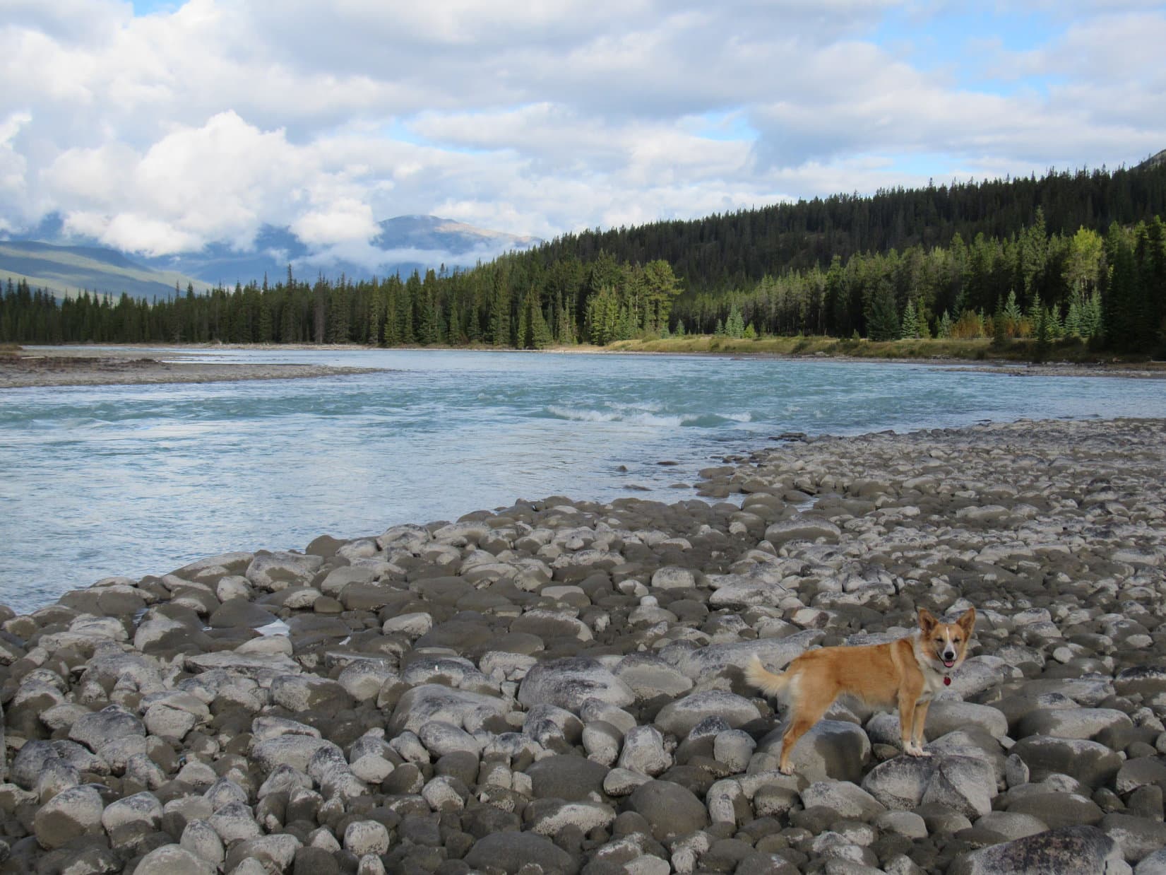
Between these falls, Lupe got to stop at her favorite picnic ground along the Athabasca River.  The American Dingo enjoyed a romp through the forest looking for squirrels, but didn’t see any.

Sunwapta Falls. Photo looks NE.
Near the brink. Photo looks NE.
Athabasca River from Lupe’s favorite picnic ground. Photo looks S.
At Athabasca Falls.
Mount Kerkeslin (9,698 ft.) from Athabasca Falls. Photo looks SE.

After a quick refueling stop in Jasper, the RAV4 rolled on, taking Lupe W into British Columbia on Yellowhead Hwy No. 16.  The American Dingo got out briefly for a look at Moose Lake, and yet again for a pleasant trek down to Overlander Falls, where she scrambled among the rocks by the huge swirling whirlpool below it.

Moose Lake. Photo looks WNW.
Overlander Falls in Mount Robson Provincial Park.
How Overlander Falls got its name.
Down by the whirlpool.

The evening ended on a gloomier note with Mount Robson (12,989 ft.), highest peak of the Canadian Rockies, shrouded in clouds and light rain.

At least we got to see Mount Robson before, SPHP.  Remember when we went through the Valley of a Thousand Falls all the way to Berg Lake?

Yes!  A fantastic trail, Looper.  We ought to do that again someday.

8-3-22, 7:31 AM – Fog drifted among the mountains.  Still overcast, gray clouds spit light rain.  Good day for a long drive!  Arriving fairly early, Lupe did get out of the RAV4 for a little while to visit Rearguard Falls, which she had all to herself this morning.  Like all the other waterfalls Looper had been to yesterday, the sheer volume and power of the flow was overwhelming.

Rearguard Falls is the upper limit of the Fraser River’s Chinook salmon run.
On the elaborate boardwalk leading down to the falls.
Right next to Rearguard Falls, which is actually more like a big rapids.
Rearguard Falls. Both Rearguard and Overlander Falls are on the Fraser River.
By the Fraser River just upstream of Rearguard Falls.

The next stop came 1.5 hours later at the Goat River rest area, a favorite secluded spot on the way to Prince George.  Without any signage, SPHP missed the turn, and had to go back.

Enjoying a sniff at the secluded Goat River rest area.
Along the Goat River near the Yellowhead Hwy No. 16 bridge.
Goat River downstream view.

Lupe’s final stop before Prince George was at the Ancient Forest.  With time somewhat of the essence, the Carolina Dog did only the basic main loop, instead of the entire trail system as she’d done once before.  That still allowed her to visit both Treebeard and the Radies Tree again, two enormous 1,000 year old western red cedars.

Arriving at the Ancient Forest.
Lupe explored only the main loop (in green) today.
On the raised boardwalk near the start of the loop.
About the ancient western red cedars.
Among the ferns on the way to the upper part of the loop.
Treebeard, named after J.R.R Tolkien’s ent from middle earth.
Info about the Radies tree.
Radies tree.

With many miles to go, it could rain all day long, if it wanted to, which it did off and on.  Lupe snoozed on her pink blanket most of the afternoon, occasionally opening an eye to gaze out the window.  Going to Alaska!  Could anything be more fun?  The drive through the drizzle was so very scenic and soothing.  A marvelous day!

8-3-22, 5:22 PM – The afternoon was about shot by the time Lupe reached her next stop of any significance.  Can’t miss the dazzling flower gardens at Steelhead Park in the little town of Houston!  An impressive variety of lilies seemed to be the specialty this year.

Steelhead Park in Houston, British Columbia.
Lilies.

Many other kinds of flowers and decorative plants were featured, too.  Steelhead Park isn’t very big, so Lupe had time to visit nearly the entire collection.  The only genuine disappointment was that the fountain still wasn’t working.  It hadn’t been in 2019, either, the last time Loop was here, but had always been operational before then.

Another colorful display.
By the Steelhead fountain.

Wonder why they don’t fix it, SPHP?  The fountain was always such a lovely centerpiece!

Lack of funds, I suppose, Looper.  Seems a shame, doesn’t it?

8-3-22, 6:21 PM, Telkwa – The sky remained overcast as Lupe stood on a new sidewalk on a levee overlooking the Bulkley River.

Bulkley River, Telkwa, British Columbia.

Not much farther to Smithers now, Looper.  We’ll be there soon.

Smithers!  That’s where Hudson Bay Mountain (8,494 ft.) is, SPHP!  And the Babine Mountains, too.  Remember Harvey Mountain, the Onions, and Astlais Mountain?

Sure do, Loop!  Hope the weather clears up tomorrow!  Been 5 days, and we’re nearly 1,800 miles from home now.  That ought to be about enough driving for a while.

Oh, are we going to climb a mountain tomorrow, SPHP?

If the weather cooperates, Loopster.  We’ll see.

On the way to Smithers, a small patch of blue appeared to the N, and the sky brightened to the W.  At dusk in Driftwood Canyon, it almost looked like the whole sky was starting to clear, but it was hard to tell for sure.

Along the Bulkley River, Telkwa, British Columbia, Canada 8-3-22

Links:

Next Adventure                         Prior Adventure

Want more Lupe adventures?  Choose from Lupe’s Summer of 2022 Dingo Vacations to Wyoming, Canada & Alaska Adventure Index, Dingo Vacations Adventure Index or Master Adventure Index.  Or subscribe free to new Lupe adventures.

Parker Ridge & the Saskatchewan Glacier, Banff National Park, Canada (9-6-16)

Day 39 of Lupe’s Summer of 2016 Dingo Vacation to the Canadian Rockies, Yukon & Alaska

6:20 AM on this beautiful early September morning found Lupe already on the road, heading SE on Yellowhead Highway No. 16.  Ever since leaving Alaska, Lupe had made her 450 mile daily quota or a little more.  Today she didn’t need to go so far.  She could spent part of the day visiting some favorite places in the Canadian Rockies.

Lupe’s first stop came before mid-morning when she reached her favorite picnic ground in Jasper National Park.  For some unknown reason, there’s no signage for this great picnic area right along the E bank of the mighty Athabasca River.  It’s located 5 or 6 miles S of Athabasca Falls along the W side of Icefields Parkway Hwy 93.

The Athabasca River was much lower than Lupe had ever seen it before, but until today she had never been here this late in the season.  Previously, the river had always come right up to the bank at the edge of the picnic ground.  Now a wide expanse of riverbed was exposed beyond the bank.  Lupe went down to the riverbed, and trotted over rounded stones to the water’s edge.

Lupe had never seen the Athabasca River so low before. She went way out across exposed riverbed to this boulder. Photo looks upstream (SE).
Loop at the Athabasca River near her favorite picnic ground.

Every other time Lupe had seen the Athabasca River, it had been a light gray color, running high, and full of silt.  Now the river was a beautiful blue.

When the Athabasca River is running higher, it is a light gray color and full of silt. Today the river was running low and a beautiful blue. Photo looks downstream (NW).

Time for a late breakfast.  After checking out the river, Lupe returned to the picnic ground.  While SPHP heated up soup and Swiss Miss, Lupe had a fine time barking at squirrels in the trees.  When breakfast was ready, Lupe helped SPHP devour the soup.  She didn’t get any Swiss Miss.

Lupe got to spend nearly 2 hours at the picnic ground.  She took short walks through the forest along the river with SPHP, barked at squirrels, and returned to the Athabasca River.

Looking upstream again toward Mount Christie (10,236 ft.). Photo looks S.
Happy times at the Athabasca River in Jasper National Park! Mount Christie in the background. Lupe’s still keeping a sharp eye out for squirrels up in the trees on the riverbank. Photo looks S.

Late in the morning, another vehicle pulled in to the picnic ground.  No doubt more would be coming as lunch time approached.  Lupe and SPHP hit the road again.  Icefields Parkway Hwy 93 through the majestic Canadian Rockies is always a spectacular drive.

Lupe and SPHP enjoyed the scenery, passing by many gorgeous places Lupe had explored on her 2013 and 2014 Dingo Vacations.  Lupe didn’t stop again, however, until she reached the trailhead for Parker Ridge (7,612 ft.).  By now it was early afternoon, and the trailhead parking lot was packed.  SPHP had to wait for a parking spot to open up.

Parker Ridge is Lupe and SPHP’s favorite short day hike in the Canadian Rockies.  A well-traveled trail switchbacks up the side of the ridge.  On the other side is a tremendous view of the huge U-shaped valley carved long ago by the Saskatchewan Glacier.  The glacier can still be seen in the upper part of the valley flowing down from the Columbia Icefield.  The trail gains over 800 feet of elevation on its way to the ridgeline.

The Parker Ridge Trail was very busy, but the glorious view of the Saskatchewan Glacier from the other side of the ridge made dealing with the crowd totally worthwhile.

Once over the ridgeline, Lupe had fantastic views of the Saskatchewan Glacier. Photo looks SW.
The Saskatchewan Glacier from Parker Ridge. Photo looks SW using the telephoto lens.

The way the terrain is configured, Lupe’s view of the Saskatchewan Glacier actually improved as she followed the trail on the other side of Parker Ridge away from the glacier.  More of the toe of the glacier could be seen from here.

The farther Lupe followed the trail away from the Saskatchewan Glacier, the more she could see of the glacier’s toe and the pond below it. Photo looks SW.
Looking W along Parker Ridge. On the other side of these mountains is Jasper National Park and another impressive glacier. The Athabasca Glacier can be seen from Icefields Parkway Hwy 93, but for a truly amazing view of it, Lupe recommends taking the trail to Wilcox Pass.
The Saskatchewan Glacier flows down from the Columbia Icefield, the largest icefield in North America’s Rocky Mountains.

Saskatchewan Glacier from Parker Ridge using the telephoto lens. Photo looks SW.
An even closer look at the toe of the Saskatchewan Glacier through the telephoto lens.
Across the huge valley carved by the Saskatchewan Glacier, Lupe saw high peaks and impressive snowfields. Photo looks SSW.

Lupe followed the Parker Ridge trail far enough away from the Saskatchewan Glacier to where she could see its entire toe.

Lupe with a view of the entire toe of the Saskatchewan Glacier from Parker Ridge.
A close-up showing the entire toe of the glacier.

Several groups of people had gone this far along the trail, too.  Everyone was hanging around enjoying the glacier view.  After several minutes, Lupe realized people and Carolina Dogs weren’t the only ones interested in being here.  A mountain sheep wandered up the steep side of Parker Ridge from the valley below, likely more interested in finding something to eat than the grand view.

After all, mountain sheep are so used to splendid scenery they pretty much take it for granted.  A good meal can be harder to come by.

A mountain sheep wandered up to the Parker Ridge trail from the deep valley below. The sheep seemed used to people, but rather alarmed to be confronted with the presence of an American Dingo!
When the mountain sheep saw Lupe, it hesitated before coming any farther up. Lupe and the mountain sheep were both extremely interested in each other, but for different reasons.
For mountain sheep in the Canadian Rockies, spectacular scenery is easy to come by. Photo looks ESE from close to the end of the Parker Ridge trail.

For a few minutes, Lupe and the mountain sheep had a stare down.  Lupe was a very good American Dingo.  She did not bark or lunge at the sheep.  She wouldn’t have gotten anywhere anyway, since she was on her leash.

Lupe and the mountain sheep stared each other down for several minutes before the sheep decided it was safe to come farther on up Parker Ridge.

When Lupe didn’t do anything except stare in rapt attention, the mountain sheep decided maybe it was safe to come farther on up Parker Ridge.  It turned out this sheep was an advance scout.  Several more mountain sheep suddenly made their appearance.

The first mountain sheep was only a scout. When the scout decided it was OK to advance despite Lupe’s presence, the rest of the flock started appearing. Six sheep ultimately came into view.

A total of six mountain sheep came up onto Parker Ridge from below.  Lupe still didn’t bark, but the sight of all these mountain sheep wandering around nearby was almost more than she could bear.  The Carolina Dog was trembling with excitement from nose to tail.  She kept glancing up at SPHP pleading to be turned loose.  She was absolutely 110% certain fresh mutton would taste better than the soup she’d had for breakfast.

This situation wasn’t going to be sustainable.  To Lupe’s enormous disappointment, SPHP insisted that she head back away from the mountain sheep.  She was most reluctant to comply, but in the end, she had no choice.  Parker Ridge had certainly been an exciting adventure, but oh, how much better it might have been!

Lupe on Parker Ridge on the way back to the G6. Mount Wilcox (9,462 ft.) is in view at Center. To the R is Wilcox Pass, where there are tremendous views of the nearby Athabasca Glacier. Photo looks NW.

Lupe and SPHP returned to the G6 (3:48 PM, 48°F).  Lupe continued S on Icefields Parkway Hwy 93.  Her biggest adventure for the day up on Parker Ridge was over, but she still had some fun ahead of her.  Overcome with drowsiness from the gorgeous, relaxing drive, SPHP eventually parked the G6 at Lupe’s favorite picnic ground in Banff National Park on the SE side of Bow Lake.

After an hour’s nap, Lupe got to go see wonderful Bow Lake.

Lupe at beautiful Bow Lake. Photo looks W from near the picnic ground.
The red roof of the Num Ti Jah Lodge is in view at the foot of Mount Jimmy Simpson (9,731 ft.) across Bow Lake. Photo looks NW.
Looking S along the shore.
On a path at the picnic ground. No one else was around. Lupe and SPHP had the whole place to themselves.

The picnic ground was completely deserted, even though it was dinnertime.  After a good look at Bow Lake, SPHP prepared dinner at a table near the shore.  At this late stage of Lupe’s Summer of 2016 Dingo Vacation, supplies were almost completely exhausted.  Lupe and SPHP shared the last of the soup and sardines.

Good thing Lupe was well on her way home!  Swiss Miss and tea was all that remained to sustain SPHP, though Lupe still had some Taste of the Wild and Alpo in reserve.

By the time this feast was over it was 7:00 PM, but there was still light in the sky.  Lupe and SPHP drove over to the Num Ti Jah Lodge at the N end of the lake.  Lupe went down to the shore and saw a curious thing.  A piece of wood was swimming around as if it were alive!

Near Num Ti Jah Lodge, Lupe saw a curious sight. A piece of wood was swimming around in Bow Lake as if it were alive!

Lupe had spotted a beaver!  The beaver paddled around near the shore completely unconcerned by Lupe’s presence.  Lupe wasn’t really certain why that piece of wood seemed so lively, but finally lost interest in it since it never came out of the water where it could be properly sniffed and inspected.

The beaver paid Lupe no attention. Since it never left the lake, Lupe eventually lost interest in it.
The beaver had a short stick it was gnawing the tender thin bark off of.
After a few minutes, the stick didn’t have much bark left. The beaver looked quite satisfied with this treat.
After a few minutes, the lively piece of wood (seen beyond Lupe) swam away. Photo looks SSE across Bow Lake. Part of the Crowfoot Glacier is in view R of Center beyond the opposite shore.
Lupe, the beaver, Bow Lake & the Crowfoot Glacier.

The beaver eventually swam away farther out into the lake.  Lupe never did figure out what made that floating piece of wood so much livelier than any other she’d ever encountered.

Off to the SW, part of Bow Glacier and Bow Glacier Falls were in view.  A trail that Lupe took once before on her Summer of 2013 Dingo Vacation goes all the way to the base of Bow Glacier Falls.  It would be dark long before Lupe could do that again, but there was still time to follow the trail partway along the N shore of Bow Lake.

Beyond Bow Lake, part of the Bow Glacier and Bow Glacier Falls were in view. Photo looks SW.
Bow Glacier & Bow Glacier Falls using the telephoto lens. Photo looks SW.
Too bad there wasn’t time to take the trail all the way to Bow Glacier Falls again, but it would be dark before Lupe could get there. It’s a great, easy, scenic hike with a good trail and very little elevation gain along the way. Lupe highly recommends it!
Num Ti Jah Lodge is at the N end of Bow Lake. The trail to Bow Glacier Falls starts here. Photo looks N.
This hefty, wooden bridge crosses a small creek entering Bow Lake near Num Ti Jah Lodge. Photo looks SSE.
Bow Glacier flows down from the Wapta Icefield. Another small lake exists out of sight below Bow Glacier above the falls. Neither the small upper lake, nor the glacier are visible from the base of Bow Glacier Falls. However, a distant view of both, plus part of the enormous Wapta Icefield can be seen from Cirque Peak (9,820 ft.). Photo looks SW.

Lupe and SPHP only took the trail to Bow Glacier Falls along the N shore of Bow Lake for 20 minutes.  Lupe hadn’t even made it to the end of the lake yet when the time came to turn around.  Darkness was coming, maybe rain, too.  The sky was clouding up.

Lupe on the trail to Bow Glacier Falls. She would have to turn around in another 10 minutes due to oncoming darkness. Crowfoot Mountain is on the L.
Clouds were rolling in and starting to hide the mountains. The sky looked increasingly like rain was a possibility. Photo looks SSW using the telephoto lens toward a peak S of Bow Glacier.
Bow Glacier & Bow Glacier Falls through the telephoto lens from the point of Lupe’s farthest advance along the trail.
The upper portion of Bow Glacier Falls with the telephoto lens cranked up.

On the way back to the Num Ti Jah Lodge, a gentle steady rain did start falling.  The lodge was lit up and looked inviting when Lupe returned.  The soggy Carolina Dog couldn’t go in, though.  She had to return to the G6.

Num Ti Jah Lodge was lit up and looked inviting when Lupe returned in the rain from the Bow Glacier Falls trail. The soggy Carolina Dog couldn’t go in, though. Back to the G6!

Around 8:30 PM, SPHP parked the G6 for the final time.  The steady rain was coming down harder.  The temperature was only 38°F.  Maybe Lupe was going to get snowed in overnight in the Canadian Rockies?  It sure seemed like a possibility.

Lupe had only made 250 miles today, but that was OK.  She’d spent a lovely day in the Canadian Rockies.  Maybe it wasn’t the most spectacular day she’d ever spent here, but she’d seen many beautiful sights, gone to some favorite places, and had several pleasant, relaxing outings.

Lupe’s only regret was that with supplies running desperately low, SPHP hadn’t allowed her to secure a great new supply of fresh mountain sheep mutton!

Sigh … Carolina Dogs try to be man’s best friend.  They really do.  Humans are hard to understand, though.  Sometimes they don’t have any sense at all.Note:  The Parker Ridge trailhead is located at a pullout right along the southbound side of Icefields Parkway Hwy 93 several miles S of Sunwapta Pass, the border between Banff & Jasper National Parks.

Links :

Next Adventure                       Prior Adventure

Parker Ridge & the Saskatchewan Glacier, The Icefield Centre & the Athabasca Glacier (7-23-13)

Bow Lake & the Trail to Bow Glacier Falls (7-25-13)

Cirque Peak, Banff National Park, Canada (7-24-14)

Parker Ridge Trail, Banff National Park, Canada (7-29-14)

Want more Lupe adventures?  Choose from Lupe’s 2016 Canadian Rockies, Yukon & Alaska Adventure Index, Dingo Vacations Adventure Index or Master Adventure Index.  Or subscribe free to New Lupe Adventures.

Parker Ridge & the Saskatchewan Glacier, The Icefields Centre & the Athabasca Glacier (7-27-13)

7-23-13.  The 18th Day of Lupe’s 2013 Dingo Vacation to the Beartooths and Canadian Rockies.  Lupe and SPHP woke up fairly early, around 6:30 AM.  It was already light out, of course, and had been for over an hour.  The sky was a brilliant blue and the sun shone brightly on the mountain peaks to the W.

Lupe and SPHP were still in the shadows of the mountains to the E.  Lupe and SPHP went down to the bridge they had crossed the previous evening when Lupe had gone to see Chephren and Cirque Lakes.  For a few minutes, Lupe and SPHP just stood on the middle of the bridge looking at the Mistaya River and enjoying the moment.

Then it was time to go.  Lupe had things to do!  SPHP was really looking forward to it, too.  Lupe was going to go on the most anticipated trek of the entire vacation, the short hike up to Parker Ridge for a magnificent view of the Saskatchewan Glacier!  After a quick breakfast, Lupe and SPHP headed N in the G6 along the Icefields Parkway Hwy 93.

Even from the highway, there were great views of snow-clad peaks all around.  N of Saskatchewan Crossing, the impressive North Saskatchewan River meandered through the huge valley just W of the Icefields Parkway.  A medium-sized black bear ran across the highway from the (W) river side to the (E) mountain side of the highway.  Lupe saw it.  It was the first bear she had seen on this trip and she got a very good look at it.  She barked ferociously.  The bear took no apparent notice of the noisy dingo whizzing on by.

Climbing up past the big loop in Hwy 93, the skies suddenly darkened.  It wasn’t any more than 4 or 5 more miles up to the Parker Ridge turnout.  Lupe was soon at the Parker Ridge trailhead right alongside the Icefields Parkway, but the weather was suddenly very threatening.  Dark clouds with heavy fingers of fog were rolling down the mountainsides from the NW.

Lupe and SPHP got out of the G6.  SPHP checked out the map on display at the Parker Ridge trailhead.  A chill wind was blowing.  Within just a minute or two, a cold rain descended on Lupe and SPHP.  Clearly conditions were not favorable for climbing Parker Ridge.  Even if Lupe and SPHP could endure the cold wind and rain and get up on the ridge, there wouldn’t be anything to see in the fog. Lupe wisely jumped back in the G6 before she got bone-chilling soaking wet.  Carolina Dogs know enough to come in out of the rain.

SPHP decided Lupe might just as well head on over Sunwapta Pass to the Icefields Centre near the Athabasca glacier, which wasn’t far away.  At Sunwapta Pass, Lupe left Banff National Park and entered Jasper National Park for the first time.  It was still quite early and people were just starting to arrive when Lupe and SPHP pulled in to the parking lot at the Icefields Centre.  A cold rain was coming down steadily.  The whole sky looked as dark and threatening as if a huge November blizzard was about to strike.  Across the highway, the Athabasca glacier and surrounding snow-covered peaks loomed gloomily and mysteriously through the fog.

The Icefields Centre had just opened.  Lupe stayed in the G6, while SPHP went in to see if there was any weather forecast available.  Lupe’s bright cheerful summer day had changed to a very convincing display of the onset of winter in the span of 30 minutes.  The weather looked so bad outside, SPHP had started thinking that if this was really a major front moving in, maybe the Athabasca glacier was as far as Lupe would get on here 2013 Dingo Vacation.  The notion that Lupe was going to miss out on climbing Parker Ridge and seeing the Saskatchewan glacier was very disappointing.

SPHP talked to a young woman at the information desk and asked for a weather forecast for Jasper for the next few days.  Someone else was interested in the same information.  She got on her computer and checked it out.  Today and tomorrow would be rather iffy with thunderstorms possible, with highs of 17°C (63°F) and 20 degrees C (68°F) expected.  The following two days were supposed to be clear and 25°C (77°F).  SPHP was relieved.  The forecast was far less ominous than the weather outside.  SPHP returned to join Lupe in the G6 and wait.

The rain continued for the better part of an hour.  Lupe snoozed.  SPHP read.  By the time an hour was up, the rain had pretty much stopped.  Lupe and SPHP could see a little patch of blue sky trying to peek through over the Athabasca glacier.  The weather improved rapidly.  The little patch of blue sky was growing and spreading out fast from the Athabasca glacier.  Soon the mountainsides 1,000 feet above the Icefields Centre parking lot were becoming visible revealing a significant dusting of new snow.

Clearing skies over one of Lupe and SPHP's very favorite mountains in the Canadian Rockies, Mt. Athabasca (11,453 ft.)
Clearing skies over one of Lupe and SPHP’s very favorite mountains in the Canadian Rockies, Mt. Athabasca (11,453 ft.)
Crisp, clear and clean with a new dusting of snow. Mt. Andromeda (11,286 ft.) and the Athabasca Glacier.
Crisp, clear and clean with a new dusting of snow on the heights. Mt. Andromeda (11,286 ft.) and the Athabasca Glacier.
Snow Dome (11,483 ft. on L) and Mt. Kitchener (11,417 ft. on R) with the Dome Glacier between them. Jasper National Park 7-27-13
Snow Dome (11,483 ft.)(L) and Mt. Kitchener (11,417 ft.) (R) with the Dome Glacier between them. Jasper National Park 7-27-13
The Icefields Centre in Jasper National Park. Tickets for snowbus tours that go right up onto the Athabasca Glacier and guided walks on the toe of the glacier are available here.
The Icefields Centre in Jasper National Park. Tickets for snowbus tours that go right up onto the Athabasca Glacier, and guided walks on the toe of the glacier are available here.
Clearing skies over Snow Dome, another favorite mountain.
Clearing skies over Snow Dome, another favorite mountain, and the Dome Glacier.  Snow Dome is the only spot on earth (outside of Antarctica) from which water flows to 3 different oceans.
Clear skies over Mt. Andromeda and the Athabasca Glacier. Time for Lupe to go climb Parker Ridge to see the Saskatchewan Glacier!

SPHP was elated!  Lupe was not only going to get to go up Parker Ridge to see the Saskatchewan Glacier, but the scene would be even more fantastic with a dusting of new snow on the mountains.  Lupe and SPHP headed back to the Parker Ridge turnout.  Other people were already gathering there for the hike up as well.  The climb along the excellent trail only takes 45 minutes or so to reach the crest of Parker Ridge.

The Saskatchewan Glacier is visible flowing down from the Columbia Icefield near the head of the huge valley on the other side of Parker Ridge.  Except it wasn’t.  The valley below was full of fog when Lupe first arrived.  Lupe and SPHP waited for it to clear.  SPHP chatted with a couple of guys from Edmonton.  After 20 or 30 minutes, the fog started dissipating.  Eventually it disappeared entirely.

Looking SE from Parker Ridge down into the lower portion of the glacial valley. The glacier (not shown) has retreated to the upper end of this long valley.
Looking S directly across the valley from Parker Ridge.
The Saskatchewan Glacier flows down from the Columbia Icefield.
Lupe on Parker Ridge 7-27-13

Lupe on Parker Ridge, Canada 7-27-13Lupe on Parker Ridge & Saskatchewan Glacier 7-27-13Lupe and SPHP wandered around up on Parker Ridge for quite a while.  Different vantage points gave slightly different perspectives.  Due to the lay of the terrain, climbing higher up on the ridge seemed to just hide more of the glacier from view.  Some of the best vantage points were achieved by following a trail towards the E along the edge of the valley going away from the glacier.

Saskatchewan Glacier from Parker Ridge 7-27-13

Saskatchewan Glacier, Canada 7-27-13

The E end of the Saskatchewan Glacier valley as seen from Parker Ridge. The Icefields Parkway Hwy 93 is visible way down below.
The E end of the Saskatchewan Glacier valley as seen from Parker Ridge. The Icefields Parkway Hwy 93 is faintly visible way down below.
Heading back down to the G6 along the Parker Ridge trail in northern Banff National Park, Canada.

On the way back down to the G6, Lupe was amidst a crowd of tourists coming up or going back down.  Lupe made a few new acquaintances along the way.   Once back to the G6, Lupe and SPHP headed N again on Icefields Parkway Hwy 93 over Sunwapta Pass (the border between Banff and Jasper National Parks).  SPHP drove on down to the Icefields Centre again, but this time turned off the opposite side of the Icefields Parkway and went down to the parking lots below the Athabasca Glacier.

The parking lots were 80% full and there were a lot of people around.  Not exactly a wilderness experience, but where else can you drive practically up to the toe of a big glacier?  A short trail led Lupe to a viewpoint well short of the glacier’s edge.  Fences and lots of signs warning of the extreme dangers posed by glaciers blocked any further advance.  It was all typical over-the-top hype that applies to everything these days, but whatever.  (Drizzle on Jersey turnpike!  Millions affected!  Take appropriate precautions and stay tuned for further updates!)

Toe of the Athabasca Glacier, Canada 7-27-13
Lupe near the toe of the Athabasca Glacier, Jasper National Park, Canada 7-27-13
People on the Athabasca Glacier. Presumably they bought tickets at the Icefields Centre to one of the guided walks on the glacier.

Lupe at the Athabasca Glacier, 7-27-13The Athabasca Glacier was making its own weather.  A strong, chill wind blew down off it into Lupe’s face.  Away from the glacier, summer had returned.  Close to it, cold locked in the ice during winters long centuries ago made itself felt one more time.

Lupe returned to climb Parker Ridge on 7-29-14 for a second time during her 2014 Dingo Vacation to the Beartooths and Canadian Rockies.  Click on the Parker Ridge link to see Lupe’s post on that ascent!

Links:

Next Adventure                    Prior Adventure

Want more Lupe adventures?  Choose from Lupe’s 2013 Beartooths & Canadian Rockies Adventure IndexDingo Vacations Adventure Index or Master Adventure Index.  Or subscribe free to new Lupe adventures.