Black Hills, SD Expedition No. 102 – St. Elmo Peak & the Search for Peak 6733 (10-29-14)

The sign said “Enjoy Your Day, But Please Close the Gate, Cattle Summer Pasture in these Fields”.  Well, OK.  October 29th wasn’t really the time of year for summer pasture, and although mountain goats might like it, the steep forested slopes up ahead didn’t look like good pasture for cattle any time of year.  Nevertheless, Lupe and SPHP went through and closed the gate.

Lupe was just starting out on Black Hills, SD Expedition No. 102.  She was only a couple of minutes from the G6, which SPHP had parked along a dirt road SSE of Hwy 385, about a half mile S of its junction with Hwy 87/89 (10:37 AM, 54°F).  Her first peakbagging objective for the day was St. Elmo Peak (6,458 ft.), less than a mile to the S.  Lupe would have to gain over 1,200 feet of elevation to get up on top.

Beyond the fence, Lupe and SPHP started climbing the rough remnant of a road up a steep gully.  The road became an overgrown trail, and then disappeared.  Lupe hadn’t gone too far when the terrain started leveling out.  She reached a small saddle NW of St. Elmo Peak.  Lupe and SPHP turned SE, and headed straight up the mountain.

Lupe came across a seldom used dirt road.  Brief explorations revealed that it was going to lose elevation no matter which direction Lupe might choose.  So, Lupe and SPHP abandoned the road to resume climbing.  Somewhat higher up, Lupe came to another road.  It went down to the S, but looked like it would gain elevation going N.  Lupe and SPHP followed it N.

Within 5 minutes, Lupe came to a wide spot where there were clear views off to the N and NE.  The road continued around to the N side of St. Elmo Peak, reaching its highest point at a closed gate.  Beyond the gate, the road was blocked by deadfall timber as it started downhill.  Once again, Lupe and SPHP resumed climbing straight up the mountain.

The climbing was now much tougher than before.  The forest was dead.  Countless pines lay shattered and scattered in every direction on the steep slope.  Thistles and low thorny bushes had grown in thick profusion amidst it all.  It took SPHP a long time to work up through the tangled mess.  Even Lupe wasn’t enjoying this much.  St. Elmo Peak itself was ugly, but there were great views to the N.

Finally, Lupe found a faint trail going up the mountain.  Even better, with only a few exceptions, someone had cleared the deadfall off the trail.  Lupe and SPHP started making much better progress.  There was still a good climb ahead, but it didn’t take much time.  The trail ended at a rock outcropping near the summit.  Lupe and SPHP scrambled up.

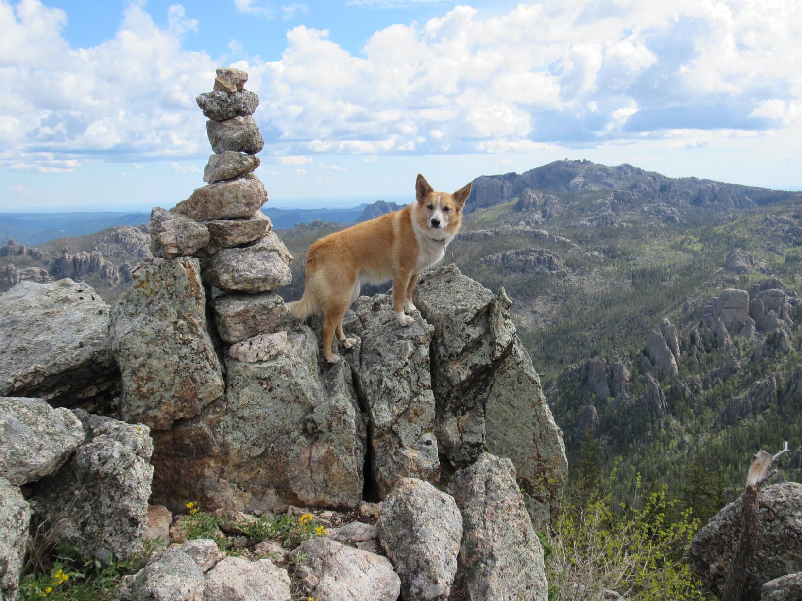
Lupe was now on a surprisingly large, and fairly level, block of granite.  To the E were cliffs and very steep slopes.  There were wonderful views from the NW all the way around to the NE and SE.  The view of Harney Peak (7,242 ft.) to the E was fabulous.  This big granite ledge at the N end of St. Elmo Peak was easily the best viewpoint on the mountain.

Lupe reaches the big granite viewing platform on top of St. Elmo Peak. She wasn't quite at the summit yet, but pretty close to it. Harney Peak (Center) is seen in the distance. Photo looks ESE.
Lupe reaches the big granite viewing platform on top of St. Elmo Peak. She wasn’t quite at the summit yet, but pretty close to it. Harney Peak (Center) is seen in the distance. Photo looks ESE.

Harney Peak from St. Elmo Peak, 10-29-14

Harney Peak (7,242 ft.) (L) and Little Devil's Tower (6,960 ft.) (R).
Harney Peak (7,242 ft.) (L) and Little Devil’s Tower (6,960 ft.) (R).

Whew, time for a break to enjoy the views and let lungs catch up!  Lupe and SPHP sat together on the big granite ledge.  Lupe had Taste of the Wild and water.  SPHP had water and carrots.  Lupe and SPHP watched smoke billowing up in the distance to the NNE from hills E of Hill City.

Smoke was billowing up from hills E of Hill City. Photo looks N.

Although the granite ledge was the best viewpoint, Lupe hadn’t quite reached the summit of St. Elmo Peak yet.  The true summit was to the S, hidden by a mixed forest of pines and young aspen.  After a few minutes spent recovering from the climb, Lupe and SPHP went S to find it.

The true summit was very close by.  Although the forest hid a quite a few boulders, it didn’t take Lupe long to find the highest one.  She leaped on top to claim her St. Elmo Peak peakbagging success!

Lupe on the true summit of St. Elmo Peak! Photo looks ENE.

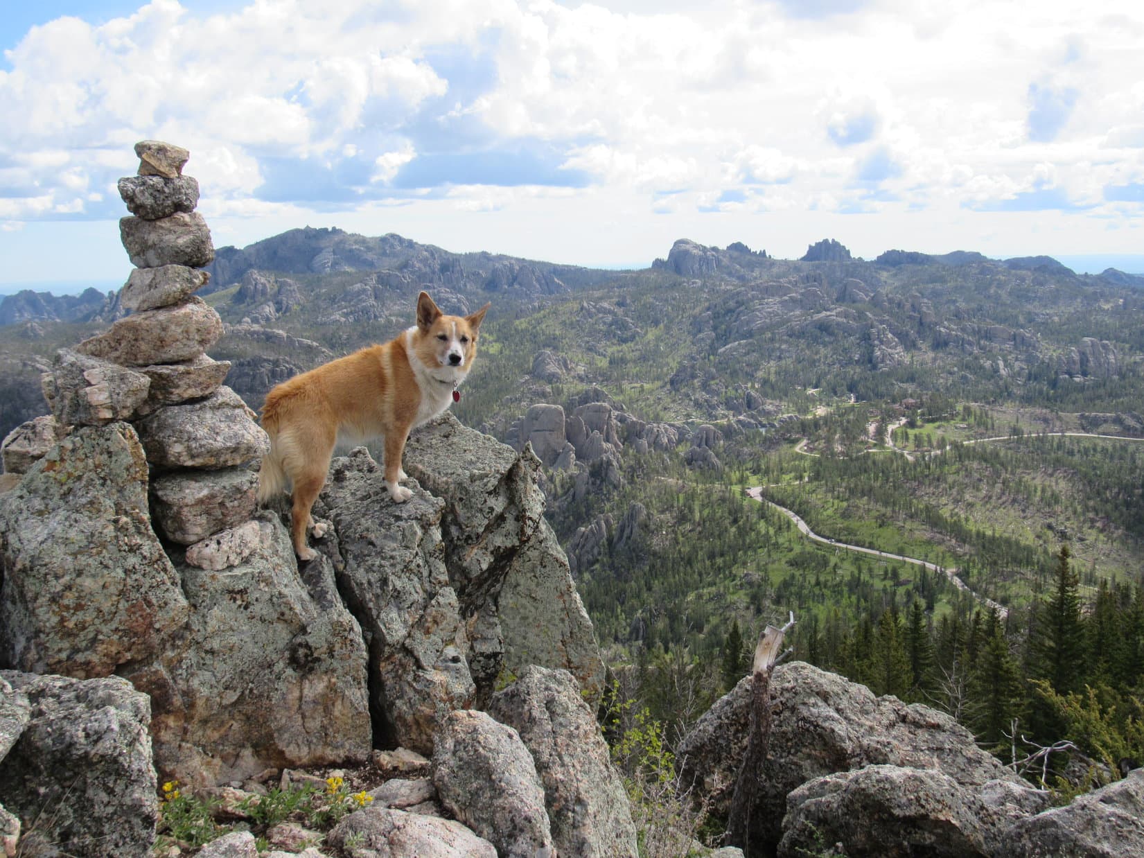
Lupe and SPHP returned to the big granite ledge.  Lupe agreed to pose for a few more photos.  The smoke E of Hill City looked like it was spreading.

Zimmer Ridge (6,600 ft.) is seen beyond Lupe. Photo looks NW.
Zimmer Ridge.
Zimmer Ridge.
The smoke E of Hill City looked like it was still spreading.

Lupe had made it to the top of St. Elmo Peak, but the longest and hardest part of Expedition No. 102 was still ahead of her.  She was just getting started!  Her next peakbagging goal was Peak 6733, which was still 3 miles to the S.  It was time for Lupe to get going.  Lupe and SPHP left the granite ledge, and headed back down the faint trail.

It turned out that the faint trail led all the way down to the wide spot on the upper road back where Lupe and SPHP had first started seeing views to the N.  SPHP hadn’t noticed the faint trail here before.  Lupe and SPHP got on the road and headed S.  It lost elevation steadily at a modest pace.  The road turned SW staying on the NW side of a long ridge coming down from St. Elmo Peak.

Eventually, the road curved W.  When it turned NW, it was time to look for a new route.  Walking over to the edge of a small rise, SPHP saw another road below to the SW.  It looked like it was heading SE for Bear Gulch, exactly where Lupe needed to go.  Lupe and SPHP left the upper road and headed down the slope.

The lower road was better than the one Lupe had left up above.  Lupe was very happy to find a creek running near it.  She laid down in the water to cool off and get a drink.  Lupe and SPHP went SE, and soon came to a fork in the road.  One fork continued to the ESE following the creek upstream into a narrow, densely forested part of the canyon.  That road was marked USFS Road No. 302.1F.

The other road was not marked.  It crossed the stream, and headed S gaining elevation along the W side of a big field.  Lupe took the unmarked road.  She gained a fair amount of elevation, and came to a side road marked as USFS Road No. 302.1H.  It went E, and looked like it was going to go around the N end of a ridge to the SE.  Lupe’s objective, Peak 6733, was 2 miles farther S along this same ridge.

SPHP thought about getting up on the N end of the ridge, but didn’t.  Instead, Lupe and SPHP followed No. 302.1H all the way around the N end over to the E side.  There, it turned out that No. 302.1H was absolutely choked with deadfall.  SPHP was optimistic that it would end soon.  Wrong!  The deadfall went on and on.  Lupe could get through it OK, but it was taking SPHP literally hours per mile.

Looking NE back at St. Elmo Peak from USFS Road No. 302.1H at the N end of the ridge that Peak 6733 is part of 2 miles farther S.

The struggle through the deadfall was exhausting.  Finally, No. 302.1H climbed fairly high up on the E side of the ridge.  The deadfall lessened and Lupe reached a small clearing.  Lupe and SPHP left the road to climb directly up to the top of the ridgeline.  It had taken so long to get here, SPHP wasn’t certain if Peak 6733 was still to the S or back to the N.  The top of the ridge was forested, so it was hard to tell.

It turned out the deadfall had slowed progress down even more than SPHP thought.  After a little scouting around, it was clear that the highest ground along the ridgeline was still farther S.  Peak 6733 had to be in that direction.  Lupe and SPHP trekked S following the ridgeline.  Lupe came to a series of successively higher points along the way.  Each time she got to the top of one, another even higher one appeared ahead.

There was plenty of deadfall timber up on the ridgeline.  It wasn’t as bad as back down on No. 302.1H, but it was certainly enough to make the going much slower than it should have been.  Several times, SPHP thought Lupe had reached the top of Peak 6733, only to quickly realize she hadn’t.  The sun was starting to sink toward the horizon.  Lupe was running out of time to reach Peak 6733.

Thunderhead Mountain (6,567 ft.), where the Crazy Horse memorial carving is located, came into view to the SW.  Lupe had to be getting close to Peak 6733.  Up ahead, another high point came into view.  This one was noticeably higher and steeper than the other high points Lupe had reached.  SPHP’s hopes rose again that this might be Peak 6733.

By the time Lupe and SPHP arrived at the top, it was only half an hour before sunset.  SPHP was already concerned with how Lupe was going to get back to the G6.  It was far too late in the day to even consider returning through the massive tangle of deadfall.  After checking out this high point, Lupe would have to try to find a way W to Hwy 385 before it got dark.

The top of this final high point had several high rock outcroppings of about equal elevation strung out along the E side of the ridge.  There was another rocky high point off to the W, but the forest made it difficult to tell which of all these points was the true summit.  Lupe would have to visit all of them.

A quick trek over to the W revealed that the rocks on the E side of the ridge were clearly higher.  Crazy Horse looked pretty close by to the SW.  Lupe returned to the high rock outcroppings on the E side of the ridge, exploring them all one by one.  There was a lovely carpet of kinnikinnick growing in the saddle area between the E and W sides of the ridge.

Looking NNE back at St. Elmo Peak (L) from the high rocks on the E side of the ridge at the last high point Lupe climbed on her search for Peak 6733.
Sylvan Hill (7,000 ft.) from the last high point. Photo looks E.
Lupe on the kinnikinnick carpet in the saddle area. Photo looks NE.

Near the S end of the E side of the ridge, Lupe found the highest rocks of all at this high point.  Lupe and SPHP managed to get up on the summit, which was a somewhat precarious rock only a foot or two wide.  Lupe posed for a summit photo.  It had to be a close up.  There wasn’t any room for separation.

Lupe on the summit of the final high point of the day. SPHP had to lean back to get all of Lupe in the picture. Success, but it still wasn't clear if this was Peak 6733 or not!
Lupe on the summit of the final high point of the day. SPHP had to lean back to get all of Lupe in the picture. Success, but it still wasn’t clear if this was Peak 6733 or not!
Nearing sunset at the summit.
Crazy Horse on Thunderhead Mountain taken from the summit.

From the S end of the high point, Lupe could see a big saddle to the SSE.  Beyond it was an even higher mountain than the one she was on.  She could see that it was part of the ridge that swept around to the E, and then back N over to Sylvan Hill (7,000 ft.) at its highest point.  If Lupe wasn’t already on the summit of Peak 6733, then that next mountain to the SSE had to be it.

The easiest way down off this high point was to go back to the N.  From there, Lupe and SPHP went E down off the ridge.  Lupe turned SSE, cutting through a field where the terrain wasn’t too steep.  Arriving at the saddle between the two high points, Lupe discovered a road with a gate.  The road wasn’t marked in either direction.

For a couple of minutes, SPHP considered going on to climb the higher peak to the SSE.  There was a good chance it was the real Peak 6733.  There really wasn’t time, though.  Lupe might make it up there while it was still light out, but it would be completely dark by the time Lupe could even get back to the saddle.  SPHP didn’t even know what return route Lupe should take from here, only that she couldn’t go back the way she’d come.

Nope, Lupe had to skip that peak to the SSE.  Just forget about it!  The best bet was to get a move on, and try to find a way W to Hwy 385.  If Lupe could get to Hwy 385, she should be able to find the Mickelson Trail.  Even in darkness, she could safely and easily follow the Mickelson Trail back to a point close to the G6.

So, Lupe and SPHP followed the road going SSW over the W side of the ridge.  As Lupe searched for a way to Hwy 385, she saw Crazy Horse in the early twilight.

Crazy Horse

P1050625Lupe eventually found Hwy 385, but not until well after dark.  Lupe and SPHP followed the Mickelson Trail N.  The wind blew.  Clouds swept by.  It rained lightly.  The sky cleared.  Half a moon and myriad stars shone above.  Far below the bridges, Tenderfoot Creek rippled along in the otherwise silent night.  For many  miles, the American Dingo trotted ahead on the long trail home.  (9:00 PM, 44°F)

It wasn’t until the next day, when SPHP had a chance to look carefully at the photos taken on Black Hills, SD Expedition No. 102 and compare them to the maps, that SPHP knew for certain whether Lupe had climbed Peak 6733, or not.  She had not.  The final high point that Lupe reached was High Point 6634, about 0.625 mile to the NNW.

Links:

Next Black Hills Expedition                    Prior Black Hills Expedition

Want more Lupe adventures?  Choose from Lupe’s Black Hills Expeditions Adventure Index or Master Adventure Index.  Or subscribe free to new Lupe adventures.

Black Hills, SD Expedition No. 103 – Peak 6733 (11-6-14)

Back on Black Hills, SD Expedition No. 102 on 10-29-14, Lupe had approached from the N to successfully climb St. Elmo Peak (6,458 ft.), but despite a valiant effort, she failed to reach Peak 6733.  Huge amounts of deadfall timber had choked the way.  It slowed SPHP down so much that Lupe ran out of daylight before reaching Peak 6733, although she did make it as far as Peak 6634 just 0.5 mile to the NNW.

On this beautiful warm morning in early November, SPHP had a new plan of attack for Lupe.  She would climb Sylvan Hill (7,000 ft.) and then follow the ridge around the S end of the valley to the W until she got to Peak 6733.  Trekking along this high ridge might be quite an adventure.  SPHP wasn’t certain how rugged it would be, but there could be some scenic and difficult to navigate large granite formations along the way.

Lupe didn’t get to find out.  At least 2 miles from where SPHP had intended to park the G6, Hwy 87/89 was barricaded.  The road was closed!  SPHP had never seen this part of Hwy 87/89 closed before, but it was now.  Well, what’s new?  Adventures often require flexible planning.  USFS Road No. 352 left Hwy 87/89 heading W right in front of the barricade.  Time to see where it would lead.

SPHP expected No. 352 would head SW toward Peak 6733, and it did, but not until after it went NW first.  About 0.75 mile from Hwy 87/89, No. 352 entered the NE end of the long valley between Sylvan Hill and Peak 6733, where the road divided.  USFS Road No. 352.1B went W.  A sign said “Private Drive”.

Lupe needed to go S, anyway, and No. 352 continued in that direction.  Just a little past the fork in the road, SPHP parked the G6 along No. 352 (9:14 AM, 47°F).  The immediately surrounding terrain was nice and level.  The forest had been thinned and cleaned up.  It looked almost like a park.  Lupe was less than 0.5 mile S of St. Elmo Peak.  She would start her trek to Peak 6733 from here.

St. Elmo Peak from USFS Road No. 352. Photo looks N.

Lupe and SPHP headed S along No. 352.  With the change in starting points, SPHP had abandoned all thoughts of having Lupe climb Sylvan Hill, at least not before she climbed Peak 6733.  Instead, she was going to follow the road to the S end of the valley, get up on the ridge, and go directly for Peak 6733.

No. 352 gained elevation at a steady, moderate pace.  Within about 10 minutes, Lupe came to a green metal gate.  No vehicles could get past this point, so it was just as well that the G6 was parked back where it was.  Lupe and SPHP went around the gate and continued S, climbing steadily all the time.

The S end of the valley was less than 3 miles away.  SPHP expected the road would gain elevation nearly all the way, but when Lupe was a little over halfway there, suddenly No. 352 turned SW and started losing elevation rapidly.  The road went clear down to the bottom of the valley, where there was a junction with USFS Road No. 352.2A.  No. 352.2A headed back to the NW following a little stream down Bear Gulch.

The route No. 352.2A took looked grassy and inviting, but was headed the wrong way.  Lupe did go check out the stream for a big, cold drink before she was ready to leave this nice, secluded spot.

Happy Lupe cools down in the merry little stream flowing down Bear Gulch.

Lupe and SPHP got back on No. 352.  The valley narrowed a great deal just to the S, with towering rock formations on both sides.  The road led between them, following the creek upstream.

Once beyond the rock formations, Lupe was in the upper end of Bear Gulch.  Here the valley widened out considerably.  Much of the floor of the valley was a big grassy meadow.  This hidden area, protected on all sides by high forested ridges, seemed like it would be a popular place for deer to graze, but Lupe saw none.

No. 352 continued S along the E side of the big meadow.  Looking over at the big ridge to the W, SPHP saw a high point that was probably Peak 6634, the farthest point S Lupe had reached up on that ridge on Expedition No. 102.  It was hard to be certain, though.

Part of the big meadow in upper Bear Gulch. Peak 6634, the high point farthest S that Lupe reached along the ridge on Expedition No. 102, may be the one on the L.

Lupe came to a junction with USFS Road No. 352.2B.  It headed W across the meadow and disappeared into the forest.  Lupe and SPHP stayed on No. 352.  Soon another road, which was likely USFS Road No. 352.2D, branched off heading E.  Lupe was getting close to the S end of the valley.  She came to more little roads branching off in various directions.

SPHP was hoping to find USFS Road No. 352.2C, which should go SW before turning sharply to climb NNW up to a saddle on the ridge between Peak 6733 and Peak 6634.  When Lupe reached a road going SW, SPHP took it.  Soon unmarked roads were branching off of it in all directions.  Clearly, this wasn’t No. 352.2C.  The road continued SW deteriorating rapidly.  Before long, it disappeared entirely.  Lupe and SPHP were left climbing steeply straight up the ridge at the far SSW end of the valley.

Lupe reached the top of the ridge.  There would have been some great views to the N and S, but the forest was too thick to see much.  It looked like there might be a considerably higher point off to the SE hidden by the trees.  Another less prominent high point was close by to the WNW.  Peak 6733 had to be somewhere NW of there.

Down in the valley, No. 352 had been almost entirely free of any deadfall timber.  Up here on the high ridge, there was plenty of it.  Lupe explored while SPHP worked slowly along the ridgeline, picking a way through the deadfall.  There were frequent granite outcroppings along the way, and occasionally some pretty good views toward St. Elmo Peak or Sylvan Hill.

Lupe and SPHP went up and down following the ridgeline from one granite outcropping to the next.  Some of them were large enough to force SPHP around them.  Others were easily traversed.  Gradually the ridgeline curved to the NNW.  Peak 6733 came into view.  There was a considerable drop from the last high point Lupe went over down into the saddle leading to Peak 6733.  On the way down, Lupe found the only really clear look at Peak 6733 ahead.

Peak 6733 lies ahead! Photo looks NNW.
Lupe and SPHP climbed directly up this SSE spine of Peak 6733.

There was a lot of deadfall timber and several big granite outcroppings on the way up the SSE spine of Peak 6733, but Lupe and SPHP made it up the mountain.  At the very top was a large steep granite formation.  SPHP had to climb slowly and carefully up the last dozen feet, lift Lupe up on top, and then crawl up there, too.

The summit was surprising.  A narrow band of granite a few feet wide, and all about the same elevation, snaked around for 20 or 30 feet.  There were sheer, but not particularly high drop offs on both sides.  Still, they were plenty high enough so one really should take care not to fall off.  Lupe was fine up there, but SPHP crawled along the granite path looking for a more secure place.

Lupe up on the narrow ridge of granite on top of Peak 6733. Photo looks WNW.
Lupe relaxes enjoying her Peak 6733 peakbagging success! Photo looks SW.

Somewhat surprisingly, SPHP only had to crawl along the granite for ten feet or so before it became evident that there was a small patch of level ground nearby to the NW.  It was almost as high as the summit.  SPHP scrambled over there, and got off the granite.

Now both Lupe and SPHP could relax and enjoy the views.  SPHP sat on the ground petting Lupe and taking a break.  Water and Taste of the Wild for Lupe.  Water and a golden apple for SPHP.  After eating, it was time for a few photos from seldom visited Peak 6733.

St. Elmo Peak (L) looks a lot smaller from Peak 6733! Photo looks N.
Sylvan Hill (Center) from Peak 6733. Photo looks NE.

Thunderhead Mountain (6,567 ft.), only 0.75 mile to the W, presented the most interesting view from Peak 6733.  Lupe had a great view of the rarely seen E side of the Crazy Horse memorial carving on Thunderhead Mountain.  The Crazy Horse carving has been in progress for decades, and is still far from being finished, but remains a popular tourist attraction in the Black Hills.

From Peak 6733, Lupe had this great view of the Crazy Horse carving on Thunderhead Mountain. The Crazy Horse memorial is a popular Black Hills tourist attraction, but most tourists normally see it from the other side. Photo looks W.

When it was time to leave Peak 6733, Lupe took a different route back than the way she had come up.  Lupe and SPHP worked around the SW and then W sides of the large granite outcropping at the top of the mountain.  The route was a real tangle of deadfall timber and thistles, but eventually Lupe regained the ridgeline N of Peak 6733.  She fought through more deadfall going N along the ridge all the way to USFS Road No. 352.2C at the saddle just S of Peak 6634.

Getting to No. 352.2C brought relief from all the deadfall timber.  Lupe and SPHP followed the road as it wound down into the upper end of Bear Gulch to the E.  It eventually led to USFS Road No. 352.2B, which brought Lupe to No. 352.

There were still a couple of hours left before sundown.  If Lupe was going to climb Sylvan Hill, now was the time to do so.  SPHP dithered.  Lupe had been on Sylvan Hill once before almost 6 months ago.  She climbed it from a different direction on Black Hills, SD Expedition No. 89 on 5-17-14.  The views were fantastic, but there had been a lot of deadfall timber to contend with along the summit ridge.

From upper Bear Gulch where Lupe was, it was over an 800 foot climb with no roads or trails.  Deadfall timber appeared to be strewn all over the steep ridge.  No doubt it would take a long time to reach the top, and another long time to get back down.  SPHP wanted to go, and Lupe was willing, but maybe it really wasn’t all that feasible even with several hours of daylight.  No sense getting stuck in the dark in a horrible tangled dead forest.

So instead of climbing Sylvan Hill, Lupe turned N on No. 352.  The road led her back between the big rock formations at the narrow part of the valley.  Lupe reached the merry creek bubbling along near USFS Road No. 352.2A.  It still looked inviting to explore the grassy valley along No. 352.2A.  So, Lupe did.  She eventually left No. 352.2A, and climbed up on some interesting granite formations where there was a nice view of St. Elmo Peak.

St. Elmo Peak from some granite formations down in Bear Gulch. Photo looks N.

Lupe’s explorations of Bear Gulch led her to USFS Road No. 352.1D, which in turn took her back to No. 352.  At 3:58 PM (55°F), Lupe was back at the G6.  Despite having taken a relatively easy return route, it was only 30 minutes until sundown.  Maybe that decision not to climb Sylvan Hill had been the right one!

It seemed a bit strange to be leaving for home before the sun was even down.  Lupe was happy enough, though.  She stood gazing intently out the windows of the G6 looking for deer, cows, horses or anything else it might be fun to bark at.  She had a great day climbing Peak 6733, and wasn’t disappointed on the way home either!

Note: Starting on USFS Road No. 352, the easiest and most direct up Peak 6733 would have been to take No. 352.2B heading W in upper Bear Gulch.  No. 352.2B leads to No. 352.2C.  Don’t follow No. 352.2C all the way NNW up onto the ridge.  Instead, at the very S end of No. 352.2C, leave the road and climb SW up to the saddle on the ridgeline.  From the saddle turn NNW, and finish the climb up Peak 6733.

Links:

Next Black Hills Expedition                       Prior Black Hills Expedition

Want more Lupe adventures?  Choose from Lupe’s Black Hills Expeditions Adventure Index or Master Adventure Index.  Or subscribe free to new Lupe adventures.

Black Hills, SD Expedition No. 206 – Sylvan Hill & Peak 6733 (5-27-17)

Start 7:35 AM, 46°F, USFS Road No. 352 just NW of the end of Sylvan Hill’s N ridge.

Expedition day!  Lupe was excited!  She frolicked and rolled in tall green grass, wet from overnight rain showers.  Before SPHP was even ready to set out, Loop was already a soggy doggie, but happy as a clam.  She led the way, trotting S on perfectly good USFS Road No. 352, expecting SPHP to follow.

Instead, SPHP left the road right at the G6, climbing a slope to the SE to begin the 1.75 mile trek up Sylvan Hill’s N ridge.  The Carolina Dog doubled back.  This was more good news!  Loop loves off-road, off-trail exploring most of all.

Sylvan Hill (7,000 ft.) is the high point of Custer County, SD.  Situated only 3 miles SW of Black Elk Peak (7,131 ft.), the highest mountain in South Dakota, and a mile W of Sylvan Lake, it lies near the heart of the most rugged territory in the Black Hills, an area characterized by large ancient granite formations.

As the Custer County high point, Sylvan Hill gets climbed more frequently than many Black Hills peaks.  The vast majority of ascents are made by the shortest route possible starting from a dirt parking lot off Hwy 87/89 located 0.5 mile W of Sylvan Lake Lodge in Custer State Park.

From the dirt parking lot, a short trek up a switchback on a gated side road ends at a sod-covered water storage facility.  A subsequent steep climb WSW through the forest skirts around the S end of a big granite formation, and leads to a saddle on a ridgeline with more granite to the S (High Point 6849).  The summit of Sylvan Hill lies less than 0.25 mile NW of this saddle along a deadfall infested ridge.

This popular route from the E is no more than 0.75 mile one way, and involves less than 800 feet of net elevation gain.  The first time Lupe climbed Sylvan Hill slightly more than 3 years ago on Expedition No. 89 (5-17-14), she had also used this route.  Not today, though!  Now she was intent upon exploring the longer N ridge.

Lupe gained a little under 200 feet of elevation going up the slope to the first high point on the N ridge.  Scattered boulders were at the top, but no large rock formations.  Lupe angled S, losing a little elevation.  Off to the W, a short stretch of USFS Road No. 352 was in sight again a little lower down.  Lupe had been right, it would have been easier to follow the road this far.  Ahh, well.  Que sera.

Continuing on, Lupe’s climb resumed.  This next section was shorter, and led to more boulders strung out along a higher part of the ridge.  Lupe got up on one of the biggest boulders offering a partial view of what lay ahead.

Lupe on her way up the N ridge of Sylvan Hill. Her route eventually took her up to the high ground seen on the R. Photo looks S.

For a while, the ridge narrowed considerably.  The edge was steeper than before.  Sometimes Lupe could go over the top of rock formations she came to.  Other times, it was easier to go around.  SPHP often expected Lupe was about to have to lose some elevation, but she seldom lost much.  A way through to higher ground always seemed to appear.

The ridge widened out again, and Lupe came to an abandoned road.  The road was switchbacking its way up, so Loop followed it.  Why not?  It was the easiest way.

Lupe on the faded, abandoned road. Yellow flowers like these grew scattered in the forest, but were more abundant along the road’s edge.

The road didn’t take Lupe very far.  It ended at what appeared to be an old prospecting site where a hole had been blasted in the side of the ridge.

The abandoned road ended at this old prospecting site where part of the ridge had been blasted away. Photo looks E.

With the forest also blown away in this area, Lupe would have her first real shot at some distant views from rocks she could see above the blast site.  Loop scrambled up for a look around.  She had a nice look back to the N at Saint Elmo Peak (6,458 ft.) and Zimmer Ridge (6,600 ft.).

Above the blast site, Lupe had a nice view to the N. Zimmer Ridge (6,600 ft.) is seen on the L. The G6 was parked back near the base of closer Saint Elmo Peak (6,458 ft.) (R).

Dingo, ho!  Lupe was climbing steadily now.  The ridge was getting steeper.  The longest, steepest part of her journey up the N ridge was underway.  Loop was approaching the high forested area she had seen from the first big boulder early on.  Before the final big push, she reached another high point with a view.

Shortly before starting the longest, steepest push up Sylvan Hill’s N ridge, Lupe arrived at this high point with a view. Photo looks NNW.

Onward!  Up and up.  After several hundred feet of sharp elevation gains, the terrain began to level out.  Lupe was still going up, but at a more moderate pace.  The forest started thinning out.  Lupe came to meadows with minor high points a short distance off to the SSW.  She went over near the top of the first one.

Lupe had her first view of Sylvan Hill’s true summit ahead.

After the last big steep push up Sylvan Hill’s N ridge, the true summit (L) came into view from the first minor high point Lupe came to. Photo looks S.

The rest of the way was easy.  The slope of the terrain was gradual.  Lupe romped through open fields.  To the E, she had views of impressive rock formations and many peaks she had been to before.  The true summit wasn’t far off now.

Getting closer! Lupe reaches another minor high point along the way. Photo looks SSE.
Sylvan Hill summit from the NW.

The NW slope of the knobby summit would have been an easy climb, but was full of deadfall timber amid a thick stand of young aspens.  Lupe found it easier to circle around to the SW, where she faced a momentary scramble between a few big rocks.  A couple of bounds up, and she was there!  Lupe sat comfortably on a small grassy spot on top of Sylvan Hill (7,000 ft.) for the first time in over 3 years.

A short bounding scramble between a few boulders brought Lupe to the top of Sylvan Peak for the first time in over 3 years. Photo looks NE.

The views from Sylvan Hill were magnificent!  Lupe could see far off in every direction.  The summit area was small, but not the least bit scary.  The American Dingo had plenty of room to relax and take life easy.  First, though, it was time to enjoy those views!

The cairn at the top of the mountain had been considerably improved upon since the last time Lupe had been here on Expedition No. 89.  She got up near it for a good look around.

Black Elk Peak (7,131 ft.) (L) is seen straight up from Lupe’s head. Straight up from the tip of her tail is Little Devils Tower (6,960 ft.). The Cathedral Spires (6,840 ft.) are on the horizon a little L of the cairn in the same area. Photo looks ENE.
Lupe’s ear on the L points to Black Elk Peak. Little Devils Tower is up and to the R of the tip of her tail. Photo looks ENE with help from the telephoto lens.
Looking E. Little Devils Tower (L) and Cathedral Spires (a little to the R of LDT) are in view on the horizon. Hwy 89/87 is seen below. The dirt parking lot for the shortest and most used route to the top of Sylvan Hill from the E is on the R side of the closest part of the Hwy seen here. A sliver of Sylvan Lake is even in view on the L. (Click photo to expand.)
Mount Coolidge (6,023 ft.) is on the horizon between Lupe and the cairn. Photo looks SSE.
Looking S across the small, but perfectly adequate summit area.
Another look SSE. Mount Coolidge (6,023 ft.) is on the L. Farther away, Northeast Cicero Peak (6,240 ft.) peers around the R side of the cairn.

N of the true summit was another rock ledge Lupe could comfortably pose on.  She happily agreed to get up on it for a few photos in this direction, too.

Lupe on the N ledge. Zimmer Ridge (6,600 ft.) (L) is the closest big ridge beyond Lupe. Saint Elmo Peak (6,458 ft.) is on the R. The big hill on the far horizon straight up from Lupe’s tail is Terry Peak (7,064 ft.) (Center). Also on the far horizon, the largest of the smallest bumps above the W (L) flank of Saint Elmo Peak is Custer Peak (6806 ft.). Photo looks N. (Click photo to expand.)
Some of the territory Lupe traversed along Sylvan Hill’s N ridge to get here is seen below on the L. Photo looks NW.
Lupe could see Thunderhead Mountain (6,567 ft.), site of the Crazy Horse Memorial carving from Sylvan Hill. Crazy Horse is a major tourist attraction in the Black Hills. Photo looks W using the telephoto lens.
When Lupe first caught sight of Sylvan Hill’s summit on the way up, the big granite formation on the L was also in view. At first it appeared to be as high as Sylvan Hill. By the time Lupe reached the summit, the big rock formation was clearly significantly lower. Photo looks NE with help from the telephoto lens.

Before taking her break, Lupe returned to the summit cairn for another look.  Of all the grand views available from Sylvan Hill, the best was toward Black Elk Peak, South Dakota’s loftiest mountain.

The best of all the views from Sylvan Hill was the rugged scene culminating at Black Elk Peak (R), South Dakota’s loftiest mountain. Photo looks NE.
Black Elk Peak (L), Little Devils Tower (Center) and the Cathedral Spires (a little to the R) are all on display. Sweet! Photo looks ENE.

That was a bunch of pictures.  Lupe was ready for her break.  She curled up to enjoy her usual Taste of the wild.  SPHP had nectarines instead of the usual apple.  After devouring both nectarines, SPHP wandered around the summit a bit more while Lupe continued chilling out.

Looper curls up to enjoy her Taste of the Wild.
The summit of Sylvan Hill sported two varieties of yellow wildflowers. Lupe had seen quite a few of these on the way up the N ridge.
SPHP hadn’t noticed any of these on the way up, but this nice specimen was at the top.
Looking SE from the summit. This is the direction most climbers ultimately approach Sylvan Hill from when starting at Hwy 87/89 to the E. The rugged, rocky stuff seen here is easily avoided, but bountiful deadfall timber still makes this last part of the approach a real pain. Fortunately the distance traversed along this upper SE ridge is less than 0.25 mile.

The weather had been becoming increasingly unsettled while Lupe came up the N ridge.  After 20 minutes at the summit, the first of a series of squalls blew in.  Suddenly, Lupe really was chilling out.  SPHP feared a cold, drenching shower was imminent, but none materialized.

What did materialize was a snow storm!  The micro-blizzard was dramatic, and came on driven by a frigid, stiff N breeze.  The snow wasn’t flakes, but arrived as tiny pellets.  Neither the Carolina Dog nor SPHP was particularly pleased with this turn of events, but snow was better than a bone-chilling rain.

The Sylvan Peak micro-blizzard lasted all of 3 or 4 minutes before it began to taper off again.  Typical in this country.  More squalls would come, but in the meantime, Lupe would have 20 minutes or more when the skies would clear somewhat and the sun might shine.

Loop was ready to move on.  A few more minutes at the summit, and SPHP was ready, too.

The snow pellets of the micro-blizzard melted the instant they hit the ground. When it was all over, Lupe was ready to move on. The plan was for her to traverse the near ridge seen beyond her from L to R. It was part of the route to her next objective, Peak 6733. Photo looks S.
Last moments at the summit of Sylvan Hill. Black Elk Peak on the R. Photo looks NE.
Loop awaits the signal from SPHP that it’s OK to come on down. Photo looks N.

Lupe’s next peakbagging goal for Expedition No. 206 was Peak 6733, located nearly 1.5 miles SW of Sylvan Hill across the upper end of Bear Gulch.  The plan wasn’t to head directly for it, but to explore the entire length of the long, undulating ridge going all around the S end of Bear Gulch.

The first part of Looper’s route to Peak 6733 would follow the same SE ridge which is the last segment of the popular route to Sylvan Hill from Hwy 87/89.  SPHP remembered this trek from Lupe’s Expedition No. 89 as being dreadfully slow due to all the deadfall timber killed by pine bark beetles.

The deadfall situation hadn’t improved at all over the last 3 years.

Yuck! The deadfall was just as thick as ever on the ridge SE of Sylvan Hill. Photo looks SE.
Lupe would face at least a couple of massive granite formations that might pose difficulties on her way along the ridge leading to Peak 6733. High Point 6855, the knob of rock in the sunlight on the R, was one of them. Photo looks SW.

Fortunately, it wasn’t nearly as far to the first big granite formation SE of Sylvan Hill as SPHP remembered.  Despite the deadfall, Lupe made her way over there fairly quickly.  She climbed most of the way up the granite into a narrow crack between nearly vertical walls.

Lupe reaches the crack in the first big granite formation SE of Sylvan Hill. Somehow she needed to get over or around the rock wall seen on the R. Photo looks ESE.

Lupe was near High Point 6849 on the Peakbagger.com topo map.  She needed to get past the highest vertical wall of granite blocking her way S.  SPHP didn’t see an easy way over it, and was fearful of the potential drop that might be waiting for Lupe on the other side.

Looking NW back at Sylvan Hill from the vicinity of High Point 6849.

After a half-hearted search for a way over, Lupe and SPHP gave up.  Lupe went W looking for a way around High Point 6849.

Looking SW at High Point 6855, the next big obstacle on the ridge as Lupe starts down to the W (R) to go around High Point 6849, which had her blocked.

Loop had to lose more elevation than SPHP expected, but she did get around the W end of High Point 6849.  Good thing Lupe went around it, and hadn’t tried too hard to go over the top!  Looking back after regaining the ridgeline on the other side, it was clear that going around had been the only feasible option.

Going around the W end of High Point 6849. Lupe was on her way to the ridgeline seen ahead. Photo looks SSE.
Lupe regains the ridgeline S of High Point 6849, the wall of rock seen on the R. Clearly going around it had been Lupe’s only real option. Sylvan Hill is in view on the L. Photo looks NNW.

Now that she was past High Point 6849, Lupe followed the ridge SW.  The ridge was broad, and the terrain wasn’t bad at all, with no big climbs or drops.  Lupe still had excellent views to the S.

Despite these advantages, the ridge walk wasn’t fun.  Deadfall timber was strewn so thickly about, Lupe’s progress was excruciatingly slow.  She did reach one area that was kind of cool.  A lumpy platform of solid granite had a few big puddles on it, and was free of the aggravating deadfall.

This cool granite platform offered some great views, but the rest of Lupe’s trek along the ridge was infested by annoying amounts of deadfall timber. Photo looks SSW.

The views were great, but beyond the platform, Lupe was forced right back into the deadfall infested forest.  Up ahead, High Point 6855 loomed as the next obstacle.  It really didn’t look like Lupe could get all the way to the top, but she could clearly get quite high.  She shouldn’t have a hard time finding a way past the summit.

Another squall came and went.  Cold N breeze, same deal as before, except this time it was a mix of snow then rain.  As before, it didn’t last long.  These squalls might come and go for hours.  If they turned completely to rain and got worse, Lupe’s long trek around the deadfall infested ridge was going to be unpleasant.  She still had a long way to go to Peak 6733.

Upon reaching a saddle leading to the now imminent climb up High Point 6855, the American Dingo discovered a faint road.  Lupe was doing fine, but SPHP was fed up with all the deadfall on the ridge.  Come on, Looper, let’s just take this road down into Bear Gulch.  Even though you’ll have to regain a lot more lost elevation, we’ll get to Peak 6733 way faster.

Lupe didn’t mind.  In fact, she preferred the road, too.  The road went by meadows where she could run around, instead of wasting her energy hopping over dead trees.  The faint road led to a better one, which ultimately brought Lupe down into the upper end of Bear Gulch from the E.

Peak 6733 was now in view ahead.

From down in the upper end of Bear Gulch, Lupe could see Peak 6733 ahead. Photo looks WSW.

Lupe came to USFS Road No. 352 again 2.5 miles S of where the G6 was parked along it.  Nearby, a little stream crossed the road.  Lupe crossed the road, too, staying S of the creek.  Boggy forested terrain interlaced with small rivulets trickling through it all forced her SW.

Loop drank from the rivulets.  She loved the feel of the soft, damp, boggy ground on her paws.  SPHP was less enthused by the mud, but managed to avoid the worst of it.  Before long, the Carolina Dog was beyond the bog and climbing a hillside.  She had skipped past a big part of the long ridge to Peak 6733, but now she needed to get back up there again.  SPHP had her aim for the saddle between High Point 6627 and Peak 6733.

About the time Loop regained the ridgeline, a third squall hit.  This squall was mostly dark clouds and wind, accompanied by only a little rain.  Apparently the squalls were weakening instead of strengthening.  Good!  Lupe turned NW following the ridge.  She still needed to regain another 300 feet of elevation to reach Peak 6733’s summit.

In keeping with its annoying tradition, the upper part of the ridge was strewn with deadfall.  At least it wasn’t quite as bad here as before.

Getting close! The upper part of the ridge leading to Peak 6733 was also strewn with deadfall timber, but wasn’t quite as bad as the deadfall Lupe had faced earlier. Photo looks NW.

The summit of Peak 6733 is a block of granite with small cliffs facing NE.  Lupe had an easy time scrambling up from the SE.  The views were superb in most directions, except to the W toward Thunderhead Mountain (6,567 ft.) and the Crazy Horse Memorial where trees interfered.

Lupe on her way up Peak 6733’s summit block. Crazy Horse on Thunderhead Mountain is seen on the L. Photo looks NW.
Success! Lupe stands atop Peak 6733. Sylvan Hill (Center) is seen beyond her. High Point 6855, which she skipped going to, is on the R. Photo looks NE.
Another look. Sylvan Hill is now on the L. High Point 6855 is at Center. The upper portion of Bear Gulch, which Lupe had come through to get here, is down below on the L. The summit cairn was new since the last time Lupe had been here on Expedition No. 103 on 11-6-14. Photo looks E.
Northeast Cicero Peak (6,240 ft.) is the highest point on the R. Photo looks SSE.
Looking S.

After a look around, Lupe and SPHP took a break.  Lupe had water and more Taste of the Wild.  SPHP had foolishly devoured both nectarines back on Sylvan Hill.

By the time Lupe’s break was over, another squall could be seen coming in from the N.

Lupe at the N end of Peak 6733’s summit area, which was adequate, but not terribly big. High Point 6634 (Center) is beyond Lupe in the sunlight. Meanwhile, the next squall is approaching Zimmer Ridge (6,600 ft.), the dark ridge on the R. Photo looks NNW.
Lupe at the N end of the summit area as the next squall approaches. Most of Peak 6733’s summit is in view here. Photo looks SE.
The view to the NW.

This fourth squall was the weakest and final one of any note.  The sun soon came out again.  Lupe made another tour of Peak 6733’s summit before beginning her descent.

Saint Elmo Peak (6,458 ft.) is in sunlight on the L. Five Points (6,621 ft.) lies in shadow at Center. Peak 5800 is in sunlight far away on the far R. Photo looks NNE using the telephoto lens.
Looper poses dramatically atop the N end of the summit once again. Sunshine was on the way now that the last squall had blown on by, but hadn’t arrived quite yet. Photo looks NE.
In sunshine again back at the summit cairn. Part of the long ridge Lupe had climbed on her way up Sylvan Hill is seen on the L. Photo looks ENE.

The easiest way down seemed to be to the SE back the way Lupe had come up.

Loopster ready to begin her descent. Photo looks NW.
Crazy Horse with help from the telephoto lens. Photo looks W.

Once Lupe was down off the summit, she stopped briefly by another high point a little to the SE.  It was somewhat lower, of course, but offered a final, unobstructed view of Sylvan Hill (7,000 ft.) and Bear Gulch.

Sylvan Hill with the upper end of Bear Gulch below. High Point 6855 on the R. Photo looks ENE.
Another look showing more of Bear Gulch and a great deal of the long N ridge Lupe had climbed earlier on her way up Sylvan Hill. Photo looks NE.

From here, Lupe headed N, passing below Peak 6733’s summit along the base of the NE facing cliffs.

Once beyond the cliffs, Lupe and SPHP stayed on the N ridge making a long trek through a battle zone of deadfall timber.  The terrain was easy enough, but the deadfall was horrid the entire way.  Lupe finally reached a road at a gated pass immediately S of High Point 6634.

Peak 6733 from the horrid deadfall infested N ridge. Photo looks S.

Once again, Lupe was glad to reach the road!  She made another descent into Bear Gulch.  The road took her a long way back to the SE, before eventually curving N again.  Lupe didn’t care.  She was free of the deadfall.  Now she could have fun sniffing around.  She was entertained by numerous deer she saw along the way.

The road finally reached USFS Road No. 352 down by the creek at the bottom of Bear Gulch.  Here, the side road Lupe had been following was marked as No. 352.2B.  The G6 was still a good 2 miles N along No. 352.

It was only mid-afternoon.  The sun would be up for hours.  However, Lupe had gotten off to an early start this morning, and the long stretches of deadfall had been wearying.  The Carolina Dog turned N on No. 352, and headed for her ride home.  (5:01 PM, 59°F)

In Bear Gulch on USFS Road No. 352.

Note:  USFS Road No. 352 (marked by a brown fiberglass wand) leaves the W side of Hwy 87/89 in Sunday Gulch (S of Hill City) less than 0.25 mile S of privately owned Horse Thief Campground & RV Resort just as the highway begins a 3 mile climb up to Sylvan Lake in Custer State Park.

Stay to the L at a “Y” where No. 352 levels out.  Park along the road here (like Lupe did), or go a little farther to a small parking area at a locked gate in Bear Gulch less than a mile from the highway.  High clearance vehicle not required.

Links:

Next Black Hills Expedition                Prior Black Hills Expedition

Want more Lupe adventures?  Check out her Black Hills, SD & WY Expeditions Adventure Index, Master Adventure Index, or subscribe free to new Lupe adventures!