After rain and fog all weekend long, Monday had dawned clear and bright. Rain wasn’t at all unusual this time of year. In fact, today was the 42nd anniversary of the Black Hill’s June 9, 1972 flood, when 238 people lost their lives. Nothing remotely close to that dramatic and tragic was going to happen today. SPHP registered at the entrance to the Black Elk Wilderness near the Horsethief Lake trailhead (10:36 AM, 59°F).
Lupe and SPHP took off heading SSW on Horsethief Lake Trail No. 14. The normally pleasantly bubbling little creek was gushing right along, overflowing its banks and parts of the trail. Most of the time, it wasn’t hard to get over or around the wet spots. The rushing creek in the leafy canyon between towering granite spires was actually rather cheerful and beautiful.
A leafy side channel of the creek along Horsethief Lake Trail No. 14. Ordinarily, this would have been dry ground.
The creek was left behind by the time Lupe reached a junction with Centennial Trail No. 89 about 0.75 mile from the trailhead. Lupe and SPHP turned right, taking a short stretch of trail going W that is part of both Horsethief Lake Trail No. 14 and Centennial Trail No. 89. When the trails separated again, Lupe turned left, staying on Horsethief Lake Trail No. 14.
As Lupe continued SSW, she started encountering a fair amount of deadfall timber fallen across the trail. Huge numbers of ponderosa pine trees infested with pine bark beetles have died in the Black Hills in recent years. Over time, high winds blow over increasing numbers of the dead trees. Lupe and SPHP had to spend quite a lot of time off the trail going around the deadfall.
After about 2 miles, Lupe reached the S end of Horsethief Lake Trail No. 14 at a “T” intersection. Lupe turned right, following Grizzly Bear Creek Trail No. 7. The trail wound around heading generally W or NW. Lupe didn’t need to follow Grizzly Bear Creek Trail No. 7 very far, only about 0.375 mile. Lupe’s peakbagging goal for the day was Peak 6735, more than a mile to the SW. There is no trail to Peak 6735.
SPHP started looking for a way across Grizzly Bear Creek, a larger stream than the one near the start of Horsethief Lake Trail No. 14. Naturally, Grizzly Bear Creek was also running high. Fortunately, it didn’t take too long to find a place where a few boulders enabled SPHP to jump over. The American Dingo, of course, had no problem getting across.
On the SW side of Grizzly Bear Creek, Lupe found herself in a meadow that sloped gradually up to the W. Parts of the meadow were soggy and marshy, but by the time Lupe and SPHP reached the trees again, Lupe was back on dry ground. An old dirt road headed S around the E side of the mountain ahead. Lupe and SPHP followed it S for a little way.
The road gradually gained elevation, but reached a high point. From here, the road turned SE. Lupe needed to go SW, and she didn’t need to lose elevation. Lupe and SPHP left the dirt road, and started climbing the mountain.
The first part of this climb was about the only place all day where Lupe didn’t have to contend with a lot of deadfall timber. She raced this way and that sniffing around in the forest, while SPHP trudged ever upwards. Before too long, the mountain began to narrow. Deadfall and a series of large granite rock formations appeared. The climb became progressively steeper and more difficult.
Happy Lupe enjoying the climb.
As Lupe and SPHP continued up, the rock formations were larger and closer together. Most of the time it was easier to go around to the S of them, although occasionally it was easier to make forays to the N. Lupe was able to climb up on top of a few of the rock formations. Eventually, SPHP was able to see that Lupe was getting up in the world. Huge granite walls were visible on nearby mountains, especially in the area to the N leading up to Harney Peak.
From each rock formation, another higher one came into view up ahead. Finally, it looked like Lupe was getting close to the top of the mountain. SPHP expected Lupe to emerge up on Peak 6710, about 0.25 mile NW of her Peak 6735 goal. When Lupe reached the high point, though, the view was disappointing. Things didn’t look right at all. There was no way Lupe was on Peak 6710.
Actually, the scenery was great! The trouble was that SPHP could see another mountain ahead to the SW. It was several hundred feet higher! So, if Lupe wasn’t on Peak 6710 now, where was she? SPHP already had a pretty good notion, even before checking the maps.
Sly Dingo Lupe arrives up on a high point looking like she knows something SPHP doesn’t!
Yes, the depressing news was true. That higher mountain to the SW had to be Peak 6710. Despite how long it had taken to get here through all the wretched deadfall timber and toiling around the big rock formations, Lupe hadn’t gone nearly as far as SPHP had thought. She wasn’t as high up, either. Lupe was on top of Peak 6411, still 0.33 mile NE of Peak 6710.
Lupe on High Point 6411. She is still 0.33 mile NE of Peak 6710 seen on the L.
It was time for a rest. SPHP had intended for Lupe to bypass Peak 6411 to the N. Instead, Lupe and SPHP had climbed SW up the spine of the mountain to get here. Lupe still had to continue on to Peak 6710, or at least close to it, on her way to Peak 6735. To get there, she was going to have to lose over 100 feet of elevation going down to a saddle before she could resume climbing.
The task of getting to Peak 6710 looked daunting. More rock formations, an exhausting maze of deadfall timber, and another steep climb were still ahead. As discouraging at it was, there was nothing to do, but get on with it. One step at a time. The rest break was over. Lupe and SPHP headed slowly down into the saddle SW of Peak 6411. Nothing had changed. The way forward was a lot like Lupe’s climb up Peak 6411.
Finally, it was over. Lupe and SPHP were close to the top of Peak 6710. The summit was a big, high steep granite rock formation. Lupe and SPHP got to within 10 feet of the top. SPHP could probably scramble up on top, but there was no way for Lupe to get up there, even with SPHP’s help. The granite was just too vertical. SPHP couldn’t quite see the top, but it felt like the summit might be a scary high place. Getting back down safely didn’t look very easy, either.
Well, it would have been nice to reach the absolute summit of Peak 6710, but Lupe’s real goal was Peak 6735. If she could reach the top of Peak 6735, that would just have to be good enough. SPHP gave up on Peak 6710. Lupe and SPHP headed SE down toward the saddle over to Peak 6735.
Lupe lost nearly 250 feet of elevation crossing the saddle. Due to the deadfall, it was all miserably slow going. The true summit of peak 6735 is more toward the S end of the summit area. Lupe and SPHP skirted the N end of the high ground to the W. Lupe had another steep climb, but eventually it got easier. There was somewhat less deadfall timber near the end. Lupe and SPHP started making faster progress.
The top of Peak 6735 was much easier to navigate than Peak 6710 had been. The whole area was rocky, but it was easy to approach the very highest rocks at the true summit by circling around a bit to the S. After a long, hard struggle, Lupe had done it. She stood on top of Peak 6735!
Lupe on top of Peak 6735! Harney Peak (L) is the highest point on the horizon. Peak 6710 is closer and can also be seen on the L. The cliffs on the SW (L) side of Peak 6710 are in clear view. Lupe and SPHP hadn’t been able to see the cliffs ahead coming from the NE (R). It may be a good thing SPHP didn’t climb the last 10 feet to the top of Peak 6710!
Peak 6735 featured marvelous 360° views. As annoyingly difficult as it was to get here, SPHP was pretty certain Peak 6735 must not be visited very often. Not many people or American Dingoes have ever been treated to these views. Lupe and SPHP were glad to be here!
It had been a long, exhausting climb through rugged territory. By far the worst obstacle, though, had been the shattered dead forest. Lupe and SPHP needed a rest break, a much longer one than Lupe had taken on High Point 6411. Rest, water, snacks and big views were all part of a most welcome respite.
The Cathedral Spires(6,840 ft.) (L) are behind the dead tree, Little Devil’s Tower(6,960 ft.) (L) is just to their right. Peak 6920 (Center) is directly above Lupe’s ear. Harney Peak(7,242 ft.) is the high peak on the R, with Peak 6710 seen below and slightly to the R of Harney. Photo looks NW.Looking NW with the same peaks in view as in the photo above.Looking S from the summit of Peak 6735. The fact that so many of the dead trees hadn’t fallen over yet made it relatively easy to move around on Peak 6735. Clearly it will get harder in the future!Harney Peak and Peak 6710 using the telephoto lens. Photo looks NW.A Carolina Dog takes a well-deserved break on Peak 6735. Photo looks NE.
After the rest break was done, it was time to do some exploring of the summit area. A big granite arm of the mountain extended off to the SW without losing too much elevation. Lupe had clear sweeping views to the S from this granite ridge. Nothing she saw to the S was as high as Peak 6735!
A beautiful green carpet of kinnikinnick was growing on parts of the summit area. Here Lupe is enjoying the kinnikinnick just below the true summit.The SW arm of Peak 6735. Northeast Cicero Peak(6,240 ft.) is the highest point on the horizon just L of Center.View to the SW from the SW ridge.Looking SE.Looking back to the N toward the summit. Harney Peak is on the L.
After a leisurely exploration of the SW arm of the mountain and around to the SE, Lupe and SPHP returned to the summit of Peak 6735 for a final look.
Lupe was in dazzlingly bright sunshine on Peak 6735, but it wasn’t going to last. It was already getting late in the afternoon.A final look WNW from the summit at the Cathedral Spires (L) and Little Devils Tower (R), both near the center of this photo.
It would have been nice to explore the high ground N of where Lupe had come up the mountain, but it had taken a very long time to get up here. The slanting rays of the sun gave notice that it was already late afternoon. Lupe’s time on Peak 6735 was running out. The N ridge wasn’t quite as high as where Lupe had already been, anyway.
Although the world was beautiful from up on Peak 6735, it was time to move on. When darkness fell, SPHP didn’t want to be lost wandering in a wilderness of steep terrain, deadfall timber, cliffs and huge rock formations. Lupe and SPHP left Peak 6735 heading N.
Looking NE just before leaving Peak 6735. (Note Lupe down in the shadows on the lower L.)
It was now a race against time to get back to a trail before darkness fell. There was no need to go back up Peak 6710 again. This time, after crossing the saddle to Peak 6710, SPHP led Lupe N along the E side of the mountain aiming for the saddle over to High Point 6411.
Upon reaching the saddle, Lupe and SPHP crossed it continuing N. Lupe wasn’t going back to High Point 6411, either. The plan was to go directly down to Grizzly Bear Creek Trail No. 7. The terrain started dropping steeply. SPHP feared Lupe would lose hundreds of feet of elevation only to find herself at the top of a cliff. If she did, there would be no choice but to climb all the way back up before trying another route.
The steep descent went on for what seemed like a long time. Close by to the E, a huge wall of granite appeared. Across the valley to the N, SPHP could see similar steep declines that ended in sheer cliffs below. Lupe was losing a lot of elevation. Luckily, the terrain wasn’t getting any steeper. Lupe forged ahead of SPHP. She could maneuver on the slope much better than SPHP could.
At last, looking down from above, SPHP saw Lupe sitting motionless, panting happily. Lupe had found it! She was sitting right on Grizzly Bear Creek Trail No. 7. SPHP joined her on the trail. Good work, Lupe! SPHP praised her. Lupe beamed. The shortcut had worked, and there was plenty of daylight left, even though the trail was in the shadow of the mountains. Lupe and SPHP set off heading E down the trail.
It was much farther, and took much longer, than SPHP anticipated to get back to Horsethief Lake Trail No. 14. There was the usual deadfall timber plus half a dozen creek crossings to deal with along the way. SPHP managed to find a way to jump over the high-flowing creek each time. For Lupe, the stream crossings were a piece of cake. She leaped across with ease.
By the time Lupe and SPHP made it back to Centennial Trail No. 89, it was getting dark. The flashlight had to come out for the last stretch of Horsethief Trail No. 14 after leaving the Centennial Trail. In the darkness, it was much harder to avoid all the water flowing over the trail.
Lupe’s long adventure to Peak 6735 and back ended at 9:53 PM (52°F). Nearly 11.5 hours had gone by, most of it spent in rugged terrain choked with deadfall. Lupe didn’t complain. She never does. She hopped in the G6 and curled up for the ride home.
SPHP didn’t complain either. The views from Peak 6735 had been splendid. The sense of remote isolation, complete. In truth, it had been a fun and challenging day. So much fun that SPHP thought Lupe should return to Peak 6735 some day. Maybe some day, she will.
SPHP parked the G6 at the Big Pine trailhead for Centennial Trail No. 89 (9:50 AM, 49°F). The road to the Horsethief Lake trailhead had been closed, but this was close enough. Lupe crossed Hwy 244, followed Centennial Trail No. 89 a short distance, then left it to cut down through the forest to the Horsethief Lake campground.
The stroll through the campground was easy – a paved road wound between tall pines past campsites all the way to some sites right on Horsethief Lake. No one was around. The campground was closed. Tourist season wouldn’t start for another month. Only 2 or 3 miles from Mount Rushmore National Memorial, Horsethief Lake campground is a really nice place to stay when it’s open.
Lupe wasn’t staying, of course. She was here for her 200th Black Hills Expedition! She did go down to the lakeshore at a couple of spots on her way to the Horsethief Lake trailhead.
Lupe arrives at Horsethief Lake ready for her 200th Black Hills Expedition! She’s still in the campground here. The trailhead for Horsethief Lake Trail No. 14 into the Black Elk Wilderness is in the forest on the far side of the lake. Photo looks SSE.Horsethief Lake isn’t very big. About half of it is seen here. Hwy 244 crosses the dam in view at the far side of the lake. Photo looks NNE.
An extensive trail system leads into the Black Elk Wilderness, some of which sees heavy traffic while the majority of it sees relatively little use. Trail No. 9 from Sylvan Lake to Black Elk Peak(7,231 ft.) (formerly Harney Peak) and Trail No. 4 to Little Devil’s Tower(6,960 ft.) are the most popular, but Lupe wasn’t headed to either of those places today.
A short walk S from the lake up a gravel road brought Lupe to the trailhead for the 2.8 mile long Horsethief Lake Trail No. 14. SPHP stopped briefly to register, and Lupe was on her way!
Lupe awaits the start of her day’s adventure at the Horsethief Lake Trail No. 14 trailhead.
Lupe entered the Black Elk Wilderness. Horsethief Lake Trail No. 14 went S in a narrow valley featuring a small stream. All around were massive granite formations, many with nearly vertical sides towering far above the creek. Lupe drank from the stream and watched for squirrels in the trees, while SPHP paid more attention to the impressive rocks.
Wow! How many expeditions have we been on since there’s been an actual stream, SPHP? Seems like forever! This is nice!Many massive granite formations tower above Horsethief Lake Trail No. 14. These formations are typical features of the Black Elk Wilderness.This first part of Trail No. 14 gained elevation most of the time as it went S. It was a bit steep only along a few short sections. The trail crossed the stream a number of times, but Lupe easily leapt across.
The first 0.75 mile of Horsethief Lake Trail No. 14 followed the stream and led to a junction with the 111 mile long Centennial Trail No. 89. Near the end of this first stretch, Lupe saw a couple of women. They were watching children scrambling around on nearby rocks. Lupe would see no one else the rest of the day.
Getting to the junction with Centennial Trail No. 89 was easy and hadn’t taken long.
Well, this was easy! Piece of cake! … You’ve barely started sweet puppy, just wait!At the junction of Horsethief Lake Trail No. 14 & Centennial Trail No. 89. Lupe had just come up the trail on the L and would be taking the trail toward the camera.
At the 3-way junction with Centennial Trail No. 89, Lupe took the trail to the R. For several hundred feet or more, Horsethief Lake Trail No. 14 and Centennial Trail No. 89 share the same path. It only took Lupe a few minutes to reach another intersection where the trails divided again. Lupe went L, staying on Horsethief Lake Trail No. 14.
She was now headed into the heart of the Black Elk Wilderness.
Entering the heart of the Black Elk Wilderness, Lupe found these big mossy boulders near a stream.
Two miles of Horsethief Trail No. 14 remained after it separated from Centennial Trail No. 89. For the first mile, the trail continued winding S, gaining elevation at a slowly increasing rate. The small creek was sometimes nearby, and the trail crossed it again. Lupe still wandered among huge granite formations.
Lupe was still among massive granite formations as Horsethief Lake Trail No. 14 continued S after separating from Centennial Trail No. 89.The trail crossed the small stream again. Eventually the stream disappeared entirely as Lupe gained elevation.
The sky had clouded up by now. Rain threatened, but only a few drops fell. Small patches of blue sky here and there showed that nothing serious was in the works.
The small stream eventually disappeared. Lupe was approaching a pass. When she got there, a fallen tree was wedged in place over the trail.
Lupe came upon this fallen tree suspended over Horsethief Lake Trail No. 14 at the top of the pass.
The forest in the Black Elk Wilderness has been devastated by pine bark beetles in recent years. Dead trees have broken and fallen in tremendous numbers over much of the landscape. However, the trail had been clear so far. Lupe had only begun encountering limited quantities of deadfall timber actually on the trail as she drew near the pass.
On the S side of the pass, the situation deteriorated steadily. The farther Lupe went, the more deadfall she had to navigate over, under, or around. Most of the trail was still clear, though. She was still making good progress.
The trail lost elevation heading SW into the Grizzly Bear Creek drainage. After a brief climb to a lower pass, Lupe’s peakbagging objective came into view for the first time. Peak6735 was almost dead ahead, but still more than 2 miles away as the crow flies.
Horsethief Lake Trail No. 14 descends through a shattered forest after going over a couple of passes. Lupe’s peakbagging objective, Peak6735, is seen for the first time as the high point between the trees on the L. Dead ahead at center is Peak 6710. Photo looks SW.
Beyond the lower pass, Horsethief Lake Trail No. 14 lost elevation the rest of the way to where it ended at a junction with Grizzly Creek Trail No. 7. Grizzly Bear Creek was flowing across No. 7 just S of the intersection.
Lupe was now 2.8 miles from the trailhead at Horsethief Lake. She had lost 300 feet of elevation coming down to Grizzly Bear Creek from the pass. She still had to gain nearly 1,400 feet from here to reach the summit of Peak 6735.
Loop reaches the junction with Grizzly Creek Trail No. 7 at the end of Horsethief Lake Trail No. 14.
So far, Lupe’d had an easy time of it. Now she needed to follow Grizzly Creek Trail No. 7 upstream. Right next to the intersection, two trees had fallen over the trail the way Lupe needed to go. A couple of signs were taped to the trees. What did they say?
The signs on the deadfall blocking Grizzly Creek Trail No. 7 weren’t encouraging.
Turn around? Hah! Not a chance. The truth was, Lupe had climbed Peak 6735 once before, almost 3 years ago in June, 2014 on Expedition No. 92. Lupe had come this same route back then. So what, if the trail hadn’t been maintained in a while? Lupe was going to leave Grizzly Creek Trail No. 7 pretty soon anyway. Whatever deadfall was on the trail ahead was only a hint of what was in store off-trail.
Lupe and SPHP went right over the signs and started up Grizzly Creek Trail No. 7. The trail went NW following Grizzly Bear Creek upstream.
Lupe at Grizzly Bear Creek.
Grizzly Creek Trail No. 7 had a lot of deadfall on it. Lupe’s progress was slowed considerably, since SPHP couldn’t keep up with the agile American Dingo. Lupe didn’t need to follow Grizzly Creek Trail No. 7 very far. SPHP watched for a field to appear on the opposite (SW) side of the creek. When it came into view after 0.25 mile or so, Lupe left the trail and crossed Grizzly Bear Creek.
Lupe crosses Grizzly Bear Creek after leaving the trail. From here on, she had no trail to follow the rest of the way to Peak 6735.
From here on, there was no trail. Lupe traveled W through the tall grass field. This was as easy as it was going to get, but wouldn’t last long. She stayed in the field, gaining elevation gradually as long as possible.
In the big field SE of Grizzly Bear Creek. Lupe traveled W, staying in the field as long as possible. Photo looks NW.
The field ended. Lupe entered the forest. The hard part of Expedition No. 200 was about to begin. Peak 6735 was an unseen fortress in the sky defended by huge rock formations, a long steep climb, but most of all by a never-ending jungle of deadfall timber. Lupe’s ordeal began in earnest.
On the way to Peak 6735 shortly after leaving Grizzly Creek Trail No. 7 and the big field behind.
At first, the terrain Lupe was on seemed unfamiliar. This was actually a good thing. The plan of attack was to stay NW of a rugged ridge leading SW up to High Point 6411. It would be best if Lupe could avoid High Point 6411 entirely, and not reach the ridgeline until she was beyond it at a saddle leading to Peak 6710.
On Expedition No. 92, the plan had been the same, but Lupe had wound up following the ridgeline quite closely, which meant she had climbed clear up to the top of High Point 6411. That feat was unnecessary, since she then had to find a way down, losing 130+ feet of elevation in the process.
The deadfall had been bad on Expedition No. 92. It hadn’t improved one bit since then. If anything, it was worse. Lupe climbed and climbed. She went over and under countless dead trees. Progress was excruciatingly slow. The higher Lupe went, the tougher things became. Lupe started coming to large rock formations separated by steep stretches of devastated forest.
Gah! Gradually it became apparent that, once again, Lupe was on the NE ridge.
Eh, Looper, looks like all reasonable routes from this direction lead naturally to High Point 6411. Guess we’re going to get stuck going all the way up there again.
No worries, SPHP. I’m doing fine, if we can just stop for a few water breaks now and then. Jumping over all this mess is hard work! When does the fun begin?
Heh, this is the fun! At least, in a way it is. The ultimate reward will be the views from the top of Peak 6735.
You know SPHP, there’s something sort of wrong with you. Yeah, this is better than all the cactus on recent expeditions, but not that much. Could we please go on some expeditions to easy terrain where the trees are alive and full of squirrels? Do you ever even think about that?
I’ll try to remember to prioritize squirrels more in the future, Loop.
Promises, promises, but that would be nice!
The going got tougher as Lupe kept climbing. Another big rock formation is just ahead.
Slowly, slowly, up and up. The rock formations on the ridgeline became larger and larger. They were too big to go over. Lupe had to go around them. Sometimes it was easiest on the NW side of the ridge, sometimes on the SE side. SPHP kept expecting Lupe to arrive at High Point 6411, but she didn’t. How many of these rock formations would she have to work her way around? SPHP couldn’t remember.
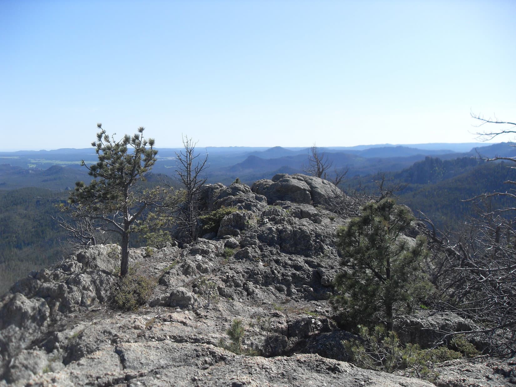
Meanwhile, the views were improving as Lupe gained elevation. Everything in the distance now looked familiar. Lupe was in one of the most rugged parts of the Black Hills here. Beautiful large granite formations were all around. Peak 6735 to the SW remained hidden from view most of the time, but Black Elk Peak(7,131 ft.) was often visible to the NW.
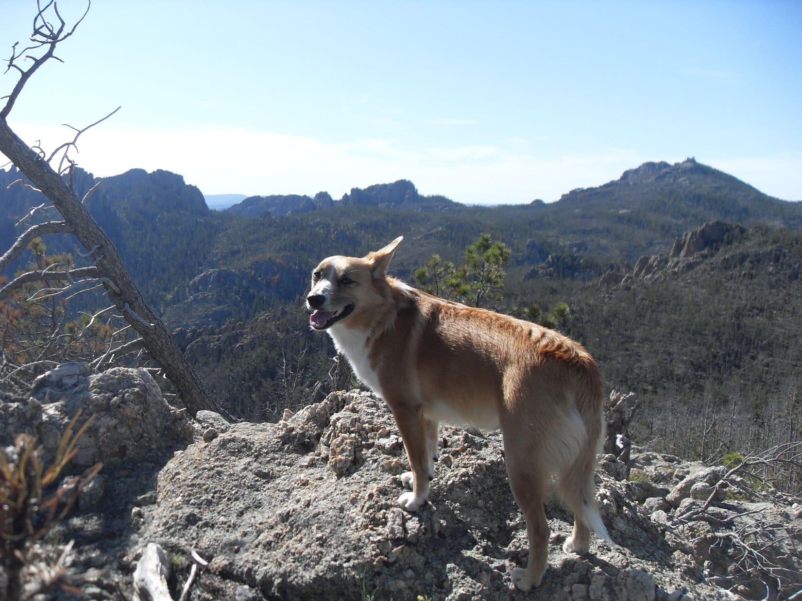
Yet another rocky high point on the ridge ahead. How many of these big rock formations would Lupe have to find a way past? SPHP couldn’t remember. Photo looks SW.Black Elk Peak (Center), the highest mountain in South Dakota, was often in view as Lupe climbed ever higher up the ridge. Photo looks NW.Lupe was in some of the most rugged country in the Black Hills. Photo looks NE back down the ridgeline she was coming up.
As expected, it finally happened. Lupe reached the top of High Point 6411. She’d had several water breaks on the way up, but now it was time for a longer break. Lupe had Taste of the Wild. SPHP ate an apple.
SPHP consulted the topo map. It seemed like it had taken a long time to get here, but Lupe had covered a depressingly short distance from Grizzly Bear Creek. On the bright side, she had gained a lot of the elevation required to reach Peak 6735. Unfortunately, she would have to give some of it back getting down off High Point 6411.
Since Lupe had come all the way to the top of High Point 6411, she might as well have a look around. Peak 6735 was in view, but still nearly a mile away.
Peak 6735 was in view from High Point 6411, but still nearly a mile of deadfall infested territory away. Photo looks SSW.At the summit of High Point 6411. Photo looks S.On Expedition No. 92, Lupe had come within 10 feet or so of reaching the summit of Peak 6710 seen here on the L. Parts of the Cathedral Spires and Little Devil’s Tower are in view farther off on the R. Photo looks WSW.Loopster at the very top of High Point 6411. Photo looks SSE.
The views were great from High Point 6411, but would be even better on Peak 6735. Onward! A first attempt to get down off High Point 6411 going WSW proved a little too steep for comfort. Ugh! Lupe climbed back up. SPHP couldn’t remember how Lupe had gotten down on Expedition No. 92.
A foray to the WNW didn’t look promising at first, but worked out just fine. Lupe made it down to the saddle leading to Peak 6710. Once across the saddle, she started climbing again. For a while, the terrain forced her to head directly toward Peak 6710, but this time she wasn’t going to go virtually all the way to the summit like she had on Expedition No. 92.
Once Looper made it past some more big rock formations, and was about as high as the saddle leading from Peak 6710 over to Peak 6735, she turned S and headed for the saddle. She wound up higher on Peak 6710 than she needed to be, but skirted the summit a little way off to the SE. Struggling through a thick forest of young pines choked with the endless deadfall, she finally got past Peak 6710. The saddle to Peak 6735 was now close by.
Once Lupe skirted around the SE slope of Peak 6710, the saddle leading to Peak 6735 was directly ahead. Photo looks S.
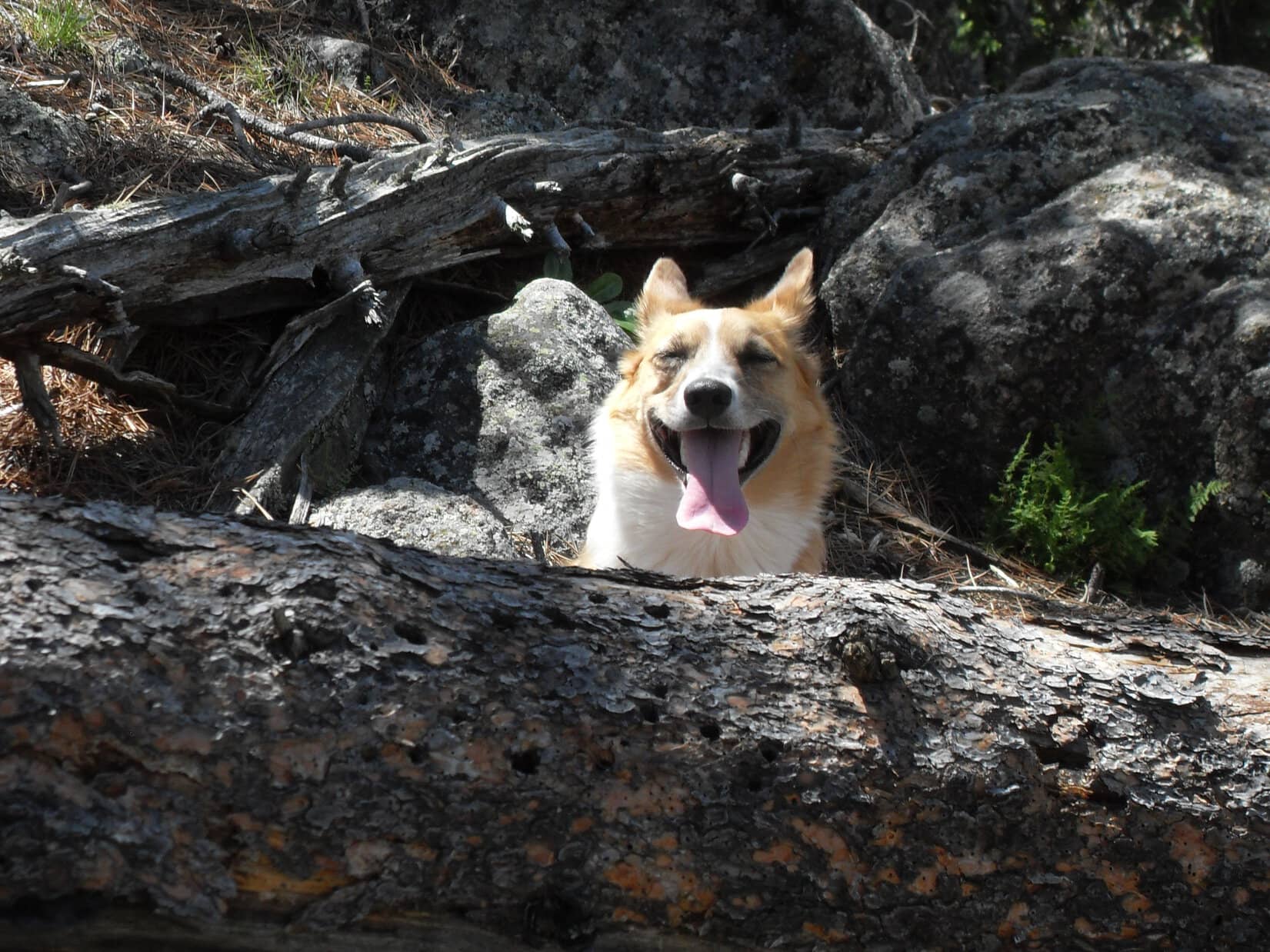
Across the saddle and straight up the N ridge. Lupe was getting close! Near the end, the terrain wasn’t as steep, the deadfall a little less troublesome. Suddenly Lupe was there! Despite the mountain’s deadfall defenses, the plucky Carolina Dog stood at the top of Peak6735.
Well, almost. A dead tree with many annoying branches was leaning against the very highest rock at the summit, preventing Lupe from getting up on it.
Oh, no! No way! Lupe had gone over, under, or around hundreds, maybe thousands, of dead trees to get here. The whole mountain was covered with and surrounded by wretched deadfall. All those jillions of dead trees could stay exactly where nature placed them, except this one. This one had to go!
Fortunately, the offending dead pine tree was smallish. SPHP managed to drag it away from the summit rock and push it over the edge. It fell only 10 feet, but at least it was out of the way. The summit rock was clear. Lupe stood on top!
After a long struggle through the deadfall, Lupe stands at the very top of Peak6735. Photo looks NW.
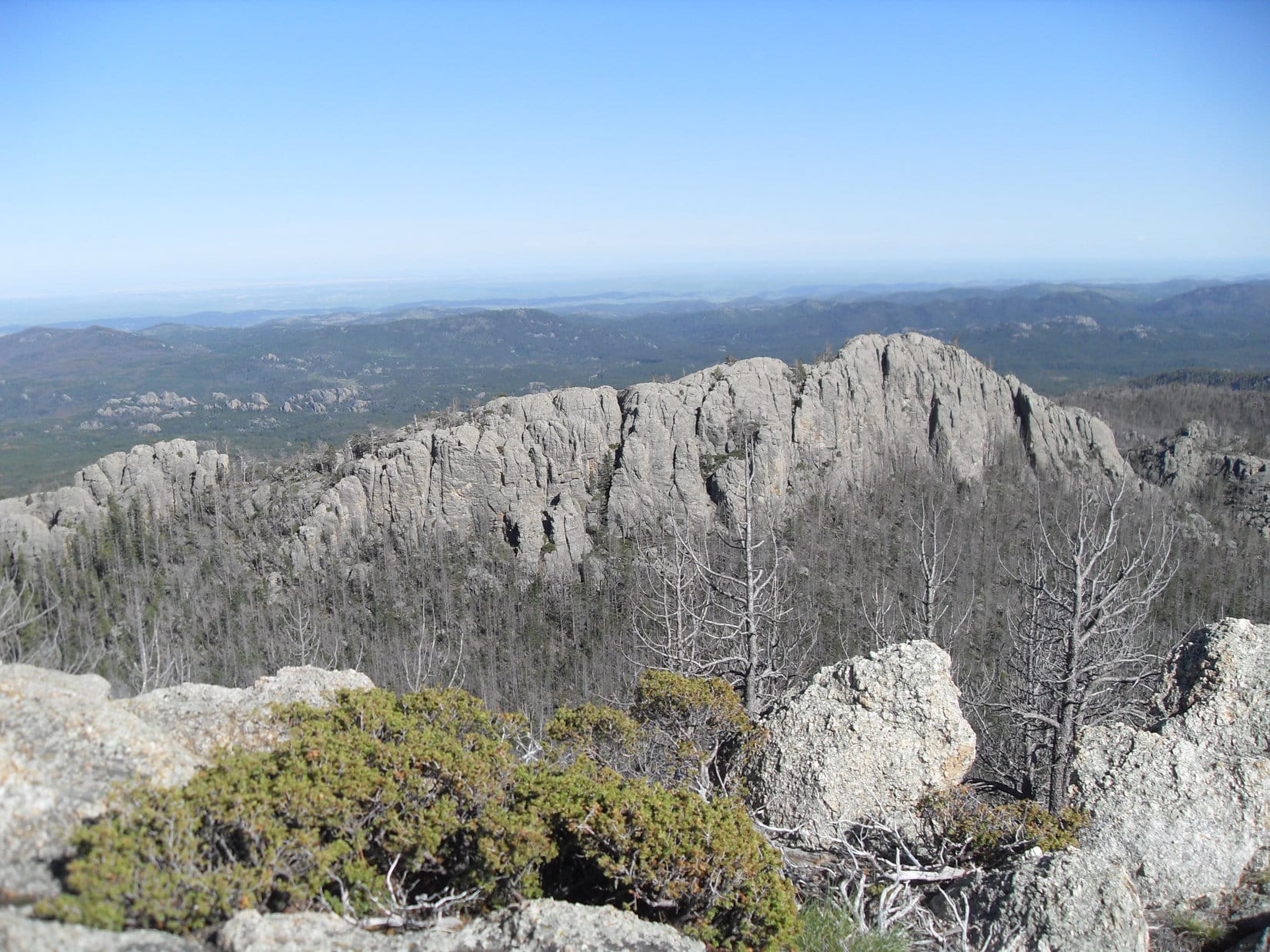
At the top of Peak 6735, a short uneven ridge of rock ran for 30 feet in a line oriented roughly E/W. The ridge sloped a little up toward a rock at the true summit near the E end. The greater summit area was much larger and sloped down toward the SW, where a massive, but lower, granite platform ran along the SE edge.
When Lupe had been here nearly 3 years ago on Expedition No. 92, Peak 6735’s summit had many large dead pines still standing. Some of them still were, but many had fallen over by now. The fallen trees made it harder to move around, but the views were more sweeping and open now than they had been back then. From seldom visited Peak 6735, Lupe had fantastic views of more than half of the entire Black Elk Wilderness!
After a suitably long rest break at the true summit, it was picture time. Naturally, Lupe toured the entire summit area.
Peak6920 (L) and Black Elk Peak(7,231 ft.) (R) from the true summit rock. Peak 6710 is the big rock formation to the R of Lupe’s head. Photo looks NW.Looking NNW. Black Elk Peak on the L.Looking E along the rocky summit ridge toward Loopster positioned at the very top.Another look at Loop at the top. Photo looks SE.Lupe found the cairn to her R sitting N of, and 8 or 10 feet below, the true summit of Peak 6735. SPHP hadn’t noticed any cairns when Lupe was here on Expedition No. 92, but maybe it was new since then? The large block of granite in the distance on the L is the back side of Mount Rushmore(5,725 ft.). Photo looks NE.Lupe now at the W end of the summit ridge. The highest point seen on the distant ridge at the far R is the top of Sylvan Hill(7,000 ft.). Photo looks WSW from the true summit.This photo shows a good deal of the greater summit area. Photo looks S.Lupe now along the SE edge of the greater summit area. Photo looks SSE.Looking SE.A glance back up toward the true summit. Photo looks N.Looking SW from the larger, but lower granite ridge along the SE edge of the summit area.Looper strikes a dramatic American Dingo pose. Photo looks NE back toward the true summit from the far SW end of the greater summit area.Looking S from the far SW end of the greater summit area.Much of the greater summit area. Photo looks NE from the SW end.Lupe near the true summit again after completing her tour. A lovely green carpet of kinnikinnick clings to a thin layer of soil. Photo looks NE.Back up on the little true summit ridge. Photo looks WNW.
Conditions were beautiful on Peak 6735. Lupe and SPHP lingered up here for quite a while, and would have loved to stay longer. However, even though the sun wouldn’t set for at least a couple of hours yet, it was time to go.
Already it was way too late to try to go back the way Lupe had come up. Traveling all that way through the deadfall took many hours. Getting stuck out here away from the trail when night fell would have made it nearly impossible to do anything other than wait for dawn. Even a deadfall-covered trail would be extremely difficult to follow at night.
On Expedition No. 92, Lupe had taken a shortcut back to Grizzly Creek Trail No. 7 by going around the E side of Peak 6710 and continuing N. This shorter route back down to the trail had been very steep, but had worked.
SPHP wondered if Lupe shouldn’t try to avoid such a steep descent this time? By heading beyond Peak 6710 towards Peak 6920, she wouldn’t have to lose much elevation before reaching Norbeck Trail No. 3 not too far from its junction with Grizzly Creek Trail No. 7.
The advantage was, this might be the easiest route out of here. The disadvantage was, Lupe had never tried it before.
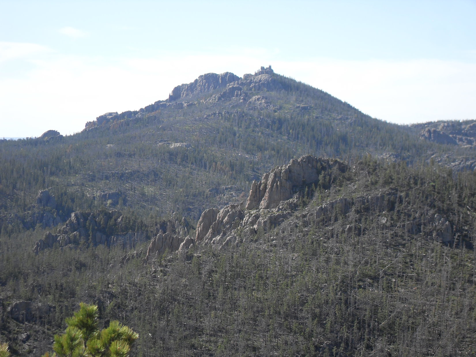
Lupe needed to get to a trail before dark, if she didn’t want to wind up stuck in all the deadfall all night long. SPHP pondered the possibility of heading W (L) of Peak 6710 (the lower rock formation on the R) and heading for Peak 6920 seen on the L. Lupe should reach Norbeck Trail No. 3 this way without having to lose a lot of elevation. Photo looks NW.
Lupe enjoyed a little more time up on Peak 6735 while SPHP pondered the best course of action.
Peak 6710 (L) with Black Elk Peak beyond it. Should Lupe try going around the W (L) side of Peak 6710? Photo looks NNW.The rugged terrain to the NNE. Lupe had come up from this direction, but there wasn’t enough daylight left to go back this way.The panorama to the NW. From L to R: Cathedral Spires, Little Devil’s Tower, Peak 6920, Black Elk Peak, Peak 6710.Last moments atop Peak 6735.High Point 6411 (lower R) is illuminated by sunlight. Photo looks NNE.
The final decision was made on the way down Peak 6735’s N ridge. Lupe would try going W of Peak 6710 and heading for Peak 6920. Hopefully, she would reach Norbeck Trail No. 3 well before sunset.
It was hurry up time, if possible, but the deadfall made the going dreadfully slow. By the time Lupe got over the ridge SW of Peak 6710, close to an hour had gone by. After crossing the ridge, the terrain and deadfall did not improve, but then they weren’t expected to. The only solution was to get to a trail. Any trail would do.
Looking up at the rock formations Lupe traveled beneath W of Peak 6710. Photo looks E.Looking back at the big rock formation at the far end of the ridge extending SW from Peak 6710. Photo looks S.A closer look with help from the telephoto lens.
Once she was over the SW ridge, Lupe lost some elevation before having to regain it to get up on the next ridge to the NW. This ridge went W from Peak 6710. Lupe and SPHP followed it a short distance, but within 5 or 10 minutes it was apparent a deep valley was ahead. This wasn’t going to work. Where to now?
Loop started back E toward Peak 6710. SPHP noticed a saddle off to the NE. It led to the NW, the way Lupe needed to go, and was every bit as high as where she was now. That was the route! Puppy, ho! Lupe maintained elevation and headed for the saddle.
It took a good 10 minutes to get there. The saddle wasn’t terribly wide or long. It led to a large rock formation immediately to the WNW. Climbing up there looked possible, but time consuming. Instead, Lupe crossed the saddle and turned NW to go around the high point.
Lupe was now way up in the upper Grizzly Bear Creek drainage. Somewhere down below was Grizzly Creek Trail No. 7. For a while, Lupe tried simply maintaining elevation and going NW. The plan was still to look for Norbeck Trail No. 3. A high ridge came into view to the NW. That had to be where Norbeck Trail No. 3 was, but it was still a considerable distance away and a bit of a climb.
SPHP debated whether Lupe should try simply cutting down through the forest directly to Grizzly Creek Trail No. 7, or getting on top of the ridge she was following? She tried a little of both, but didn’t lose all that much elevation going down, and never made it all the way to the top going up, either. The varied terrain kept changing SPHP’s mind on which way she ought to go.
A 50 foot deep ravine appeared ahead. Lupe had to kept going NW, so there was no choice, but to go down into it. Loop led the way down the slope. Suddenly SPHP realized she was standing on a trail! Odd, surprising. SPHP hadn’t thought she was anywhere close to a trail yet. Whatever works, though! The trail was good news!
The trail Lupe had found had to be Grizzly Creek Trail No. 7. SPHP wondered how far Loop was from the intersection with Norbeck Trail No. 3? Didn’t matter. The sun would still be up for a while. Best to make tracks, and use the available daylight to get past as much deadfall on the trail as possible. Without the slightest hesitation, Lupe and SPHP followed Grizzly Creek Trail No. 7 going E.
The sun was still shining on the high peaks and would be for a while, but Lupe had a lot of elevation to lose. The trail went on and on. Fortunately, this upper section of Grizzly Creek Trail No. 7 trail was not choked with deadfall. In fact, there was very little of it. Lupe made great progress, but the sun had set by the time she made it all the way down to Grizzly Bear Creek.
Lupe makes it back to Grizzly Bear Creek.
The trail crossed Grizzly Bear Creek a number of times, but the creek was low enough so the crossings weren’t a problem. Deadfall on the trail became a problem again and slowed things down, but was no big deal compared to what Lupe had been through already.
The forest was dim and the sky pale, by the time Lupe reached the intersection with Horsethief Lake Trail No. 14 again. The race to make as much use of the fading light as possible continued. Lupe didn’t stop for a break until she was beyond the upper pass. SPHP could hardly see the trail now. The flashlight came out.
Stars had been shining above for a while. No worries, though. Lupe knew the rest of the trail ahead had little deadfall. It would be easy enough to follow.
A short break, then onward, but now at a relaxed pace through an inky black forest with incredibly bright stars above. What a gorgeous evening!
Well, Looper, Expedition No. 200 wasn’t a bad day’s adventure, was it?
No, not at all, but I still say it needed more squirrels!