Squaretop Mountain, Wind River Range, Wyoming – Part 2: Beaver Park to the Summit (7-21-18)

Days 9 & 10 of Lupe’s 2018 Dingo Vacation to the Bighorn Mountains & Wind River Range of Wyoming!

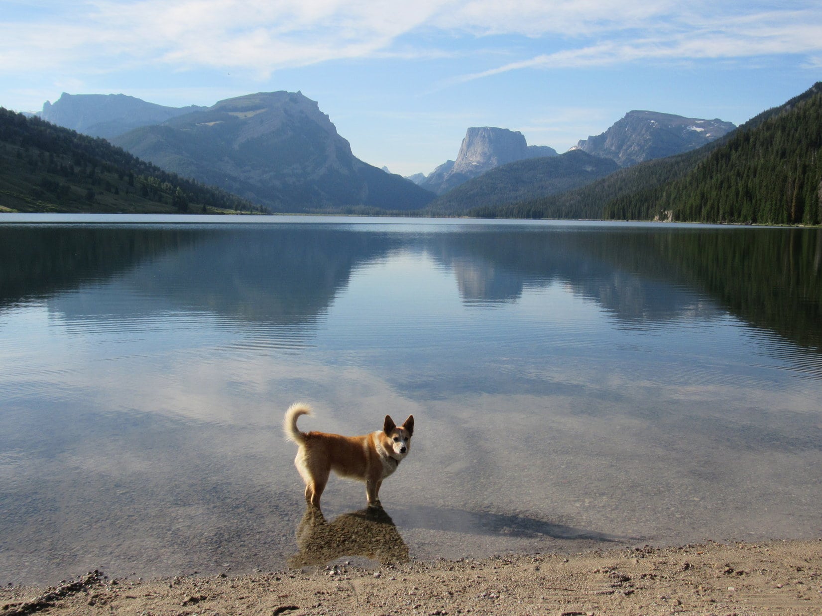
7-21-18, morning, Beaver Park – Yesterday’s march in from Green River Lakes had been tiring.  Despite having crawled into Lupe’s new Marmot tiny house early, and having slept well, the sun was up again long before Lupe and SPHP reemerged.

Not good.  Not good at all.  Looper hadn’t made it up to her intended base camp at Granite Lake yesterday evening.  And now a late start from Beaver Park.  This was the critical big day, too!  Perhaps Lupe’s last chance to ever get to the top of Squaretop Mountain (11,695 ft.).

Lupe and SPHP went over to meet the neighbors.  John and Lisa were camped on the only truly dry ground in Beaver Park at a small grove of big pines near the S end.  Loop had seen their tent yesterday, but they hadn’t been around then.

Turned out John and Lisa had gone off climbing the big ridge to the W looking for Granite Lake.  They hadn’t found any consistent trail up, but had made it to a forested high point on top of the ridge.  They hadn’t seen any sign of Granite Lake, though.  Without a map, they’d had no idea which way to go looking for it, either, so they’d just come back down.

John and Lisa were from Illinois.  They said they had been coming to camp for a week at this exact same spot in Beaver Park every year in late July for years now.  Best week of every year – they loved the Wind River range!  They’d been here a few days so far.  Lots of people came and went.  Many stopped by to ask them how to get to Granite Lake, or where the route up Squaretop Mountain was, but they really didn’t know.  All they really knew was that very few of the people they talked to ever made it to Granite Lake.  A teeny tiny minority succeeded in climbing Squaretop Mountain.

Squaretop Mountain Route … The route on up to Square Top is not difficult.  The smallest child I ever took up there was 4 years old, but you have to hand him up over the ledges in a lot of places.” – Finis Mitchell in Wind River Trails

About the time the conversation with John and Lisa was winding down, a dozen young men and teenagers emerged from the forest over by the ridge W of Beaver Park.  SPHP talked to several of them as they came by.  They had been camped up at Granite Lake the past 2 nights.  Yesterday, every one of them had made it up Squaretop Mountain!  Only took 3 hours to summit from the lake.

One of the men had a GPS track of the route they’d taken.  The screen was small and hard to see in the morning sunlight, but the glimpse SPHP got looked like they had gone W from Granite Lake, turning more NW as they got higher.  The whole group was enthused by their success.  They marched off to the Highline Trail and disappeared, apparently intent on returning to the trailhead at Lower Green River Lake.

A shame they had all left so quickly!  SPHP would have liked to have learned more about their route, and what they’d encountered.  Still, this was certainly good news.  Sounded like they had done exactly what Lupe intended to try based on Finis Mitchell’s account in Wind River Trails.

Better get on with it, too!  9:30 AM already.  John and Lisa wished Lupe success, then she headed NW across Beaver Park for the 1200 foot high W ridge where Granite Lake lay hidden above.

Starting for Squaretop Mountain (L) from Beaver Park. Granite Peak (9,892 ft.) (R). Photo looks NW.

Granite Lake Trail – A short distance after crossing the bridge a faint trail takes off to the right with a sign showing the Granite Lake Trail.  This trail, an old horse trail, is very difficult to follow unless you’ve had a lot of mountain experience.  In 1953 there was a big forest fire here.  It burnt the whole side of the mountain and it’s still the mess that it was when the fire went out.” – Finis Mitchell in Wind River Trails

Squaretop Mountain Route – If you want to climb Square Top, after you cross the foot bridge on the Green River you go about 150 feet out into the woods and you come into the upper end of a big park.  You go over to the edge of the timber and follow it down until you get down to and beyond the forest fire and downed timber.  Then there is a draw comes right down from Granite Lake to the river, with green live timber in it.  You work your way up the draw, past the burned area and pick up the old horse trail and go on to the lake …” – Finis Mitchell in Wind River Trails

No doubt it all made perfect sense back in the 1970’s when Wind River Trails was published.  However, Loopster hadn’t seen any signs for the Granite Lake trail, and in the 65 years since the forest fire, the forest had regenerated to a point where no burn area was visible.

No worries, though.  The topo map was crystal clear.  All Lupe had to do was head WNW up the 1200 foot ridge staying S of Granite Peak.  Once the terrain leveled out, Granite Lake ought to be close at paw.  Simple enough.

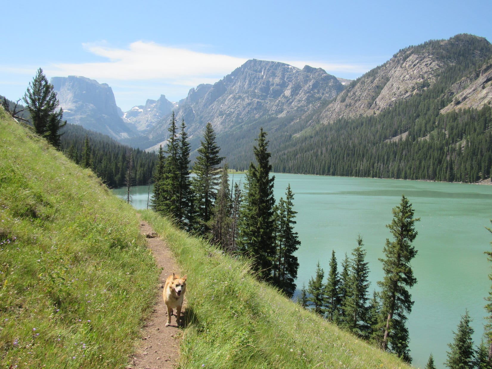
Nearing the timber, Lupe crossed a boggy area, then a mucky little trickle of a stream at the base of the big ridge.  Any ravines or old trails were still probably farther N than where Lupe was.  SPHP didn’t bother looking for them.  The Carolina Dog went right up into the forest, and started a long climb.

The slope was uniformly steep; wearying, but not dangerous.  For a long way, the forest hid all views.  Deadfall timber was present, but usually not that much.  Lupe came to no major rock outcroppings or cliffs.  The slope simply went up and up, with little variation.  SPHP tried to angle NW, thinking Lupe was farther S than Mitchell’s recommended route.

On the way up the 1200 foot ridge W of Beaver Park. Photo looks S.

Loop was making good time going up the ridge, limited only by SPHP’s heart, lung and leg capacity.  She was already quite high when she came to a clearing.  Although the morning had started out sunny with bright blue skies, by now it had clouded up.  A light rain began to fall.  SPHP stopped to don the old blue plastic rain poncho.

The clouds didn’t look all that threatening.  Lupe continued climbing.  She stayed in the clearing – a long, skinny, continuous strip that went W straight up the ridge nearly all the rest of the way to the top.  The rain subsided, and SPHP stopped again to remove the poncho.

Following the clearing higher. Photo looks WNW.
From the clearing, Lupe had steadily improving views of the Green River valley, though the river itself could not be seen. Photo looks SE.

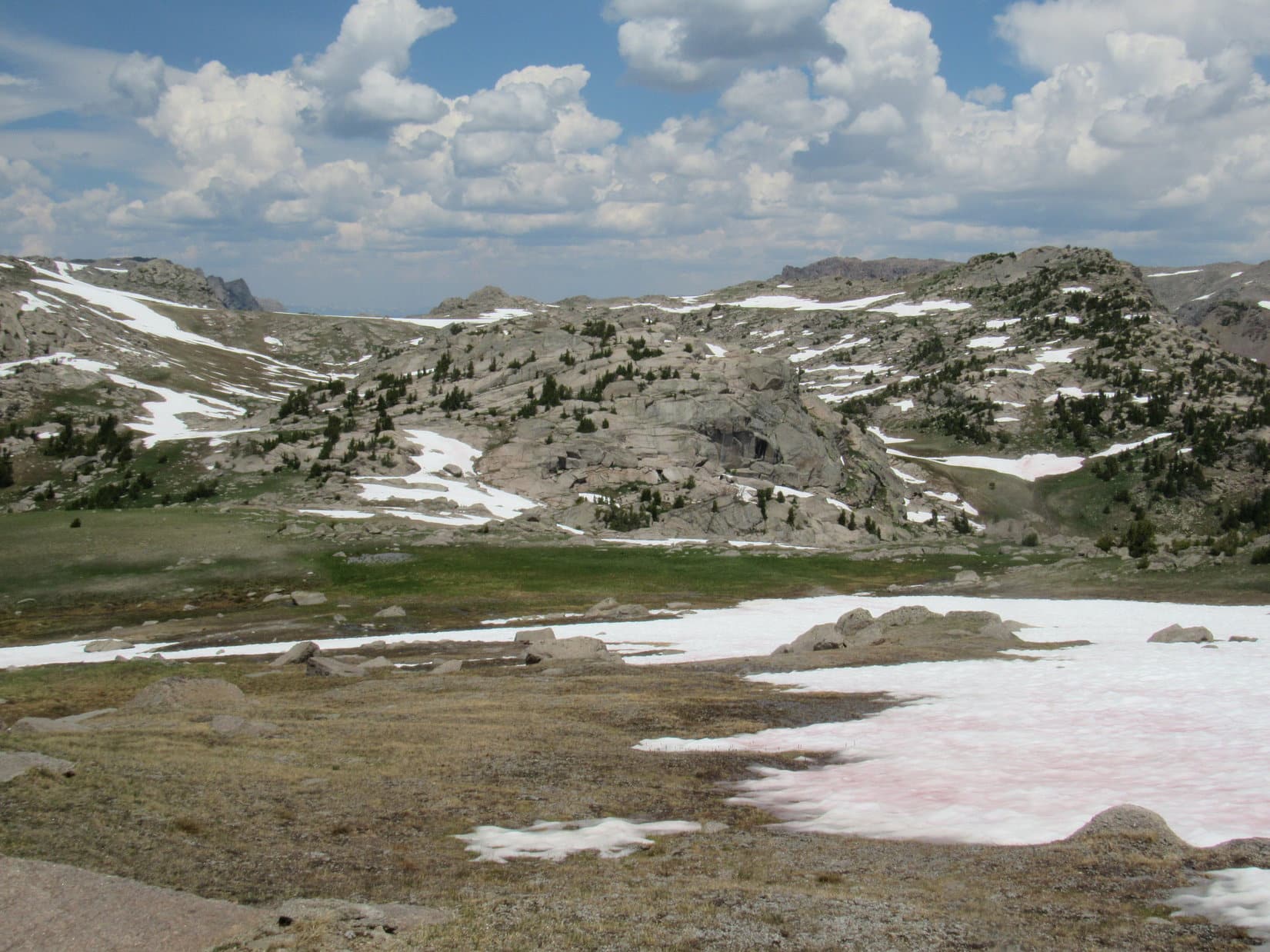
Two hours after leaving Beaver Park, Lupe reached the top of a hill.  This seemed to be the high point of the entire 1200 foot ridge.  The clearing had ended shortly before getting here.  The hill was all fairly open forest, with lots of sizable deadfall timber scattered around.

Lupe had no unobstructed views, but by moving about, much of the E face of Squaretop Mountain could be seen between the trees.  A glimpse of Granite Peak was visible off to the N, but Granite Lake was not in sight.  SPHP studied the views, comparing them to the topo map.

This was probably the same hill John and Lisa had made it to yesterday.  Minus a map, they hadn’t known which way to go from here to get to Granite Lake.  However, SPHP was just about certain where Lupe was.  This hill had to be High Point 9385.  The S end of Granite Lake was only 0.25 mile NW.

At High Point 9385, a hill at the very top of the 1200 foot ridge. Photo looks SW.
Granite Peak (L) from High Point 9385. Photo looks N.

Squaretop Mountain Route … You go right around the right hand side of the lake to the outlet and cross (no trouble crossing).  You go back around the lake part way and take up a little tiny stream that comes off of Square Top.  You follow that stream clear up till you get above timberline, crossing a lot of snow.  There’s a break in the ledges and you can go clear to the top.” – Finis Mitchell in Wind River Trails

Hmm.  SPHP was surprised Lupe was still as far S as High Point 9385.  The outlet stream Mitchell said to cross was way over at the N end of Granite Lake more than 0.5 mile away.  Furthermore, she was already 140 feet higher than the lake.  No doubt Mitchell was the expert, he’d spent nearly his whole life in the Wind River range.  Maybe, though, there was a closer alternate way up?

A giant cirque S of High Point 11383 way up on Squaretop Mountain was partially in view.  The topo map made it look like the cirque might not be as steep as Mitchell’s route farther N among the ledges.  The last few hundred feet to the top looked challenging, but maybe it wasn’t all that bad?

Part of what SPHP suspected was the area of Finis Mitchell’s route was also in view.  The upper end of it looked challenging, too.  Was it really any better?

The giant cirque (Center) S of High Point 11383 (R) from High Point 9385. Photo looks WSW.
The upper end of the cirque S of High Point 11383 with lots of help from the telephoto lens. Photo looks WSW.
As SPHP understood it, Finis Mitchell’s route up Squaretop must be in the area near the center of this photo. Photo looks NW from High Point 9385 with help from the telephoto lens.

The giant cirque was closer, but not a proven route.  The safest choice, with the highest likelihood of success, was for Lupe to go find Granite Lake, then follow Mitchell’s instructions as precisely as possible.  Those happy young guys Lupe had met down at Beaver Park this morning had apparently done just that.

Maybe it was the lack of oxygen in the thin mountain air?  SPHP led the Carolina Dog toward the giant cirque.

Traveling SW through the forest from High Point 9385, Lupe came to a boggy clearing rich with tall green grasses.  She stayed N of the clearing going W.  Loop had lost only minor elevation coming down off High Point 9385 to this saddle area.

At the rich green boggy clearing WSW of High Point 9385. Photo looks SW.

As Lupe got closer to Squaretop Mountain, she eventually turned NW to look for the inlet stream that comes down to Granite Lake from the giant cirque.  SPHP thought the American Dingo might be able to follow this stream up into the cirque.

In fact, in SPHP’s mind, Finis Mitchell’s brief description of his route up hadn’t entirely excluded the possibility that he actually did mean to take this same inlet stream up into the giant cirque.  He never actually came out and said that, though, which he likely would have if that had been the case.

When Lupe reached the inlet stream, what she saw fairly conclusively ruled out this possibility.  Mitchell had described the stream to follow up the mountain as “tiny”.  The inlet stream wasn’t huge, but had decent flow.  Furthermore, it was braided with a number of channels, some widely separated, taking different courses down the mountain.

After a climb in the forest and passing through a rocky area going NW, Lupe reached this slope where the inlet stream to Granite Lake poured down from the giant cirque in a number of different channels. Granite Peak (R). Edge of Squaretop Mountain (L). Photo looks N.
One of a number of similar channels of the Granite Lake inlet stream.

SPHP thought it best to cross over to the N side of the inlet stream, so one by one, Lupe crossed the various channels.

Loop about to cross another channel.

As Lupe worked her way higher, the stream became more concentrated, the separate channels starting to combine into a single course.  Loop was climbing fairly steep slopes that were partially forested, and part open meadows filled with wildflowers.

Looking higher from just N of the main stream course. Photo looks W.

After a good climb, it appeared Lupe was approaching the base of a rock ledge or line of small cliffs.  SPHP could find no break in this formation.  Looper was forced S.  She ultimately gained the top of the ledge by climbing a series of little waterfalls right up the main stream bed.

Approaching a line of small cliffs. Lupe was forced to climb right in the stream bed (L) in order to get up on top. Photo looks W.

Above the ledge, the terrain was still steep.  Lupe stayed farther N again, as she worked her way W through mostly forested territory.  She gained substantial elevation.  The views back to the E and SE of the Green River canyon became ever more spectacular, though the valley floor down by the river still could not be seen.

Heading higher somewhere above the line of small cliffs. Photo looks SW.
Among the wildflowers.
Approaching rockier terrain. Photo looks NW.

On and on!  The American Dingo kept climbing.  Staying N of the stream, she made steady progress toward the giant cirque.  The forest thinned out.  The terrain became rockier.  Lupe started coming to large boulder fields more and more often.  The views opened up.

Hey, looky here! Now we’re starting to get somewhere! Photo looks WSW.
Giant cirque S of High Point 11383 dead ahead, I do believe! Photo looks WSW.
Entering the E end of the giant cirque. Photo looks SSW.
Looking up at what was directly above. Lupe would stay S (L) of the high point at Center. Photo looks NW.
Looking back down at the Green River canyon. Photo looks SE.
Whew! It’s farther than it looks, but we’re getting there! Photo looks SW.

As Lupe got higher and farther W into the giant cirque, SPHP expected to see some fairly easy routes up out of it along the upper edge.  At first this seemed to be the case.  However, as Looper got even closer, SPHP began to realize that all the channels or gullies leading to the upper lip of the cirque seemed to be full of snow at dangerously steep angles, far steeper than Lupe and SPHP were prepared to deal with.

SPHP began scrutinizing all the cliffs along the upper edge of the cirque.  Which way?  Where should Lupe go?  At the far SW end were several gullies that looked fairly promising.  It appeared there might be a route over there where only a short section of snow would have to be crossed where there was exposure.  However, that area was farthest away from where Lupe was now, and time was already a consideration.  Who knew what it all actually looked like up close?

Loop was closest to a big gully on the R (N).  SPHP had great hopes for it, but as the Carolina Dog approached, those hopes were dashed.  Way too steep.  Too much snow.

As Lupe got closer to the W end of the huge cirque, SPHP scanned the cliffs along the upper edge looking for a way up. The area seen directly beyond Lupe seemed to hold promise, but was farthest away. Photo looks SW.
Another look back at the Green River canyon from higher up. Photo looks SE.

Lupe kept climbing.  As the perspective changed, SPHP kept scanning for possibilities.

Looking W.
The most intriguing possibilities are on seen on the L, but getting over there would take some time. Photo looks SW with help from the telephoto lens.
Getting closer to the first big gully (Center) that didn’t pan out. Photo looks W.
Checking out that upper SW end of the cirque again. Photo looks SW.
Zoomed in on the upper W end of the cirque where a stream plunged down in a series of small waterfalls. Photo looks WSW.

The next gully W beyond the first disappointing one on the R (N) looked like a decent option.  It was narrower, and had a steep snow bank in it, too.  However, it appeared Loopster could go up a 2 or 3 foot wide gap between the snow and the rock wall to the SW.  She ought to be able to get high enough in this manner to reach a point where she could leave the gully, and have an easy climb the rest of the way up.

Approaching the next promising nearby possibility. Photo looks WNW.
OK, this might be the way! Going to try staying in between the rock wall and the L side of the snow bank. Photo looks NW.

By the time Lupe reached the bottom of the snow bank, it was clear this gully and the snow bank were much steeper than they had looked from below.  However, it was possible to go carefully up the gap between the snow and the rock wall to the L.  Loop did manage to get as high as it looked like she would have to before leaving the gully, but the escape route proved to be an illusion.

No way!  Ahead the rock wall protruded against the snow, completely closing off the gap Lupe was climbing up, and any possibility of going higher without actually getting up onto the snow.  As steep as the snow bank was, that was completely out of the question.  Failure!

SPHP was ready to start a careful descent, when out of the corner of an eye, there was movement to the R.  Lupe!  In horror, SPHP glanced over to see her standing quite happily a few paces away right up on the snow.  Apparently she had realized that she had to get up onto it in order to go any higher.  Somehow she had done so of her own volition.

In horror, SPHP realized Lupe was standing out of reach on the perilously steep snow.

Lupe stood smiling proudly at SPHP.  She was ready to keep going!  If she lost her grip, though, and started to slide, there would be no stopping what would happen next.  A 75 to 100 foot rocket slide straight down the chute to be dashed onto to the jagged rocks below!

Looking down the Gully of Death.

Come, Lupe!  Come here, girl!  Come!  Come to me!

Lupe did.  A couple of steps and she was within reach.  SPHP grabbed her collar and yanked her to safety.  Dodged a bullet!  Gonna be OK.  That careful retreat now began.  No more getting up onto the snow!

Time consuming, but Lupe made it safely down out of the Gully of Death.  SPHP began leading her toward that most promising area way over to the SW.  Lupe hadn’t gone far, however, when it looked like she might be able to simply scramble directly up the rocky slope just above her.  Didn’t look far to some ledges and easier terrain above.  Why not?

Another illusion was why not.  Once Lupe started up, it became clear this route was much steeper, and safety much farther and higher, than it had first appeared.  Exposure!  SPHP hates exposure!  The route kept threatening to end abruptly.  Many times SPHP managed to creep, crawl, or climb higher wondering if Lupe stood any chance of following.  As if by magic, the Carolina Dog always did.

What had appeared to be a 40 or 50 foot climb, turned out to be more like 200 or 300 before Lupe finally got to where the situation improved, and SPHP was certain the scary part was over.  Never again!  SPHP resolved Lupe would find another route for her descent.  The thought of ever coming back down this way was petrifying.

Loop relaxing after a nerve-wracking ascent of the steepest part of her route out of the giant cirque. Photo looks SE.

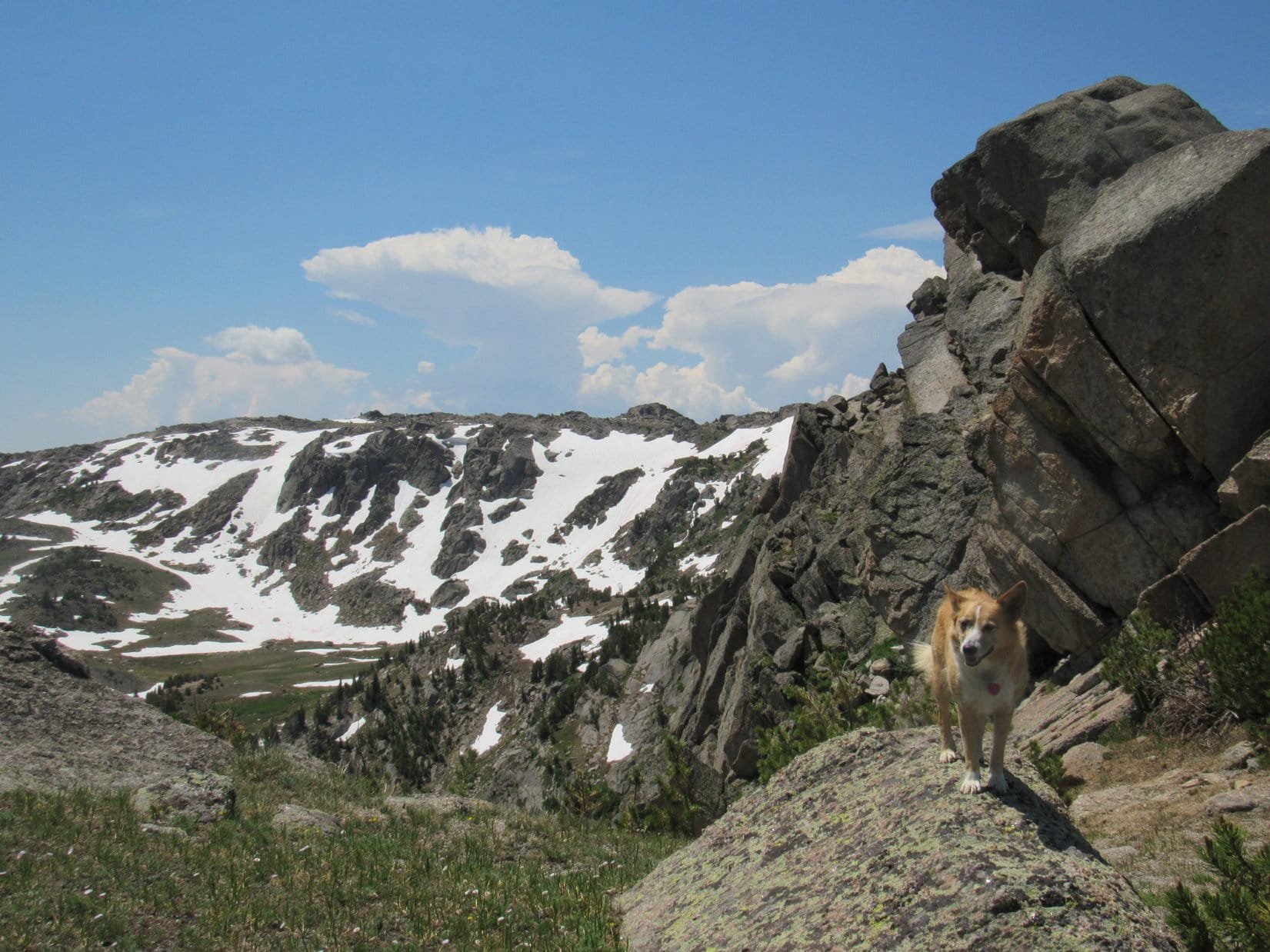
Lupe still had another 300 or 400 feet higher to go to completely escape the giant cirque, but the worst was over.  Still a very steep trek at first, the slope of the terrain steadily decreased.  Loop was on vegetation now.  The ground wasn’t so rocky.  She started having fun again roaming W, while leading the way up along the N side of a big ravine.

Looking back down. Lupe’s route higher was still very steep at first, but the worst was over. Photo looks SE.
Oh, yeah! Looking better now! Photo looks SSE.

A stream full of tiny waterfalls flowed E down the center of the ravine.  Lupe came to multiple false summits as she sniffed and explored higher.  The slope of the terrain kept decreasing.  Couldn’t be much farther!

Lupe (Center, R of the closest snow) leads the way up the big ravine. Photo looks W.
Out of the giant cirque at last, along the upper edge. Photo looks SE.

Finally!  Loopster was out of the giant cirque!  She stood at 11,000 feet, nearly 3,000 feet higher than where she’d started the day back at Beaver Park.  She had reached Squaretop Mountain’s huge summit plateau, but was still a long way S of the actual true summit, nearly 700 feet higher.

Squaretop Mountain Route … When you get out on top, then in order to look back down to Green River Lakes (you’re on the rear end of the top) you have to go about a mile and a half over the top to where you can look back down over the lakes.  From the main trail it’s a couple of miles to Granite Lake, then about another mile to the top.  On the top you don’t have to go clear to the front to get a good view.  You can stay along the right side and go out on points where you can see the river and your trail all the way up.  You can turn around when you get on top and see clear back to Gannet Peak and a lot of the glaciers.  You’re at 11,695 feet, about three and a half thousand feet above the river …” – Finis Mitchell in Wind River Trails

The topo map disagreed with Mitchell’s distances, but his elevations were spot on.  So was the overall gist of his description of the layout.  Lupe needed to head N.  The true summit was still a mile away as the crow flies.  Though hours of daylight remained, it was clear she would be pressed for time on the return.  Loop had to go even farther N than the summit in order to look down upon the Green River Lakes.

Didn’t matter how long it was going to take.  Though unprepared, even if it meant having to stay up on Squaretop overnight, the American Dingo was going to get there.  Not coming this far only to beat a retreat!  After pausing a few moments to enjoy the thrill of having escaped the giant cirque, Lupe headed N.

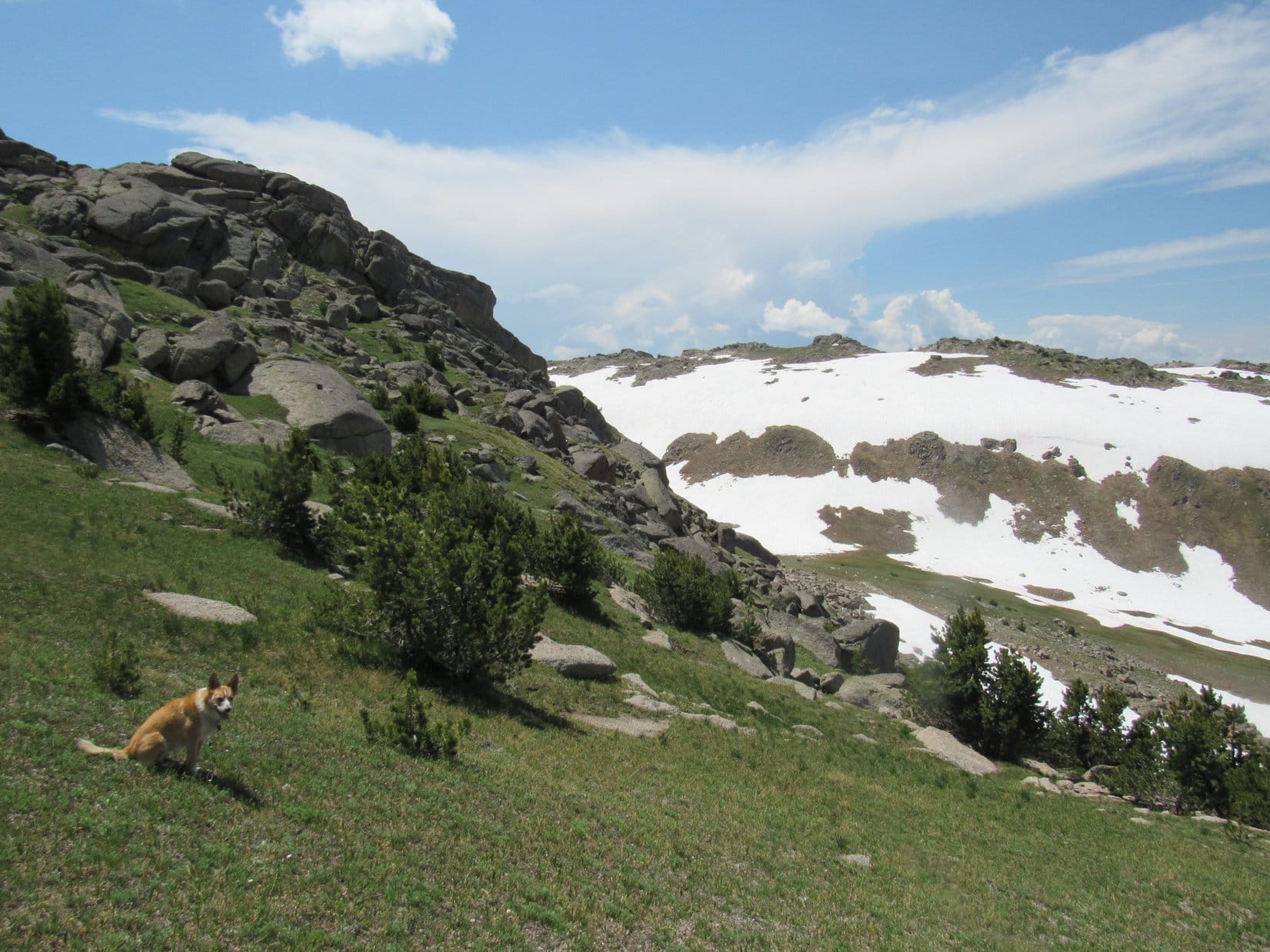
Before her was a broad plain strewn with numerous low-lying boulders.  Beyond this plain were flat-topped ridges of rock a few hundred feet high.  A wonderful, easy romp was ahead all the way to those rocky ridges.

On Squaretop’s summit plateau after escaping the giant cirque. A wonderful, easy romp was ahead. Photo looks N.

0.33 mile N got Loop close to the first of the rocky ridges.  The plateau was still broad here, but narrower than before.  A wide lane of alpine meadow along the E side was clearly the easiest way forward.  Lupe passed near large snow banks to the W from which tiny meltwater streams trickled down through the meadow and over the E edge.

Were these snow banks the source of the tiny stream Finis Mitchell said to follow up from Granite Lake?  SPHP was convinced they were.  If so, Mitchell’s route must reach the summit plateau in this area.  This theory seemed more than plausible.  Unfortunately, Lupe couldn’t afford to waste valuable time further investigating this possibility.

Lupe (R) leads the way past the snow banks W of the alpine meadow. This meadow may be where Finis Mitchell’s route reaches the summit plateau. Loop is headed for the E (R) end of the rocky ridge just ahead. Photo looks N.

The Carolina Dog continued on.  Before getting very far beyond the snow banks, the first rock ridge extended almost all the way to the E edge of the mountain, choking off the alpine meadow.  Lupe began climbing, and soon made a significant discovery.  Cairns, and a faint trail!  More evidence that Mitchell’s route did come this way.

Looking back from the ridge, Lupe had a better view of the area where Mitchell’s route probably came up.  From the alpine meadow, the terrain sloped ever more steeply down to the E seemingly destined for a plunge into an unseen abyss.  Of course, if that actually was Mitchell’s route, the appearance had to be deceiving.  Still, the unnerving scene did not make SPHP want Lupe to consider a descent that way on her return trip.

Starting the climb up the first rock ridge of the summit plateau. Photo looks S back the way Lupe had just come. The alpine meadow from which tiny streams trickle down to the E (L) is at Center. Mitchell’s route seemingly must come up from the ravine on the L.
Looking SE now from the same spot. If SPHP was right, Mitchell’s route continues down toward the lower L. Yikes!
Gannet Peak (13,804 ft.) (Center) from the same spot. Photo looks SE.
Cliffs along a notch in the E face of Squaretop Mountain. Green River valley below on the R. Photo looks NNE.

Lupe climbed NW, and reached a less rocky area N of the first ridge.  A big notch coming in from the E face of Squaretop forced her to continue W or NW.  A few minutes brought Loop clear over to Squaretop’s W edge for the first time.  Here she could see partway down into the Marten Lake canyon, although she wasn’t close enough to the edge to see all the way down to the lake.

Of more interest was the view to the SW.  Off in the distance, there was New Benchmark (11,850 ft.)!  New Benchmark was the very mountain where Lupe had been stymied by a huge steep snowbank that prevented her from continuing toward Squaretop Mountain from the W in 2017.

Near the W edge looking over the Marten Lake canyon. New Benchmark is the high point in the distance farthest R near Center. Photo looks SW.
Peak 11,820 (L) and New Benchmark (R). Photo looks SW with lots of help from the telephoto lens.

Having reached the W edge, the terrain now favored climbing back to the NE.  Lupe came to a succession of relatively gently sloping rock strewn meadows where she made rapid progress.  However, each meadow led to a much steeper, slower climb up a bouldery ridge.

One of a series of alpine meadows each leading to steeper climbs up boulder ridges. Photo looks N.
Tiny wildflowers decorated the meadows.

After traversing several such meadows and ridges, a notable high point was seen ahead.  A collection of large boulders forming a wall 25 or 30 feet high sat perched upon the largest ridge yet near the E edge of the mountain.  Was that the summit of Squaretop Mountain (11,695 ft.)?  Lupe headed toward it.

Approaching what SPHP thought might be the true summit. Photo looks NE.

No!  As Lupe scrambled up onto the ridge, a clearly higher collection of boulders was seen farther N.  That was it, no doubt about it – the true summit of Squaretop Mountain!  Lupe was almost there!

Approaching the true summit of Squaretop Mountain (Center)! Photo looks N.

The true summit was 500 feet farther N, sitting out on a flat plain full of rounded boulders far from any edge of the mountain.  The boulders weren’t numerous enough to seriously impede progress.

Ignoring the first high point she was already practically right next to, Lupe took off for the summit.  She scrambled to the top from the W end in a flash.  Easy, squeezy!  Nothing to it!  SPHP soon joined her.

Lupe reaches the true summit of Squaretop Mountain. Photo looks SE.

Another similar collection of boulders sat even farther off to the N across the bouldery plain, but it was clearly lower.  Lupe was definitely at the true summit.  SPHP searched, but found no survey benchmark or registry.  Only a pathetic little excuse for a cairn marked the top of mighty Squaretop Mountain (11,695 ft.).

Even farther N across the bouldery plain sat yet another similar collection of boulders forming yet another high point, but it was clearly lower. Photo looks NW.

Nothing impeded the views from Squaretop Mountain’s true summit.  In nearly all directions Lupe saw a grand assortment of tremendous peaks.  The most impressive lay mostly along spine of the Wind River Range off to the SE, where Gannet Peak (13,804 ft.), highest in Wyoming, and many others SPHP didn’t recognize were on display.

Lupe’s L ear (seen on the R) points up toward Gannet Peak. Photo looks SE.
Gannet Peak (L), the Wyoming state high point, from Squaretop Mountain. Photo looks SE with help from the telephoto lens.
Same view with Gannet Peak on the L, but with less help from the telephoto lens. Photo looks SE.
Gannet Peak (Center) and others along the spine of the Wind River Range. Photo looks SE.
Zoomed in on Peak 11,820 (L) and New Benchmark (R). Photo looks SW.
New Benchmark (11,850 ft.) (Center) far beyond Lupe. Photo looks SW.
Gannet Peak at far R. Photo looks ESE.
Looking SSE with lots of help from the telephoto lens.

Time was running out.  Yet there was more to see from Squaretop, lots more.  Due to the late start and all the other mistakes SPHP had made, Lupe only got to spend 15 or 20 minutes at the true summit before she really needed to be moving on.  She had her peakbagging achievement, but still had not seen the premier view that makes Squaretop Mountain such an incredible destination.

She still hadn’t seen the glorious view looking back down the Green River canyon all the way to the Green River Lakes.

SPHP scrambled down first.  For several magical minutes the Carolina Dog remained alone atop the true summit of Squaretop Mountain.

Lupe alone at the true summit. Photo looks E.
Hard to believe I’m finally really here!
Last moments awaiting the signal to come down.

SPHP signaled.  Lupe raced down.  Puppy, ho!  On to the next cluster of boulders to the N!  May as well check it out.  It was on the way to those fabulous, long highly anticipated views of the Green River Lakes.

The next cluster was actually a somewhat trickier proposition.  The top was narrow and a bit precarious.  Another cairn was up here.  However, a glance back to the S only served to confirm that the true summit really was back there.

Loop atop the far N high point. SPHP remained of the opinion that this was not the true summit. Photo looks SE.

Flags and purple wildflowers decorated this far N high point.  The flags led SPHP to think maybe some did consider this the true summit?  Who knew?  Perhaps it was.   Mountains can produce strange and convincing illusions.  No registry here, either, though.  SPHP wasn’t swayed.  Lupe ventured no opinion.  She’d been both places now, so what difference did it make?

Up on the far N high point. Photo looks S.
Purple wildflowers decorated the far N high point.
Did the flags mean this was actually the true summit? SPHP didn’t believe it. Lupe never said. Photo looks N.
So, SPHP, now that we’ve gotten all these preliminaries done, can we please get on with it and go see what we came to see?

Lupe didn’t stay on the far N high point long.  The Green River Lakes were calling!

Excitement mounted as the American Dingo approached the N edge of mighty Squaretop Mountain.  Two minutes, and Looper was there.  The mountain fell away revealing the view so long sought after.  3,500 feet below, the Green River meandered away to the NNW toward Upper, and more distant Lower, Green River Lakes.

The Green River and Upper & Lower Green River Lakes from Squaretop Mountain. The big ridge on the R is White Rock (11,284 ft.). Photo looks NNW.
Upper Green River Lake is closest. The trailhead Lupe had started from yesterday is at the far end of more distant Lower Green River Lake. Photo looks NNW.
Green River Lakes from Squaretop Mountain. Photo looks NNW.
Green River Lakes with lots of help from the telephoto lens.

The view was stunning, glorious, magnificent!  5 minutes was all the longer Lupe had to enjoy it.  Time was pressing, if she expected to have any hope of getting off the mountain tonight.  For those marvelous 5 minutes, Loop stood there near the edge of the precipice taking it all in.

Off to the NW, a somewhat lower lobe of Squaretop’s summit extended farther N.  Sadly, no time to go over there to explore and enjoy it.

Sadly, Lupe didn’t have time to go explore the slightly lower lobe of the summit (L), which extended farther N. Photo looks NW.

Should have been up here many hours ago.  Would have been wonderful to have time to explore Squaretop Mountain’s vast summit from one end to the other.  So much to do and see up here!

How fun it would have been to visit the S end of the mountain, too!  Way down by High Point 11415, S of the giant cirque, Lupe could have peered down upon the saddle to the SW leading to High Point 11590.  She would have found out if she had ever stood a chance of getting here from New Benchmark.

That would remain a mystery.  SPHP regretted the mistakes which had delayed Lupe’s arrival at this grand viewpoint.  Chief among them, not getting to Granite Lake to set up base camp yesterday evening, and then the needlessly late start this morning.

Yet, at the same time, it had all been such an adventure!  A completely joyous experience once it had been clear Lupe was going to succeed in escaping the giant cirque!  Lupe had at long last made it to the summit of Squaretop Mountain.  For these precious few minutes, she really was standing here by the soaring edge gazing down on the wondrous view of Green River Lakes.

Nice view. Got anything to eat in that pack, SPHP?

The moment passed.  Lupe headed S.

The American Dingo’s Squaretop Mountain adventure was far from over.  She traveled along the E edge of the mountain where she could peer down into the Green River canyon.  Loop never made it to Granite Lake this morning, but now she did get to see it from more than 2,400 feet above.

Looking down on Granite Peak (9,892 ft.) (L), Granite Lake (R), and even Beaver Park (Center). Photo looks, umm, down. (And ESE!)
Along the E edge. The first high point SPHP thought might be Squaretop’s summit is on the far R. Glover Peak (12,068 ft.) is a little L of Center in the distance. Photo looks SSE.
The Green River canyon from Squaretop Mountain. Gannet Peak on the L. Photo looks SE with help from the telephoto lens.
A final look back. Lower Green River Lake (L) and White Rock (Center). Photo looks N.
Approaching Squaretop’s true summit (L) again. Peak 11820 (Center) and New Benchmark (R). Photo looks SW.

As Lupe passed by Squaretop’s true summit once again, now heading S, the race was on!  2.5 hours until sunset.  No more than that.

From above, it was possible to see that Lupe could avoid down climbing the worst of the bouldery ridges by staying farther W.  Most of the clouds had blown away.  A gorgeous evening!  The views were fantastic as Loop raced S.

Heading back along Squaretop’s summit plateau. Glover Peak on the L. Photo looks S.
A final look at Peak 11820 (L) and New Benchmark (R) both near (Center) beyond the Marten Lake canyon. Photo looks SW.

Lupe still had to go back near the E edge to get down from the first ridge she had come to on the summit plateau.  Then it was through the alpine meadow, and past the big snow banks where the trickling streams were.  The sun was still up, and would be for a while yet, as the Carolina Dog reached the big ravine leading E back down into the giant cirque.

Lupe charges ahead toward the big ravine leading to the giant cirque. Photo looks SSE.
Frolicking on a pink snow bank in the big ravine.
Looking down the big ravine leading to the W lip of the giant cirque. Gannet Peak in the distance L of Center. Photo looks SE.
Thirsty Dingo.
So what do you think of the rouge I put on back at the pink snow bank? Am I beautiful?

Lupe stayed near the stream down in the bottom of the big ravine as she drew near the upper lip of the giant cirque.  Such trepidation!  Was there going to be any reasonably safe way down?  Lupe wasn’t even going to attempt a descent where she’d come up.  Way too scary!

Waterfalls and steep terrain had been visible along this stream before Lupe had made her ascent.  However, Loop lost a surprising amount of elevation without any problem.  Spirits soared when she started coming to cairns!  The cairns helped tremendously, but eventually either SPHP lost the way or they ran out.

The going became tricky.  The cairns had led into another draw a little S of the stream.  The route became very steep, with several down climbs SPHP had to help Lupe with.  Fear grew.  At one point it looked like this was it, Lupe had cliffed out, but after rounding a corner, a viable way lower appeared.

SPHP was enormously relieved when Looper made it to the base of the gullies.  The scariest part was over, but a lot of time had been chewed up during the cautious descent.  The sun still shone on the mountaintops, but wouldn’t for much longer.

Hurry!  Hurry!  Now it was down, down the giant cirque.  Lupe stayed close to the bottom this time, mostly S of the stream instead of N.  The frequent boulder fields were slow going, but Loop did come to a long snowfield, which helped her avoid some of them.  On and on.

Loop had been in the mountain’s shadow for a long time, and was N of the stream when she did cliff out.  She had reached that first ledge she’d gotten around by climbing up the stream bed.  Light was fading fast, but much easier terrain was still visible 300 or 400 feet lower.  No way to get to it, though.

Trying that trick in the stream bed again seemed like a bad idea now.  It was getting hard to see.  The terrain above the ledge seemed alarmingly steeper going down than it had going up.  Staying far from the ledge, which would be easy to slide over, was a priority.  So what now?

Off to the S, beyond where the stream was, a 45° forested slope went far down to the E.  A viable option, if Lupe could get over there.  Yeah, try that!  Loop regained 75 feet of elevation before managing to work her way over to the stream again at a point where it could be crossed.

By the time Loop succeeded in reaching the 45° slope, the forest was so dark the headlamp and flashlight had to come out.  There was a bit of a ridgeline here.  The plan was to follow it down.  Puppy, ho!  Onward!

The black forest phase of the ordeal began.  Nothing at all could be seen except a tiny faintly lit region in SPHP’s immediate vicinity.  Lupe sniffed her way around with complete confidence in and out of total darkness.  For a while everything seemed to be going fine.  Lupe lost elevation steadily, passing minor rock formations along the ridgeline.  It was a long way down, though.  She still had 1,500 feet of elevation to lose.

The ridgeline eventually vanished.  Lupe reached a boggy area where the terrain leveled out.  Traveling along the S edge of the bog, she soon found herself following a tiny stream SE.  The slope steepened, and the stream plunged through an area choked with deadfall timber.  Progress nearly ground to a halt as SPHP struggled through the tangled mess.

A few easier spots were encountered, but were always shortly followed by another steep descent amid more deadfall.  Lupe lost what seemed to be an incredible amount of elevation, but the situation did not improve.

Weary Lupe tries to get a few winks in somewhere on the long black descent.

Lupe finally came to an open slope.  It was steep, too, but at least there was no deadfall.  About this time, Loop got scared.  She was starting to hear thunder and see lightning.  Not that close yet, but coming this way.  The Carolina Dog begged SPHP to stop.  She wanted to hide and wait out the approaching storm.

SPHP did stop briefly several times, but kept encouraging Loop to keep going.  A few raindrops were felt.  The rain was about to start in earnest.  SPHP put on the blue rain poncho, then sat on an uncomfortably steep slope.  Lupe cowered inside the poncho on SPHP’s lap.

Lightning!  Thunder!  Rain fell for 20 minutes.  Enough to get everything soaking wet.  When it was over, the black descent resumed.  The clearing ended.  Back into the deadfall filled forest!  Down, down, forever down!

For hours the roar of the Green River had been heard from the canyon.  Lupe was getting closer.  The river’s roar became louder and louder, but she never seemed to get there.  Finally, the river sounded much louder.  Loop had to be very close now, but she hadn’t come to the Highline Trail.

SPHP was virtually certain the trail was on the near side of the river, but in the dead of night fears mounted.  What if it wasn’t?  What if Looper reached the river as it cut through a steep-sided area almost impossible to traverse?  What if she had already somehow crossed the trail without recognizing it?

Nutty alone at night in the wilderness phantoms!  Suddenly, when the roar of the Green River was so loud it seemed a few more steps would plunge Lupe into it, there she was, standing right on the Highline Trail.  Thank heavens!  The Green River actually was only a few feet away down a vertical embankment.

0.75 mile back to Beaver Park and the Marmot tiny house.  On the verge of utter exhaustion, Lupe and SPHP piled in.  Famished, Loop devoured an entire can of Alpo.  She curled up on her red sleeping bag.  SPHP covered her as well as possible.  She was gone in an instant, running strong and free again in the glow of the beautiful evening sunlight in Dingo Dreamland high up on Squaretop Mountain.

7-22-18, morning, Beaver Park – The sun beat down on the Marmot tiny house.  Gonna cook in here!  Wearily, SPHP crawled out.  Lupe didn’t want to budge despite the heat.  SPHP had to force her out into the shade beneath the rain flap.  No energy at all.  Just drained.  An hour shot by while SPHP lazily took down the tiny house and packed up.

John and Lisa were up, having their morning coffee.  Before leaving, Lupe and SPHP went over to visit them.  They were curious.  Had Lupe made it up Squaretop Mountain?  They’d begun to wonder when she hadn’t gotten back by dark.  What time did she get in?

Oh, yeah!  Lupe had been there!  She’d made it up Squaretop.  As to what time she got back, SPHP had no clue.  The tangled black forest had been endless.  Seemed like 2 or 3 hours had gone by after the storm before Loop had made it back to Beaver Park.

John was amazed.  The storm had gone through at 1:30 AM.  So Lupe got back around 4:00 AM?  Maybe.  Who really knew?  SPHP’s estimate may well have been off.  Time often passes far more slowly than one thinks in the dark.  Still, it must have been plenty late.

John and Lisa had news.  They said that they’d been told about a good trail up to Granite Lake.  Evidently a thin line of trees divides Beaver Park into two parts.  The N section was smaller.  Over along the W side there was supposedly a big rock at the base of the ridge close to where the good trail went up.  Worth remembering, if Lupe ever came back.

The sky clouded up.  Noon already.  Lupe and SPHP bid John and Lisa farewell.  A long trek back to the trailhead at Lower Green River Lake was in store.  No matter.  Loop had all day to get there.

It was a slow plod.  The mood had completely switched from the hopeful journey in 2 days ago.  Light rain fell.  Mosquitoes harassed.  Depleted, Lupe and SPHP didn’t even stop by the beautiful rapids on the Green River.  The dull gray sky and annoying bugs even discouraged paying any attention to the gorgeous scenery.  A feeling of sadness developed.  Squaretop Mountain was over.  Would Lupe ever be back?  Not likely.

Forevermore in the mind’s eye, though, miles beyond the Green River Lakes, the spirit of the precious Dingo stands proudly at the brink of a spectacular precipice atop the mighty sentinel of the Wind River Range.  She gazes down upon a splendid scene, still hopefully awaiting that happy day.

End – 7-22-18, 8:00 PM, Lower Green River Lakes trailhead

Lower Green River Lake & Squaretop Mountain, Wind River Range of Wyoming 7-19-18

Squaretop Mountain Route … Most younger groups such as Boy or Girl Scouts take two days going from the end of the road to the bridge at Beaver Park.  There are numerous camping spots all over the area.  From the bridge to the top of Square Top and back is a good day’s hike for this age group and families.” – Finis Mitchell in Wind River Trails

What!  Seriously?  Good grief Looper, I must have seriously botched this one up.  Seemed like a wonder we made it at all.  Next time we’re staying at Granite Lake, getting up at dawn, and sticking with Mitchell’s route.  You’re gonna have practically all day to explore the whole dang summit plateau!

Links:

Wind River Trails by Finis Mitchell

Next Adventure                    Prior Adventure

Green River Lakes, Squaretop Mountain & The Highline Trail to Beaver Park, Wind River Range, Wyoming (8-30-15)

Striving for Squaretop Mountain, Wind River Range, WY – Part 1: Green River Lakes to Porcupine Pass (7-13-17 & 7-14-17)

Striving for Squaretop Mountain, Wind River Range, WY – Part 2: New Benchmark – Victory & Defeat! (7-15-17)

Striving for Squaretop Mountain, Wind River Range, WY – Part 3: The Dome Peak Salvage Operation (7-26-17)

Want more Lupe adventures?  Choose from Lupe’s 2018 Dingo Vacation to the Bighorn Mountains & Wind River Range in Wyoming Adventure IndexDingo Vacations Adventure Index or Master Adventure Index.  Or subscribe free to new Lupe adventures.

Squaretop Mountain, Wind River Range, Wyoming – Part 1: On the Highline Trail from Green River Lakes to Beaver Park (7-20-18)

Day 8 of Lupe’s 2018 Dingo Vacation to the Bighorn Mountains & Wind River Range of Wyoming!

Before SPHP even got the pack ready to go, Lupe went down to the shore of Lower Green River Lake.  Having spent yesterday resting in the G6 while traveling to get here, the Carolina Dog was in fine form and great spirits.  Thankfully, her sore L front paw was no longer bothering her.

Scarcely a ripple marred the still, smooth surface of the big lake.  Beyond it, flanked by other massive peaks stood the majestic sentinel of the NW entrance to Wyoming’s rugged Wind River Range – mighty Squaretop Mountain (11,695 ft.)!

Squaretop Mountain (R of Center) from Lower Green River Lake. Photo looks SE.

Lupe had been here before.  In 2015, she had taken the Highline Trail on a reconnaissance mission to see if she might be able to climb Squaretop someday.  SPHP had an old book, Wind River Trails by Finis Mitchell, in which Mitchell described a route to the summit from Beaver Park.

Loop’s 2015 reconnaissance had only been a day hike.  She did make it to Beaver Park, but what she had seen wasn’t promising at all – glimpses of giant vertical rock walls soaring more than 2,000 feet above and beyond a densely-forested ridge, the top of which was itself 1,200 feet higher than Beaver Park.

That hadn’t been the end of it, though.  Lupe returned to Green River Lakes in 2017 and took an alternate route up to Porcupine Pass.  SPHP thought maybe she could get to the top of Squaretop Mountain from there, but Loop only made it as far as New Benchmark (11,850 ft.) where a huge, steep snowbank blocked further advance.

In Wind River Trails, Finis Mitchell insisted the route up Squaretop from Beaver Park was “not difficult”.  Finis claimed to have taken 4 year olds up the mountain.  So now, 3 years after her initial reconnaissance, Lupe was back to see if she could find Mitchell’s route!

Still looks impossible, but what are we waiting for? I’m already 7!

7-20-18, 8:28 AM, 59°F – After reading Finis Mitchell’s route description one last time, SPHP left the book in the G6.  All systems go!  It was on!  Lupe headed for the footbridge over the Green River close to where it left Lower Green River Lake.

There’s the bridge over the Green River! It’s just downstream of Lower Green River Lake. Photo looks E.

A year ago, there had been signs warning that a bridge over Clear Creek near the far end of the lake had been wiped out by flooding.  Luckily, no such signs were seen today.

This bridge provides access to the Highline Trail (No. 094)! Photo looks NNE.

After crossing the bridge, Lupe picked up the Highline Trail (No. 94), which would take her all the way to Beaver Park.  For the first couple of miles, the trail ran along the lower slopes of a mountainside paralleling Lower Green River Lake.  Views of the lake, Squaretop Mountain, and all the neighboring peaks were absolutely grand.

(Note: The Highline Trail runs the length of the Wind River Range.)

Starting for Squaretop Mountain (Center) on the Highline Trail. Photo looks SE.
Halfway along Lower Green River Lake. White Rock (11,284 ft.) (L) and Squaretop Mountain (Center). Photo looks SE.

Lupe had a blast exploring the mountain slopes near the trail.  Almost before she knew it, she was getting close to the S end of Lower Green River Lake.  She passed a junction with the Clear Creek Trail (No. 184).  Shortly thereafter, after going through a stand of tall bushes, Loopster arrived at the new bridge over Clear Creek.

S end of Lower Green River Lake. Squaretop Mountain (L). The Bottle (11,480 ft.) is the rectangular pinnacle at Center. Photo looks SSE with help from the telephoto lens.
Loopster about to cross the new bridge over Clear Creek. Photo looks SE.

Despite no Dingo level pawrails, Lupe had no problem crossing the Clear Creek bridge.  The Highline Trail was now on low, flat terrain.  Soon the Green River was in view again, tranquilly meandering down from Upper Green River Lake.  Another bridge over the Green River was ahead.

The next bridge over the Green River between Upper & Lower Green River Lakes comes into view. Photo looks S.

This next bridge provided access to the Porcupine Trail (No. 137), which Loop had taken to Porcupine Pass last year, or to the Lakeside Trail (No. 144), an alternate route along the W shore of Lower Green River Lake going back to the trailhead.  Lupe did not need to cross it.

Looper skipped this second bridge over the Green River, staying on the Highline Trail. Photo looks SW.

Beyond the bridge, the Highline Trail left the Green River, veering E off into the forest.  Lupe followed it over a minor ridge.  A mere 0.33 mile from the bridge, Upper Green River Lake came into view.

Upper Green River Lake is much smaller than the lower lake, only 7 feet higher, and equally exquisite. Photo looks S.

3 miles from the trailhead now, taking a break somewhere along the shore of the incredibly beautiful upper lake sounded like a great idea.  The Highline Trail was about to cross a marshy area here, so Lupe left it to follow a short spur trail S along the lake’s NW shore.

Squaretop Mountain (L of Center) from Upper Green River Lake. Photo looks SSE.
Squaretop Mountain (L) and The Bottle (R) from Upper Green River Lake. Photo looks SSE with help from the telephoto lens.

The views were stunning, but something else soon became the focus of Lupe’s attention.  A flotilla of 15 ducklings came paddling along close to the shore led by their mama.  A charming sight, they seemed to be thoroughly enjoying a mid-summer float trip on Upper Green River Lake.

Mama duck, admiral of a 15 duckling fleet, came paddling by.
These lucky ducklings had a mama with a keen eye for choice real estate. She could hardly have chosen a more beautiful home for her brood.
Common Goldeneye or perhaps Barrow’s Goldeneye?

After entertaining Lupe for a while, the duck display paddled onward.  The American Dingo moved on, too.  She returned to the Highline Trail, which now proceeded S above the E shore of Upper Green River Lake.

Heading S past Upper Green River Lake. Photo looks S.

Once past Upper Green River Lake, the trail continued S up the Green River valley.  Sometimes the river was in view, and occasionally the Highline Trail even went right by it.  Other times, the river was farther away.  Most of the time Lupe was in the forest, but clearings provided lovely views of Squaretop Mountain, and allowed the American Dingo to gauge her progress.

Lupe cools off in one of many small streams that cross the Highline Trail.
Squaretop Mountain from the Green River Valley. Photo looks S.
Same view with help from the telephoto lens. The Bottle is on the R.
Looking W across the valley.

The trail sometimes went up or down, but net elevation gain was almost negligible.  The day was gorgeous, and the trail began to get busy.  SPHP occasionally stopped to chat briefly with passers-by.  Lupe stayed busy checking trees for squirrels.  The view of Squaretop began to change as the Carolina Dog got closer.

Getting closer, but still 4 miles to Beaver Park! Photo looks S.
The Green River is so beautiful! It’s got that pale, glacial look to it. Photo looks S.
A bend in the Green River. The Bottle is on the L. Photo looks SW.

Approaching Squaretop, the Highline Trail started bending toward the SE.  It stayed in the forest and began to gain elevation.  The Green River was now well below the level of the trail.  Finally the river began to get closer again, and came into view down a steep embankment.  Lupe left the trail and went down to the river.

This was a favorite spot!  Lupe had stopped here in 2015, too.  The Green River was much higher today.  The river poured down a series of rapids past a large rock midstream and disappeared into the forest below.

Loop at her favorite spot along the Green River.
These rapids are down a steep embankment next to the Highline Trail.
The Green River disappears into the forest after flowing around the big rock on the R.

The weather was perfect!  Early afternoon and Beaver Park wasn’t that much farther.  2 or 3 miles maybe?  No more than that.  A break, a nice long one, at this gorgeous spot sounded wonderful!

Lupe rested in the shade of a spruce tree, listening to the mesmerizing roar of the water while snapping at flies and ants.  SPHP dangled a foot in the frigid river until bones ached with cold.  Then the other foot took a turn at suffering, while the first one basked in warm sunshine.  Rinse and repeat, literally, over and over again.

SPHP counted how many times short sticks swirled around in an eddy before the current caught them and they sailed downstream.  Lupe dozed.  The Green River swept relentlessly, hypnotically, by.The river wasn’t the only thing sweeping by.  Time flowed relentlessly along as well.  An hour and 40 minutes vanished, before SPHP finally shook off a lethargy induced by the idyllic setting.  Puppy, ho!  Onward!  But the time spent along the bank of the Green River had sure been splendid.

Lupe returns to the Highline Trail. Granite Peak (9,892 ft.) dead ahead! Photo looks S.

At intervals, Lupe had come to various small streams which crossed the trail.  None had been even close to large enough to cause any problems.  All had merely been places where Loop could get a refreshing drink and cool her paws off.  However, as she was getting close to due E of Granite Peak, she came to two much larger streams in rapid succession.

The first was Elbow Creek.  SPHP didn’t remember crossing any major streams in this area back in 2015, but the Green River was running much higher now than back then, so perhaps these tributaries were also commensurately larger?  Looper was reluctant to ford the scary stream, but after SPHP started across, she ultimately made a successful soaking dash for the opposite bank.

The glow of this success was immediately extinguished upon reaching Pixley Creek minutes later.  Pixley Creek was 20 feet across!  Even at its deepest the stream was only knee deep on SPHP, but the water was fast and powerful.  After hesitating, SPHP waded in.  The force of the water was strong enough to make it doubtful Lupe could be carried across without falling, as had happened while attempting to cross Porcupine Creek last year.

SPHP managed to ford Pixley Creek, but Lupe hadn’t dared to follow this time.  Full of separation anxiety, she ran back and forth along the N bank searching for a way, but it was all too deep and frightening.  She finally sat in the tall grass peering across the stream at SPHP pleading for help.

Desperate not to be left behind, Lupe pleads with SPHP for help crossing swift-flowing Pixley Creek. Only a fraction of the stream’s width is shown here.

SPHP was convinced Lupe would be fine if she swam across herself, but no amount of coaxing could induce her to enter the stream.  Pixley Creek was frigid, over her head, and simply too terrifying.  In all fairness, if the situation had been reversed, no way would SPHP have done it either.

Downstream of the Highline Trail, a single log bleached white by the sun was stretched out across the entire width of Pixley Creek.  The log wasn’t terribly wide, especially near the S bank.  The danger was that if Lupe fell off it, the stream would instantly wash her into a logjam of sticks, branches and other logs immediately downstream.

When nothing else worked, SPHP reluctantly pointed the white log out.  Lupe caught on instantly!  While SPHP looked on with trepidation, the Carolina Dog raced across without the slightest problem.  Worked great, but SPHP still didn’t like it.  The what if was too terrible to think about.

At any rate, Lupe was safely across Pixley Creek.  The trail continued S up the Green River valley.  Sometimes it wound fairly high up into the forest.  Sometimes it went right along the Green River.  SPHP made one mistake leading Lupe down a short side spur that ended at the river.

Continuing up the Green River valley S of Pixley Creek. Photo looks S.
SPHP made a mistake going down to the river here. The Highline Trail actually stayed up in the forest. Photo looks S.

The Highline Trail was in the forest up on a mountainside when Lupe went around a sharp bend and saw a bridge over the Green River.  The bridge was a welcome sight.  Beaver Park was close at paw!

The footbridge over the Green River near Beaver Park. Photo looks SE.
Crossing the Green River. Photo looks NE.
This is how river crossings are meant to be!
Looking up the Green River from the bridge near Beaver Park.
Looking downstream.

Once across this last big bridge, Lupe was actually on an island.  A short distance farther on the trail brought her to a little bridge across a small side channel of the Green River.  Beyond this little bridge Lupe entered Beaver Park again for the first time since 2015.

Crossing the little bridge over the side channel. The open meadows of Beaver Park are already partially in view beyond the trees. Photo looks SW.
Beaver Park. Parts of Squaretop Mountain are visible beyond the near ridge. Granite Lake is hidden up on the ridge. Granite Peak is on the R. Photo looks WNW.

It was 5:30 PM when Lupe reached Beaver Park.  The Highline Trail had been busy all afternoon.  Yet no one was at Beaver Park.  A single tent was set up near a small grove of big pines near the S end, but nobody was there at the moment.

W of Beaver Park was the same 1200 foot high forested ridge Lupe had seen in 2015.  Towering portions of Squaretop Mountain loomed above and beyond it.  The original plan for the day had been to camp up on that 1200 foot high ridge by Granite Lake, which couldn’t be seen from here.  Camping up at the lake would save hours and all that elevation gain tomorrow when Lupe hoped to climb Squaretop Mountain.

However, it had been a long march from Lower Green River Lake carrying the pack, something on the order of 11 or 12 miles.  SPHP was tired.  Lupe was ready to call it a day, too.  Would have been better to get here earlier.  Too much time had been allowed to slip away while relaxing by the Green River rapids.  SPHP didn’t know of any trail up the ridge.  A bushwhack might easily consume hours.

It turned out that much of Beaver Park was lumpy, boggy ground.  The lone tent already set up at the cluster of pines occupied about the only really dry, level place.  A reasonably acceptable spot was found about 80 feet N.  SPHP set up Lupe’s new Marmot tiny house.

Lupe by her new Marmot tiny house in Beaver Park. Photo looks NE.

The sun was barely down behind the mountains when Lupe and SPHP crawled into the tiny house to hit the hay.  Smart to get as much rest as possible, but making Beaver Park base camp instead of Granite Lake was a major mistake.

It wouldn’t be the last.

In a contemplative mood the evening before what was likely to be Lupe’s final chance to climb Squaretop Mountain 7-20-18

Links:

Squaretop Mountain, Wind River Range, Wyoming – Part 2: Beaver Park to the Summit (7-21-18)

Next Adventure                    Prior Adventure

Green River Lakes, Squaretop Mountain & The Highline Trail to Beaver Park (8-30-15)

Striving for Squaretop Mountain, Wind River Range, WY – Part 1: Green River Lakes to Porcupine Pass (7-13-17 & 7-14-17)

Striving for Squaretop Mountain, Wind River Range, WY – Part 2: New Benchmark – Victory & Defeat! (7-15-17)

Striving for Squaretop Mountain, Wind River Range, WY – Part 3: The Dome Peak Salvage Operation (7-16-17)

Want more Lupe adventures?  Choose from Lupe’s 2018 Dingo Vacation to the Bighorn Mountains & Wind River Range in Wyoming Adventure IndexDingo Vacations Adventure Index or Master Adventure Index.  Or subscribe free to new Lupe adventures.

Striving for Squaretop Mountain, Wind River Range, WY – Part 3: The Dome Peak Salvage Operation (7-16-17)

Day 9 of Lupe’s 2017 Dingo Vacation to the Wind River Range, Wyoming & Select Peaks in Montana

Lightning!  Oh, boy.  Nothing like getting drenched in the middle of the night.  Unable to sleep, SPHP used a small flashlight to study maps.  Meanwhile, the American Dingo, tired from yesterday’s fun and games on New Benchmark, and stuffed full of her entire food supply which she had devoured upon returning to Porcupine Pass, snoozed peacefully in the “tiny house” on her red sleeping bag.

Thunder rumbled for a couple of hours, but thankfully only a little rain fell.  At least that was a bit of luck.  The maps didn’t have any good news, though.  Lupe had made it to New Benchmark (11,850 ft.) yesterday, only to have her route E to Squaretop Mountain (11,695 ft.) blocked by a huge, steep snowbank.  What had been seen of a possible alternate route E from N of Porcupine Pass, hadn’t looked promising from New Benchmark, either.

The only other alternative was to go S from Porcupine Pass down the Dodge Creek valley far enough to pick up a trail heading E to the Lozier Lakes area.  Loop could then try going N from Kenny or Marten Lakes.  She would lose more than 1,000 feet of elevation from her current position at Porcupine Pass, though, all of which would have to be regained, plus a lot more.  And it was a long, long way around.  With supplies low already, circling clear around to the S wasn’t realistic.

What that meant was failure.  Lupe simply wasn’t going to make it to her prime objective.  Sadly, Squaretop Mountain was out.  No matter how SPHP looked at it, that was the depressing news the maps contained.  May as well beat a retreat back down to Green River Lakes when dawn arrived.

Leaving!  Why are we leaving?  Just because we can’t get all the way to Squaretop Mountain doesn’t mean we have to turn tail and flee, does it, SPHP?  We have more time don’t we?  It took us a whole day to get here!  It’s a wonderful morning.  We’re already at nearly 11,000 feet.  What’s wrong with all these mountains around here?  Can’t we climb one of them instead?

All true, Looper.  If you’re up for trying something else, I guess we could.  Didn’t really bring any decent maps of anything other than the route I thought we could take to Squaretop, but some of the territory W of here looked pretty fun and not too difficult from New Benchmark yesterday.  The maps do show a Dome Peak (11,234 ft.) a few miles SSW of here.  We could salvage something from this day, and try for Dome Peak if you like.

Sure!  Why not?  Dome Peak is fine with me.  Let the salvage operations begin!  I’m raring to go!

SPHP disassembled Lupe’s tiny house and packed everything up.  The first step in the journey to Dome Peak was to head SW over Porcupine Pass Peak (10,890 ft.), which Lupe had visited yesterday morning, too.  It was a short, easy walk to the top, a nice change of pace after a couple of long, hard days.

Loop back up on Porcupine Pass Peak for the 2nd morning in a row. Porcupine Pass is below on the L. Photo looks E toward New Benchmark, which Lupe had climbed yesterday, and where she’d had to abort her journey to Squaretop Mountain due to steep snow.
Loop at the summit of Porcupine Pass Peak again. Dome Peak, her new peakbagging objective, is in the distance straight up from Looper. Photo looks SSW with help from the telephoto lens.

A beautiful sunny trek across Porcupine Pass Peak brought Lupe to a rounded slope that descended gradually to another pass.  This pass was unnamed on the maps, but might easily be considered Porcupine Pass SW.

Looking down on the unnamed pass SW of Porcupine Pass Peak. On the way to Dome Peak, Lupe would climb up the other side of this pass. She discovered a trail going up the far slope, which SPHP should have paid more attention to, since it would have been useful later in the day. It was the correct route to the Jim Creek Trail. Peak 11,125, the first of 3 major high points Lupe would come to on her way to Dome Peak is seen on the L. Photo looks SW.

A trail went over the unnamed pass.  A quick look at the map showed this would be a longer, but perhaps far less steep route down into the Porcupine Creek drainage than going N from Porcupine Pass when the time came to head back to Green River Lakes.  SPHP liked this idea, and decided to stash the tiny house and sleeping bags behind a big rock in the pass.

Lupe cools off on a big snowfield on the S side of the unnamed pass SW of Porcupine Pass Peak. Photo looks SSE.

Lupe continued SW on across the unnamed pass.  She climbed up the slope on the far side, which was somewhat steeper than the slope from Porcupine Pass Peak had been, but it wasn’t a problem.  SPHP was puzzled when more than halfway up the Carolina Dog discovered a trail winding up this slope.

This trail was unexpected, and SPHP paid little attention to it, assuming it was only a side trail from the main one going over the unnamed pass.  This incorrect assessment would have repercussions later in the day.  At any rate, Lupe made it up the slope on the far side of the pass, where she had a great view back toward Porcupine Pass Peak (10,890 ft.).

Looking back from the far (SW) side of the unnamed pass. Porcupine Pass Peak is the gentle green hill at Center. Peak 11,420 is on the L. Part of New Benchmark is seen along the R edge. Photo looks NE.

Lupe turned S and headed for Peak 11,125.  This was great territory!  Open and rolling in a rugged, but not difficult, sort of way.  Big snowfields and grassy slopes, scattered rocks, and a myriad of clear trickling streams.  Beneath blue skies and sunshine, Lupe ran and ran, streaking over great distances.  SPHP strode easily along.  Oh, yeah!  This was fun!

30 minutes later, Lupe arrived at the top of Peak 11,125.  The summit was a relatively small area of big rocks and bigger views.

Lupe at the top of Peak 11,125. The upper Boulder Creek drainage area is seen below. Photo looks WSW.
Lupe’s objective, Dome Peak (L), is the distant rounded high point on the horizon. Photo looks SSW.
Looking across Dodge Creek canyon from Peak 11,125. In the foreground on the other side are Peak 11,695 (far L) and Peak 11,290 (L). Between them on the horizon is Gannett Peak (L), the highest mountain in Wyoming. Photo looks E.
Gannett Peak (13,804 ft.) (far L) is on the horizon. Peak 11,290 is in the foreground. Photo looks ESE from Peak 11,125 with help from the telephoto lens.
Lupe on Peak 11,125. Photo looks NW with help from the telephoto lens.
Looking NNW.
The impressive view to the S with a lot of help from the telephoto lens. Peak 11,166 is the high point L of Center. Dome Peak is the rounded high point on the R.

Dome Peak was still close to 3 miles away, so Lupe didn’t linger long at Peak 11,125.  To get down off the mountain, she circled back around to the NW until the terrain permitted her to turn SW.  She crossed a snowy basin which was part of the uppermost NE portion of the Boulder Creek drainage area.

Loop cools down in the snowy basin SW of Peak 11,125. This basin is part of Boulder Creek’s uppermost NE drainage area. The next high point Lupe headed for is seen on the L. Photo looks SW.

The next high point on Lupe’s way was immediately S of the snowy basin.  The lower slopes of this hill were also snow-covered.  SPHP found the climb easiest staying on lanes of bare ground when possible.  Meanwhile, the Carolina Dog wandered wherever she pleased.

This hill wasn’t as high as Peak 11,125.  The upper slopes were far less snowy than lower down.  Scattered stands of stunted trees grew amid a great deal of rock.  In fact, the whole hill was almost solid rock.

Lupe reaches the top of the 2nd high point on her way to Dome Peak. This hill wasn’t quite 11,000 feet. Photo looks SE.
Same view with help from the telephoto lens. Palmer Canyon is across the way on the L. Peak 10,985 is at Center, and Peak 11,166 is on the R. Photo looks SE.

From the second high point, Lupe could see the next hill ahead to the S.  It was higher than this one, and must have been nearly the same elevation as Peak 11,125.  A long, broad green slope with patches of snow to the E led toward a rocky summit.  The slope was a steady climb, but getting to the top should be a piece of cake.

Lupe lost elevation again going W down off the second high point.  She soon turned S and headed straight for the third high point.

The long green slope leading up the third high point. Lupe headed for the highest rocks seen just R of Center. Photo looks S,

Loop reached the top of the long green slope at a big rock outcropping at the NE end of a long summit ridge.  Dome Peak was in view again.  The American Dingo had been making good progress toward her objective.  She was already halfway there!

Lupe at the NE end of the 3rd high point’s long summit ridge. Dome Peak (R of Center) was in view again. Loop was already halfway there! Photo looks S.

Cliffs prevented the Carolina Dog from going any farther straight S.  It was clear the highest portions of the third high point’s long summit ridge were still off to the SW.  Lupe went W, skirting a series of large rocks a bit below and to the N of them.

Lupe had been doing great so far, but while she was working her way toward the true summit of the 3rd high point, SPHP suddenly realized there were problems ahead.

The first problem was the weather.  The sky had been almost completely clear all morning.  Now pillars of cumulus clouds could be seen boiling up off to the W.  They weren’t too big yet, but looked like trouble.

On the way to the highest part of the 3rd high point, SPHP suddenly realized there were problems ahead. The first problem was the weather. Pillars of cumulus clouds were boiling up in the W. Photo looks SW.
On the way to the top of the 3rd high point. Photo looks WSW.

The second problem was the realization that this 3rd high point still wasn’t part of the long ridge leading to Dome Peak.  That ridge was now in view to the SW.  Lupe would have to lose a couple hundred feet of elevation to get over to it.  That wasn’t a problem, and the long ridge wasn’t more than a few hundred feet high itself, but its sides were steep.  Steep with a continuous, big, long snowbank clinging to its upper slopes.

Lupe retreated a little down to the N from the 3rd high point. She would have to come down this way to get over to the ridge on the R leading to Dome Peak. That ridge wasn’t terribly high, but it was steep with a long continuous band of snow on its upper slopes. Photo looks WSW.

Lupe retreated a little down to the N from the 3rd high point.  She had to go this way to get around to the W, and head over to the ridge leading to Dome Peak.  SPHP stopped and stared at the long ridge for several minutes while Loop sat waiting patiently.

That ridge isn’t that high Loop.  It’s totally ridiculous, but I don’t see a way up it.  Not with that steep band of snow all along the upper edge.

We need to go over there?

Yeah, if you’re going to make it to Dome Peak, we need to get up on top.  It’s a really long ridge.  There’s part of it we don’t see from here farther S.  Maybe there’s a way up somewhere along the way?

Well, let’s go check it out!  I’ll help you find a way up, SPHP.

Thanks, Lupe, but hold on!  I’d say yes, but these clouds look like trouble.  They’re building fast.  Naturally, Dome Peak seems to be ground zero.  I hope you’ve had a good time on this romp, but we better call it.

What!  No Dome Peak?

Uh-uh.  It’s been fun, but I’m afraid our Dome Peak salvage operation is doomed to failure, too.  Thunderstorms will be on the way soon.  Let’s get out of here, while the getting is good.

Loop didn’t argue.  She just sighed, turned, and started trotting N back down the long green slope back toward the 2nd high point.  SPHP followed after her.

A look back at the 3rd high point and approaching weather shortly after giving up on Dome Peak and starting the retreat back N. Photo looks SW.
A look WNW down into the Boulder Creek canyon on the way down the long green slope.
Even though Lupe’s retreat had already begun, and her Dome Peak salvage operation had ended in failure, the scenery was still stunning. Gannett Peak (R) is on the horizon, along with many other huge peaks. Photo looks E on the way down the long green slope.
Heading back toward the 2nd high point, the low, almost solid rock hill at Center. Lupe wouldn’t climb it again. Instead, she went around the W (L) side. Peak 11,125, which was the first high point Lupe reached is in view on the R. Lupe didn’t climb it again either. Photo looks N.
Looking back at the long green slope to the 3rd high point (L). The long ridge Lupe never reached leading to Dome Peak is on the R. Photo looks SSW.

The American Dingo didn’t climb the 2nd high point again.  It was easier to just skip it and go around the W side.

Lupe came to this narrow tarn going around the W side of the 2nd high point on her way back N. Photo looks NNW.

Loop didn’t return to the top of Peak 11,125, either.  She stayed NW of it.  By the time she reached the snowfields N of Peak 11,125, it was clear the decision to abandon the effort to reach Dome Peak had been a good one.  The sky had grown dark.  Thunder rumbled to the S, back in the direction of Dome Peak.

By the time Lupe reached the snowfields N of Peak 11,125 again, the sky had turned dark. Thunder rumbled to the S. Photo looks W.

On the way back down into the unnamed pass SW of Porcupine Pass Peak to retrieve the tiny house and sleeping bags, Lupe came across the odd side trail once more.  Again, SPHP thought nothing of it.  Down in the pass, the weather was so threatening SPHP quickly dug the green plastic rain poncho out of the pack and put it on, before grabbing everything else and hurrying on.

Following the main trail NNW over the pass, Lupe and SPHP started the descent into the Porcupine Creek drainage area.  The trail quickly steepened, then vanished!  Light rain fell while Loop and SPHP searched for where the trail had disappeared to.  Nothing!

Lupe almost started down a large snowfield that went into a big gash in the mountainside.  The gash had high, steep sides of bare, loose soil and rocks.  The snowfield sloped ever more steeply down until it went out of sight.  It was impossible to tell how far down the snow went or how steep it became.

SPHP took another quick look at the map.  The trail Lupe wanted went quite a distance W before turning NE down into the Porcupine Creek drainage.  Hmm.  SPHP led Lupe partway back up to the pass, but only far enough to get around the upper end of the big gash.  Once W of the gash, the search for the trail resumed.

Still no trail.  The terrain quickly steepened.  Lupe was descending fast.  To the W was a large snowfield beneath a long rim of cliffs that curved NW.  Rocks and boulders stuck up out of the snow in some places.  If there was a trail here, it was almost certainly hidden beneath the snow.

W of the big gash, Lupe soon came to the edge of this snowfield beneath the line of cliffs seen curving away to the NW. If there was a trail here, it was buried beneath the snow. Photo looks WNW.

Lupe turned N descending a steep slope of bare ground along the E edge of the snowfield.  After losing some elevation, she saw a wall of rock extending W out into the snowfield, creating a partial break in it.  As Lupe and SPHP descended into a 2 foot gap between the wall of rock and the snowfield below, it started to rain harder.  The rock wall had a bit of an overhang offering partial protection from the weather.

Looking WNW from the narrow gap between the wall of rock and the snowfield below it.
Lupe takes shelter from the rain beneath a small overhang.

Standing around waiting for the storm to end, SPHP had time for reflection.  The light finally went on.  That odd side trail Lupe had found twice, the one that went up the slope on the W side of the pass, wasn’t a side trail at all!  It was the main trail Lupe had been looking for leading over to the Jim Creek trail!  It stayed way up high, and didn’t come down here at all.  The trail going N over the pass was just a dead end.  A more careful look at the maps confirmed it.

Lupe had already lost too much elevation to consider climbing all the way back up to the pass.  The main trail went through some beautiful, easy high country that would have been fun to see, but going that way would add at least a couple of miles to the trek back to Green River Lakes.  Besides, the storm was still back in that direction.  The snowfield below the wall of rock wasn’t so steep that Lupe and SPHP couldn’t just descend it instead.

This snowfield below the wall of rock wasn’t so steep that Lupe and SPHP couldn’t simply walk right on down it. That became the new plan when SPHP finally realized there wasn’t actually any trail going down this way. Photo looks NW toward Peak 11,246 (Center).

Despite all the thunder, it didn’t rain very hard or long.  The American Dingo emerged from her hiding place ready to tackle the long snowfield.  Down, down, down she went.  Progress was fast on the snow, but lower down it finally ran out.  Lupe then had to wait while SPHP slowly picked a way through boulder fields, occasionally assisted by lanes of vegetation.

Heading down the long snowfield. Peak 11,246 is on the L. Porcupine Creek valley on the R. Photo looks NNW.
Lower down, there was far less snow. Lupe had to wait around while SPHP slowly picked a way down through boulder fields. Although thunder continued to rumble off to the S for another couple of hours, the sky cleared to the N, and it didn’t rain again. Photo looks NW.

It took a long time for SPHP to finally reach the valley floor.  Another long march ensued in the forest looking for the Porcupine Trail.  The Carolina Dog eventually found it.  From then on, Lupe stuck to the trail, with only two exceptions.  Just as she had inadvertently done 2 days ago on the way up, Loop twice bushwhacked through the forest to avoid 4 unnecessary fordings of raging Porcupine Creek.

Flowers like these were common in the forests and fields of the miles long Porcupine Creek valley.
Looking for the Porcupine Trail down in the Porcupine Creek valley. Photo looks N.

The sun had gone down behind the mountains.  Light was fading by the time Lupe reached the final ford of Porcupine Creek near Green River Lakes.  The roar of the water was tremendous.  If anything, Porcupine Creek looked more dangerous than it had been 2 days ago.

Weary from the long trek, SPHP dithered for 15 minutes.  The courage to attempt the ford carrying both Lupe and the backpack could not be summoned.  The deafening, powerful flow was too intimidating.  A slip might end tragically, with dear Lupe swept away almost instantly to be pinned against debris clogging the stream immediately below the ford.  SPHP would have little chance of saving her, if that happened.  The thought was too terrible to bear.

The creek had to be forded somewhere, though.  There was no way to bushwhack around it this time.  SPHP finally led Lupe downstream through a bog, looking for a safer place to cross.  After a 10 minute march, Porcupine Creek spread out evenly so the water wasn’t so deep.  The creek was wide, but had a fairly long straight stretch here with no obstacles nearby downstream.  The water was still moving fast.  It wasn’t whitewater, though, and was only knee deep.

This was probably as good as it was going to get.  SPHP stepped down into the stream.  Lupe sat on the bank, lifting up her little freckled front paw to plead for help.  SPHP picked her up and started across.

The bottom of Porcupine Creek was full of medium-sized rounded rocks.  The rocks were slimy and slippery.  SPHP had a hard time finding good footing.  It was a real struggle to maintain balance against the swift current.

Two thirds of the way across, SPHP began to lose it.  Fighting for control, Lupe got slung around wildly this way and that.  For close to 10 seconds, the outcome remained uncertain.  Then Lupe was flung unceremoniously aside as SPHP fell face first in Porcupine Creek.

SPHP was totally drenched from head to toe, but recovered quickly.  Thankfully, the backpack with the camera and all the rest of the gear had stayed above water.  That was all fine.  But where was Lupe?  SPHP immediately turned to look downstream.  She wasn’t there!

Over here!

There she was!  The totally soaked Dingo was already standing safely on the far shore.  After her unexpected plunge into Porcupine Creek, she’d made it in a flash the rest of the way across unharmed on her own.  SPHP sloshed over to her, and stepped dripping up onto the bank.

That was better than a Tilt-A-Whirl, SPHP, but you might have warned me about the grand finale!  What do you call that exciting little maneuver?

Sorry about that Loop.  Glad you’re OK.  I think that last bit of excitement is what’s known as our final ignominious defeat on this whole failure prone trek striving to get to Squaretop Mountain.

We aren’t coming to any more fords, are we?

No, I saved the best for last.  This was it, we’re done with fords.  Think I’m all forded out.  At least we’re across this damn creek in one piece.  Come on, we still have miles to go, and the skeeters are bad.

The flashlight had to come out on the Lakeside Trail.  Stars shone above, but it was plenty dark in the forest.  Once back at the G6 (10:24 PM), Lupe devoured a whole can of Alpo before turning in for the night.  It was nearly midnight by the time SPHP was in dry clothes, and could join her in Dingo dreamland.

Lupe at Lower Green River Lake the next morning, with beautiful, iconic Squaretop Mountain, which she still hadn’t made it to the top of, in the distance on the R. Wind River Range, Wyoming.

Related Links:

Striving for Squaretop Mountain, Wind River Range, WY – Part 1: Green River Lakes to Porcupine Pass (7-13-17 & 7-14-17)

Striving for Squaretop Mountain, Wind River Range, WY – Part 2: New Benchmark – Victory & Defeat! (7-15-17)

Green River Lakes, Squaretop Mountain & The Highline Trail to Beaver Park, Wind River Range, WY (8-30-15)

Squaretop Mountain, Wind River Range, Wyoming – Part 1: On the Highline Trail from Green River Lakes to Beaver Park (7-20-18)

Squaretop Mountain, Wind River Range, Wyoming – Part 2: Beaver Park to the Summit (7-21-18)

Want more Lupe adventures?  Choose from Lupe’s 2017 Wind River Range in Wyoming & Select Peaks in Montana Adventure Index, Dingo Vacations Adventure Index, or Master Adventure Index.  Or subscribe free to new Lupe adventures.