Start 9:16 AM, 48°F, Boulder Hill Road (USFS Road No. 358) 0.5 mile N of Hwy 16.
Note: Summits on the Air is an awards scheme for radio amateurs that encourages portable operation in mountainous areas. A point system awards points for both transmitting (“activating”) from a mountain or picking up the signal (“chasing”).
Joe & cousin Dusty were in town! That meant one thing – time for some Summits on the Air action! Lupe was all for it. She and Dusty arrived at the top of Silver Mountain around 10 AM. It was a beautiful day to be on the mountain.
Lupe hadn’t been on Silver Mountain in more than 2 years. Although the views are excellent, Silver Mountain is not one of Lupe’s favorites. Target practice gunfire can usually be heard off to the W, which makes her nervous. To Lupe’s dismay, the guns were blazing away again today. Boulder Hill(5,331 ft.) is in view on the L. Photo looks NE.Cousin Dusty just below the summit. The distant gunfire didn’t bother Dusty at all. She paid not the slightest attention to it.Dusty lives in Arvada, Colorado, but was up in South Dakota for a weekend visit. Dusty really likes exploring the Black Hills with Lupe.
Joe had posted notification on the Summits on the Air website that AA0Q (his call letters) would “activate” (start transmitting from) Silver Mountain at 11:00 AM. With an hour to go, he had plenty of time to set up his antenna and portable Ham radio.
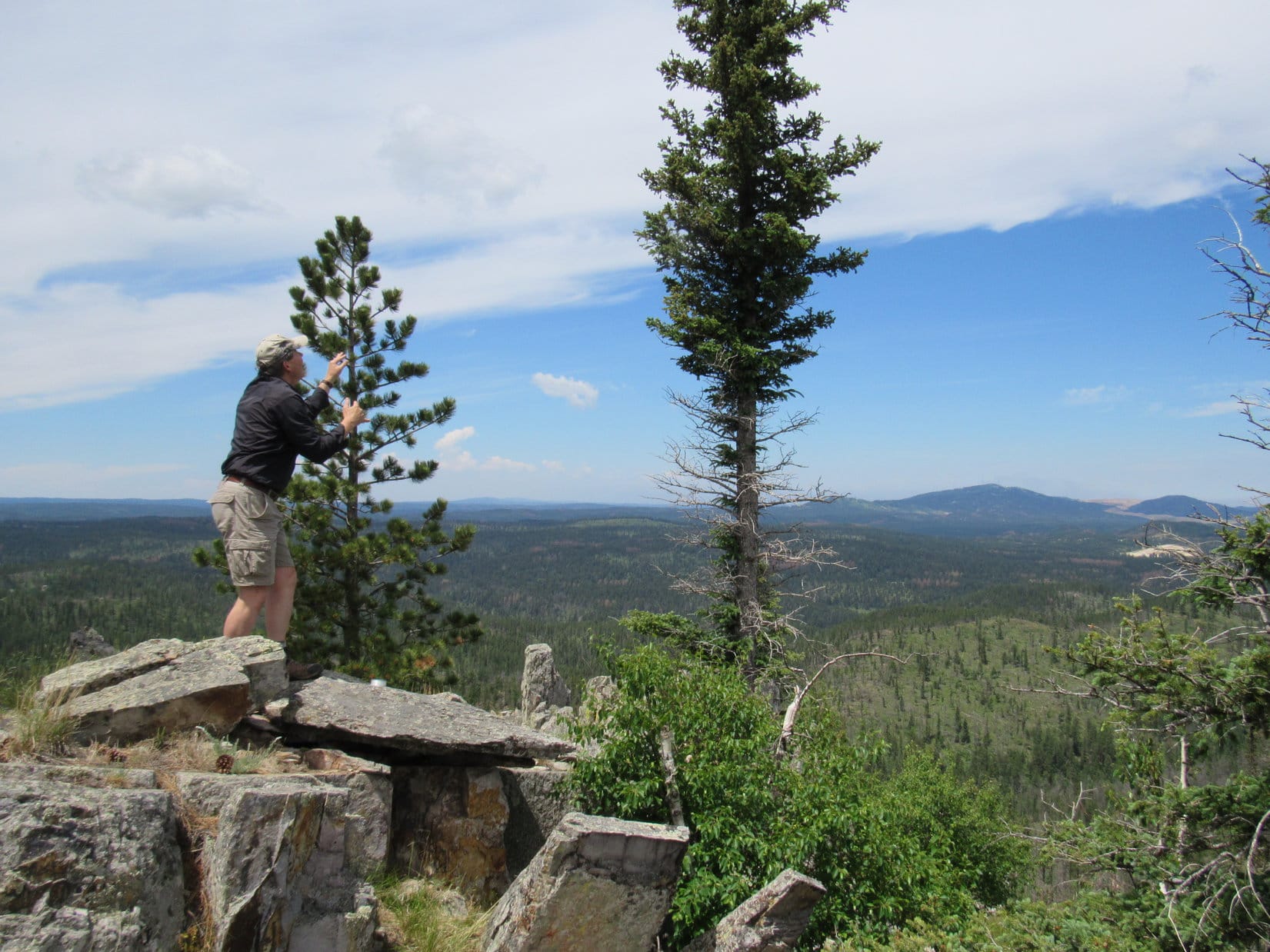
Preparations to start transmitting from Silver Mountain included setting up this 16 or 17′ long antenna with four lateral wires at the very summit. Photo looks NE.
Joe said he liked the layout on Silver Mountain(5,405 ft.). The forest had burned years ago, so there were no big trees around to obstruct the views in any direction. The mountain sloped away fairly steeply on most sides with nothing any higher for at least a couple of miles in any direction.
Although Silver Mountain was a good physical setup for Ham radio transmissions, Joe wasn’t at all certain how well things were going to work out. The 11 year sunspot cycle hits its low in just a couple more years, and atmospheric conditions are usually best for amateur radio band transmissions when sunspot activity is high, not low.
As it got close to 11 AM, everything was ready to go. The antenna and portable radio were all set up. SPHP was trained to keep a simple log of Joe’s contacts. Lupe and Dusty were prepared to ward off any intruders.
At 10:55 AM, Joe started transmitting in Morse code, receiving a first response almost instantly. That contact “spotted” AA0Q on SOTA’s website confirming contact with Joe. Silver Mountain was on the air!
An immediate explosion of activity came from dozens of “chasers” all trying to make contact at the same time. AA0Q was overwhelmed by the response, as usual. Joe did his best to make rapid contact with as many of the chasers as possible, but it was impossible to respond to more than a fraction.
AA0Q hard at it shortly after “activating” Silver Mountain. Photo looks SE.Dusty relaxes nearby while Joe works the Ham radio. Response from the chasers, as usual, was initially overwhelming.
Atmospheric conditions were changing rapidly. Joe and the chasers often exchanged signal strength information, which varied wildly over the span of only a few minutes. Of course, part of the variation was due to the different locations of the chasers. Successful contacts were made with operators in Arizona, California, Pennsylvania, the Carolinas and several other states.
With chasers lined up in droves trying to get through, each contact had to be brief.
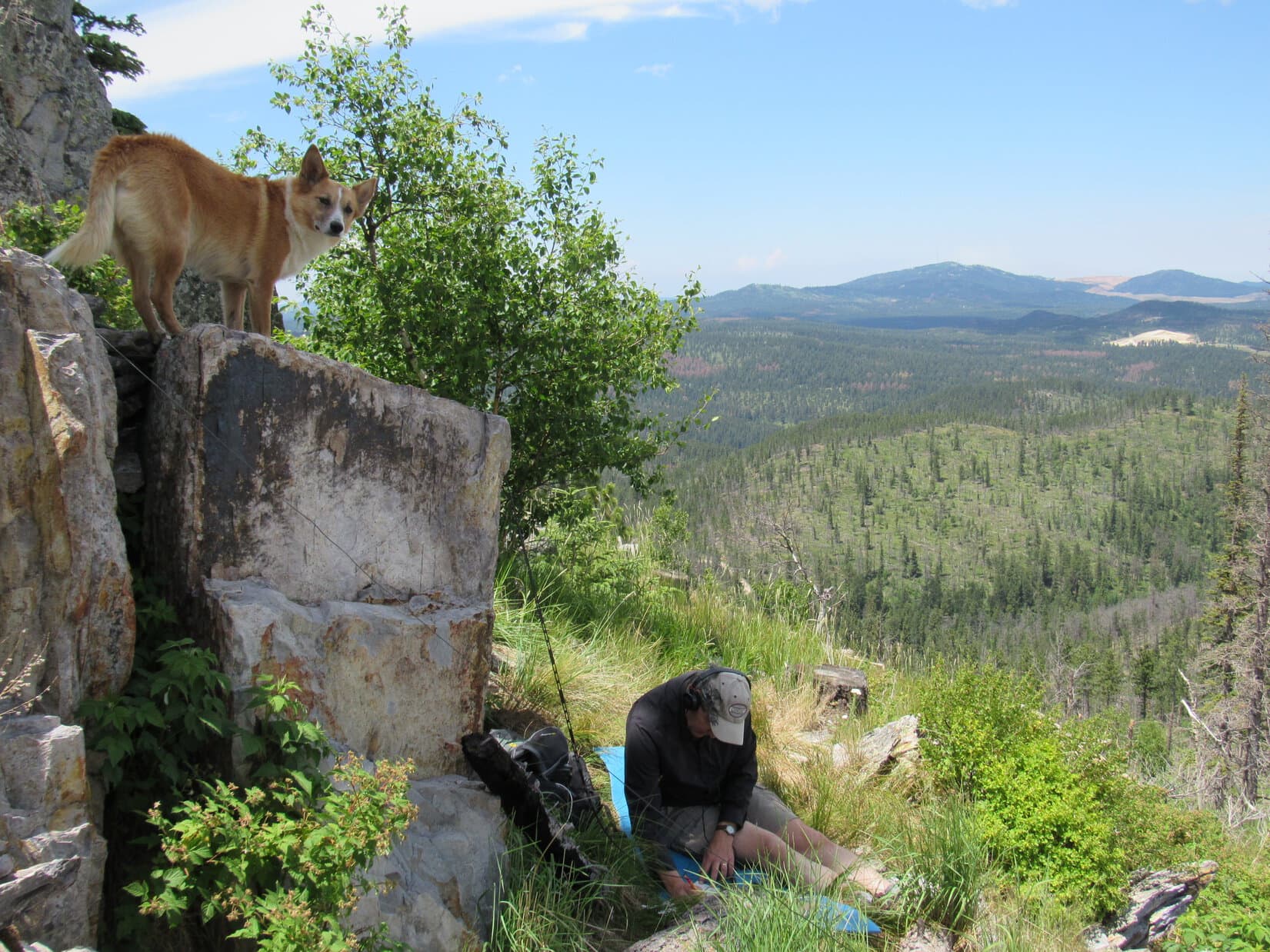
So, Uncle Joe, how is it going? Heard anything from anyone on Squirrel Mountain, yet? Lupe checks on AA0Q’s SOTA progress. Photo looks E.This photo shows the overall setup. The rocky summit ridge wasn’t the best for comfort, but AA0Q managed pretty well. Photo looks NNE.AA0Q’s portable radio in use on Silver Mountain.
For the first 10 or 15 minutes, conditions gradually improved. Signals were getting a little stronger on average, despite bouncing around. Later on, conditions deteriorated. At times the “bands” were down for a minute or two. AA0Q got a chance to shift to a more comfortable position.
As time went by, the bands went down intermittently, giving Joe a chance to shift to a more comfortable position. Photo looks SSW.
By 11:30 AM, 35 minutes after Joe started transmitting, it was over. The bands were consistently weak. The chasers had either made contact with AA0Q, or given up by now. Even when conditions improved momentarily, no one was left still trying to make contact. Evidently it was time to take down the antenna and put the radio away.
Joe at the top of Silver Mountain shortly before taking the antenna down. Photo looks NNE.Silver Mountain was the 3rd Black Hills peak AA0Q has activated. In July, 2016, Lupe and SPHP had accompanied Joe & Dusty to Custer Peak and Boulder Hill.
AA0Q had made 27 contacts in 35 minutes, so Joe was pleased with the overall results. Despite spotty atmospheric conditions, Silver Mountain had been a successful Summits on the Air outing. There always seem to be way more chasers than it’s possible to make contact with right after activating a peak, but Joe had done all he could.
Lupe got a pat from AA0Q for her guide services.
Lupe earns a pat from AA0Q for her Black Hills peak guide services. Photo looks NE.
Once the radio equipment was put away, it was time for a final look around at the views, followed by a short exploration of Silver Mountain’s summit area. Of course, the most impressive view was toward Black Elk Peak(7,231 ft.), the highest mountain in South Dakota.
Black Elk Peak(7,231 ft.) (R of Center) from Silver Mountain. Hwy 16 is seen below. Photo looks SW.
Silver Mountain’s summit area features two ridges running roughly N/S. The E ridge where Joe had set up the radio equipment is the highest. However, only a short distance to the W is an even rockier and more interesting ridge. The W ridge is only slightly lower than the E one.
The slightly lower, but more dramatic W ridge. Photo looks NW.
Between the two ridges, at the base of the E one, is one of many Dingo outposts Lupe has discovered scattered throughout the Black Hills.
Joe inspects Lupe’s Silver Mountain Dingo outpost. Joe was pretty certain it didn’t meet current building codes, but adventurous American Dingoes don’t give two hoots about that. Boulder Hill is in view beyond it. Photo looks NNE.
Joe was intrigued by the W ridge. He got up on top for a few minutes for a look around. Lupe and Dusty stayed below.
Joe got up on the W ridge for a look around. Slightly lower, Lupe is partially hidden among the small trees on the L, while Dusty sniffs around in the foreground. Photo looks W.
With Silver Mountain’s summit area explored, everyone headed back to the G6. There was still tons of time left in the day. Joe wanted to go climb Boulder Hill (5,331 ft.) again. Everyone piled into the G6. Joe drove 0.5 mile N to the start of the access road only 0.25 mile SW of the summit.
An easy trek along the access road led to a scenic path that winds up the large rock formation at the top of the mountain. Soon Lupe was at the summit with a great view looking back at Silver Mountain(5,405 ft.).
Silver Mountain (Center) from Boulder Hill. Photo looks SSW.
Joe has liked Boulder Hill ever since first climbing it with Lupe, Dusty and SPHP exactly one year ago on 4-22-16. In fact, he liked it so much that first time, everyone had come back to make a second ascent the very next day! On the 4th of July, Joe had even done a Summits on the Air activation of Boulder Hill.
Today’s Expedition No. 201 was Joe and Dusty’s 4th time up on Boulder Hill with Lupe and SPHP. Good times!
Joe on Boulder Hill near the area where he’d done a Summits on the Air activation of the peak on 7-4-16. Back then his antenna had been propped up in the big pine tree seen directly beyond him. Photo looks NW.Joe & Dusty together with Lupe on top of Boulder Hill for the 4th time. The first time up for Joe and Dusty had been exactly one year ago! Photo looks SE.
No Summits on the Air activation of Boulder Hill was planned for today. This was a pleasure excursion, just to see the views.
Silver Mountain (L). Photo looks SSW.Silver Mountain with a little help from the telephoto lens. The more dramatic, rocky W ridge is seen to the R of the true summit. Photo looks SSW.
After lingering at the top of the mountain for 15 minutes, everyone started back down. Time to head back to Lupe’s grandma’s house for food, fun and games. Lupe and Dusty looked forward to an afternoon of squeaker ball, tennis ball and flying disc action in grandma’s front yard. (End 2:00 PM, 62°F)
Joe (lower R) starts the trek down. Photo looks S.Lupe’s cousin Dusty on Boulder Hill. Photo looks E.
By the time Lupe and SPHP arrived at grandma’s house, Joe and Dusty were ready and waiting. Joe had already entered an alert on Summits on the Air! Joe, Dusty, Lupe and SPHP lost no time leaving for Boulder Hill(5,331 ft.).
Boulder Hill from USFS Road No. 358 (Boulder Hill Road) where Flume Trail No. 50 crosses the road. Photo looks S.
At 8:19 AM (71°F), Joe parked the G6 at the high point of the saddle on USFS Road No. 358 near the Boulder Hill access road. A cool N breeze could be heard in the pines. Lupe and Dusty were soon racing through the shady forest. Joe and SPHP took the access road.
Rain had finally arrived the day before – the real deal with thunder, lightning, small hail and at least an inch of moisture. Lupe found big tan mud puddles on the access road. She plunked herself down in several of them. She emerged with cool, tan mineral water streaming from her fur.
The access road was only 0.375 mile long. It ended at the base of the big rock outcropping at the top of Boulder Hill(5,331 ft.). A spur of Flume Trail No. 50 wound up among the rocks to a small, shallow saddle between the N and S high points at the summit of Boulder Hill. Good! No one was around. Joe would have his choice of sites to set up his ham radio equipment.
Two days earlier, Joe had had such a good time with his first Summits on the Air (SOTA) experience “activating” Custer Peak(6,804 ft.), that he wanted to try activating another peak in the Black Hills before he and Dusty had to head home to Arvada, Colorado. SOTA is “an award scheme for radio amateurs that encourages portable operation in mountainous areas”. Naturally, Lupe, Dusty, and SPHP had all wanted to come along again, too!
Joe decided to set up the radio equipment at the N end of the N high point. He taped a 12 foot fishing pole supporting an antenna wire as high up in a pine tree as he could. SPHP then helped Joe set up 4 lateral wires near the base of the antenna. Lupe and Dusty supervised, while guarding against intruders.
Joe and Dusty during setup of the portable ham radio. The 12′ fishing pole supporting the antenna can be see up in the tree toward the L. Several of the lateral wires can be seen, too.Lupe supervises while Joe finishes setting the radio up. Photo looks NW.
Pretty soon, the radio was ready. This time, Joe had a much better idea of what to expect once the radio was on. Before “activating” Boulder Hill, Joe gave SPHP the log book and a pen. SPHP received a 5 minute crash course on how to log the contact call signs, and other data Joe would call out while operating the radio.
AA0Q (Joe’s radio call sign) ready to get Boulder Hill on the air!
Set up had gone smoothly. AA0Q was ready to go on the air 5 minutes before the alert time Joe had posted on the SOTA website. As soon as Joe started transmitting, the same thing happened as at Custer Peak two days earlier. Within seconds of turning the radio on, a contact “spotted” AA0Q on Boulder Hill on the SOTA website. Moments later, Joe told SPHP that it was another “pileup”. Joe said it sounded like 30 hams were trying to contact him at once.
It was impossible to respond to them all, but Joe was better prepared than last time. SPHP logged the contacts, while AA0Q “worked” them using Morse Code. Joe recognized some of the contacts as repeats from his SOTA activation of Custer Peak. Others were new. The most distant contact was in Great Britain, which Joe said was very good for transmitting only 4 watts.
AA0Q on the air on Boulder Hill, with Dusty looking on. Photo looks NW.
Lupe and Dusty helped, too. At one point, three hikers arrived up on Boulder Hill while AA0Q was still transmitting. Both Lupe and Dusty barked a warning. SPHP stopped logging long enough to point out the lateral antenna wires, so they wouldn’t trip on them. SPHP also took a couple of group photos for the hikers using their camera.
Once again, Joe was rather amazed at the terrific response. His Summits on the Air activation of Boulder Hill was a big success. In roughly an hour, AA0Q worked 33 contacts by Morse Code, and one by voice. By activating Boulder Hill, AA0Q had earned 6 more points toward the SOTA “Mountain Goat” award. Including the 8 points earned on Custer Peak, he was now up to 14 points. SOTA was fun and added a whole new dimension to AA0Q’s amateur radio hobby!
When Joe was done transmitting, it was time to take down the antenna and pack up all the radio gear. When that was complete, Joe, Dusty, Lupe & SPHP went to explore a slightly lower high point a short distance to the N.
Joe and Dusty on the slightly lower high point to the N. Harney Peak (L of Center) is the highest point in the distance. Photo looks SW.Silver Mountain’s summit is in view just above Joe. Cliffs at the edge of the N summit area close to where AA0Q had been transmitting are seen on the L. Photo looks SSW.Joe stands near the spot where he had been transmitting from on the N summit. Photo looks S.
Of course, the peakbagger in Lupe wasn’t about to leave Boulder Hill without a visit to the S summit area, too!
Lupe on the S summit. Silver Mountain(5,405 ft.) is the grassy peak on the L. Harney Peak(7,242 ft.) is on the horizon on the R.AA0Q and Dusty at the S summit. Photo looks SW.Harney Peak using the telephoto lens. Photo looks SW.Part of Storm Hill (5,192 ft.) is seen on the L. Hwy 16 is visible on the R. Photo looks E.Joe and Dusty on the trail on the way down. Photo looks S.
By noon, Joe, Dusty, Lupe and SPHP were back at grandma’s house. Joe logged in all the QSO’s (contacts) he had made on the Summits on the Air website. All the contacts earned points toward the SOTA “Shack Sloth” award.
After lunch, Joe & SPHP went with other family members off into the hills again. SPHP wound up at Rushmore Cave, and Joe wound up at an antique shop in Keystone.
Lupe, Dusty and Maya (another dog in the family) were left behind with grandma. SPHP had given all three dogs water and a Beggin’ Strip before leaving. Grandma later reported that all the dogs spent the entire afternoon snoozing on the soft carpet in front of the fan. Being a “Radio-Active” Carolina Dog can be a tough life, but someone’s got to do it!
Summits on the Air map showing AA0Q’s activation of Boulder Hill.
Lupe returned from her grand adventures in the Laramie Mountains of Wyoming on June 1, 2016. Naturally, she expected to resume her explorations of the Black Hills in short order, but it didn’t happen.
May and June are normally the wettest months of the year in the Black Hills, but May had been very dry with temperatures running much above normal. By early June, the sun was blazing day after day in cloudless skies. Temperatures frequently soared to near record-breaking levels. Almost no rain fell. SPHP may as well have planted saguaros in the garden. For Lupe, climbing mountains in a fur coat would have been miserable. The Black Hills just aren’t high enough.
So Lupe’s adventures in June were mostly along the line of adventures in watering the lawn. She fought with the old garden hose, converting it into a sprinkler hose in the process. She chewed foot-long pieces off the end. She played tug-of-war with SPHP, won most of the time, and became a very soggy (and cool!) doggie in the process, as the leaky hose sprayed water in every direction.
When she wasn’t a soggy doggie, Lupe licked ice cream from the freezer and consumed cold Alpo from the refrigerator. A whole lot of panting and dozing went on the rest of the time. Whenever the temperature got close to 100°F, SPHP would finally break down and turn on the AC in the bedroom, so Lupe could hide from the heat.
Nothing really changed until July 1st. That morning, Lupe and SPHP woke up to rain! It wasn’t raining hard, but at least the air was much cooler and clouds covered the sky. Within a couple of hours, Lupe had another surprise. Andrea called! She was in town with Joe and Dusty! Did Lupe want to come over to grandma’s house and play?
When she heard the news, Lupe was ecstatic! She barked and leaped to hurry SPHP along. Soon she was racing up the steps into grandma’s house to welcome everyone to South Dakota in her most enthusiastic Carolina Dog style. Grandma had Beggin’ Strips for Lupe and Dusty. The two dogs got to play ball and Frisbee with Joe and SPHP in the yard, go for walks, and lay on the deck with a view of the canyon. There was ice cream, too. July was off to a good start!
Joe is a ham radio operator. He started telling SPHP about Summits on the Air, “an awards scheme for radio amateurs that encourages portable operation in mountainous areas”. Peaks are assigned a point value. Ham radio operators can earn points toward the SOTA “Mountain Goat” award by meeting certain criteria while operating from a peak, or points toward the “Shack Sloth” award for contacting those operating on a peak from home.
The home page for Summits on the Air (SOTA).
Joe had never tried the SOTA system before, but wondered if Lupe and SPHP would like to serve as guides to a suitable peak in the Black Hills? Since Summits on the Air combines Lupe’s peakbagging interests with Joe’s amateur radio hobby, it sounded like fun! Following the rain, the next day’s weather was supposed to be good, too, with highs only in the 70’s. The question was, where to go?
Joe and SPHP looked over the SOTA website. All of the Black Hills in South Dakota is included in two SOTA regions with a total of 181 listed peaks. Most of these peaks have never been officially “activated” in the Summits on the Air system by anyone operating a portable radio from the peak. After considerable discussion, Joe and SPHP selected Custer Peak(6,804 ft.) for Joe’s first SOTA attempt. Joe created a free Summits on the Air account for himself.
The next morning, Joe posted a notification (called an “alert”) on the SOTA website that Joe (call sign AA0Q) would be operating his portable radio from Custer Peak. The alert included the frequencies he would be using, and an estimated start time. Once the alert was posted, Lupe, Dusty, Joe and SPHP dashed off to Custer Peak!
At 10:58 AM (72°F), Joe parked the G6 at Lupe’s usual starting point at the junction of USFS Road No. 216 (Custer Peak Road) and USFS Road No. 216.2A. Although Lupe was only a little over 0.5 mile SE of the summit, the road to Custer Peak was nearly 2 miles long. Lupe, Dusty, Joe and SPHP started the trek to the top along No. 216.2A.
Looking S from No. 216.2A near the start of the trek up Custer Peak (not shown).
Although Joe and Dusty had never been to Custer Peak before, this was Lupe’s 6th ascent. Based on prior experience, SPHP had been telling Joe not to expect to see anyone at all on Custer Peak. SPHP couldn’t have been more wrong! SPHP’s pronouncement quickly became a joke. First, Lupe and Dusty started coming to vehicles parked along the road. Then dozens of people began to appear, most of them arriving in caravans of 4 or 5 ATV’s.
ATV’s roared up and down the dusty road. As Lupe, Dusty, Joe and SPHP got higher on the mountain, Lupe also encountered groups of people coming down on foot. SPHP was totally amazed! What SPHP had failed to consider was that Lupe normally goes on very few expeditions in the Black Hills during the hot summer months, when everyone else is out and about. Apparently, Custer Peak is a far more popular summer destination than SPHP ever realized.
Another surprise was in store at the top of the mountain. The ranger station was manned! The hatch door to the balcony around the station was unlocked and open. Lupe, Dusty, Joe and SPHP went up on the balcony for a look around.
Lupe and Dusty on the ranger station’s balcony. Although this was Lupe’s 6th ascent of Custer Peak, she’d never been up on the balcony before.
Joe found the ranger on duty to tell him that he would be operating a portable ham radio using 4 watts from the summit for an hour or so. He just wanted to make certain it wouldn’t interfere with the ranger’s equipment.
The ranger didn’t think there was any equipment the radio would interfere with. However, that didn’t mean there wasn’t a problem. The American people declared independence and proclaimed freedom nearly 240 years ago, but times have changed. The Land of the Free and Home of the Brave is now the Land of the Over-Regulated and Home of the Bureaucracy. The ranger was cordial, but insisted that Joe contact the headquarters of the Spearfish district of the Black Hills National Forest to get official permission to operate the ham radio.
Neither Joe nor SPHP had a phone along, but the ranger allowed Joe to use his phone. Naturally, since it was Saturday on the 4th of July holiday weekend, all Joe got was a recording. The headquarters of the Spearfish district of the Black Hills National Forest wouldn’t be open until Tuesday. Joe reasoned with the ranger inside the station. Meanwhile, SPHP stayed out of it with Lupe and Dusty on the balcony.
It turned out the ranger’s concerns had to do with the ranger station being part of a designated historical site of some sort. The ranger thought operating a ham radio might somehow break the historical site regulations. Fortunately, the ranger had a map of the historical site area. It covered only a relatively small part of the summit area surrounding the ranger station.
Joe and the ranger finally agreed that the NE side of a jagged rock outcropping a little way NW of the ranger station was outside the boundary of the historical site delineated on the map. The ranger was OK with Joe setting up the ham radio operation over there. That was a relief! Lupe, Dusty, Joe and SPHP left the ranger station to go set up the antenna and other equipment.
Joe made a perfect toss of a large metal nut tied to fishing line up over the very top of a tall tree situated near the spine of the jagged rock outcropping. The fishing line was then used to pull up a thin antenna wire. Joe instructed SPHP on how to help deploy 4 lateral wires at the base of the antenna.
The ground on the NE side of the ridge was quite steep and rocky, so it took a little time to maneuver around and get set up. Lupe and Dusty supervised operations from the most comfortable vantage points they could find.
Joe makes a perfect toss of a metal nut tied to fishing line over the top of the tall thin tree near the ridgeline. The fishing line was then tied to a very thin antenna wire, and pulled up to the top of the tree. Photo looks NW.Lupe supervises from the shade while Joe sets up his portable ham radio NE of a jagged rock outcropping NW of the ranger station.Joe and Lupe continue working on the portable ham radio setup. Dusty sneaks off to check out SPHP’s backpack on the chance there might be something good in it. One of the lateral wires can be seen in front of Dusty. Photo looks S.Joe nearing completion of the portable ham radio setup. Joe’s call sign is AA0Q.Dusty finds a shady spot to rest near some of the lateral wires. Photo looks E.
The ranger’s concerns, and the rough ground where Joe was forced to set up the radio, slowed things down. By the time Joe was ready to try his very first Summits on the Air peak activation, it was more than half an hour after the time Joe had posted on the SOTA website. Would any other ham radio operators still be listening for AA0Q on Custer Peak? Joe had no idea what to expect.
Joe turned on his radio. AA0Q was on the air on Custer Peak! Almost immediately, another ham radio operator made contact with Joe. (A contact is apparently referred to as a QSO.) The contact told Joe that he would “Spot” him on the SOTA website. Although Joe has many years of experience with ham radio, he wasn’t prepared for what happened next.
Almost instantly, there was a “pileup”. Joe shouted out to SPHP that it sounded like 20 people were trying to contact him all at once!
While Lupe looks on, Joe is instantly swamped by the response to his Summits on the Air activation of Custer Peak! Terry Peak(7,064 ft.) (R of Center) is the highest mountain in the distance. Photo looks NW.Dusty, surrounded by wires, looks happy with all the success Joe is having with his very first ever activation of a peak using Summits on the Air.AA0Q’s portable ham radio during use on Custer Peak.
Joe had a frantic time trying to respond to the enormous demand. Mostly he was quiet, busy listening intently through the headphones while using Morse Code to reply to as many of the radio operators seeking him as possible. At the same time, he was trying to log the call signs, time of contact, location and a few other details of each successful contact. Just to keep Lupe, Dusty and SPHP informed, now and then he called out where the operators he was “working” were from.
The pileup eventually ended as those trying to contact Joe either got through, or gave up on reaching him. After half an hour, new contacts were sporadic. Joe kept his radio active another 15 minutes, switching to a voice frequency toward the end. After one or two voice contacts, Joe was satisfied. He’d managed to make and log 15 different QSO’s (contacts) from ham radio operators scattered all over the USA.
Joe was pretty happy with his first SOTA experience. AA0Q had never been so popular and in demand before! He’d made mistakes that kept him from “working” many of those who had tried to contact him, but Joe had learned a lot. In the future, it would be easy to correct the worst errors. Keeping the contacts short was vitally important. People wanted their “Shack Sloth” points awarded for a successful QSO fast! No dilly-dallying around allowed in this business. Next time, Joe would have SPHP do the logging.
After taking down the antenna and putting the radio equipment away, it was time to return to the summit for a few pictures. Joe also wanted to chat with the ranger to let him know his SOTA radio operation was over.
Up on the jagged ridge before returning to the summit. Photo looks SE from a point not too far from Joe’s SOTA activation of Custer Peak.Joe, Dusty & Lupe below the ranger station. Photo looks SE.At the summit.AA0Q was the first to ever use Lupe’s “Radio-Active” American Dingo guide services in the Black Hills for a Summits on the Air peak activation. AA0Q earned 8 points toward SOTA’s Mountain Goat designation for “activating” Custer Peak(6,804 ft.)! Photo looks NW toward Terry Peak.Looking NE.Looking SSW.
Joe’s operating point on the NE side of the jagged NW ridge hadn’t been the easiest place to work from (or the most comfortable), but it did have a couple things going for it. The NE side of the ridge was hidden from the trail to the ranger station, so Joe hadn’t been bothered by all the people coming and going. The site had also been close enough to the top of the mountain to meet SOTA’s standards for a “peak activation”.
Joe and Dusty start down the trail. Joe had conducted his SOTA activation of Custer Peak from the opposite side of the jagged NW ridge seen here. Photo looks N.Lupe on the jagged NW ridge. Photo looks N.
When Joe, Dusty, Lupe and SPHP got back to grandma’s house, Joe logged all 15 contacts (QSO’s) he’d made into the Summits on the Air website. Joe was awarded his first 8 of 1,000 points required to earn the “Mountain Goat” designation. The 15 QSO’s each earned points toward the 1,000 points required for the “Shack Sloth” designation.
The SOTA map showing the activation of Custer Peak by AA0Q earlier in the day.
Joe was happy. Lupe and Dusty were happy, too. They had earned extra ice cream and Beggin’ Strips for becoming “Radio-Active”!


 With Silver Mountain’s summit area explored, everyone headed back to the G6. There was still tons of time left in the day. Joe wanted to go climb Boulder Hill (5,331 ft.) again. Everyone piled into the G6. Joe drove 0.5 mile N to the start of the access road only 0.25 mile SW of the summit.


 No Summits on the Air activation of Boulder Hill was planned for today. This was a pleasure excursion, just to see the views.