Start: 12:24 PM, 58°F at the intersection of Song Dog Road & USFS Road No. 373
Lupe hopped out of the G6. 20 expeditions and almost 8 months ago, she had come here to climb the Twin Sisters Range High Point(4,980 ft.). She’d made it to the top easily enough, but when she’d gone farther E to explore more of the area, the buzz of an unseen rattlesnake had put a quick end to that notion.
Even though it was an incredibly warm day for December, rattlesnakes weren’t likely to be stirring now. Lupe should be able to do all the exploring she wanted to today. The Carolina Dog started out heading E on USFS Road No. 373.
Lupe on USFS Road No. 373 approaching the W end of the Twin Sisters Range. Photo looks E.
A mile from the G6, Lupe left the road and started the short, but steep climb up a SW slope to the W end of the Twin Sisters Range. Despite a few brief stops for SPHP to catch breath, Looper was soon at the top.
Lupe begins her trek up the short, but steep SW slope. Photo looks NE.Lupe arrives up on top at the far W end of the Twin Sisters Range. Photo looks WNW.
A dangerous, rusty barbed wire fence was laying on the ground. SPHP made certain Lupe didn’t get into it. A 20 mph wind blew out of the NW. Normally, it would have been frigid here in December with a wind like that. Today, though, it was so warm out the wind was only a nuisance.
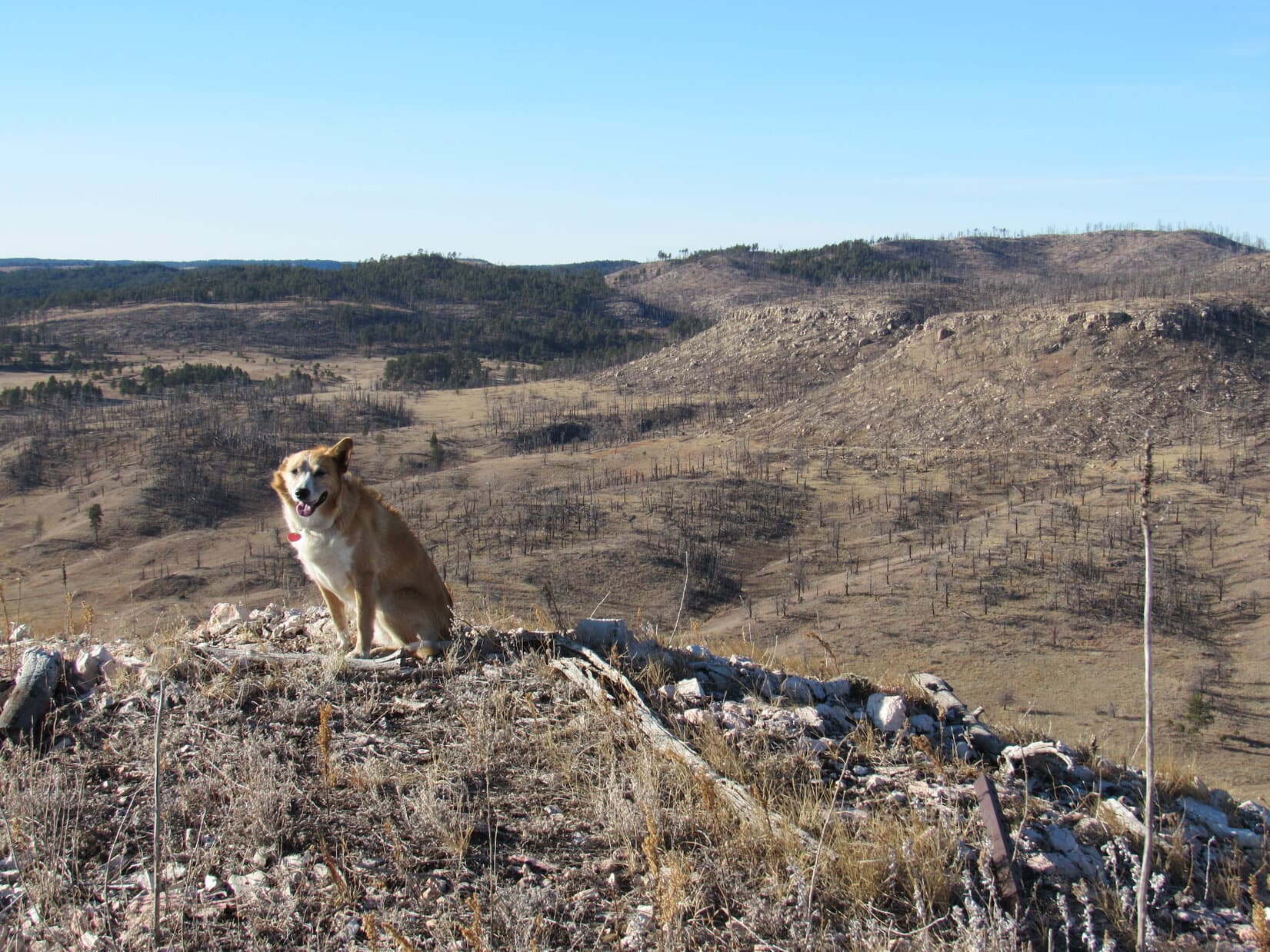
Much of this area had burned in a forest fire years ago. As a result, Lupe had sweeping views of barren, forlorn vistas. Dull, dry, dead grass covering the land did little to add any cheer.
The sweeping views Lupe had looked barren and forlorn. High Point 5017 is seen on the L. Photo looks WSW.
The actual high point of the Twin Sisters Range was still another 0.25 mile E. After enjoying the views from the W end of the ridge, Lupe and SPHP set off for the cairn at the summit.
The summit of the Twin Sisters Range (R) was still another 0.25 mile to the E. Photo looks ENE.Looper starts for the summit (L). Photo looks E.
The stroll to the summit was easy. Lupe had great views the whole time from the open ridge. It wasn’t long before Loop was at the summit cairn. Of course, the NW wind was blowing here, too. Not enjoying the wind, Lupe stayed only long enough at the summit for photos by the cairn, and a fairly quick look at the sights.
Looper by the cairn at the top of the Twin Sisters Range High Point(4,980 ft.). It hadn’t taken her long to get here, but the NW wind was as bad as ever. Photo looks E.Looking SE from the summit cairn. Buffalo Gap is seen in the distance on the L. Elk Knob is the partially forested low hill seen straight up from Lupe’s head (R).Looking W back along the ridge Lupe had just traveled across.High Point 5017 is on the far L. Photo looks WSW.Looking SE farther along the the Twin Sisters Range. Buffalo Gap (Center) is near the horizon. Elk Knob is the low mostly forested hill on the far R.The pine-dotted hill on the R is at the lower E end of the Twin Sisters Range. Photo looks E with help from the telephoto lens.
Loop and SPHP left the Twin Sisters Range High Point continuing E down to a lower part of the ridge. Loop regained some lost elevation climbing up to High Point 4872. High Point 4872 was windy, too, but Lupe paused briefly for a few photos.
Looking back at the Twin Sisters Range High Point (seen straight up from Loop) from High Point 4872. Photo looks NW.Elk Knob(4,752 ft.) (R) from High Point 4872. Lupe would be going to Elk Knob next. Photo looks SE.High Point 4820 is on the L. Buffalo Gap is R of Center. Looking SE from HP 4872.
At High Point 4872, Lupe was already well beyond where she’d been back in April on Expedition No. 199. The topo map showed another lower hill a mile off to the SE known as Elk Knob(4,752 ft.).
Elk Knob became Lupe’s next objective. She started down High Point 4872’s S slope, and was quite happy when she finally reached a valley where the wind was barely stirring.
On the way down High Point 4872’s S slope. The Twin Sisters Range High Point is in view on the R. Photo looks NW.
The trip up Elk Knob was easy. Lupe first went to a saddle N of the hill, then followed the N slope up. The hill was heavily forested, until she got near the top. Lupe liked being in the forest on Elk Knob a lot better than on the bare, windy Twin Sisters Range ridge. She had a good time racing around sniffing and exploring.
The summit of Elk Knob proved to be a big, flat grassy area rimmed with pines. The pines were dense toward the N, but more sparse elsewhere. For a fairly low hill in this area, Elk Knob had some pretty good views. The wind wasn’t too bad, either, except near the more exposed W end.
Lupe on the big, flat grassy summit of Elk Knob. Photo looks S.The view to the S was surprisingly open and nice. Lupe could see quite a long way from here. Photo looks S with help from the telephoto lens.Happy Lupe on Elk Knob.Here Lupe is down a little off the summit on Elk Knob’s upper W slope. It was windier here than elsewhere, but she could see the Twin Sisters Range High Point (on the R straight above her head), and much of the territory she’d just traveled through. Photo looks NW.View to the NNE from Elk Knob.
Lupe took a break on Elk Knob. The usual water and Taste of the Wild, with an apple for SPHP. Then it was time for more exploring. Loop went NE down off Elk Knob, before turning E and SE. She wandered along several dirt roads. Only one had a sign, which said she was on USFS Road No. 373.1D.
The Carolina Dog ventured down into a fairly deep canyon. She followed a faint remnant of a road at the bottom, but it eventually ended. Loop climbed up the NE side of the canyon, and reached a ridge she took SE. The sun was getting low by the time she reached a big fence. This had to be the fence along the W side of Wind Cave National Park.
Lupe explored territory E of Elk Knob until she got to this big fence somewhere along the W boundary of Wind Cave National Park. Photo looks SE.
The fence was as far E as Lupe could go. It was getting late enough so she needed to start back anyway. On her return trip she avoided the canyon by staying farther N. She eventually passed back over the saddle N of Elk Knob heading NW.
The sun wasn’t quite down yet as Lupe neared the Twin Sisters Range again. Why not return to the summit? Well, there was the wind, for one thing. It wasn’t bad at all down here, but was still blowing up there. However, seeing the sunset from a mountaintop seemed more important. Up Lupe went.
Climbing the Twin Sisters Range again, this time from the S. Photo looks NW.Nearing the Twin Sisters Range High Point (L) for a second time today. Photo looks N.
The last bit of the sun was disappearing behind High Point 5017 when Lupe reached the Twin Sisters Range High Point(4,980 ft.) again. The sky was almost completely clear, with only a few small clouds to the W. With so few clouds, the sunset never really got a chance to develop into anything special.
Lupe reaches the Twin Sisters Range High Point for the 2nd time today, just as the last bit of the sun slips below HP 5017. Photo looks W.
For a little while, Lupe and SPHP sat together in the wind on the barren, forlorn mountaintop, watching the light fade until hopes for a colorful sky died old and gray. Time to go.
Being on the move again felt good. It was fun picking a way down the steep rocky slope, and marching across a field back to the road. Next came a mile of shared silence and solitude beneath a darkening sky. At the G6, a few stars glittered above. Water, a little more Taste of the Wild, and Lupe was homeward bound. (5:03 PM, 46°F)
On the Twin Sisters Range High Point right after sunset, 12-10-17
Want more Lupe adventures? Check out her Black Hills, SD & WY Expeditions Adventure Index, Master Adventure Index, or subscribe free to new Lupe adventures!
Start (10:25 AM, 54°F), intersection of Dog Song Road & USFS Road No. 373, 4 miles SE of Pringle.
Cool rainy weather, even a skiff of snow, had delayed Expedition No. 199 for several days, but Lupe was finally on her way! Although she had finished up the last of the Brian Kalet peaks she was going to climb in the southern Black Hills on Expedition No. 198, she was still headed S, just not quite as far S as before.
Lupe’s first peakbagging objective for the day was the high point of the Twin Sisters Range(4,980 ft.). The Twin Sisters Range is really no more than a 2 mile long ridge running E/W within the Black Hills. For some reason this ridge, which isn’t particularly high even compared to nearby terrain, has its own name on the maps while countless similar ridges do not.
No matter, if the Twin Sisters Range was on the maps, that was good enough for Lupe! After she reached the high point, the plan was to explore much of the rest of the ridge. Maybe Lupe would even go on to Elk Knob, another minor high point 0.5 mile farther S?
Approaching the area from the W, it became clear Lupe would not only have an easy time up on the ridge, she would have some great views, too. The Twin Sisters Range looked barren and exposed.
The W end of the Twin Sisters Range looked barren and exposed. Lupe was going to have some great views up there! Photo looks E from Dog Song Road.At the starting point. The G6 is parked just off Dog Song Road (not pictured). Lupe would follow USFS Road No. 373 to get to the W end of the Twin Sisters Range, about a mile E of here. High Point 5017 is the ridge seen in the background. Photo looks SE.
From the G6, Lupe followed USFS Road No. 373 going E toward the W end of the Twin Sisters Range. This was a super easy, level stroll in upper Cold Spring Creek valley. The creek must have been underground here. It was nowhere in sight. A steady E breeze made the day seem cooler than it really was, but meadowlarks were singing cheerfully. Lupe was cheerful, too! She liked this place.
Shortly after setting out, Loop reached a locked gate across No. 373 at the W end of an area serving as the water supply source for Wind Cave National Park. The 0.5 mile long area is not connected to the rest of the park, located 2 miles farther E. No vehicles could go beyond the locked gate, but Lupe could. It didn’t take her long to reach the far E end where she found no gate, only a cattle guard.
After passing through the park water supply area, No. 373 angled SE and entered a thinly forested area. Lupe began to gain elevation. The W end of the Twin Sisters Range was now close at hand.
Getting close to the W end of the Twin Sisters Range. Photo looks E from USFS Road No. 373.
Lupe followed No. 373 gradually uphill until she was SW of the W end of the Twin Sisters Range. Here, SPHP led her off the road to begin the real climb.
Lupe and SPHP left the road to begin the climb up to the W end of the ridgeline here. Photo looks NE.
After all the cactus she had been having to dodge for the last couple of months while climbing Brian Kalet peaks farther S, Loop wasn’t at all certain leaving the road was a good idea. In fact, she was pretty positive it wasn’t. This barren ridge looked a lot like some of those cactus-infested areas. She begged SPHP to carry her.
The Twin Sisters Range was a few hundred feet higher than most of the peaks Lupe had been climbing lately. It was definitely sunny and exposed, which is good for cactus, but SPHP hadn’t seen any yet. Maybe this area was high enough to be above cactus line? Cactus usually disappears somewhere in the 4,700 to 5,000 foot range in the Black Hills.
SPHP didn’t carry Lupe, only encouraged her to keep climbing. She followed somewhat reluctantly. However, her confidence grew as she made rapid progress up the slope without encountering any cacti.
Shortly before reaching the ridgeline, there was movement on the ground. Lupe saw a snake! It was gray-green and smallish, but coiled up and surprisingly active. SPHP didn’t know what kind of snake it was, but it was clearly harmless.
Lupe came across this snake as she neared the top of the ridgeline. It was harmless, but surprisingly active on this cool, breezy day.
Even though the snake was harmless, SPHP was a little concerned about seeing it. The snake seemed plenty lively despite the cool, breezy day. Snakes are quite rare in most of the Black Hills, but are much more common at lower elevations. In all her expeditions and adventures in the Black Hills, Lupe has never seen a rattlesnake.
One of the reasons Lupe had been climbing the lower Brian Kalet peaks of the southern hills early in the year when it was cold out was to avoid encountering rattlesnakes. Due Lupe’s small size, a rattlesnake would be much more of a danger to her than to SPHP, and she might not know to stay away if she came to one.
Lupe might be above cactus line here, but seeing the harmless snake proved she wasn’t above snake line yet. SPHP couldn’t ever remember seeing a rattlesnake above 5,500 feet in the Black Hills, but that was more than 500 feet higher than the Twin Sisters Range. Seeing the harmless snake also proved spring had progressed far enough along so snakes were now active.
Dry, sunny, and topped by a layer of weathered limestone undoubtedly offering plenty of little caves and crevasses to hide in, the Twin Sisters Range did look like prime rattlesnake country. Still, seeing a single harmless snake didn’t mean the area was infested. SPHP encouraged Lupe to stay close from now on, though, as she finished her climb.
It only took Lupe a couple more minutes to reach the top at the W end of the ridge. The views were excellent!
Lupe reaches the W end of the Twin Sisters Range ridge. The views were excellent! Without any trees around, Loop could see in every direction. Photo looks W at the Cold Springs Creek valley she had traveled through to get here.The high point of the Twin Sisters Range (R) from near the W end of the ridge. Photo looks ENE.
The Twin Sisters Range High Point(4,980 ft.) was less than 0.25 mile away. An easy stroll E along the ridge, and Lupe was claiming her first peakbagging success of the day! That was easy!
Lupe reaches the summit cairn at the Twin Sisters Range High Point. Photo looks W.At the summit cairn. Photo looks E.The lower end of the Cold Spring Creek valley. Photo looks ENE.
With the 360° view available from the Twin Sisters Range High Point, Lupe could see many mountain peaks she had visited in the past, including a lot of the ones she had been to in the last couple of months in the southern Black Hills. Most of them were many miles away.
Looking N toward Northeast Cicero Peak(6,240 ft.)(Center). Mount Coolidge(6,023 ft.)(far R) is also in view.High Point 5017 is the large, barren ridge in the foreground. On the far horizon are Parker Peak(4,848 ft.)(L) and Matias Peak(4,780 ft.)(Center). Photo looks SW.Much of the territory around (and including) the Twin Sisters Range had burned years ago. This photo looks NW at some of the devastation.
From the summit, Lupe could see the rest of the Twin Sisters Range ridgeline to the E. She would get to explore much of this territory on her way to Elk Knob. It looked like fun! The Carolina Dog would enjoy great views all the way.
Looking SE at the rest of the Twin Sisters Range ridgeline. Lupe would have a great time exploring it on her way to Elk Knob! Buffalo Gap is in view in the distance at the edge of the hills a little R of Center. Peak4160 is the long ridge to the L of it at Center. Unkpapa Peak(4,280 ft.) is the long ridge to the R. Lupe had been to both only 10 days ago on Expedition No. 198.
After enjoying the views from the breezy summit, Lupe headed SE down the ridge starting her trek to Elk Knob. For 5 minutes, it was fun being able to see so much. In an instant, everything changed.
Looper, you OK?!
Yes, of course! You were right, no cactus up here. Makes life a lot more pleasant! This is way better than some of those other mountains.
Yeah, but we’re not staying. Time to go! There’s worse things than cactus. Hear that buzzing?
With these big soft Dingo ears, how could I not hear it?
Well, remember that sound. That’s a rattlesnake. Poisonous, perhaps deadly to Dingoes if one bites you! We must have passed within a few feet of it seconds ago. It’s right over there somewhere. Stay here! Don’t go over there.
Yikes! Are you serious?
Very. Two snakes in what, maybe 20 minutes, up here? One of them poisonous. It changes everything. We aren’t going to spend hours strolling around on Rattler Ridge courting disaster. Forget that. If you like this place, we can come back another time, like on a warmish day in December or January. Won’t be any snakes then.
Yeah, suddenly I’m thinking this place would look gorgeous with a couple inches of snow on the ground!
Yup, exactly, let’s skedaddle, but stay close till we’re down off this ridge.
The buzzing had lasted maybe 20 seconds before it stopped. SPHP pitched 8 or 10 rocks back toward the source, but the buzzing didn’t start up again. SPHP walked a little closer, but saw nothing. Maybe the snake had slithered into some hole? Didn’t matter, there wasn’t any doubt. A rattler had been there. Elk Knob wasn’t happening. Not today. No way!
Looking NW back up at the Twin Sisters Range High Point. This was as far as Lupe got on her way to Elk Knob due to the rattlesnake she’d heard only a few minutes ago.
Lupe didn’t go back up to the Twin Sisters Range summit. She took a shortcut going SW down off the ridge. This route was more direct and less steep than the way she’d come up. She came to no more snakes.
The return trip to USFS Road No. 373 was uneventful. SPHP did see the one and only cactus patch of the day, but it was easily avoided. The most exciting thing Lupe encountered along the way was some sort of huge ant festival going on at a rotting log.
Lupe starts down the S side of the ridge. If you want a good idea of what prime rattlesnake territory looks like, this is it. Photo looks W.Lupe saw no more snakes. The most exciting thing she saw coming down off the ridge was this big ant festival being held at a rotten log.
All’s well that ends well. Loopster reached USFS Road No. 373. At least she had made it to the top of the Twin Sister’s Range High Point! Elk Knob could wait.
On the way back to the G6 along USFS Road No. 373. Photo looks WNW.
The stroll back to the G6 along the road was nice and relaxing. The whole journey to the Twin Sisters Range High Point hadn’t taken long, only a little over an hour and a half (12:07 PM, 54°F). There was oodles of time left in the day.
That was OK! SPHP had a backup plan. There was another Twin Sisters on the maps Lupe could visit.
On the way back to Hwy 89 on Dog Song Road, SPHP stopped the G6 for this look back at the Twin Sisters Range High Point (L). Goodbye Rattler Ridge! Photo looks E.
Well, Loopster, that was it! We are done with this low country stuff now until it gets cold again in the fall. No more cactus. No more snakes. We are staying high. If we manage not to fall off of anything and can avoid the barbed wire, we should be golden. Of course, there’s always mountain lions, and hunters, but oh well, never mind. We’ll be fine.
That sounds, great! I can’t tell you how sick I was getting of cactus.
No doubt, but you were getting better at handling it, too. We had fun! Saw some great stuff.
Maybe, not nearly enough squirrels, though. So where we going now?
Twin Sisters again. Another Twin Sisters(5,920 ft.), a different one. These next Twin Sistersare W of Custer. They are nearly 1,000 feet higher than the ones we just left. Should be plenty of trees, no cactus, no snakes, and maybe you will see some squirrels.
I hope you’re right. Strange that both places have the same name.
Yeah, actually, there is a third set of Twin Sisters(5,244 ft.) in the Black Hills, too. It’s even farther N, between Pactola and Sheridan Lakes, practically right off the Centennial Trail. You’ve already been there, but it was a long time ago. You weren’t even 14 months old yet. So after this next set, you will have visited 3 different Twin Sisters in the Black Hills.
Like a whole litter of sisters!
You could say that.
When Lupe jumped out of the G6 again at Comanche Park campground off Hwy 16, she knew instantly this place was more to her liking (12:59 PM, 52°F). She sniffed the air briefly, then took off running in circles. It was true! No more cactus! One of the first trees she checked even had a squirrel in it! Things were definitely looking up.
The new Twin Sisters were less than 2 miles away. Lupe and SPHP headed S through Comanche Park campground. A little beyond it, a few houses were around, part of some subdivision, but the private property wasn’t hard to avoid. Most of the area was national forest land.
The terrain Lupe traveled through was rolling and forested. Much of the forest had been thinned, so it was quite open and easy to see what was ahead. Before long, the N Twin Sister(5,920 ft.) was in view. It was the highest of the two.
The N Twin Sister comes into view S of Comanche Park campground. Photo looks S.
Lupe headed straight for the mountain. As she got closer, it looked like it might be best to start up along the NW ridge. The climb wasn’t difficult, although it became steeper as Lupe got higher up.
When she was already fairly high, Lupe reached a prominent point capped by some unusual looking rocks. The rocks formed a couple of platforms, one large and one small. Lupe got up on both to look around. From the smaller platform, she had a decent view to the NNE.
Lupe on the small platform of cool rocks on her way up the N Twin Sister. She was already high enough to have a pretty decent view from here. Photo looks NNE.A happy finally-out-of-cactus-country American Dingo on the smaller platform. Sylvan Hill(7,000 ft.) is the distant ridge on the R. Photo looks NNE.
Trees blocked the views from the larger platform. Still, it was fun climbing around on the interesting rocks.
Lupe below the highest rocks of the larger platform.
Lupe finished her climb following the N ridge. The route was modestly steep, but not difficult. Soon Looper was standing on a stump at the very top of the N Twin Sister. Since this was the highest sister, she’d already accomplished her peakbagging goal here. Easy, squeezy!
Ta da! Lupe stands on a stump at the summit of the N Twin Sister. Since this was the highest one, she was able to claim another Dingo peakbagging success! The S Twin Sister is in view beyond her. Photo looks S.
The summit area was plenty roomy. Three prongs radiated out from the central high point. One off to the N, one to the E. The third and longest prong sloped down to the SW. The views were best from the two shorter prongs, due to breaks in the forest.
Looking NNW from the N prong.Lupe at the edge of the E prong. Northeast Cicero Peak(6,240 ft.) (Center) is the high point on the horizon. Photo looks ESE.The summit area on the N Twin Sister was plenty roomy. This photo looks W from the E prong, and shows more than half of the summit area.
Lupe and SPHP took a break near the summit. Lupe had her Taste of the Wild and water. SPHP consumed an apple.
A number of birds were flying around. The Bluebird of Happiness showed up and hung around for quite a while. Lupe was glad to see him! She was certain now that her past few months of cactus ordeals were over. The Bluebird of Happiness would never steer you wrong, would he?
The Bluebird of Happiness paid Lupe a visit up on the N Twin Sister. It had been a year since she’d last seen him up on Twin Buttes(4,949 ft.) during Expedition No. 166. Maybe the Bluebird of Happiness had a thing for twins?
After the break, Lupe went down into the saddle leading to the S Twin Sister. It was an easy jaunt down a modestly steep slope. The climb up the S Twin Sister was steeper, but not bad. A lot more rocks were over here. Lupe went up along the NW side since there were cliffs on the N and NE sides.
Lupe got up on the cliffs for a look back at the N Twin Sister.
On top of the cliffs along the NE edge of the S Twin Sister. The N Twin Sister where she had just been is in view. Photo looks N.
The S Twin Sister had a much larger summit area than the N Twin Sister. There were two high points, one to the N and one to the S. The N one seemed to be a little higher than the S one, but Lupe found great viewpoints from both. Trees always blocked the views to the NW, but it was possible to see in any other direction from some part of the mountain.
Lupe took a tour of the entire summit area. She enjoyed lots of fabulous views.
Lupe at the edge of the S rim of the S Twin Sister. Parker Peak(4,848 ft.) (L) and Matias Peak(4,780 ft.) (Center) are barely in view in the haze on the horizon. Photo looks S.Peak5846 is the closest big ridge on the R. Photo looks SE.Lupe stands at the SW end of the S Twin Sister. A lower rock platform seen on the R stuck out a little farther to the W. A small connecting saddle made it possible to get onto the lower platform. Photo looks SSW.Looking down across a gap toward the lower platform. Photo looks SW.The view through the gap between the platforms. Photo looks SSE.Looper on the lower platform. Photo looks S.Can I come down yet? …. Sure, that was great Loop, thank you!Lupe at the S high point of the S Twin Sister. The topo maps give the elevation here as 5,889 ft. Photo looks NNE.
After touring the whole area near the S high point, Lupe returned to the cliffs near the N high point for a final look around.
The N Sister (L) from the cliffs at the N end of the S Sister. The large gray rock formation sticking up out of the forest on the R is Castle Rock. Photo looks N.Loop on top of the cliffs along the far NE edge of the S Sister. Peak 5846 (Center) is the first big ridge seen in the distance beyond her. Photo looks SE.Looking S across the summit area of the S Twin Sister from near the N end.
Having completed her explorations of the S Twin Sister summit, Lupe went back down the NW slope and crossed the saddle over to the N Twin Sister. Down in the saddle she found a pretty grouping of crocuses.
Crocuses (officially Pasque flowers) are the state flower of South Dakota. They bloom in early spring in the Black Hills.
Lupe returned briefly to the summit of the N Twin Sister before heading down the N ridge.
Lupe back at the summit of the N Twin Sister. Photo looks N.
On the way down the N ridge, Lupe could sometimes see a large, gray rock formation off in the forest to the NNE. This was Castle Rock(5,600 ft.). SPHP had also caught a glimpse of Castle Rock off to the E on Lupe’s way to the Twin Sisters. It wasn’t terribly high, but the sides looked like nearly vertical walls – not anything a Dingo could climb.
Castle Rock as seen on Lupe’s way down the N ridge of the N Twin Sister. Photo looks NNE using the telephoto lens.
Despite not being any larger than hundreds, maybe thousands, of similar rock formations in the Black Hills, Castle Rock had its own name and was shown on the maps. Since it was kind of on the way back to the G6, SPHP thought Lupe might as well go check it out. Even if she couldn’t climb Castle Rock, she could say she’d been there.
Surprisingly, when Lupe arrived, it looked fairly easy to climb at least partway up from the S end. Lupe began climbing. She needed a boost at one scrambly spot, but to SPHP’s amazement, she made it all the way to the top of Castle Rock!
To SPHP’s amazement, Lupe made it all the way to the top of Castle Rock. Photo looks N.
Castle Rock wasn’t all that tall, but it jutted up high enough to be well above the surrounding forest. Consequently, Lupe had views in every direction. The true summit of Castle Rock was near the N end of the formation where several large boulders sat on the rest of the granite. Lupe got up on one of these boulders.
Lupe on one of the huge boulders at the true summit near the N end of Castle Rock. Photo looks N.Hah! And you thought I couldn’t do it, SPHP. Not a bad Dingo perch either, I can see for miles! Photo looks SSW.
After scanning the forest below for deer and squirrels from her lofty perch, Lupe got off the big boulder to explore the summit area some more. It wasn’t very large, but was kind of dramatic with all the huge rocks around and cliffs to the E & W.
Lupe exploring the summit area. Twin Sisters are in view on the L. The highest boulder of all on Castle Rock is seen on the R. Photo looks SSW.
Of course, the Twin Sisters where Lupe had just been were in view to the SSW.
Twin Sisters (Center) from Castle Rock. Photo looks SSW.
After a brief summit area inspection, Lupe returned to the huge boulder.
Lupe returns to her lofty perch. Photo looks N.
After a few more minutes enjoying the views from her favorite lofty perch, it was time to go. Retreating back down the S end the way she had come up was the only feasible route. Soon Lupe was down and on her way back to the G6.
Looking back at Castle Rock from the W.
Expedition No. 199 should have been over now for all practical purposes, but by the time Lupe made it back to the G6 (5:34 PM, 52°F), SPHP had hatched a new plan.
Near Mount Rushmore is another mountain shown on the maps called Old Baldy Mountain(5,605 ft.). Lupe had never been there, even though it was in the Peakbagger.com data base. SPHP had always assumed based on its location near many other impossible-for-a-Dingo-to-climb soaring granite formations that Lupe wouldn’t be able to climb Old Baldy.
However, Loopster’s unexpected success reaching the top of Castle Rock made SPHP start thinking maybe she could also get to the summit of Old Baldy Mountain? Time to check it out!
On the way home, Lupe dropped by the Wrinkled Rock Climbing Area (6:09 PM, 50°F). A short walk along one of the paths brought Lupe to a view of Old Baldy Mountain.
Forget about this one, SPHP, unless you’re ready to spring for a helicopter ride! This one’s not happening! Old Baldy Mountain (Center). Photo looks ENE.
Directions:
Twin Sisters Range High Point: Dog Song Road (USFS Road No. 682.1) leaves Hwy 89 1.7 miles S of Pringle. The junction with USFS Road No. 373 is 3 miles from the highway.
Twin Sisters (W of Custer): Comanche Park campground where Lupe started is 6 miles W of Custer on the S side of Hwy 16. However, it may be possible (and necessary when the campground is open) to start much closer on an alternate route from the E. Click here for details.