Kings Peak, Uinta Range, the Utah State High Point – Part 2: To Gunsight Pass & the Summit! (7-24-20)

Days 15 & 16 of Lupe’s 2nd Summer of 2020 Dingo Vacation to Wyoming & Utah!

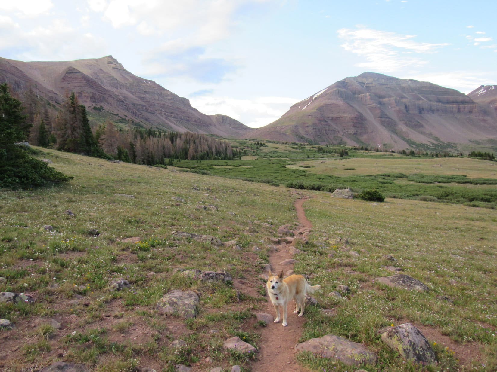
7-24-20, 6:50 AM, Henrys Fork trail No. 117, 0.5 mile S of Dollar Lake – Getting off to a reasonably early start, Henrys Fork trail No. 117 was empty as Lupe reached it.  Heading S, she could soon see Gunsight Pass, her first objective of the day, over 1.5 miles to the SE.  Although the pass was nearly 1,000 feet higher than where Loop was now, it sure didn’t look like it from here.

10 minutes after reaching the trail, Lupe came to a junction.  A sign said the path to the R went to Henrys Fork Lake.  No need to go there.  The Carolina Dog stuck with No. 117, which was already making a beeline for Gunsight Pass.  Lupe’s early start had barely beaten others to the punch.  Looking back, several groups of hikers were already hot on SPHP’s heels.

Heading for Gunsight Pass (Center). Gunsight Peak (13,263 ft.) (L)) and Dome Peak (13,103 ft.) (R). Photo looks SE.
Sign at the junction with trail No. 116 to Henrys Fork Lake.

Although she had been steadily gaining elevation nearly the whole way, as Loopster drew close to Gunsight Pass, actually getting up there was looking more difficult.  Apparently, she was still facing a rather steep rocky climb of several hundred feet.

Approaching Gunsight Pass. Hikers were already passing SPHP. Photo looks SE.

However, this proved not to be the case.  At the base of the steepest part, instead of proceeding right on up, the trail swung sharply NW along the rocky slope to the R (SW).  A steady, easy pace higher eventually brought Lupe to a second sharp corner where the trail turned SE again.  In the end, this one enormous switchback easily got the American Dingo up to a giant cairn astride Gunsight Pass.

At Gunsight Pass. Photo looks SSE.
Looking NW back into Henrys Fork Basin, where Lupe had just come from. Trail visible on the slope to the L.

From Gunsight Pass, Lupe could see Painter Basin, a vast lower region of grasslands, streams, bushes and small lakes to the SE.  In the distance, forests were visible near the ridge along the S edge of Painter Basin that culminated toward the E in Val Benchmark Peak (12,516 ft.), which looked like an easy climb if Loop had been headed that way.

Beyond the W end of the Val Benchmark Peak ridge, the Carolina Dog also had a decent view of Mount Emmons (13,440 ft.), 4th highest peak in Utah.  Even Mount Emmons appeared to be little more than a huge rounded hill, another easily climbed peak if approached from the proper direction.  The cliffy N face oriented toward Gunsight Pass, though, would clearly be another matter entirely.

Painter Basin from Gunsight Pass. Val Benchmark Peak (L). Mount Emmons (R – straight up from Lupe). Photo looks SE.

Officially, Henrys Fork trail No. 117 ended right here at Gunsight Pass, but in reality continued SE as Trail No. 68 into Painter Basin, where it would eventually link up with No. 25 going W up to Anderson Pass.  Less than a mile N of Kings Peak, Anderson Pass was the American Dingo’s next objective, but she did not take Trail No. 68 down into Painter Basin.

A steady stream of hikers also destined for Kings Peak was now coming up to Gunsight Pass from Henrys Fork trail No. 117, just like Loopster had, but none of them were proceeding down into Painter Basin, either.  Instead, everyone was veering R (S) toward a steep band of rocks along the lower E face of Dome Peak (13,103 ft.).  A relatively short, successful scramble on this route would make it possible to knock a good 2+ miles off the trek to Anderson Pass, saving an extra 600 feet of both elevation loss and gain in the process.

If everyone else could manage to get up that steep rock band, even SPHP might stand a chance, too!  Once satisfied with her inspection of Painter Basin from Gunsight Pass, Lupe joined the procession heading S along the use trail.

Trail No. 68 (visible at L) heads down into Painter Basin, but a use trail shortcut goes up the ridge seen straight ahead. Photo looks SSW.
Loop by the use trail, joining everyone else that would rather risk their necks than hike an extra couple of miles. Photo looks SSW.

Nothing to the first part of the use trail, not until it got clear over to the base of the steep, semi-cliffy, band of rock.  There, the situation suddenly became a lot more interesting.

SPHP kept a good eye on where everyone else was starting up.  It soon turned out that the use trail was somewhat braided.  Sort of a choose or make your own use trail kind of thing.  Lupe led the way higher, fully confident of her abilities to scramble up most anywhere, while SPHP tried to stick with the most popular and least exposed routes.

Following others near the start of the steep part. Photo looks SSW.
Eh, nothing to it!

A little sketchy in places, but not too bad!  Everyone was making it.  No one turned back.  Soon Lupe was through the worst of it, up on a grassy slope that wasn’t quite as steep.  The terrain got easier and easier as she began angling SW while following a series of cairns toward Dome Peak’s lower SE ridge.  As Loop got close to the ridgeline, the long, steep rocky slope of Kings Peak’s E face came into sight.

Made it! Looking NNE back down on Gunsight Pass (Center).
Following cairns toward Dome Peak’s lower SE ridge. Photo looks SW.
The E face of Kings Peak (L) comes into view. Photo looks SW.

The ridge turned out to be rounded and indistinct, but once sufficiently along it, the valley leading to Anderson Pass could be seen ahead.  This valley looked like an easy trek, but proved to be extremely rocky.  Lupe bounded along effortlessly, but crossing the pathetically simple-looking valley and getting up to Anderson Pass took SPHP 70 minutes.  As usual, others, being part mountain goat, managed it much more quickly.

Anderson Pass (L of Center) ahead! N ridge of Kings Peak (L), HP12880 (R of Center), Henrys Fork Peak (13,240 ft.) (R). Photo looks W.
Approaching Anderson Pass (R). N ridge of Kings Peak (L). Photo looks SW.

7-24-20, 10:23 AM, Anderson Pass – Getting to Anderson Pass marked the end of the preliminaries, and was an accomplishment of sorts in its own right.  From here, all that remained was the 0.75 mile scramble up the N ridge of Kings Peak (13,528 ft.).  The summit region was already in view.  South Kings Peak (13,512 ft.), Utah’s 2nd highest a mere 0.75 mile farther S along the same ridge, was in sight, too.

Loopster at Anderson Pass. Kings Peak (L) and South Kings Peak (R). Photo looks S.

Lupe enjoyed other interesting sights from Anderson Pass.  To the SW she could now see the Yellowstone Creek Basin.  The ridge leading W to Henrys Fork Peak (13,240 ft.) had an intimidating knife-edge look to it, putting a quick end to any goofy thoughts of taking that beast on.  To the NE, Dome Peak (13,103 ft.) and more distant Gilbert Peak (13,442 ft.), 3rd highest in Utah, both appeared far more feasible.

Yellowstone Creek Basin from Anderson Pass. Photo looks SW.
Gilbert Peak (Center) and Dome Peak (R). Photo looks NE.

A 15 minute breather at Anderson Pass, and that was it!  Looper started up the long rocky N ridge of Kings Peak.

Underway again. Despite appearances, the summit is way over at far R. Photo looks SE.

Talus, moderate-sized, but talus nonetheless.  SPHP is terrible on talus.  Many loose or tippy rocks.  The sure-pawed American Dingo had no problem at all.  She ended up with all kinds of time to enjoy the views while SPHP crept higher, spending it gazing this way and that.  At first, some decent use trails were present, but they soon became intermittent at best.

The W side of the ridge was scary steep, often presenting sheer cliffs.  Looper, like everyone else, stayed mostly E of the ridgeline, although at times she was right up on it.  Every now and then the top of the ridge provided short level stretches where even SPHP made rapid progress.

Right up along the cliffy W edge of the N ridge. Kings Peak (L) and South Kings Peak (R). Photo looks S.
A little E of the ridgeline in sort of a nice stair step region. Photo looks S.
At a flat spot right up on the ridgeline. South Kings Peak (R). Photo looks S.

A beautiful day in July climbing the highest peak in Utah!  The N ridge of Kings Peak had become a very busy place.  Groups of hikers streamed by.  Even a guy with a prosthetic leg passed SPHP up.  Ridiculously agile people were already on their way back down!  Lupe was kind enough not to complain about SPHP’s torpid pace.  She was getting there, bit by bit, passing one false summit after another.

Getting pretty high, but that’s still not the summit yet directly ahead.
On the only patch of snow Loop came to on the way up. Val Benchmark Peak (L) in the foreground. Albert Lake and part of larger Atwood Lake (R of Center). Photo looks SE.
A use trail reappears not too far from the top.

100 people must have beaten SPHP up the mountain.  Well, something like that.  It was a bunch!  No big deal, but by the time the true summit came into view, Lupe’s beautiful July day had come and gone, too.  Gray clouds were sweeping in out of the W.  It started to snow.

Approaching the true summit. Photo looks S.

Lupe reached the top of Kings Peak (13,528 ft.) amid a mini-blizzard of snow granules like tiny hailstones.  Hardly anyone was still at the top of the mountain, except a family of 3 who had arrived shortly before Lupe got there.  The wife and daughter were leaping into the air as husband-dad took photos.

Just a summertime squall.  The mini-blizzard soon passed off to the E.  A series of similar squalls were still on the way, but the next one wouldn’t hit for a while.  Once the family was done with their photo shoot, Looper took her turn by the summit cairn.

On Kings Peak, Utah, only Lupe’s 4th state high point. Photo looks W.
Another squall on the way. South Kings Peak (L). Photo looks SW.

The family of 3 left, but the Carolina Dog was seldom alone.  Stragglers continued to come and go, although it was clear that the big rush was now over for the day.  Lupe and SPHP remained in the summit region, hanging out while the next squall took aim at Kings Peak.

The views were grand in all directions unobscured by the snow squalls.  Not far to the N, some of the most dramatic scenes were provided by cliffs Lupe had passed by on the way up.  In the opposite direction, the ridge leading SSW to South Kings Peak (13,512 ft.) looked less daunting, although still nothing but rock the entire way.

Dome Peak (R – straight up from Lupe’s head). Gunsight Peak and Gilbert Peak (both lined up far R). Photo looks N.
Cliffs along the N ridge. Photo looks N.
Another look. HP12880 (Center) along the next ridge. Photo looks NNW.
Checking out the ridge leading to South Kings Peak (R). Photo looks SSW.

Mount Emmons (13,440 ft.) to the SE, and Tokewanna Peak (13,165 ft.) to the WNW stood out amid many other peaks of the Uinta Range.

Tokewanna Peak (R) in the distance. Photo looks W.
Mount Emmons (Center). Photo looks SE.

SPHP had hoped Lupe would get to spend an hour on Kings Peak, but 40 minutes after she arrived the next squall hit.  Thunder rumbled several times, a clear warning!  Reluctantly starting down the N ridge as it began snowing again, the tip of SPHP’s L hiking pole sizzled and buzzed when held aloft.  Somewhat concerning!  Soon snow granules were pelting Kings Peak so hard that Loop and SPHP sought partial shelter under an overhanging rock.

The American Dingo turned white.  Amazingly, even the ground way down in Painter Basin was turning white, but winter in July only lasted 10 or 15 minutes before easing up.  Lupe resumed her scenic trek down the N ridge as the squall moved E, SPHP trudging slowly and carefully along behind.  Sunshine reappeared, melting the snow almost instantly, leaving the talus slick and wet.

Heading down. Henrys Fork Peak (far L), Henrys Fork Basin (Center), Dome Peak (far R). Photo looks N.
Loopster in sunlight back at the big snowbank as the second snow squall moves away. Val Benchmark Peak (L), Mount Emmons (R). Photo looks SE.

A third squall line took aim at Kings Peak, but ended up missing to the S.  Conditions improved.  Although clouds were always around, for a while the day grew sunnier.  More hikers appeared, still on their way up the mountain.  By the time Lupe made it back to Anderson Pass, those tight new boots were beginning to bother SPHP’s paws again.

Yep.  Sadly, yesterday’s grand hopes of tackling other peaks in the region were mere delusions.  Kings Peak had been enough!

Continuing down the N ridge. Henrys Fork Peak (L). Photo looks NW.

From Anderson Pass, this time Lupe followed Trail No. 25 SE for 0.5 mile before turning NE toward Dome Peak’s SE ridge.  The trickiest part of the entire day’s scrambling was the down climb through the very steep rock band that had to be negotiated on the way back to Gunsight Pass.

Near Painter Basin (L) again. Mount Emmons (L of Center). Photo looks SSE.
Approaching Gunsight Pass again. Photo looks N.

The sun was getting low as Lupe headed down the long switchback from Gunsight Pass back into Henrys Fork Basin.  How long does it take to break in a new pair of boots anyway?  These were the worst ever, simply too tight, rubbing paws raw by the end of any long day!  SPHP hobbled along taking every step gingerly.

Seemed like a long way back.  The American Dingo was still undaunted, though!  Lupe continued roaming ahead, coming back every so often to check on Gimpy.  The evening light was awesome, the clouds moody and shifty – now pure and brilliant, now sullenly brooding.

On the way back to the tiny house.

The glorious day Lupe stood on Kings Peak (13,528 ft.), tippy top of Utah, came to an end as the Carolina Dog reached her tiny house 0.25 mile S of Dollar Lake.  A couple of campfires were blazing off to the N while the sun slid below the giant ridge W of Henrys Fork Basin.  Ahh, Utah!  How long had it been since Lupe had last spent any time here?  Years and years.  Way too long.

7-25-20, noonish –  The tiny house was all packed up.  Everything was.  Unenthusiastically, SPHP hoisted the whole heavy load, strapping it on.

Alright, sweet puppy!  This is it!  You ready?

No mountains today, SPHP?

Nope, sorry!  I’m better, but not good enough to tackle anything else.

Too bad.  Gunsight and Gilbert didn’t look that hard, and we’re already right here in perfect position!

I know it.  It’s a crying shame, but I gotta let these paws get a better rest, and we don’t have enough supplies to stay out here for days on end.  Maybe it’s not such a tragedy, though?  We need to get back pretty soon anyway to find out what the news is.  If Canada and Alaska are opening up, we’ve got lots to do to get ready.  The Most High Exalted Dingo of the Arctic Sisterhood wouldn’t want to miss out on that, would she?

No, of course not, SPHP, but do you really think it’s going to happen?  This has been such a strange year.

Good chance it won’t happen, Looper.  Maybe, though.  We’ll know soon enough.  If not, we’ve got a date with our buddy, Jobe!  In Montana!

So the adventure continues, then!

Oh, of course it does!  Wouldn’t have it any other way would we?  Onward!  Puppy, ho!

Curly tail held high, Lupe set off across the grassy plain where the tiny house had been toward the trees where she would pick up Henrys Fork trail No. 117.  Magnificent Kings Peak and the fabulous Uinta Range now receding behind her, the plucky Carolina Dog didn’t even look back.  Her second Dingo Vacation of the Year of Perfect Vision was about over; only the long road home remained.  (End, 7-26-20, 2:57 AM)

Kings Peak, Uinta Range, the Utah State High Point, 7-24-20

Links:

Next Adventure                          Prior Adventure

Kings Peak, Uinta Range, the Utah State High Point – Part 1: Henrys Fork Trailhead to Dollar Lake & Beyond!

Want more Lupe adventures?  Choose from Lupe’s Summer of 2020 Dingo Vacations to Wyoming, Utah & Montana Adventure IndexDingo Vacations Adventure Index or Master Adventure Index.  Or subscribe free to new Lupe adventures.

Kings Peak, Uinta Range, the Utah State High Point – Part 1: Henry’s Fork to Dollar Lake & Beyond! (7-23-20)

Days 12-14 of Lupe’s 2nd Summer of 2020 Dingo Vacation to Wyoming & Utah!

7-21-20, 6:10 AM, Big Sandy Opening, Wind River Range, Wyoming – The Carolina Dog was already alert, all bright-eyed and curly-tailed.  SPHP, not so much.  However, a morning stretch, turn of the key, and Lupe was on her way back down to the Lander Cutoff.  She had a blast barking at cows and gophers on the way to Pinedale, but that was the height of Dingo action for the day.

At a couple of different Pinedale parks, Loopster spent much of her time snoozing on the green grass, while SPHP caught up the trip journal.  A rest day by design, and a needed one, too.  New boots had been messing with SPHP’s paws this whole Dingo Vacation.  After Lupe’s big adventure to East Temple Peak (12,600 ft.), a couple of rest days would be more like it.

A refreshing afternoon swim in Pine Creek felt wonderful on SPHP’s sore paws.  Lupe’s paws were in better shape.  She preferred relaxing on the bank.

Loop by the great Pine Creek swimming hole she didn’t take advantage of in Pinedale. (S Taylor Avenue)

Sunset found Lupe N of town out at Willow Lake.  The big lake was pretty, but before the stars shone above, SPHP was attacked by a were-puppy and had spent the evening with a ghost.

7-22-20, 7:50 AM, 60ºF, Willow Lake – Lupe’s panting woke SPHP out of a Benadryl haze.  Another rest day, but a positioning one.  A quick stop in Pinedale, then a relaxing, scenic drive S.  SW of Green River on paved Sweetwater County Road No. 1, the Wyoming desert was so dry that even the sagebrush seemed sickly.  No cows to bark at out here, although a herd of 20 pronghorns livened things up.

SPHP had bought a small box of Junior Mints among other supplies in Green River.  A huge mistake in July.  By the time the box got opened, the whole thing was a melted chocolate fiasco.  Hah!  Far from it, in Looper’s opinion.  Licking enthusiastically for miles, she was more than willing to help clean it all up.  Traveling with the Dingo with the mintiest fresh breath in the W!  That was a new one.

At Lone Tree, SPHP turned off Hwy 414, taking a gravel road into Utah.  Signs made it easy to find the Henrys Fork picnic ground, followed by the campground and trailhead 4 miles farther.  Surprisingly few vehicles here, only around 20 including those at the campground, less than 50% of capacity.

A couple of hours got invested in an afternoon nap as light rain washed dust off the G6.  When the rain stopped, Lupe enjoyed a romp around the trailhead and a visit to the horse corrals.  The corrals were horseless, but apparently sniffed great!  A bit of blue sky appeared, raising hopes for a clear day tomorrow, but vanished as the evening wore on.  A harder rain set in, forcing a retreat to the G6.  Fried chicken for dinner, as nature turned out the lights.

7-23-20, 8:54 AM, 56ºF, Henrys Fork trailhead, Utah – A gorgeous July morning!  SPHP was about the last one ready for it.  Hikers had already set out along the Henrys Fork trail in droves.  The Carolina Dog’s late start didn’t matter.  She only had to get as far as the Dollar Lake region today, about 7 or 8 miles as best SPHP could figure it on the topo map.  The required 1,300 to 1,400 feet of elevation gain shouldn’t be bad at all over that distance.

Setting out from the Henrys Fork trailhead. Photo looks SW.

Lupe had barely left the trailhead on Henrys Fork trail No. 117 when it quickly began gaining a good 75 feet of elevation above the Henrys Fork River before leveling out up on the side of a steep slope.  The trail passed through a mostly young aspen forest, with openings that permitted fairly frequent views of the river below.  Even when the river couldn’t be seen, it could nearly always be heard.

Henrys Fork River from trail No. 117 early on. Photo looks, NE.
Among the young aspens. Photo looks SW.

20 minutes from the trailhead, Lupe got her first distant views up the valley the Henrys Fork trail was ascending.  This gentle valley was miles long, very wide, and heavily forested.  Quite a few dead trees still stood among the living.  Hemmed in on both sides by high ridges, the scene was pleasant, but free of any striking features.

For a while, the views, when present, hardly varied at all.  The only real changes were local.  The terrain flattened out, and pines increasingly dominated the forest.  Eventually, a higher, more rugged ridge with patches of snow on it could be seen ahead, still miles away.  The Henrys Fork trail now began to lose elevation, ultimately bringing Loop clear down to the Henrys Fork River at a point only a little upstream of where it flowed into a narrow gorge.

The big, but unremarkable valley ahead. Photo looks SW.
In a pine forest after the terrain leveled out. Photo looks SW.
Glimpse of the high country ahead, and the Henrys Fork River nearby. Photo looks SW.
Among the pines.
Happy Lupe by the Henrys Fork River.

SPHP expected the trail to stay close to the river for a while, but instead it again angled off to the R so far that the river could barely be heard, much less seen.  At times the trail climbed, but often the terrain was rather flat.  Looper came to quite a few minor side streams.  The first ones nearly all had small wooden bridges over them.  After a while, there were no more bridges, but since all these streams were running low and easy rock hops, it hardly mattered.

Crossing one of the numerous minor tributaries of the Henrys Fork River.

The trail went on and on.  Surprisingly, Lupe and SPHP saw no one else for miles.  The forest became much more open, full of small glades and meadows.  It wasn’t until the trail began to climb more steeply into a denser forest that hikers started appearing, both overtaking SPHP and coming down the valley.  Several groups went by on horseback.

Shortly after the terrain leveled out again, Lupe came to a major trail junction at the edge of the forest.  She had made it to Elkhorn Crossing, roughly 5 or 6 miles from the trailhead.  Noon hour.  Quite a few people and pack horses were taking a break here.  Beyond Elkhorn Crossing the valley was opening up, and a line of high peaks and ridges was in sight.

A sign said Dollar Lake and a footbridge were straight ahead.

Pack horses at Elkhorn Crossing.
Elkhorn Crossing. Photo looks SSW.
Sign at the main Elkhorn Crossing junction.

A few hundred feet beyond the Elkhorn Crossing intersection, Loopster came to a wooden bridge comprised of 3 long logs fastened together by short cross members.  A rope tied to posts at either end functioned as a hand rail.  This bridge, which crossed the Henrys Fork River, showed signs of deterioration, but was still sturdy enough to inspire confidence.

On the Elkhorn Crossing bridge over the Henrys Fork River.
An upstream view. Photo looks SW.

Once over to the E side of the river, another sign pointed Lupe S for Dollar Lake.  The trail climbed through a stretch of forest, then broke out into the open.  Henrys Fork Peak (13,240 ft.) was now in sight ahead.

After crossing the 3 log bridge, at the R (S) turn to Dollar Lake.
Henrys Fork Peak (L of Center). Photo looks S.

As Lupe continued S, the valley was widening out and becoming more beautiful all the time.  Scenic high peaks flanking both sides of the valley were bordered by dark green forests.  Most of the valley floor was out of the trees, but bright green bushes grew densely in a broad region along the unseen Henrys Fork River.  For the most part, the trail now stayed on a band of grassy terrain between the forest and shrubbery.

Mount Powell (13,159 ft.) (L) and Peak 12440 (Center). Photo looks SW.

By the time Lupe was getting close to the Dollar Lake region, the sky was clouding up.  For the first time, the Carolina Dog could see her objective, Kings Peak (13,528 ft.), the Utah state high point, on the horizon.  SPHP noted with interest that the steep ridge close to where Dollar Lake must be appeared to give relatively easy access to Gunsight Peak (13,263 ft.).

Gunsight Peak (L – straight up from Lupe’s tail) and Kings Peak (R). Photo looks SSE.
Gunsight Peak (Center). Photo looks SSE with help from the telephoto lens.

Henrys Fork trail No. 117 continued just about due S.  Dollar Lake was only 2 miles from Elkhorn Crossing, so it couldn’t be much farther.  The sky kept changing, but so far the American Dingo was lucky.  No rain yet!

The beautiful Henrys Fork basin. Henrys Fork Peak (L). Mount Powell (far R). Photo looks SW.
Approaching the Dollar Lake area. HP 12089 (Center), Gunsight Pass (R). Dollar Lake is hidden in the forest beyond Lupe. Photo looks SSE.
Crossing a tributary of Henrys Fork River. HP12089 (L), Dome Peak (13,103 ft.) (Center), Kings Peak (R). Photo looks S.

No signs for Dollar Lake, but Lupe found it E of the trail 200 yards into the forest.  Lots of nice campsites, only some of which were taken, were scattered among the trees not too far from the lake.  However, SPHP wanted to go a bit farther to get closer to Gunsight Pass.  Maybe Loop could camp where she would have a view of Kings Peak?

At Dollar Lake. HP12089 (R). Photo looks SE.
Dollar Lake. Photo looks NE.

Continuing S about 0.25 mile from Dollar Lake, Lupe climbed up onto a wide grassy bench.  Coming here had been a terrific decision!  Looper had a sweeping view of the S end of Henrys Fork basin, and all the peaks bordering it.  Kings Peak was in sight, too, as well as a small tarn nearby featuring an unusual rock island shaped like a platform.

By 2:45 PM, SPHP had Lupe’s tiny house set up.  Over by the ridges W of the valley, the weather was looking dark and threatening.  After the long march from the Henrys Fork trailhead, it seemed like a good time for a late lunch and a nap.  Loopster was in complete agreement.

The tiny house, set up 0.25 mile S of Dollar Lake. Peak 12440 beyond it. Photo looks W.
Ready for a mid-afternoon snooze.

7-23-20, 6:36 PM, Henrys Fork basin, 0.25 mile S of Dollar Lake – The nice long nap had done some good.  Rain and dark clouds were gone.  Lupe emerged from her tiny house to sunny skies.  Slanty evening sunlight heightened contrasts, highlighting the beauties of Henrys Fork basin.

The lucky American Dingo had this fabulous evening free to roam to her heart’s content!  First she went down to the half dried-up tarn with the rock platform island, for a closer look at it and Kings Peak (13,538 ft.), sandwiched between and slightly behind Dome Peak (13,103 ft.) and Henrys Fork Peak (13,240 ft.).

Sniffing near HP12089 (Center). Photo looks SE.
By “Platform Pond”. Dome Peak (L). Kings Peak (beyond the platform island). Photo looks S.
Kings Peak (L) and Henrys Fork Peak (R). Photo looks S.

From “Platform Pond”, Looper ventured far enough W to see the trail she would take to Gunsight Pass tomorrow.  Here she enjoyed a fabulous view of the SW portions of Henrys Fork basin.  Loop then wandered N until part of Dollar Lake could be seen in the forest below the slope she’d come up earlier this afternoon.

Henrys Fork basin. Henrys Fork Peak (far L). Cliff Point (13,064 ft.) (L). Photo looks SW.
Kings Peak (Center), Dome Peak (L), and Henrys Fork Peak (R). Photo looks S.
Dollar Lake (L). Photo looks NNE.

Lupe returned to the tiny house, but didn’t go inside.  Such a gorgeous evening!  Loop was going to stay out until the sun disappeared behind the ridge W of Henrys Fork basin.

Such a terrific evening! The Uinta Range is incredible! Kings Peak (L), Henrys Fork Peak (R of Center), and Cliff Point (R). Photo looks SSW.
Home, sweet home for tonight! Dome Peak (L), Kings Peak (L of Center), Henrys Fork Peak (R) and Cliff Point (far R). Photo looks SSW.
HP12089 (L), Gunsight Pass (Center), Dome Peak (R) and Kings Peak (far R). Photo looks SSE.

Still plenty of daylight!  There had been a line of rocks creating a bridge out to the platform island at Platform Pond.  Maybe Lupe ought to go back and visit the island?

Dome Peak (Center) beyond Platform Pond. Kings Peak (R). Photo looks S.
On “Platform Island”. HP 12089 beyond. Photo looks SE.
Platform Pond. Photo looks NE.

Rested up from a long afternoon nap, and awed by the splendor of the Uinta Range – a dangerous combination!

As Lupe spent the evening happily roaming this exquisite corner of Henrys Fork basin, a promised land bathed in the glorious light of the fast sinking sun, SPHP’s troublesome boots and resulting sore paws of only a couple of days ago were long forgotten.  A bad case of mountain madness set in.

Growing increasingly optimistic and enthusiastic by the moment, SPHP’s fevered noggin envisioned the American Dingo trotting not only to the top of Kings Peak (13,538 ft.) tomorrow, but also up all these other grand and glorious mostly 13,000+ foot peaks in the next couple of days.  Why, obviously, all these enormous ridges leading to one stunning peak after another would be nothing but a stroll in the park!

High on Utah, how many of these happy thoughts reflected reality, and to what extent they were mere delusional Dingo mountain dreams, only tomorrow would tell.

Kings Peak (L) from Henrys Fork basin, Uinta Range, Utah 7-23-20

Links:

Next Adventure                         Prior Adventure

Kings Peak, Uinta Range, the Utah State High Point – Part 2: To Gunsight Pass & the Summit! (7-24-20)

Want more Lupe adventures?  Choose from Lupe’s Summer of 2020 Dingo Vacations to Wyoming, Utah & Montana Adventure IndexDingo Vacations Adventure Index or Master Adventure Index.  Or subscribe free to new Lupe adventures.

Book Review: The Klondike Cafe – A Bud Shumway Mystery #11 by Chinle Miller

6-30-20 –  Hey, Loopster, come here!  Get a load of this!

What is it, SPHP?

Now that we’re temporarily back from your first Summer of 2020 Dingo Vacation, I’m checking on some of the cool comments that came in for you on T(M)TAOL while we were gone.  You’re never going to believe this one!

Really?  Don’t keep me in suspenders, SPHP!  What does it say?

Suspense, not suspenders, Loop.  Anyway, here goes:

“I hope you don’t mind that I dedicated my book to you, Lupe. If you contact me, I’ll send you a free copy. Even though I’ve been in Tombstone, your adventures helped inspire it, as well as you being who you are.”

A book dedicated to me!  Mind?  Why would I mind?  That’s a great honor, isn’t it?  Who wrote that comment?

A great honor?  You better believe it is, Loop!  Not every day that someone dedicates a book to you.  In fact, until now, not any day was.  Considering that most people never ever write a book in the first place, and then that the author doesn’t even know you except through T(M)TAOL, this is like getting struck by lightning!

Actually, this is a lot better than getting struck by lightning, SPHP!

Well, of course.  I didn’t mean it literally, just that this is an extraordinarily rare event.

So, you still haven’t told me who wrote that comment.  And what’s the book called?

The comment is from Chinle, Chinle Miller.

Oh, Chinle!  I like Chinle.  Chinle has written quite a few nice comments on T(M)TAOL.  You never told me she was an author, though.

There’s a reason for that.  I didn’t know it, either, until now.  Chinle must really like you, too, Looper.  One of your biggest fans!  Dedicating a book she spent who knows how long writing to you is absolute proof, as if any was needed.  Why, Chinle must have been planning this for ages!

Lupe beamed from big soft Dingo ear to big soft Dingo ear.

OK!  So back to the name of this book, SPHP.  What’s it called?  What’s it about?  Can you send for my free copy right now?

Sure, we’ll send Chinle a reply.  I don’t know what the book is called, but there’s a link that Chinle sent along with the comment.  Let’s check it out.

The link went to an Amazon page.

Hey, hey!  Here it is, Loop!  Wow, totally legit!  The Klondike Cafe (Bud Shumway Mystery Series Book 11) by Chinle Miller.  Rated 4.7 out of  5.0 stars on Amazon!  That’s mighty good.  People must really like it!

The Klondike Cafe?  Must be about Canada!  We’ve been to the Klondike Highway and the Klondike River, right?  Don’t remember ever being at the cafe, though.  What else does it say, SPHP?

The cafe might be fictional, Loop.  Not sure.  The Klondike Cafe is a novel.  There’s a synopsis.  Listen to this:

“When a Mountie shows up in Sheriff Bud Shumway’s Utah office and accuses him of aiding and abetting a possible murderer in Canada’s Yukon Territory, Bud is mystified, especially since he doesn’t even know the guy. And when he receives a gold-mining claim transferred to his name and a cryptic message telling him to come to the Klondike Cafe, Bud is soon on his way, even though he has no idea where the cafe is or why his help is needed.

Join Bud on the adventure of a lifetime, as he discovers the beauty and sometimes deadly lure of the North Country, the land once charted on maps as the “Great Northern Mystery.”

A murder mystery!  I didn’t expect that, SPHP, but I was right about Canada, wasn’t I?  The sheriff goes to the Yukon to solve the case, and get rich mining gold!  Sounds like The Klondike Cafe must have a lot more of a plot than our adventures do.  We’re always like, “Here’s a cool mountain, let’s see if we can get to the top?”  Usually different mountains, but sort of the same thing every time.  No one gets killed on our adventures.

No, they don’t.  Planning on keeping it that way, too!  If people want more drama than we provide, they’d be better off reading The Klondike Cafe.  Anyway, there’s more here, another link.  Apparently to a bio about Chinle.

So, read it to me!

Intend to, Looper:

About Chinle Miller

Chinle Miller wanders the outback of Colorado and Utah, eyeing civilization from a safe distance.  She’s accompanied by her dogs and occasional ravens.

She has a B.A. in Anthropology and an M.A. in Linguistics and an A.S. in Geology.

Short and sweet, but does sort of explain why Chinle likes you, Loop.  She has dogs, and enjoys spending time with them out in remote places, just like you and me.  In fact, sounds like she’s more of a real nomad than we are.  Most of the time, we’re at home.  Civilization does have its perks!

Oh, and she’s a geologist, too, SPHP.  Which means she must like rocks.  Mountains have a lot of rocks, so maybe she likes that I climb mountains?  She might not be such a complete nomad like you’re saying, though.  Most nomads don’t spend that much time in school.  An M.A. in Linguistics!  Wonder if Chinle and her dogs talk like we do?

Of course, they do.  I’m sure of it!  Here, let’s send Chinle a response right now.  Thank her for the grand honor she’s bestowed upon you, and get that free copy of The Klondike Cafe on the way.

Chinle responded the very next day.  It was going to take a little while, but she would get The Klondike Cafe sent to Lupe as soon as she could, personally autographed, no less!  Amazingly, it got even better than that, as Chinle went on to say “Thanks, but you’re the real star, Lupe, and beautiful to boot!  But I think you’ll like Lindie, the dingo in the book, as she’s based on you, though I make her look a little more coyote like.”

A murder mystery in the Yukon with a Dingo named Lindie playing a role!  Lupe and SPHP were both excited.  The Klondike Cafe was really something to look forward to!

July.  Adventure season!  The Klondike Cafe arrived while Lupe was out climbing mountains in Wyoming and Utah during her second Summer of 2020 Dingo Vacation.  There it was, though, brand spanking new when she returned home on July 26th.

200 pages long, quick-paced, and mostly light-hearted (despite being a murder mystery!)  And, oh boy, was The Klondike Cafe ever good!  As the synopsis and title of the series indicated, Sheriff Bud Shumway is the star.  Early on he is astonished to find himself inexplicably entangled in a murder he doesn’t know anything about, yet suspected by the Canadian Mounties of somehow having a hand in it.

Sheriff Shumway is soon reluctantly leaving his semi-capable deputy, Howie, in charge of things back in his hometown of Green River, Utah, and is on his way to the far north to figure out not only who done it, but exactly what, how, and why they’d done it.  Bud’s very capable wife, Wilma Jean, a pilot and business owner, is also left behind trying to stay in touch with her husband while taking care of the watermelon farm they own, plus their two dogs Hoppie and Pierre.

Realizing this trip will be a rare chance for adventure in places he’s only dreamed of before regardless of how the murder mystery he’s wrapped up in turns out, Bud brings along his harmonica, which he is learning to play, and a camera to take photos of the Northern Lights.

In addition to all the fixes Bud finds himself in as the plot unfolds, The Klondike Cafe is sprinkled not only with brief geology lessons, but bits of information on Canadian First Nations, too.  Everywhere he goes, Sheriff Shumway meets an interesting cast of characters all with problems, likes and dislikes, motivations, and dreams of their own.  Meanwhile, Chinle is busy slipping in snippets of her sneaky sense of humor, as well.  “Palatial Estates Trailer Park”!  SPHP had to laugh, yet you just know such a contradiction in terms might actually exist.

Bud makes it to Skagway, Alaska, a major cruise ship port and start of the White Pass Railroad that goes through Fraser up to Carcross in the Yukon, passing Lindeman and Bennett Lakes along the way.  The action takes him to Whitehorse, capitol city of the Yukon, where paddle wheel steamships once provided transportation and brought in supplies in the days before roads; Dawson City, heart of the Klondike Gold Rush, with its free ferry across the Yukon River to the Top of the World Highway; and up the Dempster Highway to the spectacular trail to Grizzly Lake in Tombstone Territorial Park.

Since Lupe and SPHP have been to so many of the incredible places Bud visits in The Klondike Cafe, that really helped to make it all come alive.  Despite Chinle’s considerable descriptive powers, readers who’ve never been to these parts of Canada or Alaska might have a harder time fully appreciating the amazing wilderness stage upon which Sheriff Shumway’s sleuthing plays out.

For Lupe, The Klondike Cafe was more than just an exciting tale of Bud’s adventures and travails while trying to solve the mystery at paw, it was a constant reminder of all the great adventures she’d been on with SPHP in the same areas Bud was getting to know.

Taiya Inlet and Skagway (L) as seen on the way up AB Mountain to join the Arctic Sisterhood, Alaska 8-7-17
Cruise ship in Skagway, Alaska 8-7-17
White Pass & Yukon Route train in Skagway, Alaska 8-7-17
The Most High Exalted Dingo of the Arctic Sisterhood at the Arctic Brotherhood hall in Skagway, Alaska 8-8-17
Exploring past the end of the International Falls trail, which crosses the US/Canada border between Skagway & Carcross, 8-8-17
On Fraser Peak, British Columbia near the US/Canada border, 8-9-17
In Carcross, Yukon Territory, 8-6-17
Carcross and Bennett Lake as seen on the way up Nares Mountain, Yukon Territory, 9-10-18
In Whitehorse, by the S.S. Klondike, which used to ply the upper Yukon River between Whitehorse and Dawson City, Yukon Territory 8-10-17
On Grey Mountain (Canyon Mountain) near Whitehorse, Yukon Territory, 9-9-18
Dawson City and the Yukon River from Midnight Dome, Yukon Territory 8-23-18
Lupe reaches Tombstone Territorial Park near kilometer 50 of the Dempster Highway, Yukon Territory 9-3-17
Approaching Grizzly LakeMount Monolith (R).  Tombstone Territorial Park, Yukon Territory, 9-6-17
At the Dawson City General Store, Yukon Territory 9-3-17
The free ferry across the Yukon River in Dawson City, Yukon Territory 9-3-17
Top of the World Highway from Swede Dome, Yukon Territory 8-24-18

“They all walked inside and on to better things.”  So that’s it, Looper.  The end.  Wha’dya think?

The Klondike Cafe was a great story, SPHP!  You ought to learn to write like that.  One bad thing about it, though!

Really?  I thought it was terrific!  What didn’t you like?

Makes me wish we were up in the Yukon having more adventures of our own right this very minute!

Yeah, me too!  Sort of a fabulous trip down memory lane for us, wasn’t it?  Got any favorite parts?

Oh, I liked Sheriff Shumway’s adventures and harmonica playing, but I loved Lindie best of all.  So courageous!  She not only helped Bud find the Klondike Cafe, she even helped solve the murder mystery, too, you know!  Good press for all of us American Dingoes!  For some strange reason, Carolina Dogs don’t get much of that.

So you loved Lindie best of all, Lupe?  Well, knock me over with a feather.  Who’da thunk it?  Guess we’ve got partners now in Lindie and Sheriff Bud Shumway helping to spread the word on Carolina Dogs and their love of adventure!

Thank you, Chinle!

We’ll always treasure The Klondike Cafe!   –  Lupe & SPHP

North Klondike River in Tombstone Territorial Park, Yukon Territory 9-4-17
Dingo endorsed!

Links:

The Klondike Cafe on Amazon

In addition to the Bud Shumway Mystery Series, Chinle is the author of Desert Rats: Adventures in the American Outback, Uranium Daughter, The Impossibility of Loneliness, In Mesozoic Lands: The Mesozoic Geology of Arches and Canyonlands National Parks, plus several U.S. National Park guides.

Chinle Miller on Amazon

Want more Lupe adventures?  Choose from Lupe’s Dingo Tales IndexBlack Hills of South Dakota & Wyoming Expeditions Index, or Dingo Vacations Adventure Index.  Or subscribe free to new Lupe adventures.