
SPHP wasn’t very well organized. It took longer than it should have to get going. Finally, at noon, Lupe and SPHP were on their way in the G6.
Lupe was already expecting great things! She was riding up high on a small mountain of gear, blankets and pillows, as if she was starting off on one of her Dingo Vacations. That wasn’t what was happening, but this was going to be a special overnight outing. Lupe was going to get to do two Black Hills, SD Expeditions in a row!
Lupe’s peakbagging goals were all clustered in the SW Black Hills, not too far from the Wyoming border. First up was an easy one, Surveyor’s Hill (5,640 ft.). SPHP parked the G6 at a curve in USFS Road No. 668 down in Hay Draw (1:48 PM, 58°F). All Lupe had to do to get up to Surveyor’s Hill was follow a side valley NW for 0.375 mile. Surveyor’s Hill was a minor hill sitting up on a larger ridge that lost elevation as it went SW.
Lupe started off doing just fine, following an animal trail at the bottom of the side valley. However, when SPHP left the animal trail to start gaining elevation faster on the NE side of the valley, Lupe hesitated. She remembered all the cactus around on her recent trip to the Wildcat Hills of Nebraska with mountaineer Jobe Wymore. There had also been cactus around on her last couple of Black Hills, SD Expeditions, too.
Lupe didn’t want to leave the safety of the animal trail. Even though SPHP didn’t see any cactus, it took some persuading to convince Lupe to keep going. Lupe repeatedly sat down and lagged behind. She only came when SPHP got too far away, or stopped to sit down and “check the maps”. A few times, SPHP had to carry her.
Fortunately, it wasn’t far to Surveyor’s Hill, and there really didn’t seem to be any cactus around. Lupe gradually regained her confidence. Once she was up on the ridge at the base of Surveyor’s Hill, she started feeling secure enough to lead SPHP the rest of the way up.

For such a small hill, the scenic rewards when Lupe reached the top were very nice. The forest on Surveyor’s Hill completely burned away in the Jasper Fire in August, 2000. As a result, Surveyor’s Hill has a commanding 360° view. Some of the best views were off to the SW.


Lupe liked it up on Surveyor’s Hill. She really didn’t want to follow SPHP down the S slope when it was time to go. She still suspected she was being lured back down into dangerous cactus country. SPHP went a long way down before Lupe finally decided she didn’t want to risk being left behind.

On the short trek back to the G6, Lupe’s confidence continued to build. Instead of encountering cactus, she saw a squirrel! All the painful thoughts of cactus disappeared, wiped out in an instant by the exciting squirrel. With the squirrel’s help, by 2:34 PM (58°F) Lupe was back at the G6, and on her way to Red Butte (5,500 ft.).
SPHP parked the G6 again down in Gillette Canyon, at the junction of USFS Roads No. 281 & No. 281.1V. Red Butte was only a little over 0.5 mile WNW as the crow flies. On the first part of the journey, Lupe and SPHP followed No. 281.1V. Red Butte was soon in sight across a big field.

Lupe and SPHP stayed on No. 281.1V as it crossed a big field heading for Red Butte. When the road reached the trees, it started gaining elevation. Lupe and SPHP stayed on the road only until it started curving NE, then Lupe left it climbing NW directly up the forested ridge.
Once again, Lupe was reluctant to follow SPHP off the road. Her fear of cactus returned. Again and again, she stopped and watched while SPHP plodded away. When SPHP got too far ahead, she waited for SPHP to stop and look back at her. Then she ran to catch up. In this manner, Lupe and SPHP progressed steadily, though more slowly than normal.
When Lupe reached the top of the ridgeline, she turned WSW following the ridge toward the summit of Red Butte. SPHP still saw no cactus around. Lupe’s confidence grew.
The steepest part of the climb came at the end. The summit of Red Butte was up on top of a hill thickly covered with 3 foot high bushes. Lupe liked the bushes, and the many pathways between them. She forgot all about cactus, sniffing her way through the bush maze. For SPHP, the bushes were more of a pain to navigate, but soon both Lupe and SPHP stood on the summit of Red Butte.


The true summit of Red Butte was near the ENE end of the short summit ridge close to where Lupe initially reached the top. However, there was another high point off to the WSW. After visiting the true summit, Lupe and SPHP headed over to this second high point to take a look at things from there. On the way, SPHP suddenly spied a large patch of cactus ahead.
Right away, SPHP stopped Lupe and put her leash on. Lupe had been so engrossed with exploring the maze of bushes, she didn’t yet realize there was any cactus around. To make certain Lupe didn’t have a bad experience, SPHP carried her over the cactus patch to reach the second high point.

With cactus around, Lupe and SPHP didn’t stay long on the WSW high point. It was quite close to the true summit, so the views weren’t much different anyway. SPHP carried Lupe back over the cactus patch to the true summit again. A break between the trees provided a look at nearby Yellow Butte (5,460 ft.), where Lupe would be headed next.

Lupe and SPHP left Red Butte heading back down the way Lupe had originally come up. Lupe followed the ridgeline NE back to USFS Road No. 281.1V. Lupe came to no more cactus, and although SPHP kept a careful lookout, SPHP saw no more cactus the rest of the day.

When Lupe reached USFS Road No. 281.1V again, she followed it N for about 0.33 mile. She then came to an intersection where she turned W. She soon passed by No. 281.1A coming up Hop Draw. From this point, No. 281.2Y led Lupe W the rest of the way to Yellow Butte. In this manner, Lupe effectively went around the E end of Hop Draw coming from Red Butte.
Although Yellow Butte is a little lower than either Surveyor’s Hill or Red Butte, it is a much craggier, and therefore more interesting peak. In fact, SPHP wasn’t at all certain that Lupe would find a way up to the summit. As Lupe approached Yellow Butte, there appeared to be a reasonably safe way up near the S end of the E face, but SPHP didn’t really like the looks of it all that much.

Instead of heading toward the big cracks in the rocks toward the S end of the E face, Lupe and SPHP went to check out the N end first. The N end of the E face wasn’t encouraging at all.
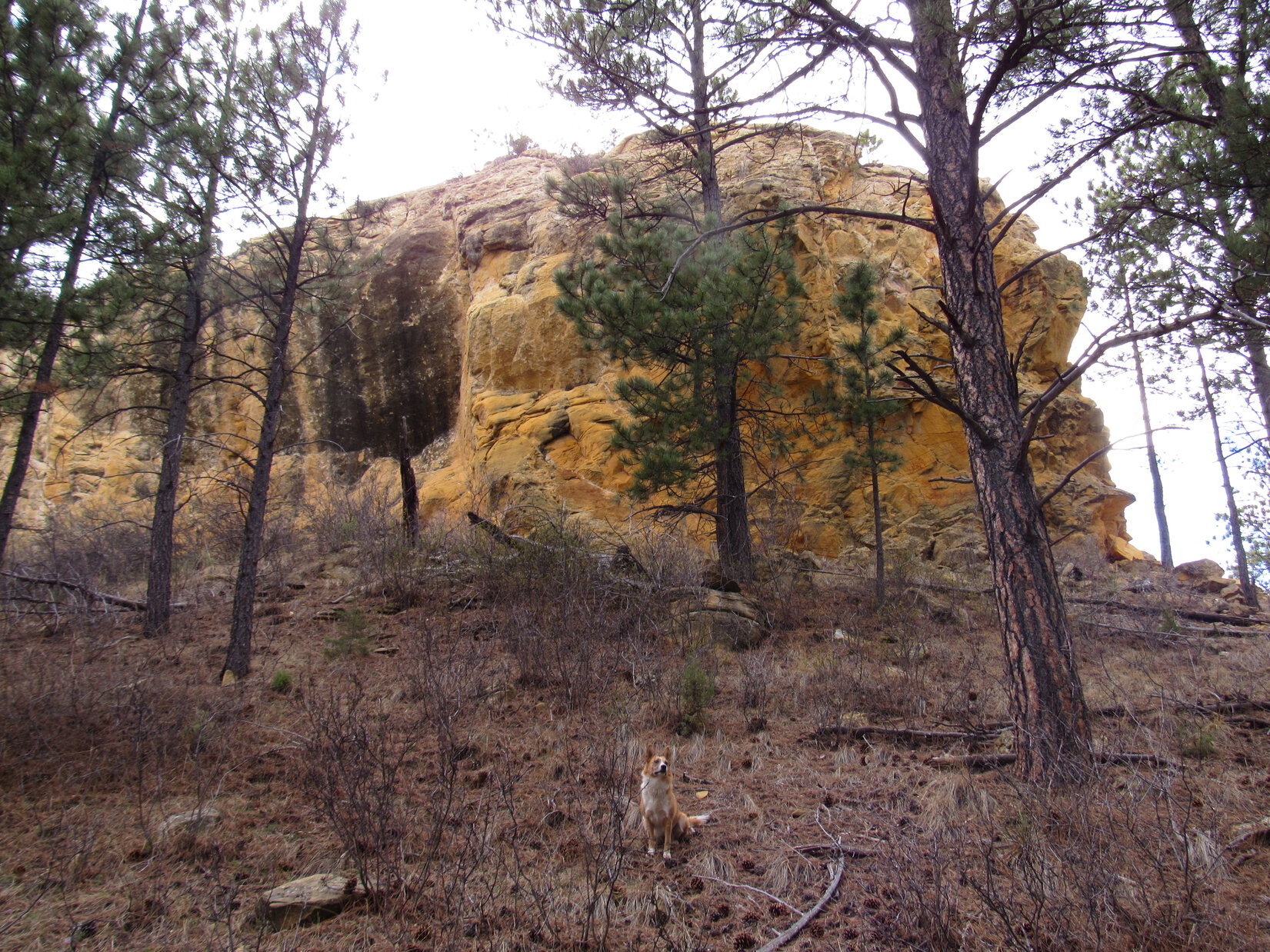
Yellow Butte was certainly well named! The entire mountaintop appeared to consist of a massive very yellow rock outcropping with near vertical, and in some places overhanging, walls. The narrow N end of the mountain featured beautiful yellow, overhanging cliffs.

The northern portion of the W face of Yellow Butte was a towering, vertical yellow rock wall.

It was starting to look like Lupe and SPHP might have no choice. The large steep cracks in the rocks on the E face might be the only possible way up. However, as Lupe drew near the S end of the W face, suddenly there was a break in the sheer cliff wall. A ramp of relatively easy terrain led all the way up to the top of the massive rock formation.
Surprisingly, the first rocks Lupe encountered on top were not yellow at all. The true summit, which is closer to the S end of the mountain, consisted of a very different, but interesting gray-pink rock full of holes, lines and pockets.


After visiting the summit, Lupe went to explore the flat top of the yellow rocks toward the N end of the mountain. Exposed rock covered most of a fairly large area, but scattered trees and bushes grew here and there, too. Cliffs were to the W, N and E.

Yellow Butte was quite an interesting place. SPHP was glad Lupe had found an easy way up. Before departing, Lupe briefly returned to the summit one more time. Then she headed back down the relatively easy ramp near the S end of the W face.


Lupe returned to USFS Road No. 281.2Y. She followed it E to No. 281.1V again, which she stayed on all the rest of the way back to the G6 (5:49 PM, 55°F).
SPHP’s original plan had been for Lupe to head on over to Wildcat Peak (5,500 ft.) next, but the very late start earlier in the day meant it was already too late now for that adventure. Lupe would get a chance to climb Wildcat Peak tomorrow. In the meantime, Lupe had another fun alternative close to Wildcat Peak. She could go to the Elk Benchmark (5,669 ft.).
Lupe had been to the Elk Benchmark once before, a little over a year ago on Black Hills SD Expedition No. 125. Both Lupe and SPHP had a great time there then. The Elk Benchmark is located at the NW corner of Elk Mountain, a high ridge on the border with Wyoming. The ridge runs N/S for several miles. The S end of the ridge is heavily forested, but years ago a forest fire burned virtually all the trees off the N end.
USFS Road No. 118 passes very close to the true summit at Elk Benchmark on its way to the Elk Mountain Lookout Tower (5,662 ft.), so it’s possible to drive almost right to it. However, a year ago Lupe and SPHP had found it much more fun to travel the broad treeless portion of the ridge on paw and foot. Lupe enjoyed chasing the numerous rabbits, and SPHP loved the big sweeping views.
Since USFS Road No. 118 traverses the entire length of Elk Mountain, Lupe and SPHP could stay out long after dark without worrying about getting lost. Repeating Lupe’s prior journey to the Elk Benchmark would be a perfect way to end the day! So when Lupe reached the G6 again after her visit to Red and Yellow Buttes, it was time to press on to Elk Mountain.
By 6:30 PM (54°F), SPHP was parking the G6 at the junction of USFS Roads No. 118 and No. 118.1C. This junction was up on top of the Elk Mountain ridge at the S end of the burned area. Elk Benchmark was still at least 2 miles N. Before heading N, Lupe and SPHP made a short trek over to the E side of the ridge for a look at Wildcat Peak to the S.

After a good look at Wildcat Peak, Lupe and SPHP went back to No. 118 to start following it N. Lupe quickly rediscovered the existence of rabbits up on Elk Mountain. The enthusiastic Carolina Dog bounded away. She was off and running! Fortunately, there didn’t seem to be any cactus to worry about. Even though the rabbits had all the advantages on their home ground, Lupe had an exhilarating time sniffing excitedly for them and giving chase.
Meanwhile, SPHP was enjoying the tremendous views. To the W, a broad swath of eastern Wyoming could be seen. To the E, the southern Black Hills of South Dakota. Far away, almost indiscernibly faintly on the SSW horizon, SPHP could even see Laramie Peak (10,272 ft.).


Lupe and SPHP barely made it to the Elk Benchmark summit before sunset. The world was all aglow with a soft yellow-orange light. Off to the SE, the Elk Mountain Lookout Tower stood on another high point almost as high as where Lupe was.


Lupe and SPHP took a break at the Elk Benchmark while the sun sank below the horizon. On Lupe’s trip here more than a year earlier on 4-4-15, Lupe and SPHP had gone on to see the Elk Mountain Lookout Tower, and another nearby high point featuring the Most Colorful Rock. This time, it would have gotten dark before Lupe could get over there, so there wasn’t any point in going.
Lupe and SPHP just relaxed enjoying the glorious view until the light started fading from the clouds.

Lupe and SPHP didn’t start back toward the G6 until 10 or 15 minutes after the sun disappeared. Then Lupe led the way, resuming her futile, but enormously entertaining rabbit hunts. Darkness grew in the E. The orange glow in the W faded. Gradually it became harder and harder for SPHP to see the happily roaming Carolina Dog. She became a phantom of the night, disappearing and reappearing at will.
A huge, white moon obliterated most stars and cast ghostly shadows. Tomorrow the moon would be full. The long trek back was marvelous. At 9:08 PM, it was over. Lupe and SPHP were back at the G6, but to Lupe’s delight, she wasn’t going home. Together, Lupe and SPHP would spend this night on Elk Mountain! Links:
Next Black Hills Expedition Prior Black Hills Expedition
Want more Lupe adventures? Choose from Lupe’s Black Hills Expeditions Adventure Index, Dingo Vacations Index, or Master Adventure Index. Or subscribe free to new Lupe adventures.